Deltas: The Mouths of Rivers
Sooner or later, all rivers end as they flow into a lake or an ocean, mix with the surrounding water, and—no longer able to travel downslope—gradually lose their forward momentum. The largest rivers, such as the Amazon and the Mississippi, can maintain some current many kilometers out to sea. Where smaller rivers enter a turbulent, wave-swept sea, the current disappears almost immediately beyond the river’s mouth.
Delta Sedimentation
As its current gradually dies out, a river progressively loses its power to transport sediments. The coarsest material, typically sand, is dropped first, right at the mouths of most rivers. Finer sands are dropped farther out, followed by silt and, still farther out, by clay. As the floor of the lake or ocean slopes to deeper water away from the shore, the deposited materials build up a large, flat-topped deposit called a delta. (We owe the name delta to the Greek historian Herodotus, who traveled through Egypt about 450 b.c. The roughly triangular shape of the sediment deposit at the mouth of the Nile prompted him to name it after the Greek letter Δ, delta.)
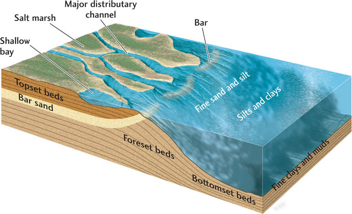
As a river approaches its delta, where its slope is almost level with the ocean surface, it reverses its upstream-branching drainage pattern. Instead of collecting more water from tributaries, it discharges water into distributaries: smaller streams that receive water and sediments from the main channel, branch off downstream, and thus distribute the water and sediment into many channels. Materials deposited on top of the delta, typically sand, make up horizontal topset beds. Downstream, on the outer front of the delta, fine-grained sand and silt are deposited to form gently inclined foreset beds, which resemble large-scale cross-beds. Spread out on the seafloor seaward of the foreset beds are thin, horizontal bottomset beds of mud, which are eventually buried as the delta continues to grow. Figure 18.18 shows how these structures form in a typical large marine delta.
The Growth of Deltas
As a delta builds outward into the ocean, the mouth of its river advances seaward, leaving new land in its wake. Much of this land is a delta plain just a few meters above sea level. At the seaward edge of the plain, broad depressions between distributary channels lie below sea level and form shallow bays that fill with fine-grained sediments. With time, they fill further and ultimately become salt marshes (see Figure 18.18).
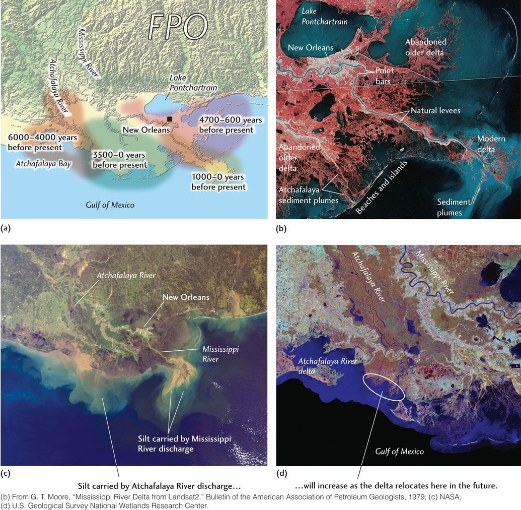
As a delta grows, the river flow shifts from some distributaries to others that provide shorter routes to the sea. As a result of such shifts, the delta may grow in one direction for some hundreds or thousands of years, then the main stream may break out into a new distributary, sending sediments into the ocean in another direction. In this way, a major river may form a large delta thousands of square kilometers in area. The delta of the Mississippi has been growing for millions of years. About 150 million years ago, it started out around what is now the junction of the Ohio and the Mississippi rivers, at the southern tip of Illinois. It has advanced about 1600 km since then, creating almost the entire states of Louisiana and Mississippi as well as major parts of adjacent states. Figure 18.19 shows the growth of the Mississippi delta over the past 6000 years, as well as the direction its growth is likely to take in the future.
514
515
Deltas grow by the addition of sediment, and they sink as the sediment becomes compacted and Earth’s crust subsides under the weight of the sediment load. Venice, built on part of the Po River delta in northern Italy, has been sinking steadily for many years. Both crustal subsidence and depression of the ground attributable to the pumping of water from aquifers beneath the city are responsible for its sinking.
Human Effects on Deltas
The extensive wetlands found in delta plains are valuable natural resources because, like all wetlands, they store floodwaters and provide habitat for many diverse species of plants and animals, as noted in Chapter 17. The wetlands of the Mississippi River delta, like delta wetlands in many other areas, have suffered a two-pronged attack. First, the extensive flood-control dams built on the river since the 1930s have decreased the volume of sediment brought to the delta, thereby reducing the sediment supply to the wetlands. Second, massive artificial levees have prevented the small but frequent floods that nourish the delta wetlands with sediments. At New Orleans, the Mississippi River floodplain has sunk below the level of the river, making future catastrophic flooding more likely.
The Effects of Ocean Currents, Tides, and Plate Tectonic Processes
Strong waves, ocean currents, and tides affect the growth and shape of marine deltas. Waves and ocean currents may move sediment along the shore almost as rapidly as it is dropped there by a river. The delta front then becomes a long beach with only a slight seaward bulge at the river mouth. Where tidal currents move in and out, they redistribute delta sediments into elongate bars parallel to the direction of the current, which in most places is at approximately right angles to the shore (see Figure 18.19b).
In some places, waves and tides are strong enough to prevent a delta from forming. Instead, the sediments a river transports to the ocean are dispersed along the shoreline as beaches and bars and transported into deeper waters offshore. The east coast of North America lacks deltas for this reason. The Mississippi has been able to build its delta because neither waves nor tides are very strong in the Gulf of Mexico.
Plate tectonic processes also exert some control over where deltas form because delta formation has two other preconditions: uplift in the drainage basin, which provides abundant sediments, and crustal subsidence in the delta region to accommodate the great weight and volume of those sediments. Two of the world’s large deltas—those of the Mississippi and the Rhône (in France)—derive their sediments primarily from distant mountain ranges: the Rockies for the Mississippi and the Alps for the Rhône. Both are in the same type of plate tectonic setting: a passive margin originally formed by continental rifting. The active continent-continent convergence that is elevating the Himalaya has also formed the great deltas of the Indus and Ganges rivers.
Few large deltas are associated with active subduction zones. The reason may be that it is unusual for a large river (such as the Columbia River of the Pacific Northwest) to carry abundant sediment through a volcanic mountain belt (such as the Cascade Range) to the sea. Furthermore, these rapidly uplifting areas are too unstable for large deltas to develop. Oceanic island arcs are too small in land area to provide much siliciclastic sediment to their streams.