The Desert Environment
Of all Earth’s environments, the desert is where wind is best able to do its work of erosion, transportation, and deposition. The deserts of the world are among the most hostile environments for humans. Yet many of us are fascinated by these hot, dry, apparently lifeless zones, full of bare rocks and sand dunes. The dry climate of deserts creates harsh yet fragile conditions, where human impacts last for decades.
All told, arid regions amount to one-fifth of Earth’s land area, about 27.5 million square kilometers. Semiarid plains account for an additional one-seventh. Given the reasons for the existence of large areas of desert in the modern world—the effects of Earth’s wind belts on climates, mountain building, and continental drift—we can be confident that, according to the principle of uniformitarianism, extensive deserts have existed throughout geologic time. Conversely, today’s deserts may have been wet regions in the past, but may have dried out as a result of long-term climate change.
Where Deserts Are Found
The locations of the world’s great deserts are determined by rainfall, which in turn is determined by a number of factors (Figure 19.15). The Sahara and Kalahari deserts of Africa and the Great Australian Desert get extremely low amounts of rainfall, normally less than 25 mm/year and in some places less than 5 mm/year. These subtropical deserts are found at about 30° N and 30° S, where prevailing wind patterns cause dry air to sink to ground level (see Figure 19.1). Because the relative humidity is extremely low in these zones of sinking air, clouds are rare, and the chance of precipitation is very small. The Sun beats down week after week.
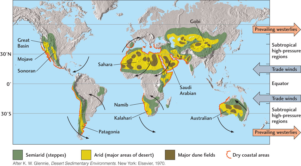
Deserts also exist at temperate latitudes—between 30° N and 50° N and between 30° S and 50° S—in regions where rainfall is low because moisture-laden winds either are blocked by mountain ranges or must travel great distances from the ocean, their source of moisture. The Great Basin and Mojave deserts of the western United States, for example, lie in rain shadows created by the western coastal mountains. The Gobi and other deserts of central Asia are so deep in the continental interior that the winds reaching them have precipitated all their ocean-derived moisture long before they arrive there.
541
Another kind of desert is found in polar regions. There is little precipitation in these cold, dry areas because the frigid air can hold little moisture. The dry valley region of southern Victoria Land in Antarctica is so dry and cold that its environment resembles that of Mars.
The Role of Plate Tectonics
In a sense, deserts are a result of plate tectonic processes. The mountains that create rain shadows are raised at convergent plate boundaries. The great distance separating central Asia from the oceans is a consequence of the size of the Asian continent, a huge landmass assembled from smaller landmasses by continental drift. Large deserts are found at low latitudes because continental drift moved continents there from higher latitudes. If, in some future plate tectonic scenario, the North American continent were to move south by 2000 km or so, the northern Great Plains of the United States and Canada would become a hot, dry desert. Something like that happened to Australia. About 20 million years ago, Australia was far to the south of its present position, and its interior had a warm, humid climate. Since then, Australia has moved northward into an arid subtropical zone, and its interior has become a desert.
The Role of Climate Change
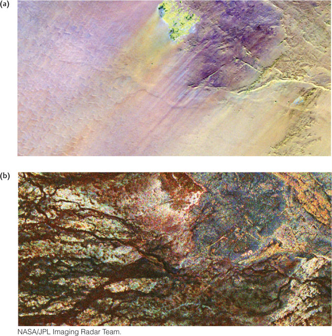
Changes in a region’s climate may transform semiarid lands into deserts, a process called desertification. Climate changes that we do not fully understand may decrease precipitation for decades or even centuries. After such a dry period, a region may return to a milder, wetter climate. Over the past 10,000 years, the climate of the Sahara appears to have oscillated between drier and wetter conditions. We have evidence from orbiting satellites that an extensive system of river channels existed there a few thousand years ago (Figure 19.16). Now dry and buried by more recent sand deposits, these ancient drainage systems carried abundant running water across the northern Sahara during wetter periods.
The Sahara may now be expanding northward (see the Practicing Geology exercise). The Desert Watch project, led by the European Space Agency, reports that over 300,000 km2 of Europe’s Mediterranean coast—an area almost as large as the state of New York, with a population of 16 million—has been enduring the longest drought in recorded history. During 2005 and 2012, fires raged along the southern Spanish coast, and temperatures set new record highs for weeks on end. Were these merely long, hot summers, or are these the initial symptoms of desertification, made worse by overpopulation and overdevelopment within the fragile ecosystems of dry landscapes?
Evidence to support the latter scenario is building. Soils have been loosened by the prolonged dryness, making them more susceptible to wind transportation and deflation. Groundwater levels have reached new lows. And there is little question that Europe is getting warmer: during the twentieth century, its average temperatures increased about 0.7°C. The 1990s marked the hottest decade since record keeping began in the mid-1800s, registering two of the five hottest years ever recorded.
542
The Role of Human Activities
Climate oscillations occur naturally in the Sahara and in other deserts, but human activities are responsible for some of the desertification occurring today. The growth of human populations in semiarid regions, along with increased agriculture and animal grazing, may result in the expansion of deserts. When population growth and periods of drought coincide, the results can be disastrous. In Spain, the greatest urban and agricultural expansion is taking place on the Mediterranean coast—the nation’s driest region. Former farmlands have been stripped of vegetation due to overfarming (up to four crops per year), which depletes water and strips soils. A tourism boom and its accompanying development are literally paving over the dry lands and desiccating the countryside that is left. In 2004, more than 350,000 new homes were built on the Mediterranean coast, many with backyard swimming pools and nearby golf courses requiring large amounts of water. In isolation, any one of these human activities might not have a negative effect. Together, however, they add up to desertification.
“Making the desert bloom,” the opposite of desertification, has been a slogan of some countries with desert lands. They irrigate on a massive scale to convert semiarid or arid areas into productive farmlands. The Central Valley of California, where many of North America’s fruits and vegetables are grown, is one example. If the waters used for irrigation contain dissolved substances (as almost all natural waters do), then, with time, these waters evaporate and deposit the dissolved substances as salts. Thus, ironically, irrigation in an arid or semiarid climate can eventually cause desertification through the slow accumulation of salts.
Desert Weathering and Erosion
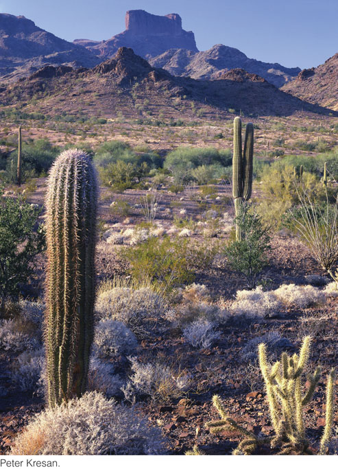
As unique as deserts are, the same geologic processes operate there as elsewhere. Physical and chemical weathering work the same way in deserts as they do everywhere, but the balance between the two processes is different: in deserts, physical weathering predominates over chemical weathering. Chemical weathering of feldspars and other silicates into clay minerals proceeds slowly because the water required for those reactions is scarce. The little clay that does form is usually blown away by strong winds before it can accumulate. Slow chemical weathering and rapid wind transportation combine to prevent the buildup of any significant thickness of soil, even where sparse vegetation binds some of the weathered particles. Thus, desert soils are thin and patchy. Sand, gravel, rock fragments of many sizes, and bare bedrock are characteristic of much of the desert surface.
543
The Colors of The Desert
The rusty, orange-brown colors of many weathered surfaces in the desert come from the ferric iron oxide minerals hematite and limonite. These minerals are produced by the slow chemical weathering of iron silicate minerals such as pyroxene. Even when present in only small amounts, they stain the surfaces of sands, gravels, and clays.
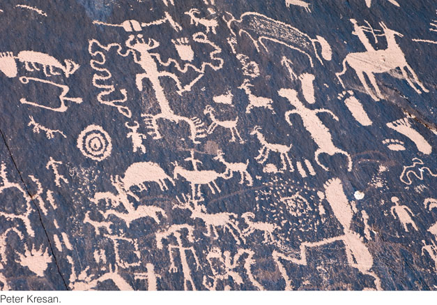
Desert varnish is a distinctive dark brown, sometimes shiny, coating found on many rock surfaces in the desert. It is a mixture of clay minerals with smaller amounts of manganese and iron oxides. Desert varnish probably forms when dew causes chemical weathering of primary minerals on an exposed rock surface to form clay minerals and iron and manganese oxides. In addition, tiny quantities of windblown dust may adhere to the rock surface. The process is so slow that Native American inscriptions scratched in desert varnish hundreds of years ago still appear fresh, with a stark contrast between the dark varnish and the light unweathered rock beneath (Figure 19.17). Desert varnish requires thousands of years to form, and some particularly ancient varnishes in North America are of Miocene age. However, recognizing desert varnish as such on ancient sandstones is difficult.
Streams: The Primary Agents of Erosion
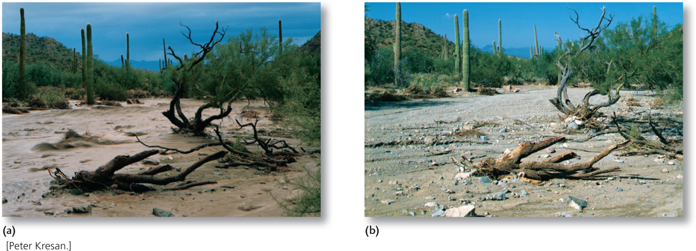
Wind plays a larger role in erosion in deserts than it does elsewhere, but it cannot compete with the erosive power of streams. Even though it rains so seldom that most streams flow only intermittently, streams do most of the erosional work in the desert when they do flow.
Even the driest desert gets occasional rain. In sandy and gravelly areas of deserts, rainfall infiltrates soil and permeable bedrock and temporarily replenishes groundwater in the unsaturated zone. There, some of it evaporates very slowly into pore spaces between particles. A smaller amount eventually reaches the groundwater table far below—in some places, as much as hundreds of meters below the surface. Desert oases form where the groundwater table comes close enough to the surface that the roots of palms and other plants can reach it.
When rain occurs in heavy cloudbursts, so much water falls in such a short time that infiltration cannot keep pace, and the bulk of the water runs off into streams. Unhindered by vegetation, the runoff is rapid and may cause flash floods along valley floors that have been dry for years. Thus, a large proportion of streamflows in deserts consist of floods (Figure 19.18a). When floods occur in deserts, they have great erosive power because little of the loose sediment is held in place by vegetation. Streams may become so choked with sediment that they look more like fast-moving mudflows. The abrasiveness of this sediment load moving at flood velocities makes desert streams efficient eroders of bedrock valleys.
Desert Sediments and Sedimentation
Deserts are composed of a diverse set of sedimentary environments. These environments may change dramatically when rain suddenly forms raging rivers and widespread lakes. Prolonged dry periods intervene, during which sediments are blown into sand dunes.
Alluvial Sediments
As sediment-laden flash floods dry up, they leave distinctive alluvial deposits on the floors of desert valleys. In many cases, a flat fill of coarse sediment covers the entire valley floor, and the ordinary differentiation of the stream into channel, natural levees, and floodplain is absent (Figure 19.18b). The sediments of many other desert valleys clearly show the intermixing of stream-deposited channel and floodplain sediments with eolian sediments. This combination of alluvial and eolian processes in the past formed extensive layers of eolian sandstones separated by channel sediments and ancient floodplain sandstones.
544
Large alluvial fans are prominent features at mountain fronts in deserts because desert streams deposit much of their sediment load on the fans (see Figure 18.26). The rapid infiltration of stream water into the permeable sediments that make up the fan deprives the stream of the water required to carry the sediment load any farther downstream. Debris flows and mudflows make up large parts of the alluvial fans of arid, mountainous regions.
Eolian Sediments
By far the most dramatic sedimentary accumulations in deserts are the sand dunes we have described above. Dune fields range in size from a few square kilometers to the “seas of sand” found on the Arabian Peninsula (see Figure 19.8). These sand seas—or ergs—may cover as much as 500,000 km2, twice the area of the state of Nevada.
Although film and television portrayals might lead one to think that deserts are mostly sand, only one-fifth of the world’s desert area is actually covered by sand (see Figure 19.15). The other four-fifths are rocky or covered with desert pavement. Sand covers only a little more than one-tenth of the Sahara, and sand dunes are even less common in the deserts of the southwestern United States.
Evaporite Sediments
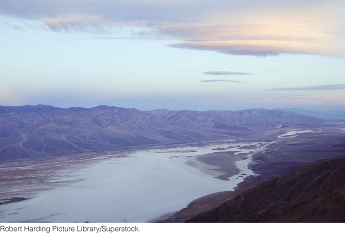
Playa lakes are permanent or temporary lakes that form in arid mountain valleys or basins where water is trapped after rainstorms (Figure 19.19). Desert streams carry large amounts of dissolved minerals, and those minerals accumulate in playa lakes. As the lake water evaporates, the minerals are concentrated and gradually precipitated. Playa lakes are sources of evaporite minerals such as sodium carbonate, borax (sodium borate), and other unusual salts. If evaporation is complete, the lakes become playas, flat beds of clay that are sometimes encrusted with precipitated salts.
Desert Landscapes
Desert landscapes are some of the most varied on Earth. Large low, flat areas are covered by playas, desert pavements, and dune fields. Uplands are rocky, cut in many places by steep stream valleys and gorges. The lack of vegetation and soil makes everything seem sharper and harsher than it would in a landscape in a more humid climate. In contrast to the rounded, soil-covered, vegetated slopes found in most humid regions, the coarse fragments of varying size produced by desert weathering form steep cliffs with masses of angular talus at their bases (Figure 19.20).
545
Much of the landscape of deserts is shaped by streams, but their valleys—called dry washes in the western United States and wadis in the Middle East—are dry most of the time. Stream valleys in deserts have the same range of profiles as valleys elsewhere. Far more of them, however, have steep walls because of the rapid erosion caused by stream flooding, combined with the lack of rainfall that might soften the slopes of the valley walls between flood events.
Desert streams are widely spaced because of the relatively infrequent rainfall. Drainage patterns in deserts are generally similar to those in other terrains, with one important difference: many desert streams die out before they can reach across the desert to join larger rivers flowing to the oceans. Most terminate at the base of alluvial fans. Damming by dunes or confinement within closed valleys with no outlet may lead to the development of playa lakes.
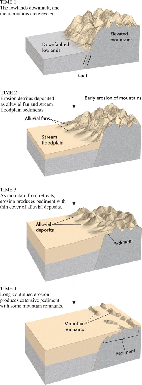
A special type of eroded bedrock surface, called a pediment, is a characteristic landform of the desert. Pediments are broad, gently sloping platforms of bedrock left behind as a mountain front erodes and retreats from its valley (Figure 19.21). The pediment forms like an apron around the base of the mountains as thin alluvial deposits of sand and gravel accumulate. Long-continued erosion eventually forms an extensive pediment below a few mountain remnants (Figure 19.22). A cross section of a typical pediment and its mountains would reveal a fairly steep mountain slope abruptly leveling into the gentle pediment slope. Alluvial fans deposited at the lower edge of the pediment merge with the sedimentary fill of the valley below the pediment.
546
There is much evidence that pediments are formed by running water, which cuts and forms the pediment surface as well as transporting and depositing sediments to create an apron of alluvial fans. At the same time, the mountain slopes at the head of the pediment maintain their steepness as they retreat, instead of becoming the rounded, gentler slopes found in humid regions. We do not know how specific rock types and erosional processes interact in an arid environment to keep the slopes steep as the pediment is enlarged.
547