Practicing Geology Exercise
Can We Predict the Extent of Desertification?
In regions of the world with arid to semiarid climates, farmlands and grazing lands are being lost to desertification at an alarming rate. Two questions are important to land managers hoping to prevent further degradation of environmentally sensitive dry lands: First, what processes are leading to degradation and desertification? Second, how widespread is this desertification likely to be?
Desertification occurs whenever a nondesert area starts to exhibit the characteristics of a true desert. The term was coined by the United Nations in 1977 to describe changes that were particularly evident in northern Africa at that time. Over the past 50 years, a semiarid area the size of Texas at the southern edge of the Sahara, called the Sahel, has started to become desert. The same fate now threatens more than one-third of the African continent. Desertification is most pronounced in northern Africa, but affects every continent except Antarctica. North Americans should be aware that the areas that fringe the deserts of the southwestern United States may also be susceptible to desertification if not managed properly.
The main cause of desertification is not drought, but mismanagement of land, including overgrazing, overly intensive cultivation, and felling of trees and brushwood for fuel. The processes that lead to desertification include erosion of soil by both water and wind, long-term reductions in the amount or diversity of natural vegetation, and, on irrigated farmlands, the accumulation of salts in soils by evaporation of groundwater used for irrigation.
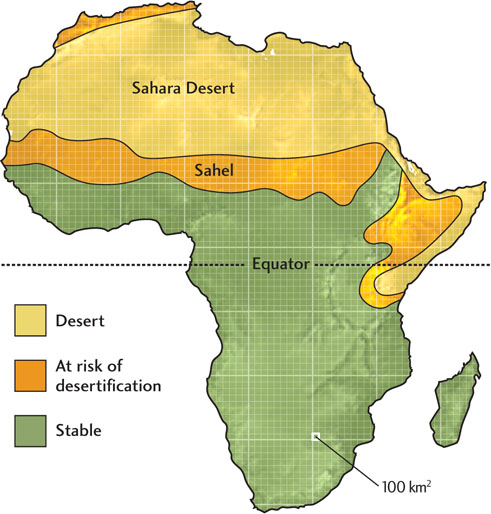
The accompanying figure is a regional map of northern Africa showing the current extent of the Sahara. It also shows the regions adjacent to the desert that currently support agriculture, but which are highly susceptible to desertification. The grid superimposed on the map subdivides it into squares, each of which represents 100 km2. We can use this grid to measure the minimum area that is susceptible to desertification.
- 1. Find the areas on the map that have been identified as susceptible to desertification.
- 2. Count the grid squares that correspond to these identified areas. Count only those squares that contain just the areas that are susceptible to desertification—not those squares that include boundaries between those areas and the more environmentally stable adjacent land. This way you will obtain a minimum estimate of the potential increase in desert area.
- 3. Find the area by multiplying the total number of squares and the value for each square. Remember that each square represents 100 km2.
area of desertification =
(total number of squares) × 100 km2 (area per square)This result is the minimum area of desertification because the squares that include boundaries between susceptible lands and environmentally stable lands were not included in our calculation.
BONUS PROBLEM: Now, try the calculation yourself, but this time including the squares that include the boundaries. The result will provide a sense of what the maximum area of desertification might be.