Continental Margins
Offshore, beyond the shoreline, lies the continental shelf. At its edge is a continental slope that descends more or less steeply into the depths of the ocean. At the foot of the slope is a continental rise, a gently sloping apron of muddy and sandy sediments extending to the flat abyssal plain at the bottom of the ocean basin (Figure 20.18).
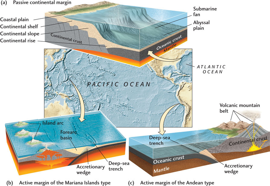
The shorelines, shelves, and slopes of the continents are together called continental margins. There are two basic types of continental margins, passive and active. A passive margin is formed when seafloor spreading carries a continent far from a plate boundary; the eastern margins of North America and Australia and the western margin of Europe are examples. The name implies quiescence: volcanoes are absent, and earthquakes are few and far between. In contrast, active margins, such as the western margin of South America, result from subduction near a continent. Occasionally, active margins are associated with transform faulting. Volcanic activity and frequent earthquakes give these continental margins their name. Active margins at subduction zones include an offshore trench and an active volcanic island arc or mountain belt.
571
The continental shelves of passive margins consist of essentially flat-lying shallow-water sediments, both terrigenous and carbonate, several kilometers thick (Figure 20.18a). Although the same kinds of sediments can be found on the shelves of active margins, they are more likely to be structurally deformed and to include ash and other volcanic materials as well as deep-sea sediments. Most active margins on the eastern side of the Pacific Ocean (for example, west of the Andes in South America) feature a narrow continental shelf that falls off sharply into a deep-sea trench without much accumulation of sediments (Figure 20.18c). Those on the western side of the Pacific (for example, off the Mariana Islands) have a wider shelf lying between the continent and the subduction zone. The trench forms a substantial forearc basin, where thick sequences of sediment are deposited (Figure 20.18b). Most of these sediments come from erosion of the uplifted island arc, but some sediments are scraped off the subducting oceanic crust, forming an accretionary wedge.
The Continental Shelf
The continental shelf is one of the most economically valuable parts of the ocean. Georges Bank off New England and the Grand Banks of Newfoundland, both on the continental shelf off North America, are among the world’s most productive fishing grounds. Recently, oil-drilling platforms have been used to extract huge quantities of oil and gas from beneath continental shelves, especially off the Gulf Coast of Louisiana and Texas.
Because continental shelves lie at shallow depths, they are subject to emergence and submergence as a result of changes in sea level. During the Pleistocene ice ages, all the shelves now at depths of less than 100 m were above sea level, and many of their features were formed then. Shelves at high latitudes were glaciated, and thus have an irregular topography of shallow valleys, basins, and ridges. Those at lower latitudes are more regular, cut by occasional stream valleys.
The Continental Slope and Rise
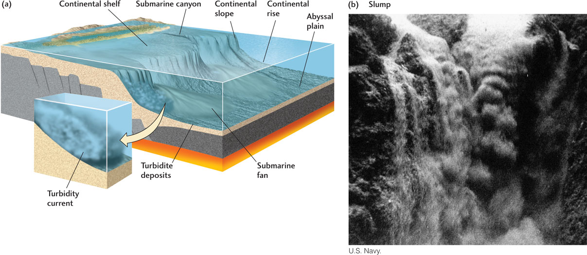
The waters of the continental slope and rise are too deep for the seafloor to be affected by waves and tidal currents. As a consequence, sediments that have been carried across the continental shelf by waves and tides come to rest as they are draped over the continental slope. Geologists have observed signs of sediment slumping and erosional scars in the form of gullies and submarine canyons on continental slopes. In addition, deposits of sand, silt, and mud on both the continental slope and the continental rise indicate active transport of sediments into deeper waters. For some time, geologists puzzled over what kind of current might cause both erosion and sedimentation on the slope and rise at such great depths.
The answer proved to be turbidity currents: turbulent flows of muddy water down the slope (Figure 20.19). Turbidity currents can both erode and transport sediment. They begin when sediments draped over the edge of the continental shelf slump onto the continental slope. Such a sudden submarine landslide throws mud into suspension, creating a dense, turbid layer of water. Because of its suspended load of mud, the turbid water is denser than the overlying clear water and flows beneath it, accelerating down the slope. As the turbidity current reaches the foot of the slope, it slows. Some of the coarser sandy sediment starts to settle out, often forming a submarine fan—a deposit something like an alluvial fan on land. Stronger turbidity currents may continue across the continental rise, cutting channels into submarine fans. Where these currents reach the abyssal plain, they spread out and come to rest in graded beds of sand, silt, and mud called turbidites.
According to current research, submarine landslides that start turbidity currents are common. Some of them may be huge. One slide generated 8- to 10-m-thick turbidites—consisting of 500 km3 of sediments—over a large area of the western Mediterranean. Submarine slides may occur spontaneously or be triggered by an earthquake. They may also be caused by thawing of methane-water ices: crystalline solids composed of methane and water. Methane-water ices are stable at the high pressures and low temperatures of many large areas of the oceans. In deeply buried sediments, they turn into methane gas (see Chapter 11). If sea level is lowered, as it is during ice ages, the pressure at the ocean bottom is reduced, and the ices may gasify, triggering a landslide. The quantities of gas produced are enormous, and geologists have speculated about the possibility of exploiting these subsea methane-water ices as fuels.
Submarine Canyons
Submarine canyons are deep valleys eroded into the continental shelf and slope. They were discovered near the beginning of the twentieth century and were first mapped in detail in 1937. At first, some geologists thought they might have been formed by rivers. There is no question that the shallower parts of some canyons were river channels during periods when sea level was low. But this hypothesis could not provide a complete explanation. Most of the canyon floors are thousands of meters deep. Even at the minimum sea levels of the Pleistocene ice ages, rivers could have eroded the seafloor only to a depth of about l00 m.
572
Although other types of currents have been proposed, turbidity currents are now the favored explanation for the deeper parts of submarine canyons (see Figure 20.19). Evidence supporting this conclusion comes in part from a comparison of deposits within modern submarine canyons with well-preserved similar deposits of the past, particularly turbidites deposited in canyons and channels on submarine fans.