Glacial Landscapes
The movement of glaciers is responsible for the immense amount of geologic work done by ice: erosion, transportation, and sedimentation. Just as you cannot see your own footprint in the sand while your foot is covering it, you cannot see the effects of an active glacier at its base or sides. Only when the ice melts is its geologic work revealed. We can infer the physical processes driven by moving ice from the topography of formerly glaciated areas and the distinctive landforms left behind.
Glacial Erosion and Erosional Landforms
Ice is a far more efficient agent of erosion than water or wind. A valley glacier only a few hundred meters wide can tear up and crush millions of tons of bedrock in a single year. The ice carries this heavy load of sediment to the ice front, where it is dropped as the ice melts. The total amount of sediment deposited in the world ocean per year has been several times larger during recent ice ages than during interglacial periods.
599
21.1: Isostasy and Sea Level Change
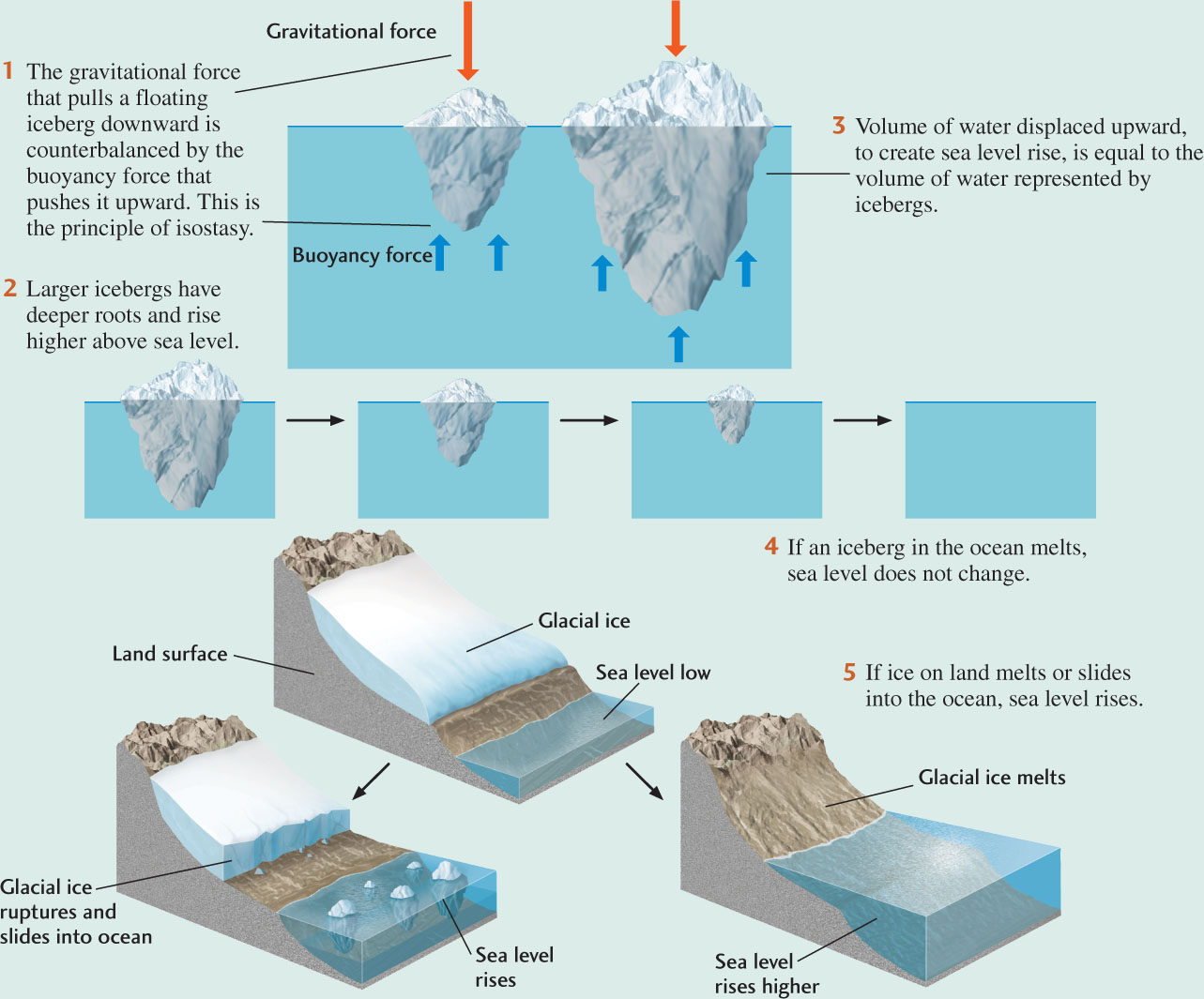
If the ice shelves around Antarctica continue to collapse, will sea level rise? It turns out that even if all of Earth’s ice shelves were to break off into the ocean over the next few years, sea level wouldn’t change much at all. The reason is related to the principle of isostasy, which we discussed in Chapter 14. Ice shelves, like icebergs, float on ocean waters. When they melt, there is no change in sea level for the same reason that, when ice cubes in your drink melt, the level of the liquid in your glass doesn’t change.
The buoyancy of icebergs and ice shelves results from the fact that the volume of the ice below the sea surface weighs less than the volume of water it displaces. This buoyancy force counteracts the gravitational force that pulls down on the iceberg. Bigger icebergs stand higher above the sea surface, but also have a deeper root below the surface that provides greater buoyancy. When an iceberg melts, there is no change in sea level, because the water volume resulting from the melting exactly equals the water volume that had been displaced by the iceberg.
In contrast, when glaciers on land melt, most of the water flows into the ocean, increasing the ocean volume and thereby raising the sea level. And when glaciers on land flow into the ocean, the water in the oceans is displaced by the icebergs they shed, which also raises sea level.
Therefore, the destruction of an ice shelf will raise sea level only if part of the ice shelf that was grounded on land slides into the ocean. In that case, the weight of the ice is no longer supported by the continent, but rather by the seawater it displaces, causing a sea-level rise.
600
At its base and sides, a glacier engulfs jointed, cracked blocks of rock, breaks off pieces, and grinds them against the bedrock below. This grinding action fragments rocks into a great range of sizes, from boulders as big as houses to fine silt- and clay-sized material called rock flour. Rock flour is subject to rapid chemical weathering because of its small size and correspondingly large surface area. Where glacial debris is still encased in ice and the ground is overlain by thick ice, chemical weathering is slower than on ice-free terrain. When rock flour is freed from the ice at the melting edge of a glacier, it dries out and is blown into the air as dust. As we saw in Chapter 19, wind can carry this dust over great distances, ultimately depositing it as the loess that is so common in formerly glaciated regions.
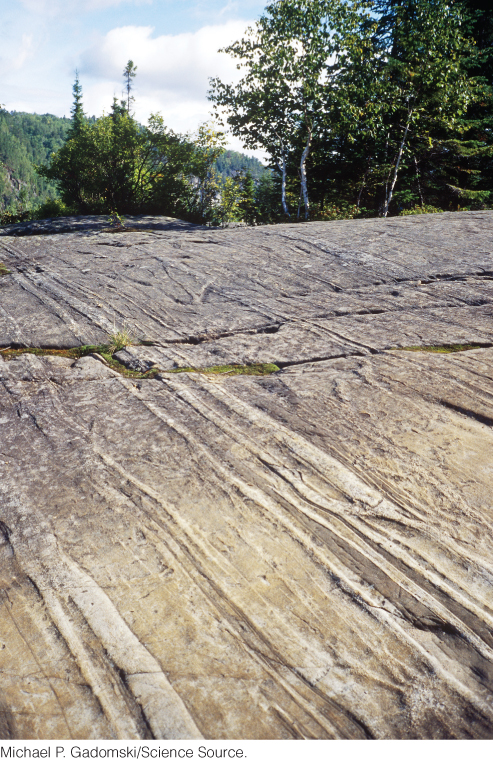
As a glacier drags rocks along its base, those rocks scratch or groove the bedrock beneath it. Such abrasions are termed striations. The orientation of striations shows us the direction of ice movement—an especially important factor in the study of continental glaciers, which lack obvious valleys. By mapping striations over wide areas formerly covered by a continental glacier, we can reconstruct the glacier’s flow patterns (Figure 21.14).
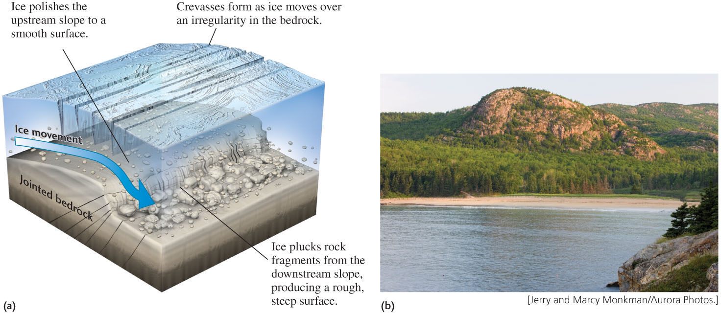
Advancing glacial ice smooths small hills of bedrock—known as roches moutonnées (“sheep rocks”) for their resemblance to a sheep’s back—on their upstream side and plucks them to a rough, steep slope on their downstream side (Figure 21.15). These contrasting slopes indicate the direction of ice movement.
601
A flowing valley glacier carves a series of erosional landforms as it flows from its origin to its lower edge (Figure 21.16). At the head of the valley, the plucking and tearing action of the ice tends to carve out an amphitheater-like hollow called a cirque, usually shaped like half of an inverted cone. With continued erosion, cirques at the heads of adjacent valleys gradually meet to form sharp mountaintops, or horns, and jagged crests called arêtes along the divide. As the glacier flows down from its cirque, it excavates a new valley or deepens an existing stream valley, creating a characteristic U-shaped valley. Glacial valley floors are wide and flat and have steep walls, in contrast to the V-shaped valleys of many mountain streams (see Chapter 18).
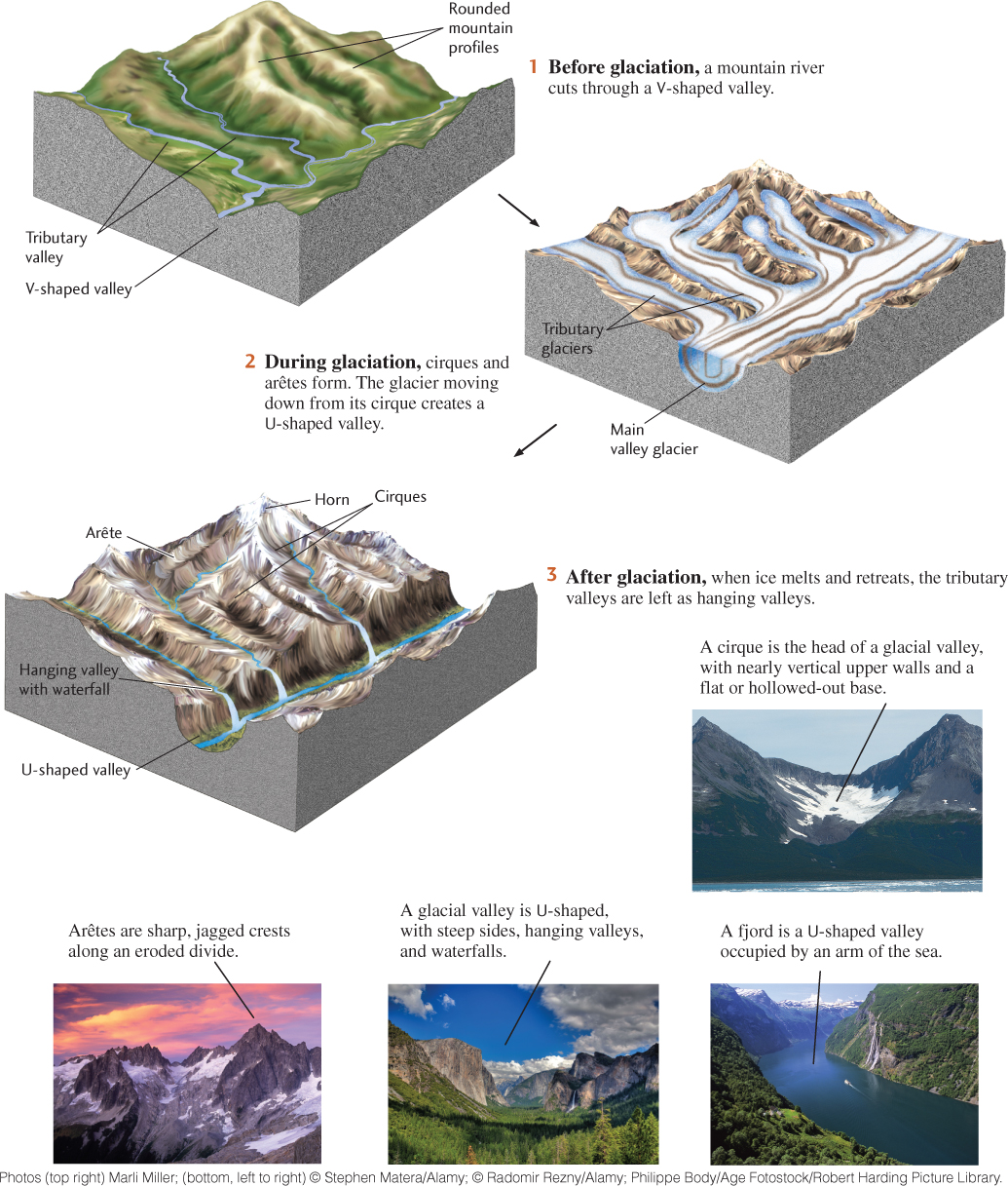
602
Glaciers and streams also differ in how their tributaries form junctions. Although the ice surface is level where a tributary glacier joins a main valley glacier, the floor of the main valley may be carved much more deeply than that of the tributary valley. When the ice melts, the tributary valley is left as a hanging valley—one whose floor lies high above the main valley floor (see Figure 21.16). After the ice is gone and streams occupy the valleys, the junction is marked by a waterfall as the stream in the hanging valley plunges over the steep cliff separating it from the main valley below.
Valley glaciers at coastlines may erode their valley floors far below sea level. When the ice retreats, these steep-walled valleys—which still maintain a U-shaped profile—are flooded with seawater (see Figure 21.16). These arms of the sea carved out by glaciers, called fjords, create the spectacular rugged scenery for which the coasts of Alaska, British Columbia, Norway, and New Zealand are renowned.
603
Glacial Sedimentation and Sedimentary Landforms
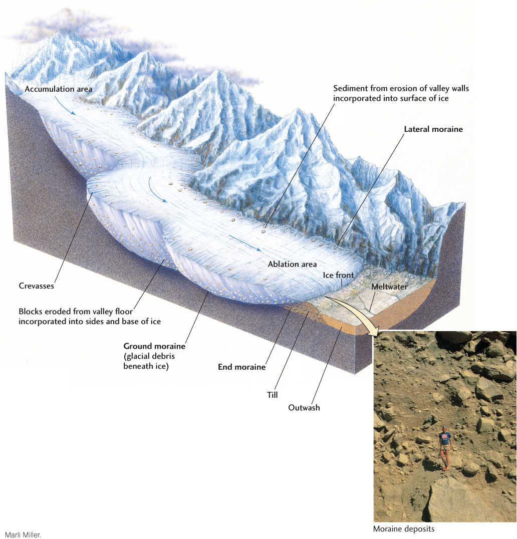
Glaciers transport eroded rock materials of all kinds and sizes downstream, eventually depositing them where the ice melts. Ice is a very effective transport agent because the material it picks up does not settle out like the load of sediment carried by a stream. Like water and wind currents, flowing ice has both a competence (an ability to carry particles of a certain size) and a capacity (a total amount of sediment that it can transport). Ice has extremely high competence: it can carry huge blocks many meters in diameter that no other transport agent could budge. Ice also has a tremendous capacity. Some glacial ice is so full of rock material that it is dark and looks like sediment cemented with ice.
When glacial ice melts, it deposits a poorly sorted, heterogeneous load of boulders, pebbles, sand, and clay. A wide range of particle sizes is the characteristic that differentiates glacial sediments from the much better sorted material deposited by streams and winds. This heterogeneous material puzzled early geologists, who were not aware of its glacial origins. They called it drift because it seemed to have drifted in somehow from other areas. The term drift is now used for all material of glacial origin found anywhere on land or beneath the ocean.
Some drift is deposited directly by melting ice. This unstratified and poorly sorted sediment is known as till, and it may contain all sizes of rock fragments from clay to boulders (Figure 21.17). The large boulders often contained in till are called erratics because of their seemingly random composition, often very different from that of local rocks.
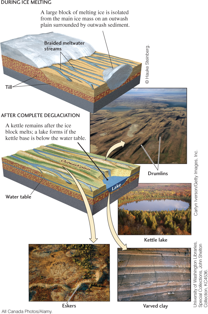
Other deposits of drift are laid down as the ice melts and releases water and sediment. Meltwater flowing in tunnels within and beneath the ice and in streams at the ice front may pick up, transport, and deposit some of the drift. Deposits of drift may trap some of the meltwater, causing it to pool and form lakes. Like any other waterborne sediment, the drift transported by meltwater is stratified and well sorted and may be cross-bedded. Drift that has been picked up and distributed by melt-water streams is called outwash, and it often forms broad sedimentary plains downstream of melting glaciers, known as outwash plains. Strong winds can transport fine-grained material from outwash plains over long distances and deposit it as loess.
Glacial sedimentary sequences can be identified by the distinctive textures of interbedded tills, outwash, and loess, as well as by striations and other erosional forms that may be preserved. Mapping of such sequences has allowed geologists to infer many glaciations of past geologic times.
Ice-Laid Deposits
A moraine is an accumulation of rocky, sandy, and clayey material carried by glacial ice or deposited as till. There are many types of moraines, each named for its position with respect to the glacier that formed it (Table 21.1). One of the most prominent in size and appearance is an end moraine, formed at the ice front. As the ice flows steadily downstream, it brings more and more sediment to its melting edge. The unsorted material accumulates there as a hilly ridge of till. Regardless of their shape or location, moraines of all kinds consist of till. Figure 21.17 illustrates the processes by which various kinds of moraines form as a glacier works its way through a valley.
| Type of Moraine | Location with Respect to Ice Front | Comments |
|---|---|---|
| End moraine | At ice front | After glacier melts, seen as ridge parallel to former ice front |
| Terminal moraine | At ice front marking farthest advance of ice | Type of end moraine |
| Lateral moraine | Along edge of glacier where it scrapes side walls of valley | Heavy sediment load eroded from valley walls; when ice melts, seen as ridge parallel to valley walls |
| Medial moraine | Formed as two joined glaciers merge their lateral moraines below junction | Inherits its sediment load from lateral moraines that formed it; forms ridge parallel to valley walls |
| Ground moraine | Beneath the ice as a layer of glacial debris | Ranges from thin and patchy to a thick blanket of tills |
604
Some continental glacial terrains display prominent landforms called drumlins: large, streamlined hills of till and bedrock that parallel the direction of ice movement (Figure 21.18). Drumlins, usually found in clusters, are shaped like long, inverted spoons with the gentlest slopes on the downstream sides. They may be 25 to 50 m high and a kilometer long. Drumlins form when the sediment-rich layer at the base of a glacier encounters a knob of bedrock or other obstacle and the excess pressure squeezes out water and drops the sediment.
Water-Laid Deposits
Deposits of outwash by glacial meltwater take a variety of forms. Kames are small hills of sand and gravel created when drift fills a hole in a glacier and is left behind when the glacier recedes. Some kames are deltas built into a lake at the ice front. When the lake drains, the deltas are preserved as flat-topped hills. Kames are often exploited as commercial sand and gravel pits.
Eskers are long, narrow, winding ridges of sand and gravel found in the middle of ground moraines (see Figure 21.18). They may run for kilometers in a direction roughly parallel to the direction of ice movement. The origin of eskers is suggested by the well-sorted, water-laid character of their materials and the sinuous, channel-like courses of the ridges themselves: eskers are deposited by meltwater streams flowing in tunnels along the bottom of a melting glacier.
605
Kettles are hollows or undrained depressions that often have steep sides and may be occupied by ponds or lakes. Modern glaciers, which may leave behind huge isolated blocks of ice in outwash plains as they melt, offer the clue to the origin of kettles. A block of ice a kilometer in diameter may take 30 years or more to melt. During that time, the melting block may be partly buried by outwash sand and gravel carried by meltwater streams—usually braided—coursing around it. By the time the block has melted completely, the ice front has retreated so far that little outwash reaches the area. The sand and gravel that formerly surrounded the block of ice now surround a depression. If the bottom of the kettle lies below the groundwater table, a lake will form.
Varves are formed when valley glaciers deposit silts and clays on the bottom of a lake in a series of alternating coarse and fine layers (see Figure 21.18). A varve is a pair of layers formed in one year by seasonal freezing of the lake surface. In summer, when the lake is free of ice, coarse silt is laid down by abundant meltwater streams flowing from the glacier into the lake. In winter, when the surface of the lake is frozen, the finest clays settle, depositing a thin layer on top of the coarse summer layer.
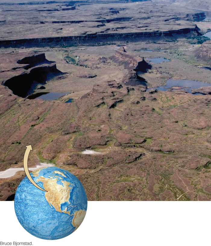
Some lakes formed by continental glaciers were huge, many thousands of square kilometers in area. The till dams that created these lakes were sometimes breached and carried away at a later time, causing the lakes to drain rapidly and creating huge floods. In eastern Washington State, an area called the Channeled Scablands (Figure 21.19) is covered by broad, dry stream channels, relics of torrential floodwaters draining from Lake Missoula, a large glacial lake, now completely emptied. From the giant ripples, sandbars, and coarse gravels found there, geologists have estimated that this flood discharged 21 million cubic meters of water per second, flowing as fast as 30 m/s. For comparison, the velocities of ordinary river flows are measured in fractions of a meter per second, and the discharge rate of the Mississippi River in full flood is less than 50,000 m3/s.
606
Permafrost
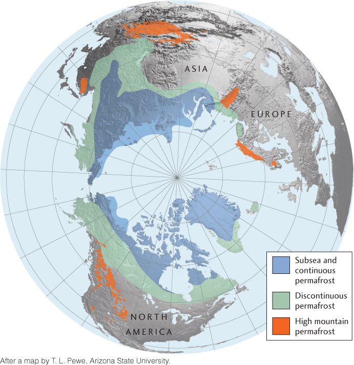
The ground is always frozen in very cold regions where the summer temperature never gets high enough to melt more than a thin surface layer. Perennially frozen soil, or permafrost, today covers as much as 25 percent of Earth’s total land area. In addition to the soil itself, permafrost includes aggregates of ice crystals in layers, wedges, and irregular masses. The proportion of ice to soil and the thickness of the permafrost vary from region to region. Permafrost is defined solely by temperature, not by soil moisture content, overlying snow cover, or location: any rock or soil remaining at or below 0°C for 2 or more years is considered permafrost.
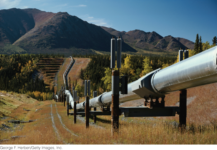
In Alaska and northern Canada, permafrost may be as thick as 300 to 500 m. The ground below the permafrost layer, insulated from the bitterly cold temperatures at the surface, remains unfrozen. It is warmed from below by Earth’s internal heat. Permafrost is a difficult material to handle in engineering projects—such as roads, building foundations, and pipelines—because it melts as it is excavated. The meltwater cannot infiltrate the still-frozen soil below the excavation, so it stays at the surface, waterlogging the soil and causing it to creep, slide, and slump. Engineers decided to build part of the Trans-Alaska pipeline above ground when an analysis showed that the pipeline would thaw the permafrost around it in some places and lead to unstable soil conditions (Figure 21.20).
Permafrost covers about 82 percent of Alaska and 50 percent of Canada, as well as a large proportion of Siberia (Figure 21.21). Outside the polar regions, it is present in high mountainous areas such as the Tibetan Plateau. Permafrost extends downward several hundred meters in shallow marine areas off the Arctic coasts, presenting difficult engineering problems for offshore oil drillers.