Landforms: Features Sculpted by Erosion and Sedimentation
Streams, glaciers, and wind leave their marks on Earth’s surface in a variety of landforms: rugged mountain slopes, broad valleys, floodplains, dunes, and many others. The scale of landforms ranges from regional to very local. At the largest scale (tens of thousands of kilometers), mountain belts form topographic walls along the boundaries of lithospheric plates. At the smallest scale (meters), the topography of an individual outcrop may be shaped by differential weathering of the rocks of differing hardnesses that compose it. This section focuses mostly on the regional-scale features that define the overall topography of Earth’s surface.
Mountains and Hills
We have used the word mountain many times in this textbook, yet we can define it no more precisely than to say that a mountain is a large mass of rock that projects well above its surroundings. Most mountains are found with others in ranges, where peaks of various heights are easier to distinguish than distinct separate mountains (Figure 22.6). Mountains that rise as single peaks above the surrounding lowlands are usually isolated volcanoes or erosional remnants of former mountain ranges.

622
We distinguish between mountains and hills only by size and custom. Landforms that would be called mountains in regions of overall lower elevation are called hills in regions of high elevation. In general, however, landforms more than several hundred meters above their surroundings are called mountains.
Mountains are direct or indirect manifestations of plate tectonic activity. The more recent the activity, the more likely the mountains are to be high. The Himalaya, the highest mountains in the world, are also among the youngest. The steepness of the slopes in mountainous and hilly areas generally correlates with elevation and relief. The steepest slopes are usually found on high mountains in areas of high relief. The slopes of mountains in areas of lower elevation and relief are less steep and rugged. As we will see later in this chapter, the relief of a mountain range depends greatly on how much the bedrock has been incised by glaciers and streams relative to the amount of tectonic uplift.
623
Plateaus
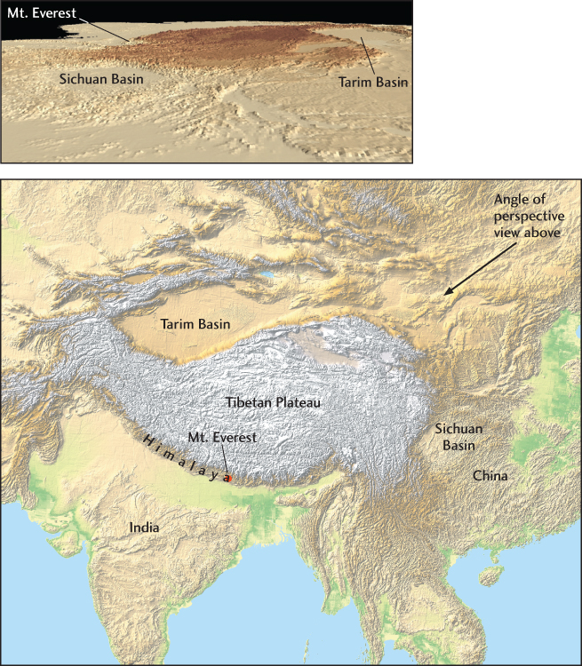
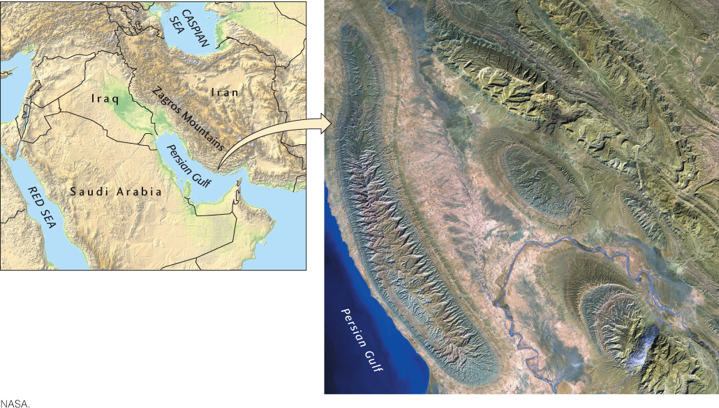
A plateau is a large, broad, flat area of appreciable elevation above the neighboring terrain. Most plateaus have elevations of less than 3000 m, but the Altiplano of Bolivia lies at an elevation of 3600 m, and the extraordinarily high Tibetan Plateau, which extends over an area of 1000 km by 5000 km (well over half the size of the United States), has an average elevation of almost 5000 m (Figure 22.7). Plateaus form where tectonic activity produces regional uplift.
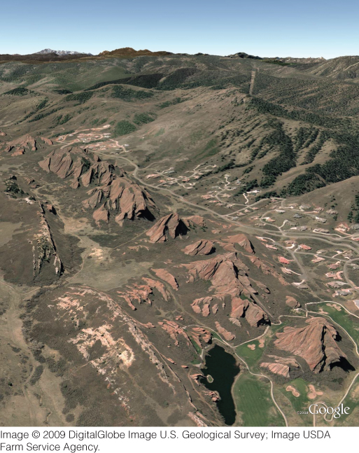
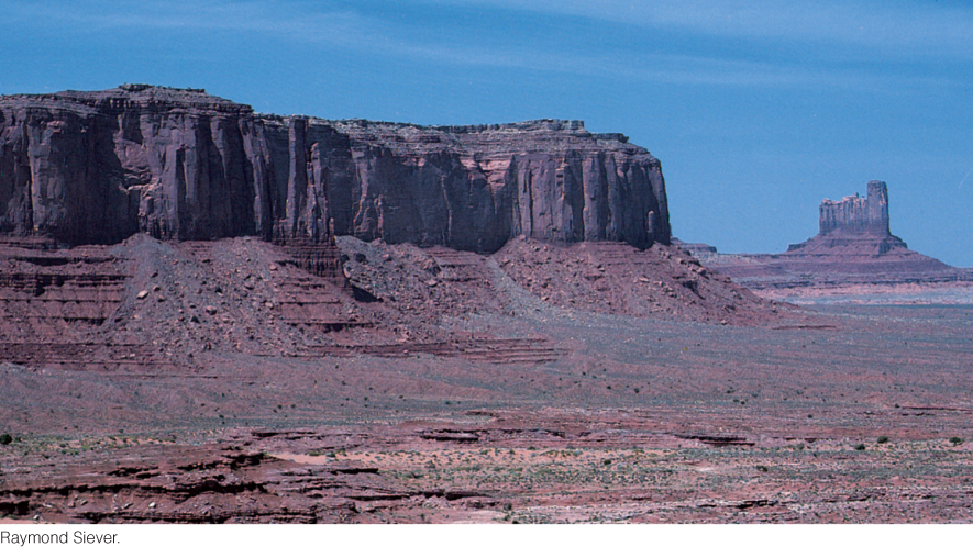
Smaller plateau-like features may be called tablelands. In the western United States, a small, flat, elevated landform with steep slopes on all sides is called a mesa (from the Spanish word for “table”) (Figure 22.8). Mesas result from differential weathering of bedrock of varying hardness.
Stream Valleys
Observations of stream valleys in various regions led to one of the important early theories of geology: the idea that stream valleys were created through erosion by the streams that flowed in them. Geologists could see that the sedimentary rock formations on one side of a valley matched the formations on the opposite side. Such observations led them to conclude that the formations had once been deposited as continuous beds of sediment, but that the stream had removed enormous quantities of the original formation by breaking up the rock and carrying it away.
How a stream erodes soil and rock depends on its stream power—which is the product of its slope and its discharge—balanced by the streambed’s ability to resist erosion—which is the product of the volume and the particle size of the sediment in the stream channel (Figure 22.9). If stream power is high enough to wash away the sediment, resistance to erosion is mainly a function of bedrock hardness.
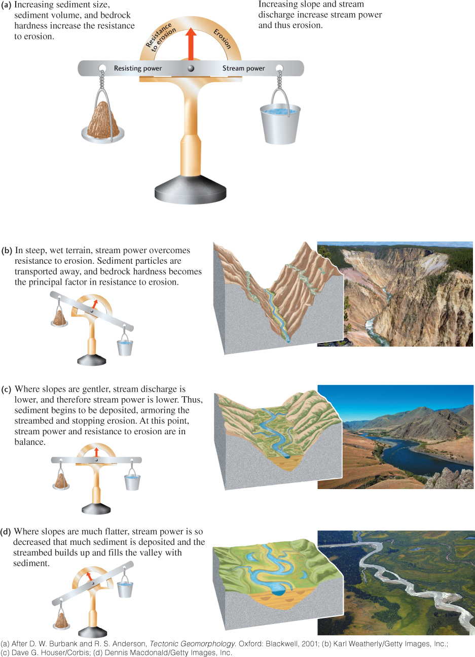
As it turns out, rates of bedrock erosion increase dramatically as stream power increases. On most days, a flowing stream accomplishes little erosion because discharge, and thus stream power, is low. However, on the rare days when discharge (and thus stream power) is very high, erosion rates can be dramatically high. This relationship illustrates a fundamental characteristic shared by many of Earth’s geosystems: large, rare events often create much more change than small, frequent ones.
Three principal processes erode bedrock in mountainous terrain. The first is abrasion of the bedrock by suspended and saltating sediment particles moving along the bottom and sides of the channel (see Chapter 18). Second, the drag force of the current itself abrades the bedrock as it plucks rock fragments from the channel. Third, at higher elevations, glacial erosion forms valleys that can then be occupied by streams. Determining the relative importance of these three processes in mountainous terrain is one way geologists can distinguish between the influences of climate and of plate tectonic processes on landscape development (see Practicing Geology exercise).
624
625
Stream valleys have many names—canyons, gulches, arroyos, gullies—but all have the same general geometry. A vertical cross section through a young mountain stream valley with little or no floodplain has a simple V-shaped profile (Figure 22.9b). A broad, low stream valley with a wide floodplain has a cross section that is more open, but is still distinct from the U-shaped profile of a glacial valley. Regions with different topographies and types of bedrock produce stream valleys of varying shapes and widths (Figure 22.9b–d). Valleys range from the narrow gorges of erosion-resistant mountain belts to the wide, shallow valleys of easily eroded plains. Between these extremes, the width of a valley generally corresponds to the erosional state of the region. Valleys are somewhat broader in mountains that have begun to be lowered and rounded by erosion and are much broader in low-lying hilly topography.
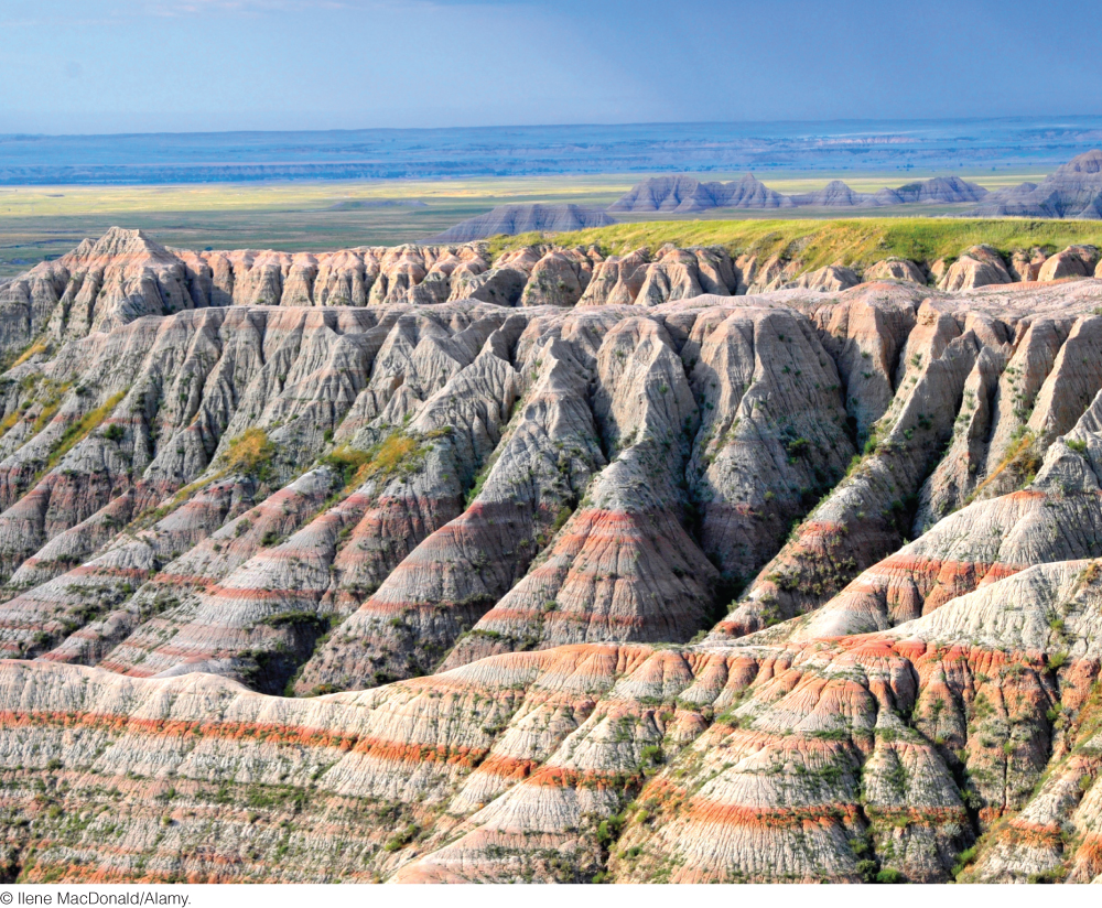
A badland is a deeply gullied landscape resulting from the rapid erosion of easily erodible shales and clays (Figure 22.10). Virtually the entire area is a proliferation of gullies and valleys, with little flat land between them.
626
Structurally Controlled Ridges and Valleys
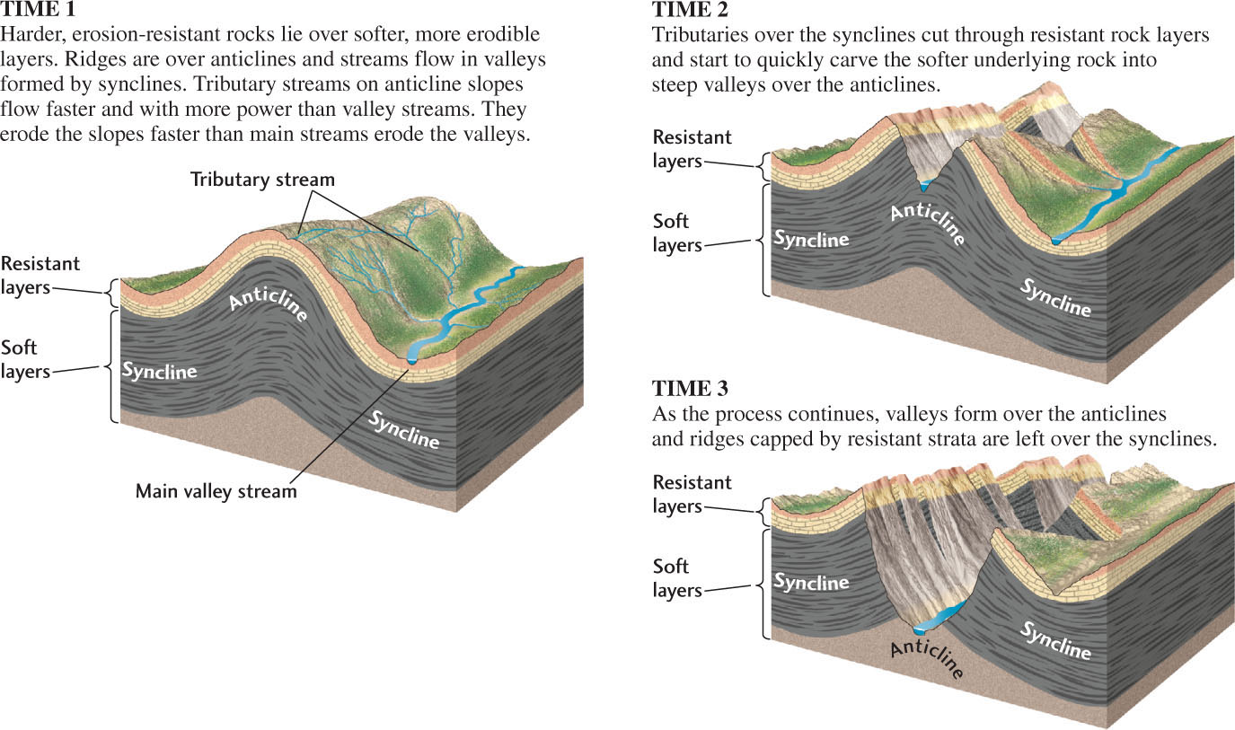
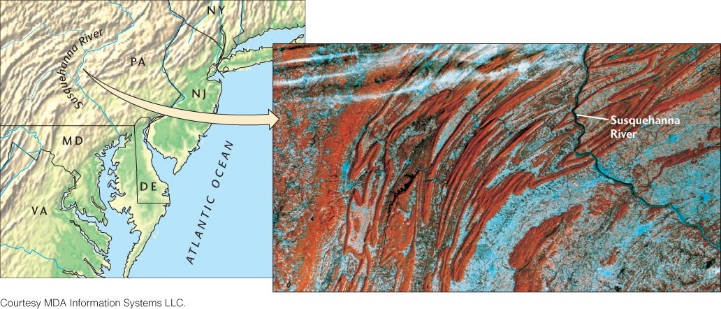
In young mountain belts, during the early stages of tectonic folding and uplift, the upward folds (anticlines) form ridges and the downward folds (synclines) form valleys (Figure 22.11). As weathering and erosion begin to predominate and gullies and valleys bite deeper into the underlying geologic structures, the topography may become inverted, so that anticlines form valleys and synclines form ridges. This happens where the rocks—typically sedimentary rocks such as limestones, sandstones, and shales—exert strong control on the topography by their variable resistance to erosion. If the rocks beneath an anticline are easily erodible, as shales are, the core of the anticline may be eroded to form an anticlinal valley (Figure 22.12). In a region that has been eroded for many millions of years, a pattern of linear anticlines and synclines produces a series of ridges and valleys such as those of the Valley and Ridge province of the Appalachian Mountains (Figure 22.13).
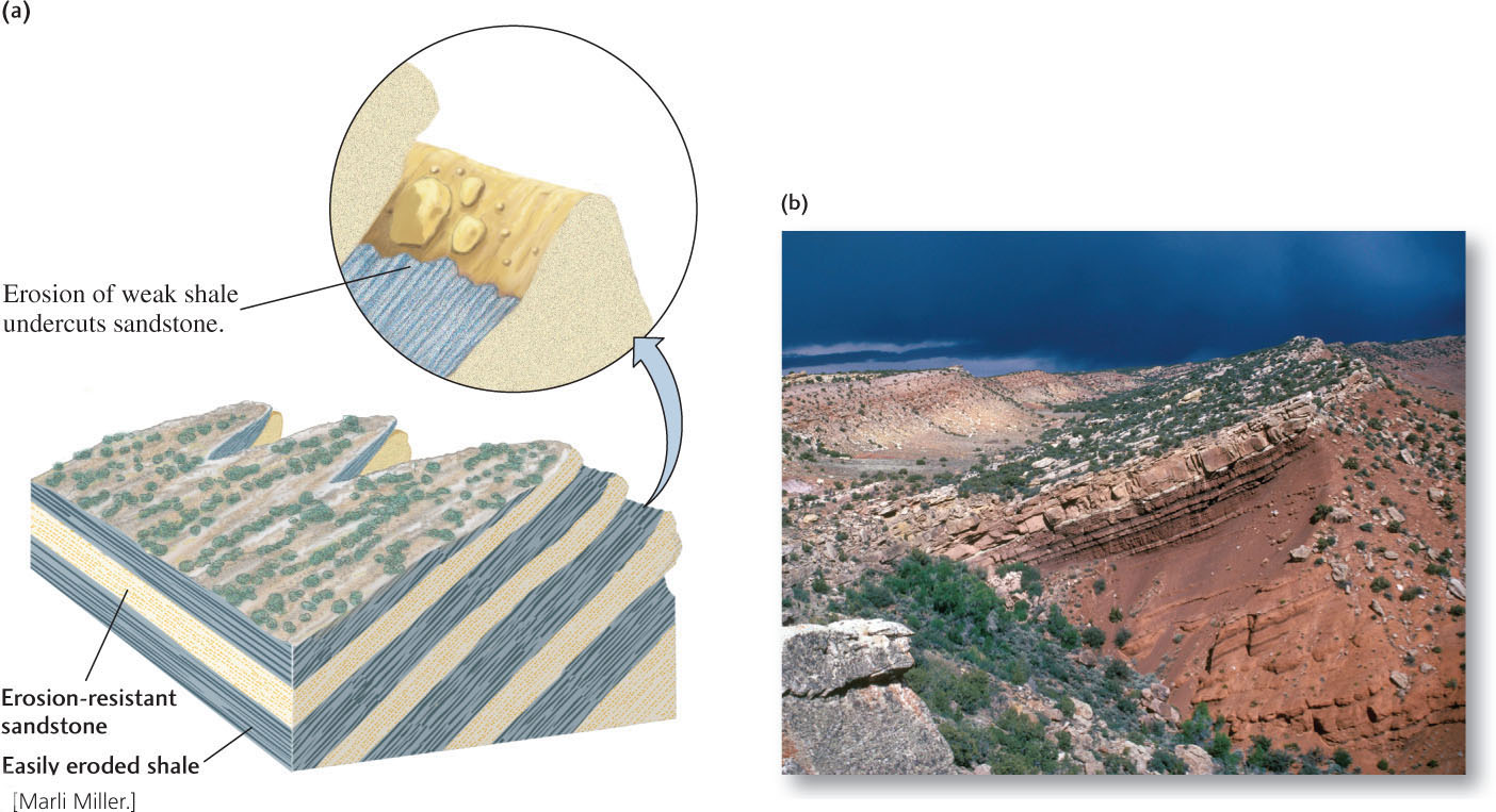
Structurally Controlled Cliffs
The folds and faults produced by deformation during mountain building leave their marks on Earth’s surface in other ways as well. Cuestas are asymmetrical ridges that form in a tilted and eroded series of beds with alternating resistance to erosion. One side of a cuesta has a long, gentle slope determined by the dip of an erosion-resistant bed. The other side is a steep cliff formed at the edge of the resistant bed where it is undercut by erosion of a weaker bed beneath it (Figure 22.14). Much more steeply dipping or vertical beds of hard strata erode more slowly to form hogbacks: steep, narrow, more or less symmetrical ridges (Figure 22.15). Fault scarps are steep cliffs produced by nearly vertical faults in which one side rises higher than the other (see Figure 7.9).