How Interacting Geosystems Control Landscapes
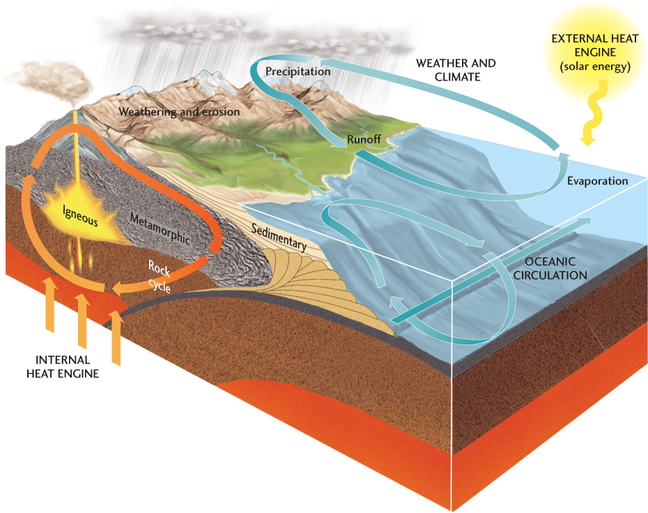
Broadly speaking, the interaction of Earth’s internal and external heat engines controls the development of landscapes. Earth’s internal heat engine drives plate tectonic processes, which elevate mountain belts and give rise to volcanoes. Earth’s external heat engine, powered by the Sun, drives the climate system, and thus controls the processes at Earth’s surface that wear away mountains and fill basins with sediment. Solar radiation powers the atmospheric circulation that produces Earth’s climates, including its different temperature and precipitation regimes. Thus, landscapes are controlled by the interaction of two global geosystems (Figure 22.16).
627
628
Feedback Between Climate and Topography
Many of the forces of weathering and erosion operate at different rates at different elevations. Thus, climate, which changes with elevation, modulates weathering and erosion, and therefore also modulates the uplift of mountain ranges.
Chapter 16 described some of the effects of climate on weathering, erosion, and mass wasting. Climate influences rates of freezing and thawing and of expansion and contraction of rock due to heating and cooling. Climate also affects the rate at which water dissolves minerals. Rainfall and temperature—the principal components of climate—affect weathering and erosion through infiltration and runoff, streamflow, and the formation of glaciers, all of which help to break up rock and mineral particles and carry them downslope.
High elevation and relief enhance the fragmentation and mechanical breakup of rock, partly by promoting freezing and thawing. At high elevations, where the climate is cool, mountain glaciers scour bedrock and carve out deep valleys. Rainfall lubricates rock on mountain slopes, which moves downhill quickly in landslides and other mass movements, exposing fresh rock to attack by weathering. Streams run faster in mountains than in lowlands and therefore erode and transport sediment more rapidly. Chemical weathering plays an important role in the erosion of high mountains, but the mechanical breakup of rocks is so rapid that most of the debris appears to be almost unweathered. The products of chemical weathering—dissolved materials and clay minerals—are carried down from steep mountain slopes as soon as they form. The intense erosion that occurs at high elevations produces a topography of steep slopes; deep, narrow stream valleys and narrow floodplains and drainage divides (see Figure 22.9b).
629
In lowlands, by contrast, weathering and erosion are slower, and the clay mineral products of chemical weathering accumulate as thick soils. Physical weathering occurs, but its effects are small compared with those of chemical weathering. Most streams run over broad floodplains and do little mechanical cutting of bedrock. Glaciers are absent, except in polar regions. Even in lowland deserts, strong winds merely abrade rock fragments and outcrops rather than breaking them up. A lowland thus tends to have a gentle topography with rounded slopes, rolling hills, and flat plains (see Figure 22.9d).
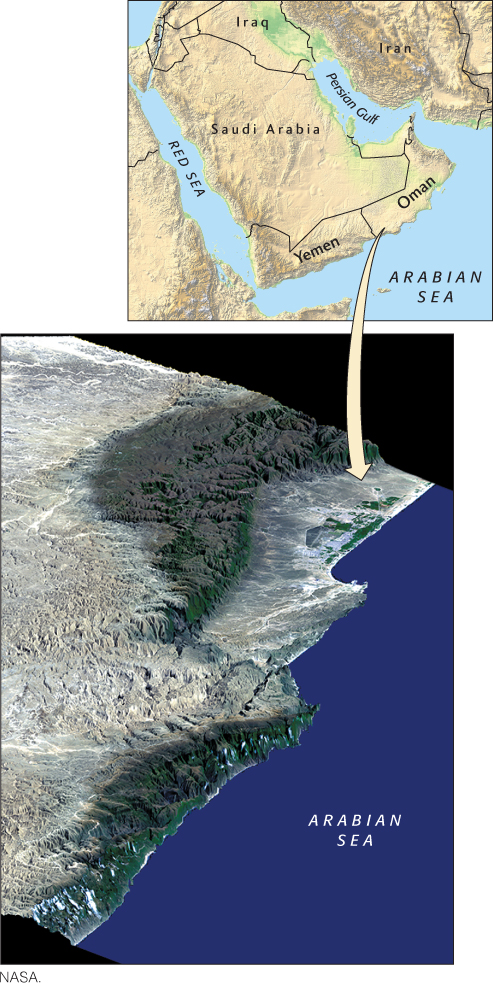
Just as climate affects topography, topography can affect climate. For example, dry areas called rain shadows may form on the leeward slopes of mountain ranges (see Figure 17.3). Rain shadows result in preferential erosion on the windward side of a mountain belt (Figure 22.17). Geologists believe that in places such as New Guinea, where the difference between rainfall on the windward and leeward sides of the mountain belt is extreme, the rate of exhumation of metamorphic rocks buried deep in the crust is influenced by the history of rainfall at Earth’s surface.
Feedback Between Uplift and Erosion
The ceaseless competition between plate tectonic processes, which tend to create mountains and build topography, and surface processes, which tend to tear them down, is the focus of intensive study by geomorphologists. Tectonic uplift provokes an increase in erosion (Figure 22.18a), so the higher mountains rise, the faster erosion wears them down. But as long as mountain building continues, their elevations stay high or increase. When mountain building slows, however—perhaps because of a change in the rate of plate movement—the mountains rise more slowly or stop rising entirely. As their growth slows or stops, erosion starts to dominate, and the mountains are worn down to lower elevations. This process explains why old mountains, such as the Appalachians, are relatively low compared with much younger mountains, such as the Rockies. As the mountains continue to be worn down, erosion also slows, and the whole process eventually tapers off. Elevation is thus a balance between the rate of tectonic uplift and the rate of erosion.

630
Curiously, over shorter time scales of thousands to millions of years, the plate tectonic and climate systems can interact such that mountains rise higher as a result of erosion (Figure 22.18b; see also Earth Issues 22.1). As we have seen, continents and mountains float on Earth’s mantle because they are less dense than the mantle material. Beneath a mountain range, where the crust is thickest, a deep root projects into the mantle and provides buoyancy. Although the mantle just beneath the crust is solid rock, it flows very slowly when forces are applied to it over thousands to millions of years (see Earth Issues 14.1). The principle of isostasy implies that, at these time scales, the mantle has little strength, and thus behaves like a viscous fluid when it is forced to support the weight of continents and mountains. The principle of isostasy also implies that as a mountain range forms, it slowly sinks under the force of gravity, and the continental crust bends downward. When enough of a root bulges into the mantle to provide buoyancy, the mountain range floats. When the valleys in a mountain range are deepened by erosion, however, the mass of the mountain range decreases, and less root is needed for buoyancy. Thus, as the valleys erode, the mountains float upward. This process, called isostatic rebound, results in mountain summits being elevated to new heights (see Figure 22.18b). Over longer time scales, however, erosion will inevitably wear those mountain summits down (see Figure 22.18a).