Models of Landscape Development
The strong contrasts of different landscapes stimulated early geologists to speculate about their causes. Three prominent and influential geologists who did so were William Morris Davis, Walther Penck, and John Hack. Davis believed that an initial burst of tectonic uplift is followed by a long period of erosion, during which landscape morphology depends mainly on geologic age. Davis’s view was so dominant during the early 1900s that it overshadowed that of his contemporary, Penck, who argued that tectonic uplift competes with erosion to control landscape morphology. In the 1960s, another conceptual breakthrough occurred when Hack recognized that uplift could not raise elevation above some critical limit, even if it were sustained for long periods. Rising mountains, in the absence of erosion, will collapse under their own weight.
631
Modern views of landscape development incorporate parts of these early ideas and acknowledge that there is a natural, time-dependent progression of landscape form. Geologists now understand that the developmental path of landscapes depends strongly on the time scale over which geomorphic change occurs. The importance of the different landscape-modifying processes depends on the interval of time over which the landscape is observed to change. For example, variations in climate have been important factors in landscape development over the past 100,000 years, but they are only a minor factor over time scales of 100 million years. Over these longer intervals of geologic time, the history of tectonic uplift is probably most important.
632
22.1 Uplift and Climate Change: A Chicken-and-Egg Dilemma
One of the clearest illustrations of how Earth’s climate and plate tectonic systems are coupled is provided by the feedbacks between climate and the elevation of mountain belts. Currently, there is controversy over the directionality of these feedbacks. Some geologists argue that tectonic uplift of mountainous regions leads to climate change, others that climate change may promote tectonic uplift. This type of debate is well characterized by the classic “chicken-and-egg dilemma”: which came first?
The debate is fueled by the observation that the cooling of the Northern Hemisphere’s climate and the uplift of the Himalaya and Tibetan Plateau may have been synchronous. The Tibetan Plateau is the most imposing topographic feature on the surface of Earth (see Figure 22.7). It is so high and so extensive in area that it may influence patterns of atmospheric circulation in the Northern Hemisphere. If the Tibetan Plateau did not exist, the climate of the Northern Hemisphere would probably be quite different.
Unfortunately, although the timing of the Northern Hemisphere cooling has been well calibrated by the ages of glacial deposits and by the isotopic record of temperature changes in deep-sea sediments, the timing of the uplift of the Tibetan Plateau is less certain. This is where the debate begins. If the uplift preceded the onset of the cooling, then it might be argued that tectonic uplift indirectly caused climate change. On the other hand, if the uplift lagged behind the onset of the cooling, then it might be argued that climate change promoted uplift as an isostatic response to enhanced erosion rates.
Point: Negative Feedback
The possibility that mountain building may have promoted cooling and glaciation in the Northern Hemisphere has been recognized for more than 100 years. Geologists who currently advocate this point of view believe that several important processes occurred in the uplift of the Tibetan Plateau that led to a negative feedback process. According to this scenario, uplift led to a change in atmospheric circulation, which led to cooling in the Northern Hemisphere, and that cooling resulted in an increase in precipitation, glaciation, and stream runoff in the Himalaya and on the plateau. These changes, in turn, produced higher rates of weathering, which led to removal of CO2—an important greenhouse gas—from the atmosphere. The reduced atmospheric CO2 concentrations led to further cooling, increased precipitation, and increased weathering and erosion. Over time, erosion will wear down the mountains, and their elevations will decrease. Effectively, an elevation increase—which then modulates climate—results in an elevation decrease—a negative feedback process.
Counterpoint: Positive Feedback
Over the past decade, geologists have discovered that climate change might lead to uplift in mountainous regions. According to this unexpected and counterintuitive scenario, an initial cooling would stimulate an increase in precipitation rates, which in turn would lead to enhanced erosion by glaciers and streams. In the absence of isostatic responses, an increase in erosion would act as a negative feedback to lower the mountain ranges. However, when we consider the influence of isostasy, we see that erosion could result in a decrease in the mass of the mountain range as a whole, so that the mountains would be uplifted and their peaks elevated to new and higher positions (see Figure 22.18b). The rising mountains would act as a positive feedback to modify climate further, thereby increasing precipitation and erosion rates and further enhancing uplift.
Davis’s Cycle: Uplift Is Followed by Erosion
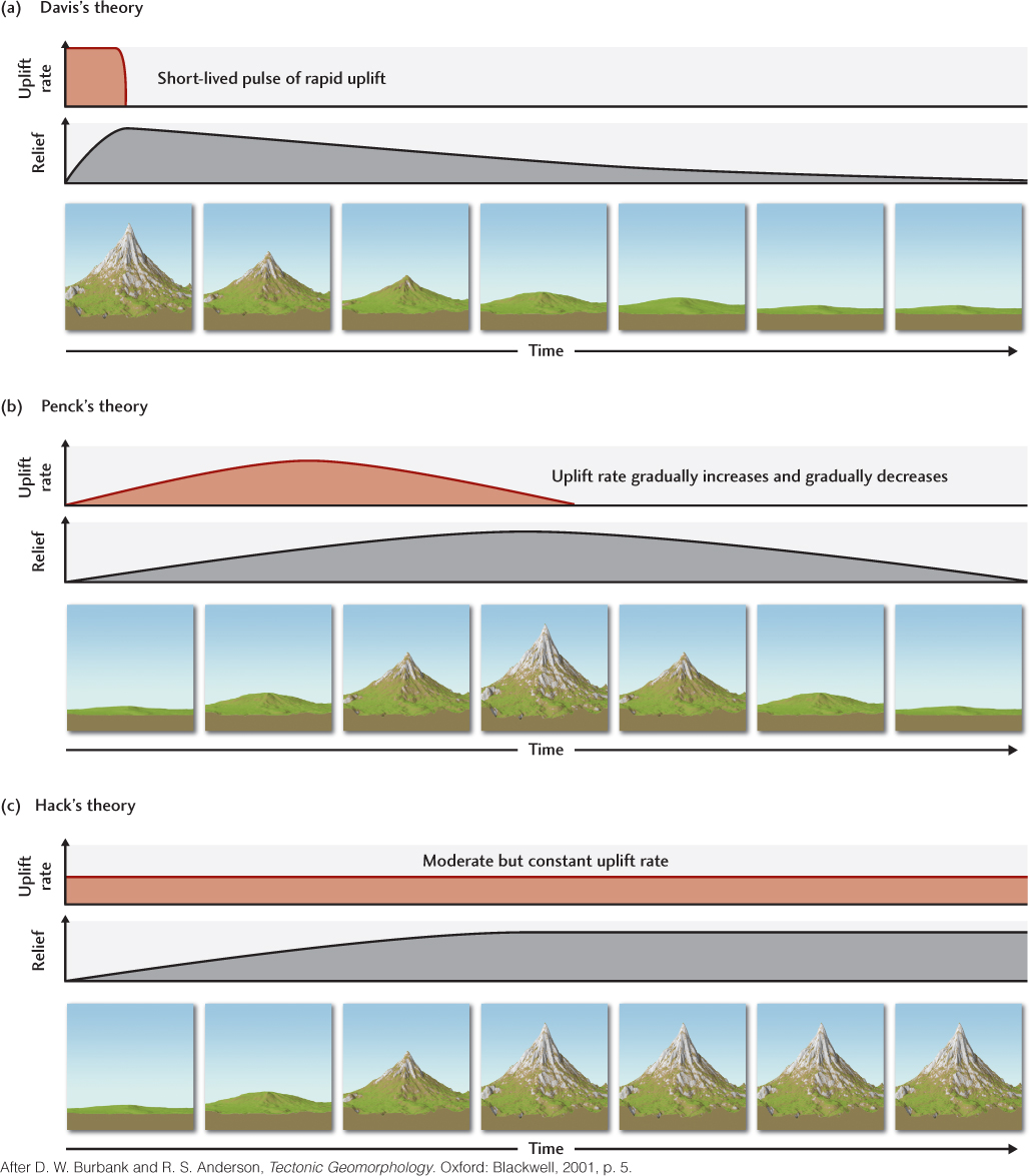
William Morris Davis, a Harvard geologist in the early 1900s, studied mountains and plains throughout the world. Davis proposed a cycle of erosion that progresses from the high, rugged, tectonically uplifted mountains of a young landscape to the rounded hills of maturity and the worn-down plains of old age and tectonic stability (Figure 22.19a). Davis believed that a strong, rapid pulse of tectonic uplift begins the cycle. All the topography is built during this first stage. Erosion eventually wears down the landscape to a relatively flat surface, leveling all structures and differences in bedrock. Davis observed the flat surfaces of extensive unconformities and saw them as evidence of such flat plains in past geologic times. Here and there, an isolated hill might stand as an uneroded remnant of former heights. Most geologists at that time accepted Davis’s assumption that mountains are elevated suddenly over short geologic time scales and then remain tectonically stable as erosion slowly wears them down. Davis’s cycle was accepted partly because geologists could find many examples of what seemed to be landscapes in his different stages of youth, maturity, and old age.
633
634
Penck’s Model: Erosion Competes with Uplift
Davis’s view was challenged by his contemporary, Walther Penck, who argued that the magnitude of tectonic deformation and uplift gradually increases to a climax and then slowly wanes (Figure 22.19b). Unfortunately, Davis, with his greater professional stature and prolific publication style, was able to promote his ideas more effectively. Penck’s ideas were not given the attention they deserved until the 1950s, more than two decades after Davis’s death.
Penck proposed that geomorphic surface processes attack the rising mountains throughout the interval of uplift. Eventually, as the rate of deformation wanes, erosion predominates over uplift, resulting in a gradual decrease in both relief and elevation. This model was a conceptual breakthrough because it recognized that landscape development may result from competition between uplift and erosion. Davis’s model, in contrast, emphasized the temporal distinction between these two processes. In his model, landscape age was the primary determinant of form.
635
Choosing between alternative theories of landscape development required that rates of uplift and erosion in regions of mountain building be determined. Technologies such as the Global Positioning System (GPS) and radar signals from other orbiting satellites have produced spectacular maps of crustal deformation and uplift rates. A number of dating methods (Table 22.1) have helped us determine the ages of geomorphically informative surfaces, such as stream valley terraces (see Figure 18.27) that date back 1 million years.
| Method | Useful Range (Years Ago) |
Materials Needed |
|---|---|---|
| RADIOISOTOPIC | ||
| Carbon-14 | 35,000 | Wood, shell |
| Uranium/thorium | 10,000–350,000 | Carbonate (corals) |
| Thermoluminescence (TL) | 30,000–300,000 | Quartz silt |
| Optically stimulated luminescence | 0–300,000 | Quartz silt |
| COSMOGENIC | ||
| In situ beryllium-10, aluminum-26 | 3–4 million | Quartz |
| Helium, neon | Unlimited | Olivine, quartz |
| Chlorine-36 | 0–4 million | Quartz |
| CHEMICAL | ||
| Tephrochronology | 0–several million | Volcanic ash |
| PALEOMAGNETIC | ||
| Identification of reversals | >700,000 | Fine sediments, volcanic lava flows |
| Secular variations | 0–700,000 | Fine sediments |
| BIOLOGICAL | ||
| Dendrochronology (tree rings) | 10,000 | Wood |
| Source: D. W. Burbank and R. S. Anderson, Tectonic Geomorphology. Oxford: Blackwell, 2001, p. 39. | ||
A promising new dating scheme is based on the fact that cosmic rays penetrating the uppermost meter of rock or soil exposed at Earth’s surface lead to the production of very small quantities of certain radioactive isotopes. One of them is beryllium-10, which accumulates to a greater degree the longer the rock or soil is exposed and to a lesser degree the deeper it is buried. Geologists used beryllium-10 to compare terrace ages along the course of the Indus River in the Himalaya. They then plotted height changes against time to find average erosion and uplift rates. Stream erosion rates in the Himalaya were found to vary between 2 and 12 mm/year (see Practicing Geology on pages 637–638). In other high mountain ranges, tectonic uplift rates have been measured in the same general range, from 0.8 to 12 mm/year.
636
Hack’s Model: Erosion and Uplift Achieve Equilibrium
John Hack elaborated on the idea that erosion competes with uplift. He believed that when uplift and erosion rates are sustained over long periods, landscape development will achieve a balance, or dynamic equilibrium (Figure 22.19c). During the period of equilibrium, landforms may undergo minor adjustments, but the overall landscape will look more or less the same.
Hack recognized that the height of mountains could not increase forever, even if uplift rates were extremely high. Rocks break if large enough stresses are imposed on them, so it stands to reason that if mountains become steeper than their angle of repose, they will collapse under their own weight. Thus, with continued uplift beyond some critical limit, slope failures and mass wasting alone will prevent further increases in elevation. Consequently, rates of uplift and rates of erosion come into a long-term balance. Unlike the models of Davis and Penck, Hack’s model does not require uplift rates to decrease.
A fascinating implication of Hack’s model is that geomorphology does not have to change at all as long as uplift and erosion rates are balanced. Nevertheless, Earth’s history teaches us that whatever goes up eventually does come down. Over very long time scales, the models of Davis and Penck are more accurate descriptions of how landscapes ultimately change in form. When erosion exceeds uplift, slopes become lower and more rounded (see Figure 22.18a). Because few areas of the world remain tectonically quiescent for as long as 100 million years, however, the perfectly flat plains that Davis proposed would have formed only rarely in Earth’s history. Hack’s model of dynamic equilibrium is perhaps most appropriate for landscapes in tectonically active areas where a given uplift rate can be sustained for more than a million years or so.
637