The Discovery of Plate Tectonics
In the 1960s, a great revolution in thinking shook the world of geology. For almost 200 years, geologists had been developing various theories of tectonics (from the Greek tekton, meaning “builder”)—the general term used to describe mountain building, volcanism, earthquakes, and other processes that construct geologic features on Earth’s surface. It was not until the discovery of plate tectonics, however, that a single theory could satisfactorily explain the whole range of geologic processes. Physics had a comparable revolution at the beginning of the twentieth century, when the theory of relativity revised the physical laws that govern space, time, mass, and motion. Biology had a similar revolution in the middle of the twentieth century, when the discovery of DNA allowed biologists to explain how organisms transmit the information that controls their growth and functioning from generation to generation.
The basic ideas of plate tectonics were put together as a unified theory of geology about 50 years ago. The scientific synthesis that led to the theory of plate tectonics, however, really began much earlier in the twentieth century with the recognition of evidence for continental drift.
Continental Drift
Such changes in the superficial parts of the globe seemed to me unlikely to happen if the earth were solid to the center. I therefore imagined that the internal parts might be a fluid more dense, and of greater specific gravity than any of the solids we are acquainted with, which therefore might swim in or upon that fluid. Thus the surface of the earth would be a shell, capable of being broken and disordered by the violent movements of the fluid on which it rested.
(Benjamin Franklin, 1782, in a letter to French geologist Abbé J. L. Giraud-Soulavie)
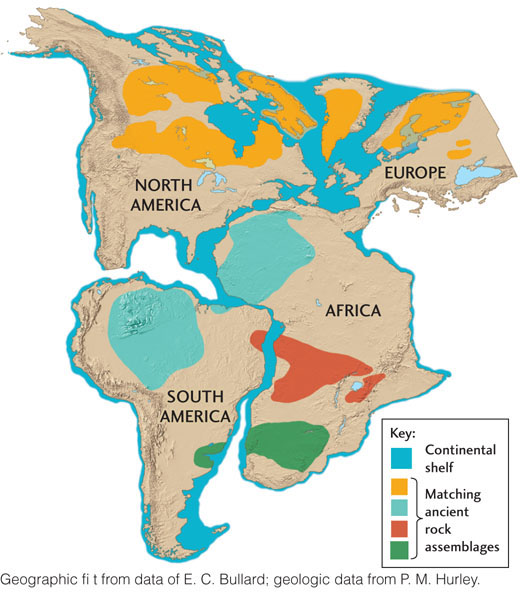
The concept of continental drift—large-scale movements of continents—has been around for a long time. In the late sixteenth century and in the seventeenth century, European scientists noticed the jigsaw-puzzle fit of the coasts on both sides of the Atlantic Ocean, as if the Americas, Europe, and Africa had once been part of a single continent and had subsequently drifted apart. By the close of the nineteenth century, the Austrian geologist Eduard Suess had put together some of the pieces of the puzzle. He postulated that the present-day southern continents had once formed a single giant continent called Gondwana (or Gondwanaland). In 1915, Alfred Wegener, a German meteorologist who was recovering from wounds suffered in World War I, wrote a book on the breakup and drift of continents, in which he laid out the remarkable similarity of geologic features on opposite sides of the Atlantic (Figure 2.1). In the years that followed, Wegener postulated a supercontinent, which he called Pangaea (Greek for “all lands”), that broke up into the continents as we know them today.
Although Wegener was correct in asserting that the continents had drifted apart, his hypotheses about how fast they were moving and what forces were pushing them across Earth’s surface turned out to be wrong, as we will see, and those errors reduced his credibility among other scientists. After about a decade of spirited debate, physicists convinced geologists that Earth’s outer layers were too rigid for continental drift to occur, and Wegener’s ideas were rejected by all but a few geologists.
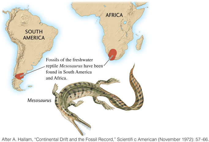
Wegener and other advocates of the drift hypothesis pointed not only to the geographic matching of geologic features but also to similarities in rock ages and trends in geologic structures on opposite sides of the Atlantic. They also offered arguments, accepted now as good evidence of drift, based on fossil and climate data. Identical 300-million-year-old fossils of the reptile Mesosaurus, for example, have been found in Africa and in South America, but nowhere else, suggesting that the two continents were joined when Mesosaurus lived (Figure 2.2). The animals and plants on the different continents showed similarities in their evolution until the postulated breakup time. After that, they followed different evolutionary paths because of their isolation and changing environments on the separating continents. In addition, rocks deposited by glaciers that existed 300 million years ago were found distributed across South America, Africa, India, and Australia. If these southern continents had once been part of Gondwana near the South Pole, a single continental glacier could account for all of these glacial deposits.
29
Seafloor Spreading
The geologic evidence did not convince the skeptics, who maintained that continental drift was physically impossible. No one had yet come up with a plausible driving force that could have split Pangaea and moved the continents apart. Wegener, for example, thought the continents floated like boats across the solid oceanic crust, dragged along by the tidal forces of the Sun and Moon. His hypothesis was quickly rejected, however, because it could be shown that tidal forces are much too weak to move continents.
The breakthrough came when scientists realized that convection in Earth’s mantle (described in Chapter 1) could push and pull continents apart, creating new oceanic crust through the process of seafloor spreading. In 1928, the British geologist Arthur Holmes proposed that convection currents “dragged the two halves of the original continent apart, with consequent mountain building in the front where the currents are descending, and the ocean floor development on the site of the gap, where the currents are ascending.” Many still argued, however, that Earth’s crust and mantle are rigid and immobile, and Holmes conceded that “purely speculative ideas of this kind, specially invented to match the requirements, can have no scientific value until they acquire support from independent evidence.”
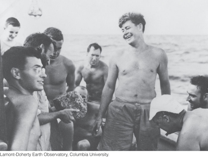
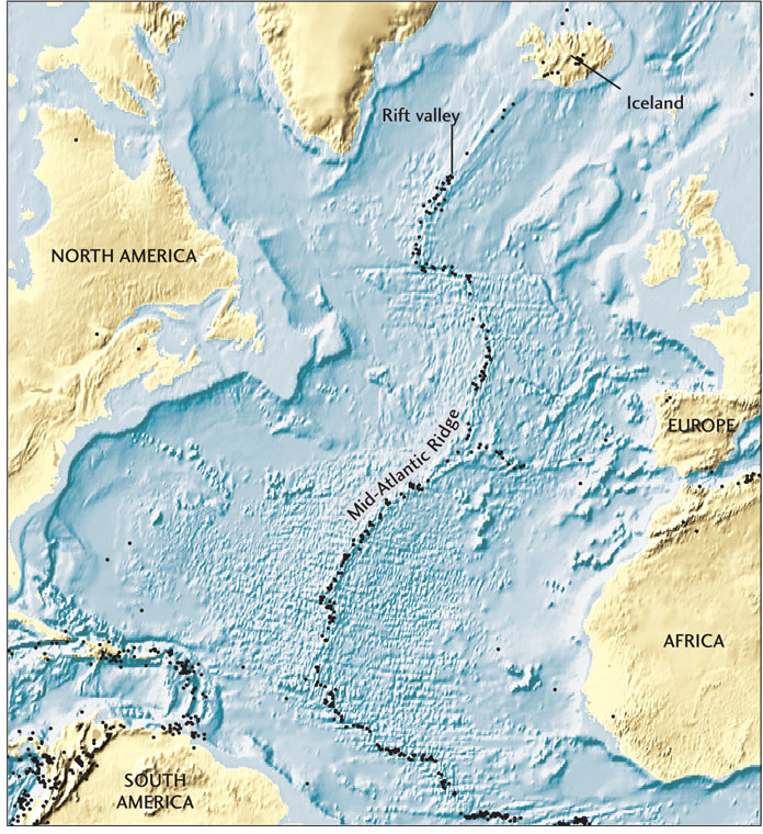
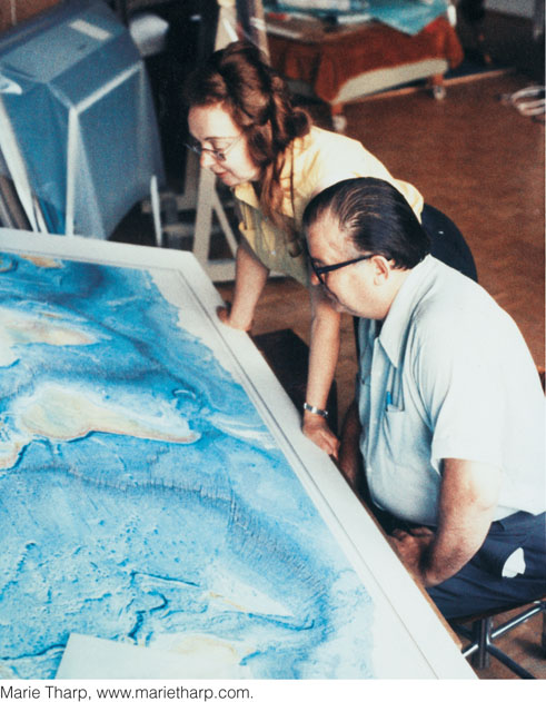
That evidence emerged from extensive explorations of the seafloor after World War II. Marine geologist Maurice “Doc” Ewing showed that the seafloor of the Atlantic Ocean is made of young basalt, not old granite, as some geologists had previously thought (Figure 2.3). Moreover, the mapping of an undersea mountain chain called the Mid-Atlantic Ridge led to the discovery of a deep cracklike valley, or rift, running down its crest (Figure 2.4). Two of the geologists who mapped this feature were Bruce Heezen and Marie Tharp, colleagues of Doc Ewing at Columbia University (Figure 2.5). “I thought it might be a rift valley,” Tharp said years later. Heezen initially dismissed the idea as “girl talk,” but they soon found that almost all earthquakes in the Atlantic Ocean occurred near the rift, confirming Tharp’s hunch. Because most earthquakes are generated by faulting, their results indicated that the rift was a tectonically active feature. Other mid-ocean ridges with similar rifts and earthquake activity were found in the Pacific and Indian oceans.
30
In the early 1960s, Harry Hess of Princeton University and Robert Dietz of the Scripps Institution of Oceanography proposed that Earth’s crust separates along the rifts in mid-ocean ridges, and that new crust is formed by the upwelling of hot molten rock into these cracks. The new seafloor—actually the surface of newly created lithosphere—spreads laterally away from the rifts and is replaced by even newer crust in a continuing process of plate creation.
The Great Synthesis: 1963–1968
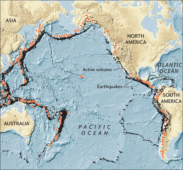
The seafloor spreading hypothesis put forward by Hess and Dietz explained how the continents could move apart through the creation of new lithosphere at mid-ocean ridges. But it raised another question: Could the seafloor and its underlying lithosphere be destroyed by recycling back into Earth’s interior? If not, Earth’s surface area would have to increase over time. For a while in the early 1960s, some physicists and geologists, including Heezen, actually believed in this idea of an expanding Earth. Other geologists recognized that the seafloor was indeed being recycled. They were convinced this was happening in several regions of intense volcanic and earthquake activity around the margins of the Pacific Ocean basin, known collectively as the Ring of Fire (Figure 2.6). The details of the process, however, remained unclear.
In 1965, the Canadian geologist J. Tuzo Wilson first described tectonics around the globe in terms of rigid plates moving over Earth’s surface. He characterized three basic types of boundaries where plates move apart, come together, or slide past each other. Soon after, other scientists showed that almost all contemporary tectonic deformation—the process by which rocks are folded, faulted, sheared, or compressed by tectonic forces—is concentrated at these boundaries. They measured the rates and directions of crustal movements and demonstrated that these movements are mathematically consistent with a system of rigid plates moving over the planet’s spherical surface.
31
The basic elements of the new theory of plate tectonics were established by the end of 1968. By 1970, the evidence for plate tectonics had become so persuasive that almost all Earth scientists embraced the theory. Textbooks were revised, and specialists began to consider the implications of the new concept for their own fields.