The Grand Reconstruction
The supercontinent Pangaea was the only major landmass that existed 250 million years ago. One of the great triumphs of modern geology was the reconstruction of the events that led to the assembly of Pangaea and to its later fragmentation into the continents we know today. Let’s use what we have learned about plate tectonics to see how this feat was accomplished.
43
Seafloor Isochrons
The color map in Figure 2.15 shows the ages of the rocks on the seafloor as determined from magnetic anomaly data and deep-sea drilling. Each colored band represents the span of time when the rocks within that band formed. Notice that the seafloor becomes progressively older on both sides of the mid-ocean ridges. The boundaries between bands are contours of equal seafloor age, or isochrons.
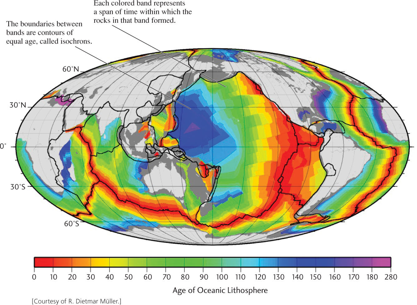
Isochrons tell us the time that has elapsed since the rocks were injected as magma into a spreading zone and, therefore, the amount of spreading that has occurred since they formed. For example, the distance from a ridge axis to a 100-million-year isochron (boundary between green and blue bands) indicates the extent of new seafloor created over that time span. The more widely spaced isochrons of the eastern Pacific signify faster spreading rates there than in the Atlantic.
In 1990, after a 20-year search, geologists found the oldest oceanic rocks by drilling into the seafloor of the western Pacific. These rocks turned out to be about 200 million years old, only 4 percent of Earth’s age. In contrast, the oldest known continental rocks are over 4 billion years in age. All existing seafloor is geologically young compared with the continents. Over a period of 100 million to 200 million years in some places, and only tens of millions of years in others, oceanic lithosphere forms by seafloor spreading, cools, and is recycled into the underlying mantle.
Reconstructing the History of Plate Movements
Earth’s plates behave as rigid bodies. That is, the distances between three points on the same rigid plate—say, New York, Miami, and Bermuda on the North American Plate—do not change very much, no matter how far the plate moves. But the distance between, say, New York and Lisbon increases over time because those two cities are on two different plates that are separating along the Mid-Atlantic Ridge. The direction of movement of one plate in relation to another depends on two geometric principles that govern the behavior of rigid plates on a sphere:
44
 Transform-fault boundaries indicate the directions of relative plate movement. With few exceptions, no overlap, buckling, or separation occurs along typical transform-fault boundaries in the oceans. The two plates merely slide past each other without creating or destroying plate material. Therefore, the orientation of the fault measures the direction in which one plate is sliding with respect to the other (see Figure 2.8f, g).
-
Seafloor isochrons reveal the positions of divergent boundaries in earlier times. Isochrons on the seafloor are roughly parallel and symmetrical to the ridge axis along which they were created (see Figure 2.15). Because each isochron was at the divergent boundary at an earlier time, isochrons that are of the same age but on opposite sides of a mid-ocean ridge can be brought together to show the positions of the plates, and the configuration of the continents embedded in them, as they were in that earlier time.
Using these principles, geologists have reconstructed the history of continental drift. They have shown, for example, how the skinny peninsula of Baja California was rifted away from the Mexican mainland during the last 5 million years (see Practicing Geology Exercise at the end of this chapter).
The Breakup of Pangaea
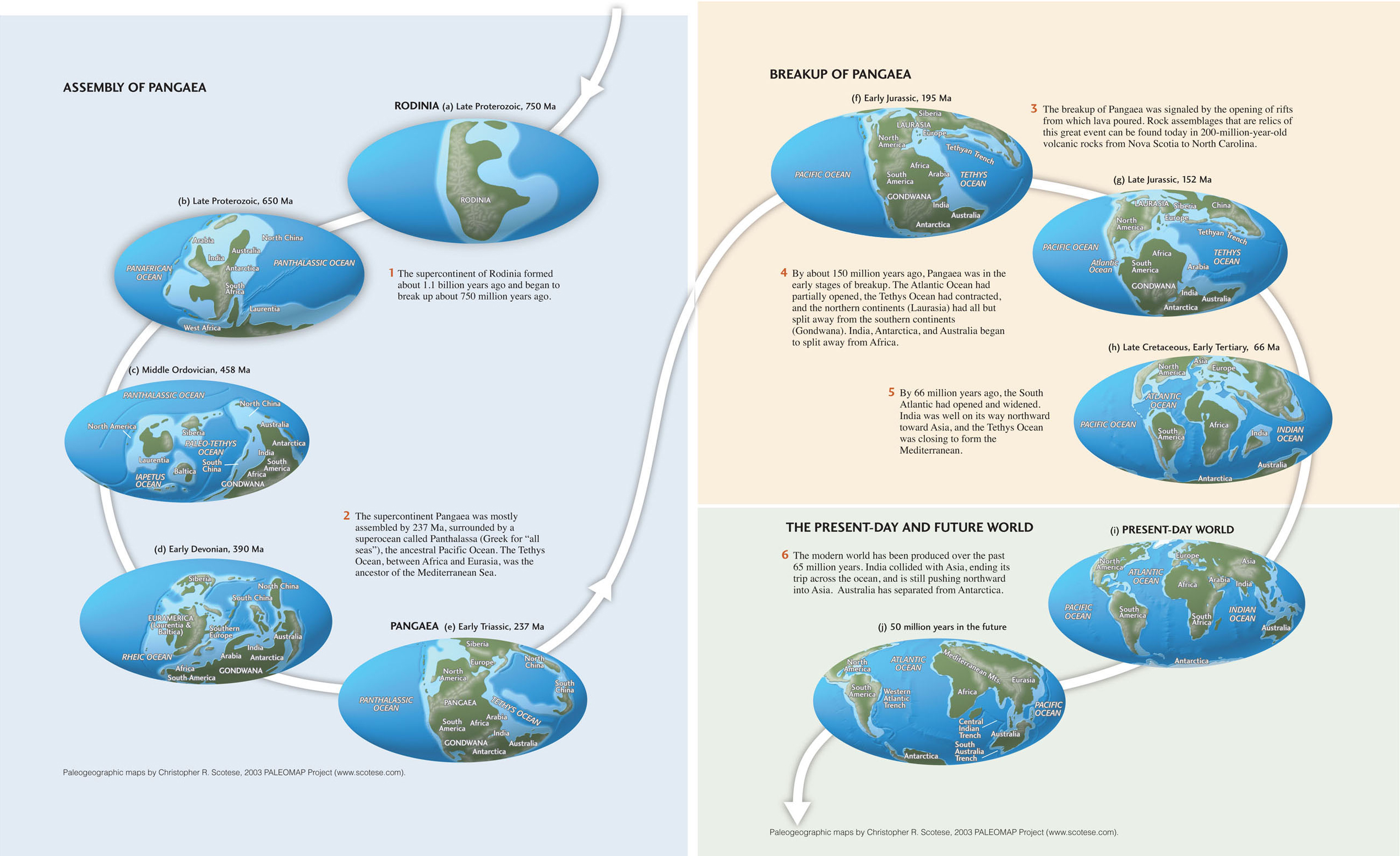
On a much grander scale, geologists have reconstructed the opening of the Atlantic Ocean and the breakup of Pangaea (Figure 2.16). Figure 2.16e shows the supercontinent Pangaea as it existed about 240 million years ago. It began to break apart when North America rifted away from Europe about 200 million years ago (Figure 2.16f). The opening of the North Atlantic was accompanied by the separation of the northern continents (referred to as Laurasia) from the southern continents (Gondwana) and the rifting of Gondwana along what is now the east coast of Africa (Figure 2.16g). The breakup of Gondwana separated South America, Africa, India, and Antarctica, creating the South Atlantic and Southern oceans and narrowing the Tethys Ocean (Figure 2.16h). The separation of Australia from Antarctica and the ramming of India into Eurasia closed the Tethys Ocean, giving us the world we see today (Figure 2.16i).
The plate movements have not ceased, of course, so the configuration of the continents will continue to evolve. A plausible scenario for the distribution of continents and plate boundaries 50 million years in the future is shown in Figure 2.16j.
The Assembly of Pangaea by Continental Drift
The isochron map in Figure 2.15 tells us that all of the seafloor on Earth’s surface today has been created since the breakup of Pangaea. We know from the geologic record in older continental mountain belts, however, that plate tectonics had been operating for billions of years before this breakup. Evidently, seafloor spreading took place just as it does today, and there were previous episodes of continental drift and collision. Subduction into the mantle has destroyed the seafloor created in those earlier times, however, so we must rely on the older evidence preserved on continents to identify and chart the movements of ancient continents (paleocontinents).
Old mountain belts, such as the Appalachians of North America and the Urals, which separate Europe from Asia, help us locate ancient collisions of the paleocontinents. In many places, the rocks reveal ancient episodes of rifting and subduction. Rock types and fossils also indicate the distribution of ancient seas, glaciers, lowlands, mountains, and climates. Knowledge of ancient climates enables geologists to locate the latitudes at which continental rocks formed, which in turn helps them to assemble the jigsaw puzzle of paleocontinents. When volcanism or mountain building produces new continental rocks, these rocks also record the direction of Earth’s magnetic field, just as oceanic crust does when it is created by seafloor spreading. Like a compass frozen in time, the thermoremanent magnetization of a continental fragment records its ancient orientation and magnetic latitude.
The left side of Figure 2.16 shows one of the latest efforts to depict the pre-Pangaean configuration of continents. It is truly impressive that modern science can recover the geography of this strange world of hundreds of millions of years ago. The evidence from rock types, fossils, and magnetization has allowed scientists to reconstruct an earlier supercontinent, called Rodinia, that formed about 1.1 billion years ago and began to break up about 750 million years ago (Figure 2.16a). They have been able to chart its fragments over the subsequent 500 million years as those fragments drifted and reassembled into the supercontinent Pangaea. Geologists continue to sort out the details of this complex jigsaw puzzle, whose individual pieces have changed shape over geologic time.
Implications of the Grand Reconstruction
Hardly any branch of geology remains untouched by this grand reconstruction of the continents. Economic geologists have used the former fit of the continents to find mineral and oil deposits by correlating the rock formations in which these resources exist on one continent with their predrift continuations on another continent. Paleontologists have rethought some aspects of evolution in light of continental drift. Geologists have broadened their focus from the geology of a particular region to a world-encompassing picture. The concept of plate tectonics provides a way to interpret, in global terms, such geologic processes as rock formation, mountain building, and climate change.
45
Past Climate Changes
Over millions of years, movements of the tectonic plates have rearranged the continents and oceans, affecting the climate system in profound ways. In the present arrangement, the waters of the Southern Ocean are able to circulate all the way around Antarctica, forming a “circumpolar seaway” that isolates the continent from the warmer water and air of tropical latitudes. This isolation keeps the southern polar regions colder than they might otherwise be, maintaining a massive ice sheet across the entire Antarctic continent.
The situation was rather different 66 million years ago, as shown in panel (h) of Figure 2.16. Australia was still connected to Antarctica, allowing currents of warmer water to flow southward and heat the polar continent. Also at this time, the North and South American continents were separated, so that water could flow between the Atlantic and Pacific oceans. The circumpolar seaway did not form until Australia broke away from Antarctica around 40 million years ago. Somewhat later, only about 5 million years ago, subduction in the eastern Pacific Ocean formed the isthmus of Panama, connecting North and South America and isolating the Atlantic from the Pacific.
These changes, combined with the collision of India with Asia, which formed the high plateau of Tibet (see Figure 2.16g), cooled the entire planet enough to create ice sheets of Antarctica in the southern hemisphere and Greenland in the northern hemisphere. The resulting modification of the climate system is thought to have initiated oscillations of climate between very cold periods (ice ages, described in Chapter 21) and somewhat warmer periods, such as the one we now enjoy.