Forms of Igneous Intrusions
As noted earlier, we cannot directly observe the shapes of igneous intrusions. We can deduce their shapes and distributions only by observing parts of them where they have been uplifted and exposed by erosion, millions of years after the magma that formed them intruded and cooled.
We do have indirect evidence of current magmatic activity. Seismic waves, for example, have shown us the general outlines of the magma chambers that underlie some active volcanoes. In some nonvolcanic but tectonically active regions, such as an area near the Salton Sea in Southern California, measurements in deep drill holes reveal crustal temperatures much hotter than normal, which may be evidence of a magmatic intrusion nearby. But these methods cannot reveal the detailed shapes or sizes of intrusions.
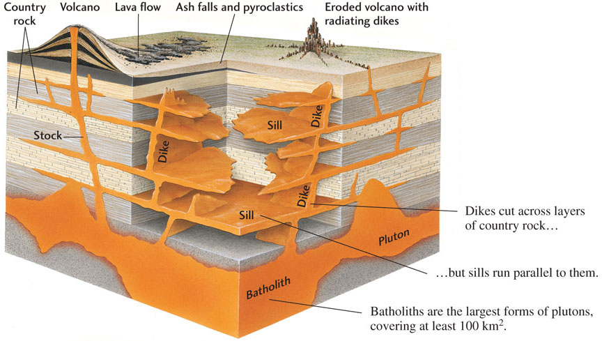
Most of what we know about igneous intrusions is based on the work of field geologists who have examined and compared a wide variety of outcrops and have reconstructed their histories. In the following pages, we consider some of these forms. Figure 4.9 illustrates a variety of intrusive and extrusive structures.
103
Plutons
Plutons are large igneous bodies formed deep in Earth’s crust. They range in size from a cubic kilometer to hundreds of cubic kilometers. We can study these large bodies when uplift and erosion uncover them or when mines or drill holes cut into them. Plutons are highly variable, not only in size but also in shape and in their relationship to the country rock.
This wide variation is due in part to the different ways in which magma makes space for itself as it rises through the crust. Most plutons intrude at depths greater than 8 to 10 km. At these depths, there are few holes or openings in the country rock because the pressure of the overlying rock would close them. But the upwelling magma overcomes even that great pressure.
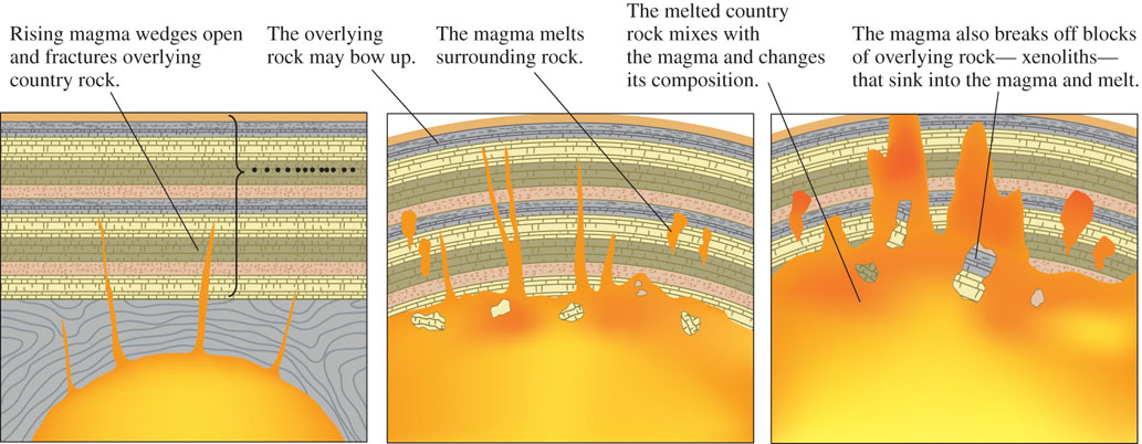
Magma rising through the crust makes space for itself in three ways (Figure 4.10) that may be referred to collectively as magmatic stoping:
- 1. Wedging open the overlying rock. As the rising magma lifts the great weight of the overlying rock, it fractures that rock, penetrates the cracks, wedges them open, and so flows into the rock. Overlying rocks may bow upward during this process.
- 2. Melting surrounding rock. Magma also makes its way by melting country rock.
- 3. Breaking off large blocks of rock. Magma can push its way upward by breaking off blocks of the invaded crust. These blocks, known as xenoliths (from the Greek for “foreign rocks”), sink into the magma, where they may melt and blend into the liquid, in some places changing the composition of the magma.
Most plutons show sharp zones of contact with country rock and other evidence of the intrusion of liquid magma into solid rock. Some plutons grade into country rock and contain structures vaguely resembling those of sedimentary rocks. The features of these plutons suggest that they formed by partial or complete melting of preexisting sedimentary rock.
Batholiths, the largest plutons, are great irregular masses of coarse-grained igneous rock that, by definition, cover at least 100 km2 (see Figure 4.10). They are thick, horizontal, sheetlike or lobe-shaped bodies extending from a funnel-shaped central region. Their bottoms may extend 10 to 15 km deep, and a few are estimated to go even deeper. The coarse grain of batholiths results from slow cooling at great depths. Other, smaller plutons are called stocks. Both batholiths and stocks are discordant intrusions; that is, they cut across the layers of the country rock that they intrude.
Sills and Dikes
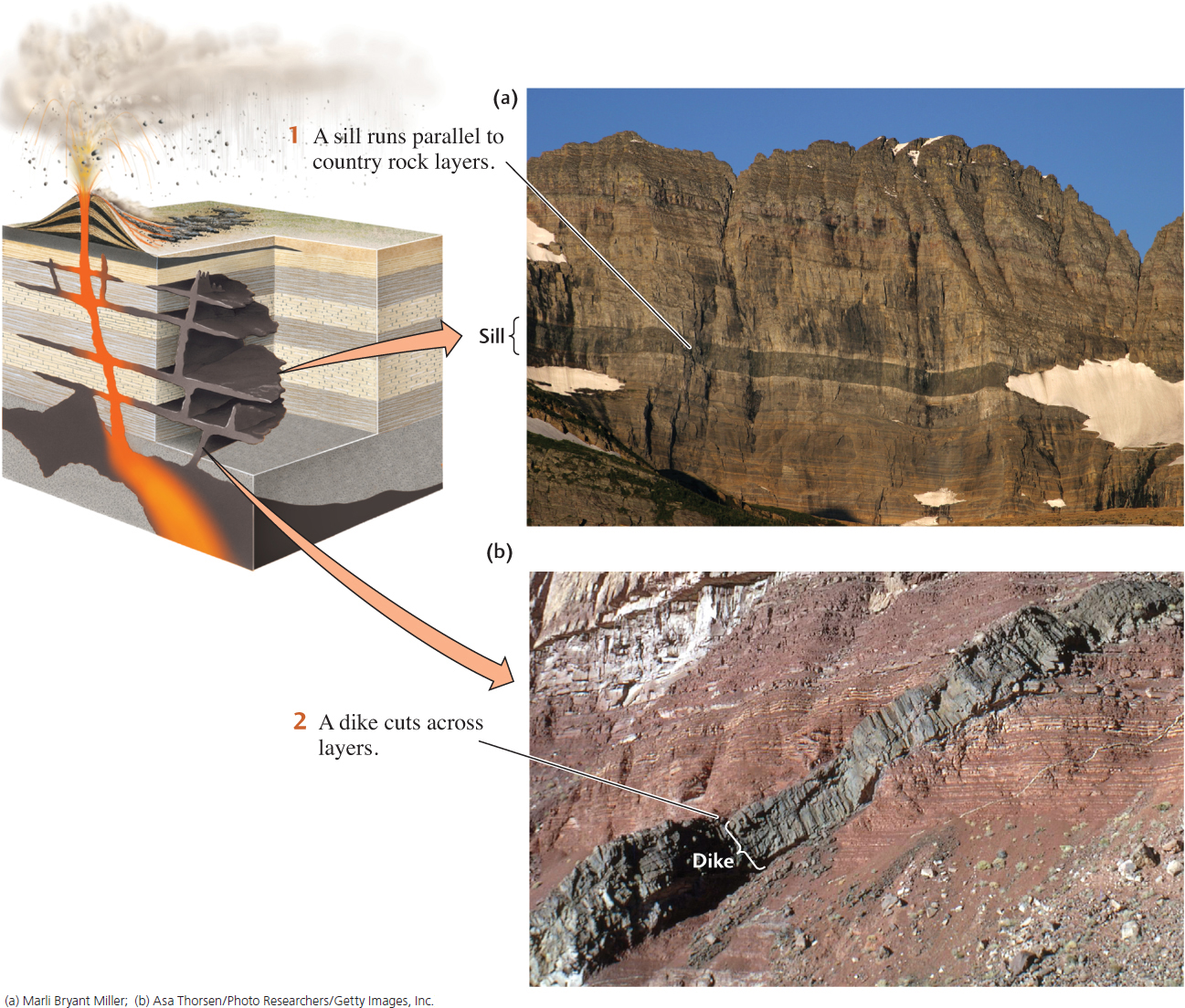
Sills and dikes are similar to plutons in many ways, but they are smaller and have a different relationship to the layering of the country rock (Figure 4.11). A sill is a sheetlike body formed by the injection of magma between parallel layers of bedded country rock. Sills are concordant intrusions; that is, their boundaries lie parallel to the country rock layers, whether or not those layers are horizontal. Sills range in thickness from a single centimeter to hundreds of meters, and they can extend over considerable areas. Figure 4.11a shows a large sill at Finger Mountain, Antarctica. The 300-m-thick Palisades intrusion (see Figure 4.7) is another large sill.
104
Sills may superficially resemble lava flows and pyroclastic deposits, but they differ from those layers in four ways:
- 1. They lack the ropy, blocky, and vesicle-filled structures that characterize many volcanic rocks (see Chapter 12).
- 2. They are more coarse-grained than volcanic rocks because they have cooled more slowly.
- 3. Rocks above and below sills show the effects of heating: their color may have been changed or their mineral composition altered by contact metamorphism.
- 4. Many lava flows overlie weathered older flows or soils formed between successive flows; sills do not.
Dikes are the major route of magma transport in the crust. Dikes, like sills, are sheetlike igneous bodies, but dikes cut across the layers in bedded country rock (Figure 4.11b) and so are discordant intrusions. Dikes sometimes form by forcing open existing fractures in the country rock, but more often they create channels through new cracks opened by the pressure of rising magma. Some individual dikes can be followed in the field for tens of kilometers. Their thicknesses vary from many meters to a few centimeters. In some dikes, xenoliths provide evidence of disruption of the country rock during the intrusion process. Dikes rarely exist alone; more typically, swarms of hundreds or thousands of dikes are found in a region that has been deformed by a large igneous intrusion.
The textures of dikes and sills vary. Many are coarse-grained, with an appearance typical of intrusive rocks. Many others are fine-grained and look much more like volcanic rocks. Because we know that texture corresponds to the rate of cooling, we can conclude that the fine-grained dikes and sills invaded country rock nearer Earth’s surface, where the country rock was cold compared with the intrusions. Their fine texture is the result of rapid cooling. The coarse-grained ones formed at depths of many kilometers and invaded warmer rocks whose temperatures were much closer to their own.
105
Veins
Veins are deposits of minerals found within a rock fracture that are foreign to the country rock. Irregular pencil-shaped or sheet-shaped veins branch off from the tops and sides of many igneous intrusions. They may be a few millimeters to several meters across, and they tend to be tens of meters to kilometers long or wide. The formation of veins is described in more detail in Chapter 3.
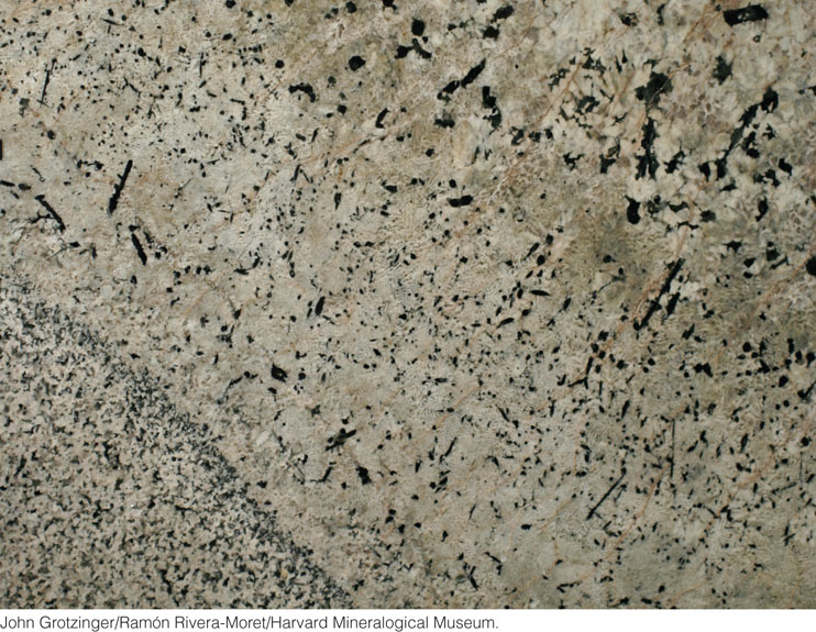
Veins of extremely coarse grained granite cutting across much finer grained country rock are called pegmatites (Figure 4.12). Pegmatites crystallize from a water-rich magma in the late stages of solidification.
Other veins are filled with hydrous minerals that are known to crystallize from hydrothermal solutions. From laboratory experiments, we know that these minerals typically crystallize at temperatures of 250°C to 350°C—high temperatures, but not nearly as high as the temperatures of magmas. The solubility and composition of the minerals in these hydrothermal veins indicate that abundant water was present as the veins formed. Some of the water may have come from the magma itself, but some may have been underground water in the cracks and pore spaces of the intruded rocks. On land, groundwaters originate as rainwater seeps into the soil and surface rocks. Hydrothermal veins are also abundant along mid-ocean ridges, where seawater infiltrates cracks in the newly formed seafloor, circulates down into hotter regions of the ridge, and reemerges at hydrothermal vents in the rift valley between the spreading plates. Hydrothermal processes at mid-ocean ridges are examined in more detail in Chapter 12.