Styles of Continental Deformation
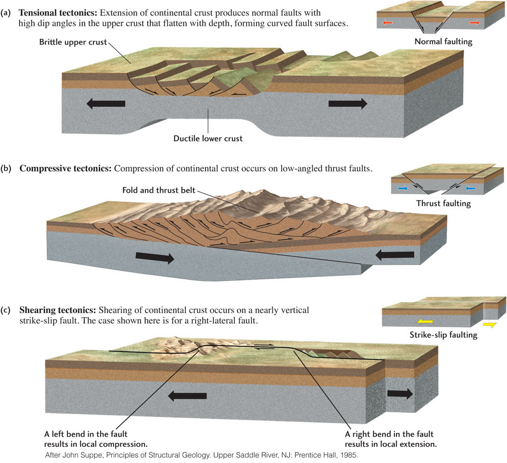
If we look closely enough, we can find all the basic deformation structures—faults, folds, domes, basins, joints—in any zone of continental deformation. But when we view continental deformation at a regional scale, we see distinctive patterns of faulting and folding that relate directly to the tectonic forces causing the deformation. Figure 7.19 depicts the deformation styles typical of the three main types of tectonic forces.
Tensional Tectonics
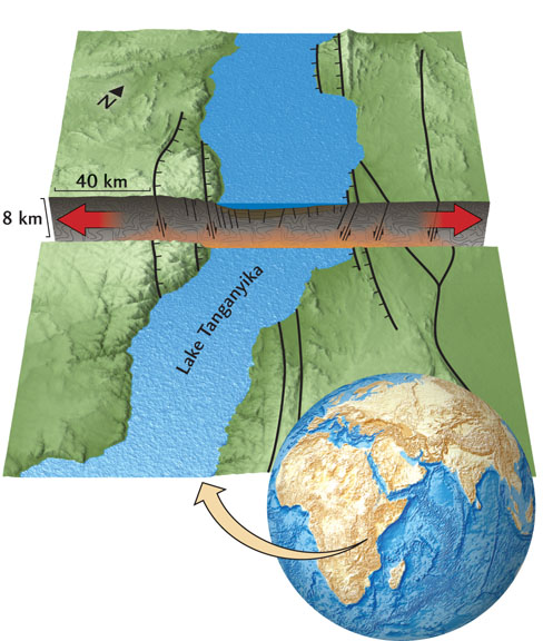
In brittle crust, the tensional forces that produce normal faulting may split a plate apart, resulting in a rift valley—a long, narrow trough formed when a block of rock drops downward relative to its two flanking blocks along nearly parallel, steeply dipping normal faults (Figure 7.19a). Well-known examples include the Rhine Valley, the rift valleys of East Africa (Figure 7.20), and the Red Sea, as well as the rift valleys of mid-ocean ridges. As we saw in Chapter 5, these structures form basins that fill with sediments eroded from the rift walls as well as with volcanic rocks extruded from tensional cracks in the crust.
Tension on the shallow continental crust usually produces normal faults with high dip angles, typically 60° or more. Below a depth of about 20 km, however, crustal rocks are hot enough to behave as ductile materials, and deformation occurs by stretching rather than by fracturing. This change in rock behavior causes the dip of the faults to flatten with increasing depth, which results in normal faults with curved fault surfaces (called listric faults), as shown in Figure 7.19a. The crustal blocks moving along these curved faults are tilted backward as the stretching continues.
185
The Basin and Range province, which is centered on the Great Basin of Nevada and Utah, is a good example of a region defined by many adjacent rift valleys. This region, which is now more than 800 km wide, has been stretched and extended in a northwest-southeast direction by a factor of 2 during the last 15 million years. Here, normal faulting has created an immense landscape of eroded, rugged fault-block mountains and smooth, sediment-filled valleys, some covered with recent volcanic rocks (see Figure 10.5). This tensional deformation, which appears to be caused by upwelling convection currents beneath the Basin and Range province, continues today.
Compressive Tectonics
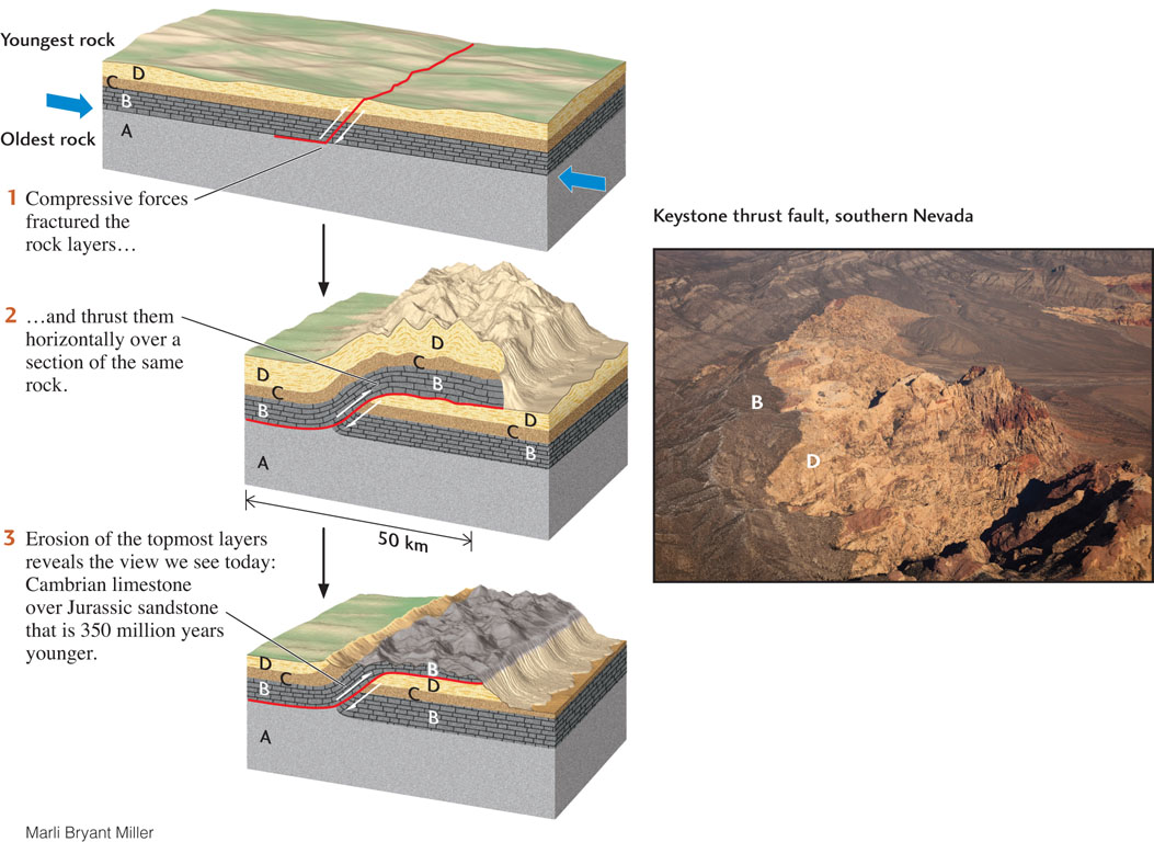
In subduction zones, oceanic lithosphere slips beneath an overriding plate along a huge thrust fault, or megathrust. The world’s largest earthquakes, such as the great Tohoku, Japan, earthquake of March 11, 2011, which generated a disastrous tsunami that killed more than 19,000 people, are caused by sudden slips on megathrusts. Thrust faulting is also the most common type of faulting within continents undergoing tectonic compression. Sheets of crust may glide over one another for tens of kilometers along nearly horizontal thrust faults, forming overthrust structures (Figure 7.21).
186
When two continents collide, the crust can be compressed across a wide zone, resulting in spectacular episodes of mountain building. During such collisions, the brittle basement rocks ride over one another by thrust faulting while the more ductile overlying sedimentary rocks are compressed into a series of great folds, forming a fold and thrust belt (Figure 7.19b). Large earthquakes are common in fold and thrust belts; a recent example is the great Wenchuan earthquake that hit Sichuan, China, on May 12, 2008, killing more than 80,000 people.
The ongoing collisions of Africa, Arabia, and India with the southern margin of the Eurasian continent have created fold and thrust belts from the Alps to the Himalaya, many of which are still active. The great oil reservoirs of the Middle East are trapped in anticlines formed by this deformation. Compression across western North America, caused by that continent’s westward movement during the opening of the Atlantic Ocean, created the fold and thrust belt of the Canadian Rockies. The Valley and Ridge province of the Appalachian Mountains is an ancient fold and thrust belt that dates back to the collisions that created the supercontinent Pangaea.
187
Shearing Tectonics
A transform fault is a strike-slip fault that forms a plate boundary. Transform faults such as the San Andreas can offset geologic formations by long distances (see Figure 7.7), but as long as they stay aligned with the direction of relative plate movement, the blocks on either side can slide past each other without much internal deformation. Long transform faults are rarely straight, however, so deformation patterns along these faults can be much more complicated. The faults may have bends and jogs that change the tectonic forces acting across portions of the plate boundary from shearing forces to compressive or tensional forces. Those forces, in turn, cause secondary faulting and folding (Figure 7.19c).
A good example of these complications can be found in Southern California, where the right-lateral San Andreas fault bends first to the left and then to the right as one moves along its trace from south to north (Figure 7.22). The segments of the fault on both sides of this “Big Bend” are aligned with the direction of relative plate movement, so the blocks slip past each other there by simple strike-slip faulting. Within the Big Bend, however, the change in the fault orientation causes the plates to push against each other, which produces thrust faulting to the south of the fault. This thrusting has raised the San Gabriel and San Bernardino mountains to elevations exceeding 3000 m and, during the last half century, has produced a series of destructive earthquakes, including the 1994 Northridge quake, which caused more than $40 billion in damage to Los Angeles (see Chapter 13).
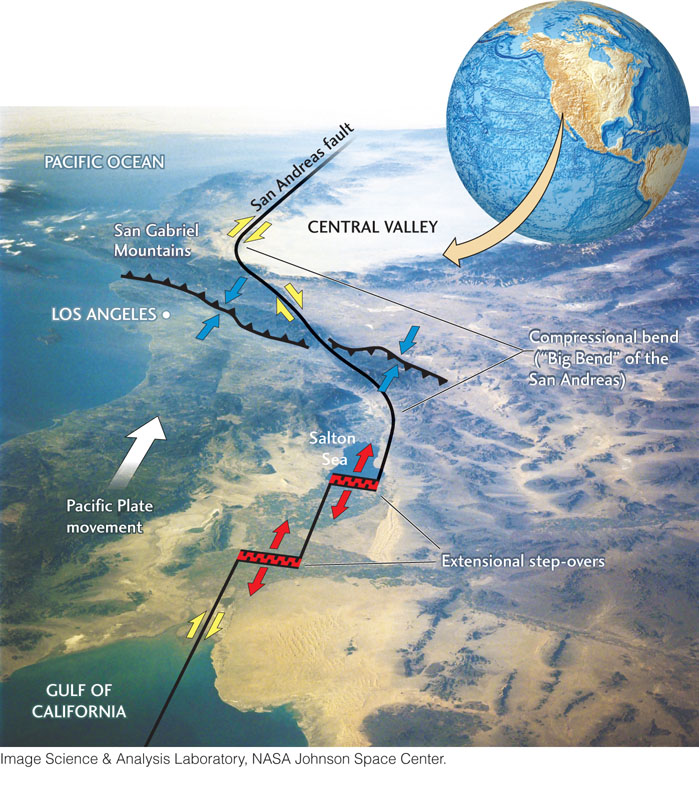
At the southern end of the San Andreas, between the Gulf of California and the Salton Sea, the boundary between the Pacific and North American plates jogs to the right in a series of steps. Within these jogs, the plate boundary is subjected to tensional forces, and normal faulting has formed small rift valleys that are volcanically active, rapidly subsiding, and filling with sediments. This extension occurs within 200 km of the Big Bend compression, demonstrating how variable the tectonics along continental transform faults can be!
188