The Geologic Time Scale: Relative Ages
Early in the nineteenth century, geologists began to apply Steno’s and Smith’s stratigraphic principles to outcrops all over the world. The same distinctive fossils were discovered in similar formations on many continents. Moreover, faunal successions from different continents often displayed the same changes in fossil assemblages. By matching up faunal successions and using cross-cutting relationships, geologists could determine the relative ages of rock formations on a global basis. By the end of the century, they had pieced together a worldwide history of geologic events—a geologic time scale.
Intervals of Geologic Time
The geologic time scale divides Earth’s history into intervals marked by distinct sets of fossils, and it places the boundaries of those intervals at times when those sets of fossils changed abruptly (Figure 8.11). The basic divisions of this time scale are the eras: the Paleozoic (from the Greek paleo, meaning “old,” and zoi, meaning “life”), the Mesozoic (“middle life”), and the Cenozoic (“new life”).
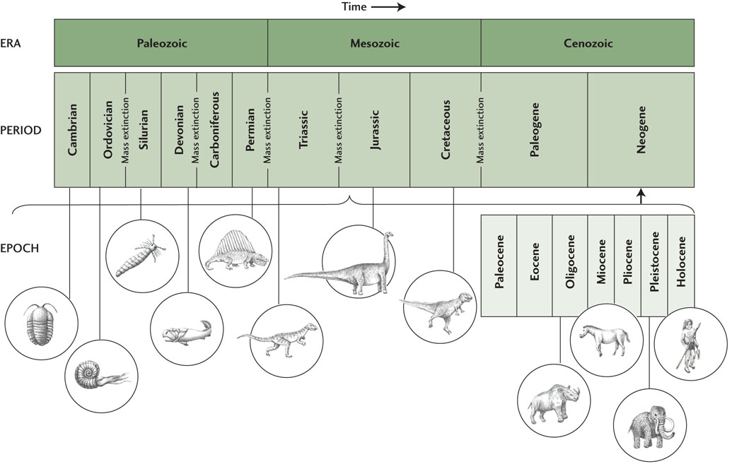
The eras are subdivided into periods, usually named for the locality in which the formations representing them were first or best described, or for some distinguishing characteristic of the formations. The Jurassic period, for example, is named for the Jura mountain range of France and Switzerland, and the Carboniferous period is named for the coal-bearing sedimentary rocks of Europe and North America. The Paleogene and Neogene periods of the Cenozoic are two exceptions: these Greek names mean “old origin” and “new origin,” respectively.
Some periods are further subdivided into epochs, such as the Miocene, Pliocene, and Pleistocene epochs of the Neogene period (see Figure 8.11). Today we are living in the Holocene (“completely new”) epoch of the Neogene period in the Cenozoic era.
Interval Boundaries Mark Mass Extinctions
Many of the major boundaries in the geologic time scale represent mass extinctions: short intervals during which a large proportion of the species living at the time simply disappeared from the fossil record, followed by the blossoming of many new species. These abrupt changes in faunal successions were a great mystery to the geologists who discovered them. Darwin’s theory of evolution explained how new species could evolve, but what had caused the mass extinctions?
203
204
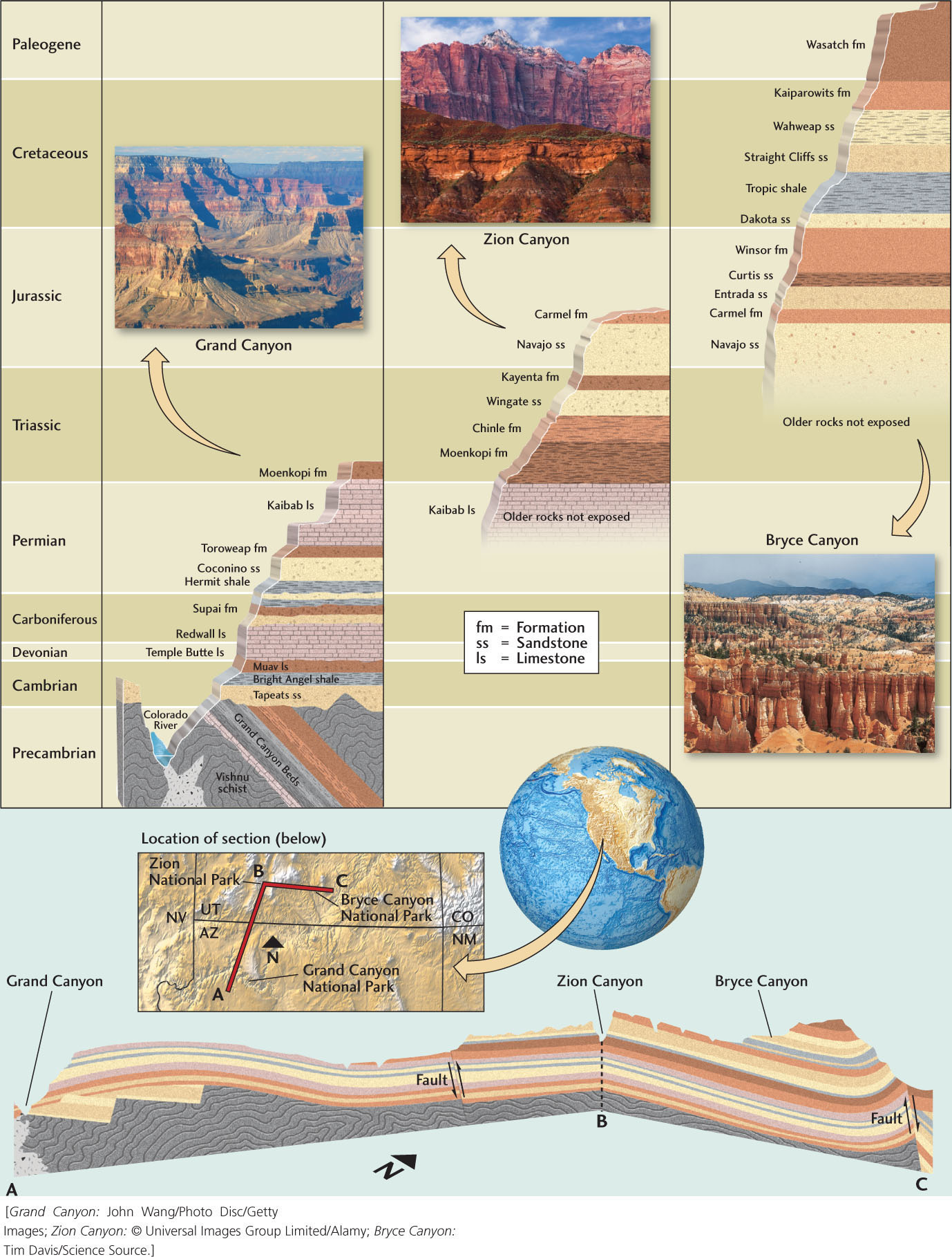
8.1 Stratigraphy of the Colorado Plateau: An Exercise in Relative Dating
We can use the strata exposed in the Grand Canyon and other parts of the Colorado Plateau to illustrate how relative dating works. These beds record a long history of sedimentation in a variety of environments, sometimes on land and sometimes under water. By matching the rock formations exposed at different localities, geologists have constructed a stratigraphic succession over a billion years long that spans both the Paleozoic and Mesozoic eras.
The lowest—and therefore oldest—rocks exposed in the Grand Canyon are dark igneous and metamorphic rocks that make up the Vishnu schist, a group of formations that have been shown to be about 1.8 billion years old.
Above the Vishnu schist are the younger Grand Canyon Beds. Although these sedimentary rocks contain fossils of single-celled microorganisms that provide evidence of early life, they do not contain the shelly fossils distinctive of the Cambrian and later periods, so they are categorized as Precambrian rocks.
A nonconformity separates the Vishnu schist and the Grand Canyon Beds. This structure indicates a period of deformation accompanying metamorphism of the Vishnu schist, and then a period of erosion, before the deposition of the Grand Canyon Beds. The tilting of the Grand Canyon Beds from their originally horizontal position shows that they, too, were folded after deposition and burial.
An angular unconformity divides the Grand Canyon Beds from the overlying horizontal Tapeats sandstone (see Figure 8.7). This unconformity indicates a long period of erosion after the lower rocks had been tilted. The Tapeats sandstone and Bright Angel shale can be dated as Cambrian by their fossils, many of which are trilobites.
Above the Bright Angel shale is a group of horizontal limestone and shale formations (Muav limestone, Temple Butte limestone, Redwall limestone) that represent a roughly 200-million-year history of marine sedimentation from the late Cambrian to the Carboniferous. There are so many time gaps represented by disconformities in these rocks that less than 40 percent of the Paleozoic is actually represented by rock strata (see Exercise 4).
The next set of strata, high up on the canyon wall, is the Supai formation (Carboniferous and Permian), which contains fossils of land plants like those found in the coal beds of North America and other continents. Overlying the Supai formation is the Hermit shale, a sandy red shale.
Continuing up the canyon wall, we find another continental deposit, the Coconino sandstone. This formation contains vertebrate animal tracks, which suggests that the Coconino was formed in a terrestrial environment during the Permian period. At the top of the cliffs at the canyon rim are two more formations of Permian age: the Toroweap, made mostly of limestone, is overlain by the Kaibab, a massive layer of sandy and cherty limestone. These two formations record subsidence below sea level and the deposition of marine sediments.
Above the Kaibab limestone and the canyon rim itself, but exposed within Grand Canyon National Park, is the Moenkopi formation, a red sandstone of Triassic age—the first appearance of rocks from the Mesozoic era in this stratigraphic succession.
The stratigraphic succession at the Grand Canyon, though picturesque and informative, represents an incomplete picture of Earth’s history. Younger intervals of geologic time are not preserved there, and we must travel to nearby locations in Utah, such as Zion Canyon and Bryce Canyon, to fill in this more recent history. At Zion Canyon, we find equivalents of the Kaibab limestone and Moenkopi formation, which allow us to correlate this stratigraphic succession with the one at the Grand Canyon and establish a link. Unlike the Grand Canyon strata, however, the Zion strata extend upward to Jurassic time, including ancient sand dunes represented by the Navajo sandstone. In Bryce Canyon, to the east of Zion, we again find the Navajo sandstone, as well as strata that extend still farther upward, to the Wasatch formation of the Paleogene period.
The correlation of strata among these three areas of the Colorado Plateau shows how widely separated localities—each with an incomplete record of geologic time—can be pieced together to build a composite record of Earth’s history.
205
206
In some cases, we think we know. The mass extinction at the end of the Cretaceous period, which killed off 75 percent of the living species, including all the dinosaurs, was almost certainly the result of a large meteorite impact that darkened and poisoned the atmosphere and plunged Earth’s climate into many years of bitter cold. This disaster marks the end of the Mesozoic era and the beginning of the Cenozoic. In other cases, we are still not sure. The largest mass extinction, at the end of the Permian period, which defines the Paleozoic-Mesozoic boundary, eliminated nearly 95 percent of all living species, but the cause of this event is still debated. The extreme events that separate intervals of geologic time are the subject of very active research, as we will see in Chapter 11.
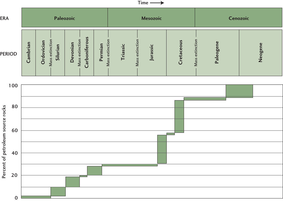
Ages of Petroleum Source Rocks
Oil and natural gas come from organic matter that was buried in sedimentary rock formations at some time in the geologic past. The relative ages of these “petroleum source rocks” provide important clues about where to look for new oil and gas resources. Global surveys have shown that very little petroleum has come from Precambrian rocks, which makes sense, because the primitive organisms that existed before the Cambrian period generated little organic matter.
Petroleum source rocks were deposited during all three of the geologic eras following the Cambrian, although certain periods of geologic time have produced much more of this resource than others (Figure 8.12). The clear winners are the Jurassic and Cretaceous periods of the Mesozoic era, which together have accounted for almost 60% of the world’s petroleum production. Sedimentary formations of Jurassic and Cretaceous age were the source rocks for the great oil fields of the Middle East, the Gulf of Mexico, Venezuela, and the North Slope of Alaska.
207
If you examine Figure 2.16, you can see that, during these periods of geologic time, the supercontinent of Pangaea was breaking up into the modern continents. This tectonic activity formed many marine sedimentary basins and increased the rate at which sediments were deposited into these basins. During the Jurassic and Cretaceous periods, which comprise the Age of Dinosaurs, marine life was abundant, providing much of the organic matter that was buried in the sediments. This carbon-rich material has since been “cooked” and transported into the oil reservoirs, where we find it today.