Mars Rocks!
We live in the golden age of Mars exploration. At the time of this writing, there are two robotic rovers operating on the surface of the planet, and three orbiters are circling it. These five spacecraft are returning a seemingly endless stream of new data that are leading to significant new discoveries. Our understanding of the history of past surface environments on Mars is changing dramatically. And the fun won’t end soon: both NASA and the European Space Agency have promised to deliver an additional rover in the next few years, and plans are being made to return rock samples from Mars to Earth. All the scientists involved in these missions are grateful to live in a time of such adventure.
Our understanding of surface processes on Mars was dramatically improved when two golf-cart-sized robots landed on Mars in January 2004. The Mars Exploration Rovers, named Spirit and Opportunity, began their 300-million-kilometer journey from Cape Canaveral, Florida, to the Red Planet in June 2003, accompanied by the Mars Express, an orbiter equipped with geologic remote sensing tools. These missions succeeded beyond anyone’s expectations, making 2004 and 2005 two of the greatest years in the history of space exploration. Another new orbiter, Mars Reconnaissance Orbiter, which started its mission in 2006, has collected a vast set of observations that show evidence of aqueous processes over broad regions of the planet. Its camera is taking stunning pictures of the surface of Mars at unprecedented resolution (25 cm/pixel). The Phoenix lander conducted operations in the polar region of Mars from June to November 2008 and confirmed the presence of water ice just a few centimeters below the dusty surface. In August 2012, the Mars Science Laboratory Curiosity rover made its spectacular landing in Gale crater on Mars (a video of the “Seven Minutes of Terror” can be found at: http://www.jpl.nasa.gov/video/index.php?id=1090). At the time of writing, it is currently in its two-year primary mission, driving toward the 5-kilometer-high Mt. Sharp in the center of the crater that contains a rich record of the early environmental history of Mars when the planet may have been habitable. (One of the authors of this textbook, John Grotzinger, is the Chief Scientist for the Curiosity rover team.)
238
Missions to Mars: Flybys, Orbiters, Landers, and Rovers
Earlier missions to Mars helped lay the groundwork for the success of the current missions. All spacecraft sent to Mars since the early 1960s have worked in one of four ways. First, the pioneering Mars exploration spacecraft, such as Mariner 4, flew by Mars while quickly acquiring all the data they could before disappearing into deep space.
The second, and most common, mode of operation is to orbit Mars in the same way satellites orbit Earth. Mariner 9, launched in May 1971, was the first spacecraft to orbit another planet. Since that time, eight other orbiters have helped map the surface of Mars. Mars Odyssey, Mars Express, and Mars Reconnaissance Orbiter are still active today. After a very successful mission spanning over 10 years, Mars Global Surveyor ceased operations in 2006.
The third method of observing Mars involves landing a spacecraft on the Martian surface. The Viking mission deployed two spacecraft, each of which consisted of an orbiter and a lander. The Viking 1 lander touched down on the surface of Mars on July 20, 1976, and became the first spacecraft to land on another planet and transmit useful data back to Earth. The Viking mission gave us our first look at the surface of another planet from the ground. It also provided our first chemical analyses of Martian rocks and performed the first life-detection experiments.
The fourth method of exploring Mars involves the use of a rover: a robotic vehicle that can move about on the surface of the planet. As exciting as the Viking mission was, it was two decades until another spacecraft landed safely on the surface of Mars. This time it was Pathfinder, which arrived on July 4, 1997. However, the Pathfinder lander also included a shoebox-sized rover—called Sojourner—that was able to ramble around on the surface, analyzing rocks and soils, within a few meters of the Pathfinder lander. Sojourner was the first mobile vehicle to operate successfully on another planet and became the prototype for the much larger and more capable Mars Exploration Rovers that landed in 2004.
Early Missions: Mariner (1965–1971) and Viking (1976–1980)
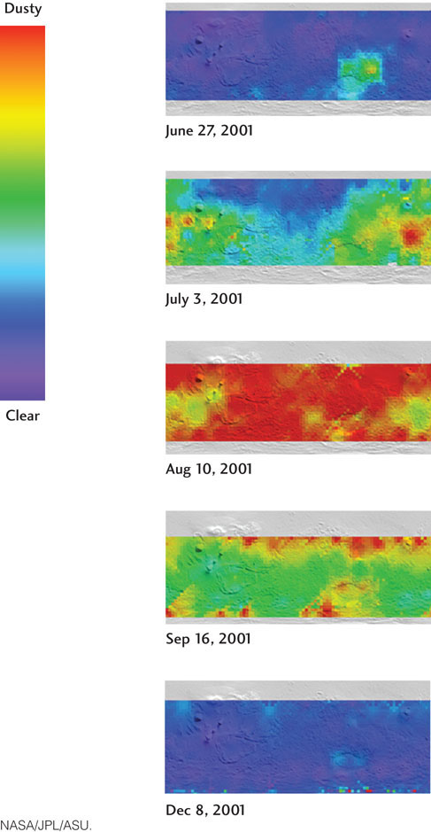
The Mariner and Viking missions returned the first detailed images of Mars to Earth. We saw a cratered Moon-like terrain over part of its surface. In other areas, we saw spectacular features, including enormous volcanoes and canyons, vast dune fields, ice caps at both poles, and the Martian moons Phobos and Deimos. Early images also confirmed global dust storms that had previously been observed from Earth. Orbiting spacecraft continue to monitor these dust storms (Figure 9.19).
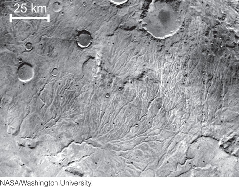
In addition, extensive networks of stream channels were discovered, providing the first evidence that liquids—possibly water—may once have flowed across the surface of Mars (Figure 9.20). Collectively, these data also revealed something that had not been appreciated before: the planet is divisible into two main regions, northern low plains and southern cratered highlands.
239
The two Viking landers provided high-resolution views of the Martian terrain. Both landing sites were strewn with rocks, somewhat rounded by the effects of windblown sand. Chemical sensors showed that the rocks and soils were predominantly basaltic in composition. But all the rocks were loose, and there was no evidence of any exposed bedrock. An onboard biology experiment found no evidence of life at either site. These missions revealed that the Red Planet is red because of the presence of iron oxides in the soils, and that the color of the Martian sky is not blue, but pink, because of the high concentration of suspended iron oxide dust particles.
Pathfinder (1997)
Pathfinder’s camera returned images very similar to those from the Viking landers: the landing sites were rocky, with windblown sand forming tails behind some rocks, and there was no evidence of any exposed bedrock. However, in addition to evidence of basalts, the Sojourner rover detected evidence of andesites. The presence of andesites on Mars indicates that at least some parts of the Martian crust were formed by partial melting of previously formed basalts, suggesting a more complex history of crustal development than previously believed.
The Pathfinder instrument suite also included a magnet that collected dust from the atmosphere for analysis. The dust was found to contain magnetic minerals that form only in environments low in oxygen.
Mars Global Surveyor (1996–2006) and Mars Odyssey (2001–)
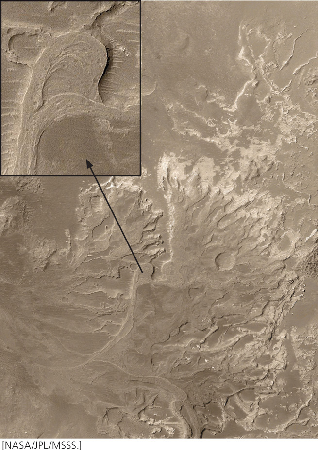
The vastly improved global mapping capabilities of Mars Global Surveyor and Mars Odyssey resulted in a number of significant discoveries. Mars Global Surveyor carried a laser-based altimeter that surveyed Martian topography with unprecedented resolution. The new images provided the strongest evidence yet for liquid water, this time expressed as meandering stream deposits of loose sediment (Figure 9.21). The channels carved into bedrock observed by the Viking orbiters suggested flowing water; however, the presence of meandering stream deposits (see Chapter 18) is even stronger evidence for flowing water on the surface of Mars. But it was not until 2004 that the Mars Exploration Rovers first confirmed the presence of minerals that require liquid water to have been present.
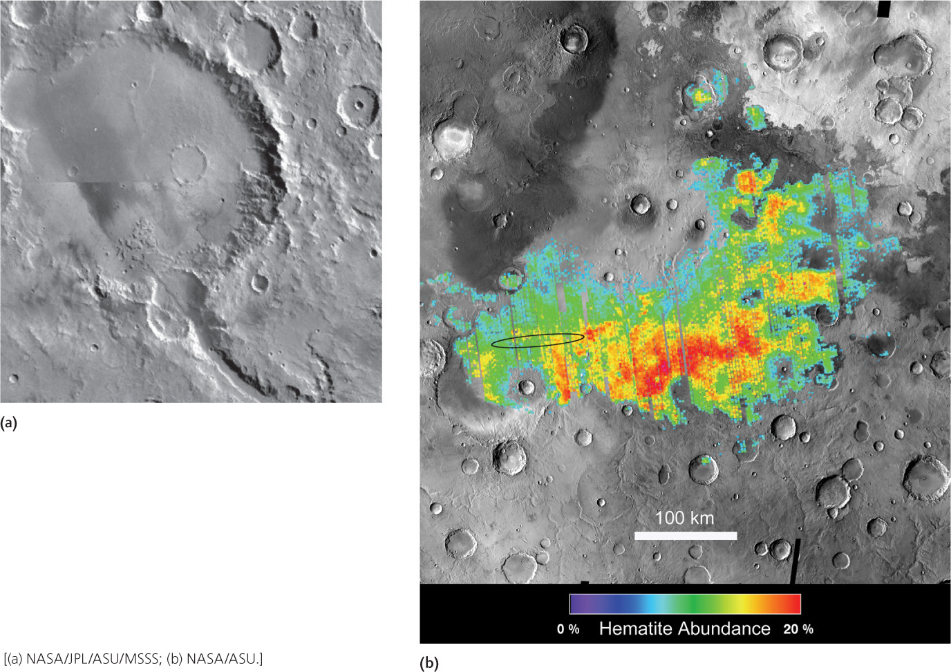
Mars Global Surveyor and Mars Odyssey also showed that permafrost (soil rich in water ice; see Chapter 21) underlies the Martian soil from the mid-latitudes all the way to the poles. Widespread glaciers were also shown to have been present in the relatively recent past, suggesting that Mars—like Earth—may have experienced ice ages driven by changes in global climate. Finally, Mars Global Surveyor discovered rare patches of hematite (Fe2O3)—a mineral that often forms in water on Earth—scattered over the surface of Mars. As we will see, this discovery contributed to the success of the Mars Exploration Rovers mission.
240
Mars Exploration Rovers: Spirit and Opportunity
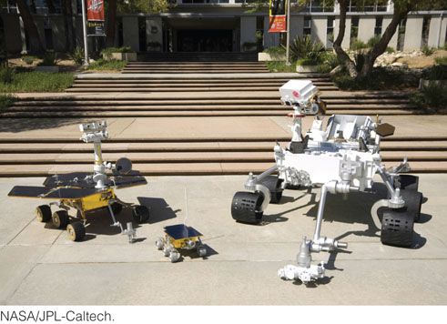
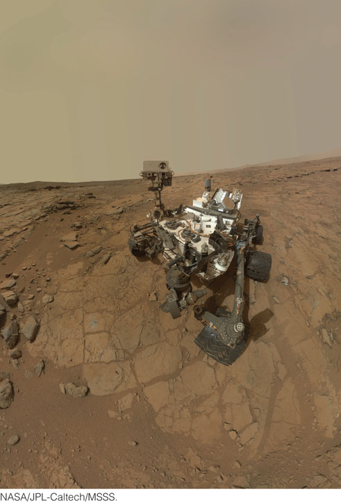
The Mars Exploration Rovers—Spirit and Opportunity (Figure 9.22)—were the first spacecraft sent to Mars that function almost as well as a human geologist would. Unlike orbiters, which look from afar, and landers, which cannot move from their landing site, Spirit and Opportunity can move around from rock to rock, picking and choosing which rocks to study in more detail. And when the right rock is found, the rover can look at it with a hand lens—just as geologists do here on Earth in the classroom and in the field. But unlike geologists on Earth, these rovers carry a mobile laboratory, so that the rocks can be analyzed on the spot without having to pay the enormous costs of flying them back to Earth. Because of this remarkable capability, Spirit and Opportunity have been dubbed the first robotic geologists on Mars.
The Mars Exploration Rovers were designed to survive 3 months under the hostile Martian surface conditions and to drive no farther than 300 m. They have since traveled more than 40 km in total across the Martian surface and Opportunity is still operating at the time of this writing in 2013 (Spirit stopped working in 2010). They have had to survive nighttime temperatures below −90°C, dust devils that could have tipped them over, global dust storms that diminished their solar power, and drives along rocky slopes of almost 308 and through piles of treacherous windblown dust. Despite all these obstacles, the rovers have discovered a treasure trove of geologic wonders.
Mars Science Laboratory (MSL): Curiosity
Curiosity launched in 2011 and landed in Gale crater on Mars in August 2012. The overall scientific goals of the mission are to assess whether the field site where the rover landed ever had environmental conditions favorable to microbial life. Curiosity is similar to Spirit and Opportunity, but is about twice as long (3 meters or 10 feet) and five times as heavy—it literally weighs a ton (Figure 9.23). It also has the most sophisticated suite of instruments ever sent to another planet. While the MER rovers are solar powered, Curiosity is powered by a radioisotope power system, which gets its energy from the natural decay of plutonium.
Gale crater has a 5-kilometer-high mountain in its center—Mt. Sharp—which is made up of sedimentary strata with a diverse suite of hydrated minerals, which indicate that these strata at least in part formed the presence of water. Curiosity has spent much of the first year of its primary mission in an area called Yellowknife Bay, where it has already found evidence of a potentially habitable environment, preserved in rocks over 3 billion years old. Streams once flowed from the crater rim toward the base of Mt. Sharp where water pooled to form a lake that had low salinity and neutral pH—both favorable for life. Curiosity is currently on its way to investigate materials at the base of Mt. Sharp where it will continue the search for additional habitable environments that may have characterized this part of Mars over 3 billion years ago.
241
What’s Under The Hood?
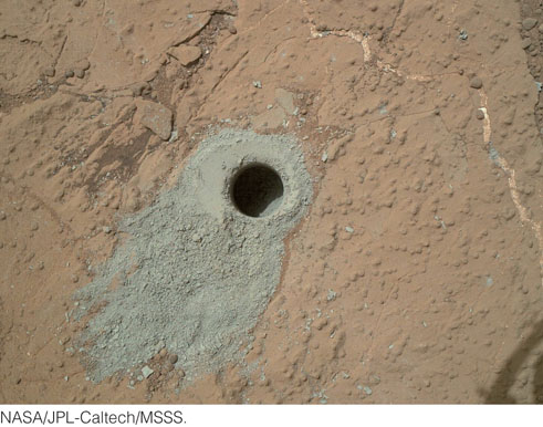
Spirit and Opportunity both come equipped with six-wheel drive, a color stereo camera with human vision, front-and-back hazard avoidance cameras, a magnifying “hand lens” for close-up inspection of rocks and soils, and instruments to detect the chemical and mineral composition of rocks and soils. A sample of Curiosity’s instruments include HD-resolution color cameras with video capability, detectors that measure radiation that might be harmful to humans, and a weather station (wind direction and velocity, atmospheric pressure, humidity, etc.). At its core, Curiosity carries two laboratory instruments that provide information on the mineral composition of drilled samples (Figure 9.24), as well as their elemental and isotopic composition, and the presence of any organic compounds. The MER rovers are powered by solar energy, while MSL is powered by a nuclear power source, and all are controlled by scientists on Earth, who send daily command sequences to each rover via radio signals. Because it takes 10 minutes for these signals to travel between Earth and Mars, the rovers have some self-controlled navigation and hazard avoidance capabilities. However, almost every other decision is made by a team of humans back on Earth. This arrangement ensures that the rovers “think” as geologists do. Onboard computers receive the command sequences from Earth that control each rover activity, including driving; taking pictures of the terrain, rocks, and soils; analyzing rocks and minerals; and studying the atmosphere and moons of Mars.
Rover Landing Sites
The Mars Exploration Rovers mission was motivated by the search for evidence of liquid water on Mars. The rovers were built with this goal in mind and sent to two locations where data from Mars Global Surveyor and Mars Odyssey suggested that the chances of finding geologic evidence for water would be high. (Some of the best places, however, were eliminated from consideration because of the extreme risk of landing in a rocky terrain; see the Practicing Geology Exercise at the end of the chapter.) Two of several hundred possible sites were chosen, both near the Martian equator but on opposite sides of the planet. The equatorial positions provide the rovers’ solar panels with maximum energy throughout the year. By the time that Curiosity landed 10 years later, engineers at the Jet Propulsion Laboratory in Pasadena, CA, had learned how to develop a landing system that could deliver the rover to a very specific site with very high science value. Four final sites were selected by the science team, and all four were accessible by the landing system. The finalist—Gale crater—was chosen because it had the greatest diversity of science targets. This turned out to be critically important and the first target explored—Yellowknife Bay—was successful in achieving the mission goal of a habitable ancient environment. Though Curiosity is extremely capable, the landing system was also critically important in helping to enable this discovery.
Spirit was sent to Gusev Crater, a large crater about 160 km in diameter that is thought to have once filled up with water to form a large lake (Figure 9.25a). Opportunity was sent to Meridiani Planum (“Plains of Meridiani”), where hematite had been detected by Mars Global Surveyor (Figure 9.25b). Since landing, Spirit trekked across a volcanic plain, ascended the Columbia Hills, and crawled down the other side to arrive at an outcrop whose distinctive shape won it the name of Home Plate. After this long and difficult trek, one of Spirit’s left front wheels locked up. But, by turning around and driving backward so it could drag rather than push the broken wheel, Spirit finally made it to a part of Home Plate where it made an important discovery: mineral deposits made up of more than 90 percent silica. These deposits indicate that heated waters that once flowed at or near the surface of Mars carried high concentrations of dissolved silica, which precipitated to form hard crusts, similar to what occurs in the hot springs at Yellowstone National Park on Earth today—a place where microorganisms are known to thrive (see the chapter opening photo in Chapter 11). Thus, Spirit’s discovery of high-silica rocks suggests the potential for a once-habitable environment that could be confirmed by a future mission with a set of instruments similar to Curiosity’s.
242
Opportunity landed in Eagle Crater (a small crater about 20 m in diameter), where it spent 60 days studying the first sedimentary rocks ever found on another planet and gathering evidence that they must have formed in water. Opportunity then moved on to another, larger crater (Endurance Crater, about 180 m in diameter), where it spent the next 6 months putting those sedimentary rocks into a broader context of environmental evolution. Opportunity then traveled 5 km to a much larger crater (Victoria Crater, about 1 km in diameter), where it has explored even more expansive outcrops of sedimentary rock. Opportunity discovered an ancient sandy desert where shallow pools of water once filled depressions between the sand dunes. These pools of water are thought to have been very acidic and also extremely saline. Microorganisms can survive in extremely acidic waters, as we will see in Chapter 11; however, if salinity becomes too high, the availability of water to the microorganisms becomes limited, and they cannot survive. (In a similar way, but substituting sugar for salt, that is why honey does not spoil, even without refrigeration or addition of preservatives.) Thus, Opportunity has also discovered evidence of a potentially habitable environment, albeit one that would have required microorganisms to live in extreme conditions. Opportunity then drove over 10 kilometers to arrive at Endeavor crater where it discovered very ancient basaltic rocks that were altered to form clay-bearing deposits that indicate more neutral pH. This more ancient setting would have been more favorable for microorganisms had they ever originated on Mars.
Curiosity landed at the foot of Mt. Sharp—Gale’s central mountain—near the end of an ancient alluvial fan that formed by sediments transported by streams from the crater rim. After landing it then drove 600 meters to the east where it discovered fine-grained sedimentary rocks that preserve evidence of a past aqueous environment characterized by low salinity and neutral pH. At the time of this writing Curiosity is in the midst of a 10-km-long drive to the lower reaches of the mountain, where sedimentary rocks can be found that contain clay, sulfate, and iron-bearing minerals that likely formed in the presence of water. Gale is special because it contains a wide diversity of ancient aqueous environments. By exploring this diversity of geologic materials scientists hope to discover which kinds of rocks are favorable for preserving evidence of ancient habitable environments, as well as organic compounds that could be returned to Earth by future missions and analyzed for evidence of life.
243
Recent Missions: Mars Reconnaissance Orbiter (2006–) and Phoenix (May–November 2008)
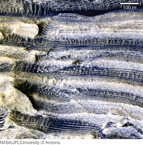
Mars Reconnaissance Orbiter has been mapping the rocks and minerals of Mars at an unprecedented level of detail. Whereas the rovers are limited to a few kilometers of the Martian surface, the orbiter can map anywhere on the planet. It is equipped with several instruments, including a high-resolution stereo color camera capable of resolving objects on the surface of Mars as small as 1 m across. Another important device looks at the sunlight reflected from the Martian surface to reveal the presence of minerals that formed in water. One of the orbiter’s most remarkable observations is the discovery of sedimentary layers that are so evenly bedded that they may preserve a record of periodic changes in the Martian climate that occurred billions of years ago (Figure 9.26).
In May 2008, a new lander touched down on the surface of Mars. It was named Phoenix because it was the twin of another lander (Mars Polar Lander) that crashed on the surface of Mars in 1999. NASA scientists studied the causes of the malfunction and became confident that they could get it right with the remaining twin. The name Phoenix seemed appropriate for a project that was resurrected from the ashes of a former ruin. In Egyptian and Greek mythology, the phoenix is a bird that can periodically burn and regenerate itself.
Phoenix was sent to search for ice in the polar region of Mars. Equipped with solar panels to generate energy from the Sun, it was never designed to survive the dark Martian winter; it had a planned life span of only a few months. Its mission focused on analyzing the composition of several soil samples at the landing site. Within just a month of landing, it had accomplished its primary goal of demonstrating the presence of water ice within the soil. The presence of ice had been predicted by the Mars Odyssey orbiter, but it was important to confirm it on the ground.
In addition, Phoenix made its own surprising discovery concerning the surface environment of Mars. Based on data from the recent rovers and orbiters, a consensus had been developing that the global surface environment of Mars was likely to be very acidic. When Phoenix analyzed its first sample of polar soil, however, it found a neutral pH. This finding is another indicator of habitability, since most microorganisms prefer a neutral pH.
Recent Discoveries: The Environmental Evolution of Mars
The recent rover and orbiter missions to Mars have transformed our understanding of its early evolution. Like the Moon and the other terrestrial planets, Mars has ancient cratered terrains that preserve the record of the Late Heavy Bombardment. Therefore, these ancient terrains must be made of rocks older than 3.8 billion to 3.9 billion years (see Figure 9.11). Younger surfaces, which formed after the time of the Late Heavy Bombardment, are also widespread on Mars. Until recently, these younger surfaces were thought to be largely volcanic, as on Venus. However, data from the Mars Exploration Rovers, Mars Science Laboratory, and Mars Express show us that at least some—and perhaps many—of these younger surfaces are underlain by sedimentary rocks.
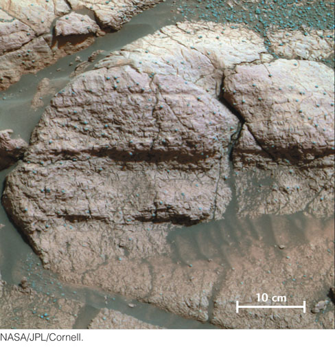
Some of these sedimentary rocks are composed of silicate minerals derived from erosion of old basaltic lavas and the pulverized basaltic rocks of the ancient cratered terrains. For example, the meandering stream deposits visible in Figure 9.21 may have formed largely by the accumulation of basaltic sediments. However, in most, if not all, of the sedimentary rocks beneath Meridiani Planum, where Opportunity has been exploring, sulfate minerals—which are chemical sediments—are mixed with silicate minerals. The sulfate minerals must have been precipitated when water evaporated, probably in shallow lakes or seas. The water must have been very salty to precipitate these minerals, and it must have contained common sulfate minerals such as gypsum (CaSO4). In addition, the presence of unusual sulfate minerals such as jarosite (Figure 9.27)—an iron-rich sulfate mineral—tells us that the water must have been very acidic. On Mars, sulfuric acid probably formed when the abundant basaltic rocks interacted with water and were weathered, releasing their sulfur. The acid-rich water then flowed through rocks, heavily fractured from impacts, and over the surface to accumulate in lakes or shallow seas, where jarosite precipitated as a chemical sediment.
244
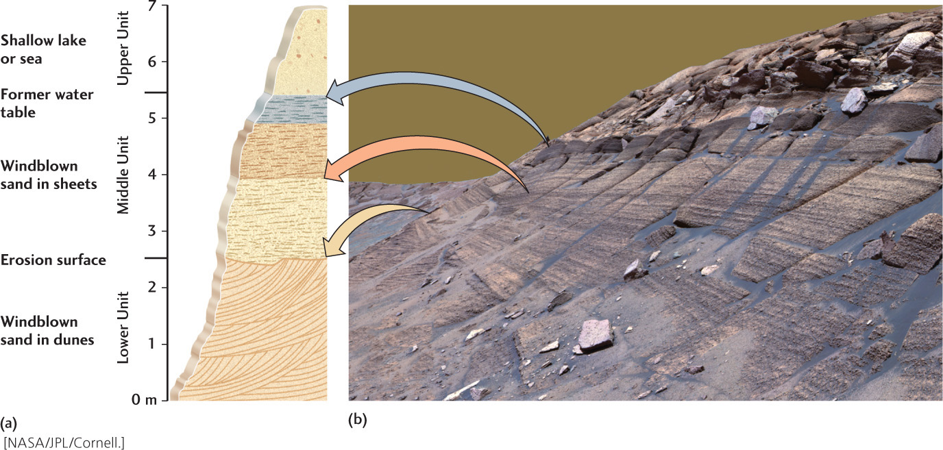
As we have seen in Chapters 5 and 8, sedimentary rocks are valuable records of Earth’s history. The vertical succession of sedimentary rocks—their stratigraphy—tells us how environments change over time. One of the most exciting findings of the Mars Exploration Rovers mission so far has been the discovery of a stratigraphic record at Endurance Crater. Because the crater is so large, there is a lot of outcrop to observe, and it is mostly unaffected by the crater-forming impact. Figure 9.28 shows the outcrop that contains all the stratigraphic clues. By using Opportunity to measure each layer, geologists were able to create a high-resolution stratigraphy (Figure 9.28b), the first of its kind generated for another planet. Remarkably, this interpretive drawing—from a planet 300 million miles away—provides the same level of understanding that is typically obtained here on Earth (as, for example, in Figure 5.15). Curiosity is now doing similar stratigraphic work at Gale crater and also hoping to learn about the time-ordered sequence of events that characterized the early environmental evolution of Mars.
Perhaps one day we will have enough understanding of the stratigraphy of Mars to be able to correlate sedimentary and volcanic rocks from one part of the planet with those from another. To do this, we will need to link observations by the rovers on the ground with observations provided by orbiters overhead. The recent orbiters have shown that sulfates as well as clay minerals are abundant in several places on Mars—particularly in the Vallis Marineris, where they may form deposits up to several kilometers thick. This observation leads us to believe that their formation was related to a process that occurred globally, possibly over a long time. There is some evidence suggesting that the clay minerals may have formed before the sulfate minerals. However, we do not yet know whether these deposits were formed all at the same time, signaling a global environmental event that may have been unique in Mars’s history, or whether they were formed at multiple times in different places. Curiosity’s initial discoveries at Yellowknife Bay, Gale crater, hints at this latter possibility. The conclusion would point to a more common process that operated throughout Mars’s history wherever and whenever local conditions allowed.
245
The evidence is now compelling that at some point in Mars’s history, there was liquid water on its surface and underground. The planet must have been warmer than it is today, unless the water was very short-lived, gushing to the surface briefly, then evaporating quickly or sinking back underground before being frozen, as would happen today. There are many questions left to answer. How much water was there? How long did it last? Did it ever rain, or was it all groundwater leaking to the surface? Did the water last long enough, and have the right composition, to allow life to get started? Only one thing is certain at this point: more missions are required to answer these questions.