Chapter . Map Quiz for Chapter 10

true
true
Chapter 10: African Societies and Kingdoms 1000 b.c.e.–1500 c.e.
Map Quiz for Chapter 10
Map shows Ghana, ca 900-1100 to the west of Sudan and Mali ca 1450 around Ghana to the west, south, and east.  Songhai, ca 1500 is located around Mali to the west, south, and east going to Taghaza in the North and Agades to the east.  There are other states in Yoruba, Oyo, Hausa States, Kanem, Bornu, Ethiopia, Kongo, Zimbabwe, and the Swahili Coast.  The trans-Saharan trade route go through all majore cities in northern Africa along the Sahara desert, including the cities of Moroco, Tripoli, Alexandria, and Cairo.  The coastal trade route goes around the entire coast of Africa and the Arabian peninsula.
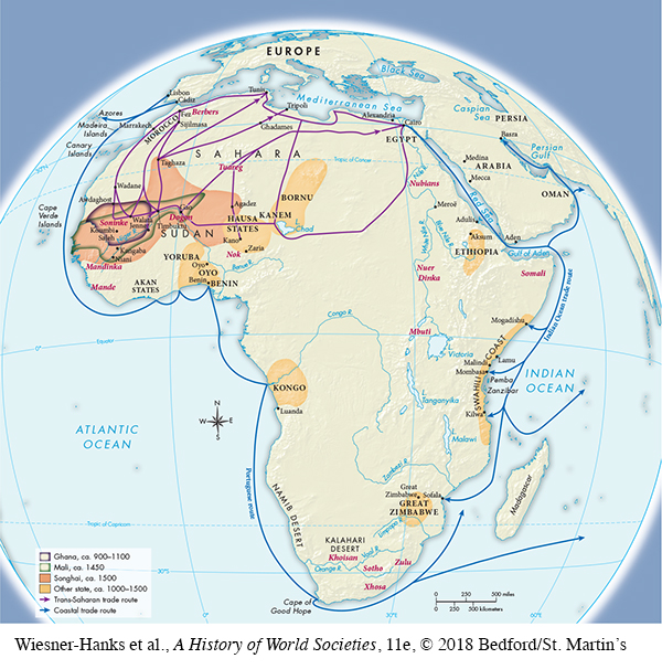
Map of African Kingdoms and Trade, ca. 800–1500

Select the best answer for each question. Click the “Submit” button for each question to turn in your work. Click the "Previous" button to navigate back if you need to view the textbook.

Question

Correct. The answer is B.
Incorrect. The answer is B.
rVe/oCpU+ukwWbALaqykO8XmhjXHLu8Wj9ALlwP43R5y8MFOkYgO7ADH9nOrRp/+MGHPV3Ljastun/9VXgh+eO1+vAGySXfsuwtjrSvj4FK7euMLOR0IeN9I3u1tlfhBEW/Y7BEGVcltbV1mnoFf3OYM3HLN6yFhxxCUsHiaKRoD7w7IfGVAI6rpP1kd7Q7i2HSzOg==

Question

Correct. The answer is D.
Incorrect. The answer is D.
iqFXPhQQZTdbMtAOUUZYjTHUHa7ObEAFuVYDVQ6eH4jX+3TbgSdc9BYnIFElxq0UunzeQTKYqgrvBVHvhEAp/slmI16FclpYC94UkjnUDbYEHJZlkOyS/d/XRKfI8IlfZ8UPPZB3emK78D1sqxuWpyJcifykDwQKhFkZh9xamdH8bJe0BDPDrw==

Question

Correct. The answer is A.
Incorrect. The answer is A.
LbH9D64/4Je0axbaroYqoqyJ7MdJpajXFBEzHiRc/gLHGpbRLxRwZ3rJwTquXIc1hSXzVKCZZ6gdidJXW1IFC52KOvFcpWY83VloIh2c3N5Eh5GPNgT8pVpBE2tS56N+c9ZiCxFrz/2fKJQlWU5+vQx6DcLiyJnE+Bn/YLJil+6dtD/S