114.1 Section Title
true
true
Chapter 13: States and Cultures in East Asia 800–1400
Map Quiz for Chapter 13
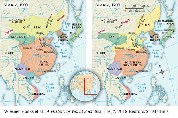
Map of East Asia in 1000 and 1200
Select the best answer for each question. Click the “Submit” button for each question to turn in your work. Click the "Previous" button to navigate back if you need to view the textbook.
1 of 3
Correct. The answer is A.
Incorrect. The answer is A.
rsZFbrVDqmK4kWvaVvnJ+WVp07ikUAFh8EGC6HgYOKkT82XJgSYv/VEEcvCc8NQEHiPHpn1ppCYxVtIIbMSQsuGcEBnmJbzdMvbb18jWvAMXHXi7WzPvN883Q7/RNFwgTrKwq1hNfr0T2KGYd3tqNq2y7QEajmq/In0E4xjgt2dM2Nz9O6Q66i9D4QUBhO/hypSrNJMNp7nwtw9/opphbCE0hDk=
2 of 3
Correct. The answer is D.
Incorrect. The answer is D.
hsHLTS8PNvhIugY8oxm/RoaoqzvNawndUaHYce2q2suMus2yznnLT0lyPLh933auVJboyZ/aaHbTUJ5NKgmtEfb9gXcM2rEIzCohPZbPLC/w5+ZZHsaIsUrSxaRLxG/t6DacHcGw1An1uNO/HEc404/4mk1vyTQmfLoUjlNtRbiyYeLg+7fQKBkQUsTvpwxO2ku2w9vUv0pYsnmOaLixgGvSsMENcUEGIromTKeqryB6rr8oVbn2ZZuTLWY9msg66aJjNTGbhTZSzL2h/I7W6pPeJsoXzO0b9k03HHWntqkND+2a8NG83vPikMJTvhkcALYB+KkYSxp6trIaJ/yYiiWlUsD8kfFCTAKMsN5Oc+e7PEMFx61H7g==
3 of 3
Correct. The answer is B.
Incorrect. The answer is B.
KkFIgOWn39xuhDue+s7VfxwjXfVJzcLAYkimVo4QdBv9a+ItoSxBmz2tDO9kfbZDr8yyrmlUvv9OsVT0cILn07x2MdVB0xSr4Ljf8oXTNdBSmCVhy6MeGZOqTY9H0K9uJ3uuVRlwVXOIxwtDy4oW4sKv4kLD2THZ/S+gVL6iMb2nZBvMPbh1ZYXj+hk=