1-1 The night sky is full of patterns
When you gaze at the sky on a clear night, where the air is free of pollution and there is not too much light from cities or other sources, there seem to be millions of stars twinkling overhead. In reality, the unaided human eye can detect only about 6000 stars over the entire sky. At any one time, you can see roughly 3000 stars in dark skies, because only half of the stars are above the horizon—the boundary between Earth and the sky. In very smoggy or light-polluted cities, you may see only a tenth of that number or less (Figure 1-1).
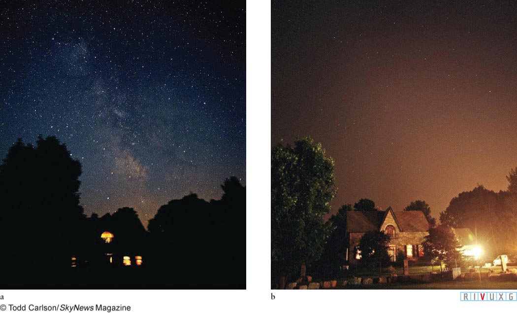
Figure 1-1:  The Night Sky Without and With Light Pollution (a) Sunlight is a curtain that hides virtually everything behind it. As the Sun sets, places with little smog or light pollution treat viewers to beautiful panoramas of stars that can inspire the artist or scientist in many of us. This photograph shows the night sky in Goodwood, Ontario, Canada, during a power outage. (b) This photograph shows the same sky with normal city lighting.
 In any event, you probably have noticed patterns of bright stars, each formally called an asterism, and you are familiar with some common names for some of them, such as the ladle-shaped Big Dipper and broad-shouldered Orion. These recognizable patterns of stars (Figure 1-2a) are informally called constellations in everyday conversation. Technically, however, each constellation is an entire region of the sky and everything in that region. In what follows, we will often use the word “constellation” to mean either the asterisms or the regions of the sky. The context will tell you which version of the word is in use.
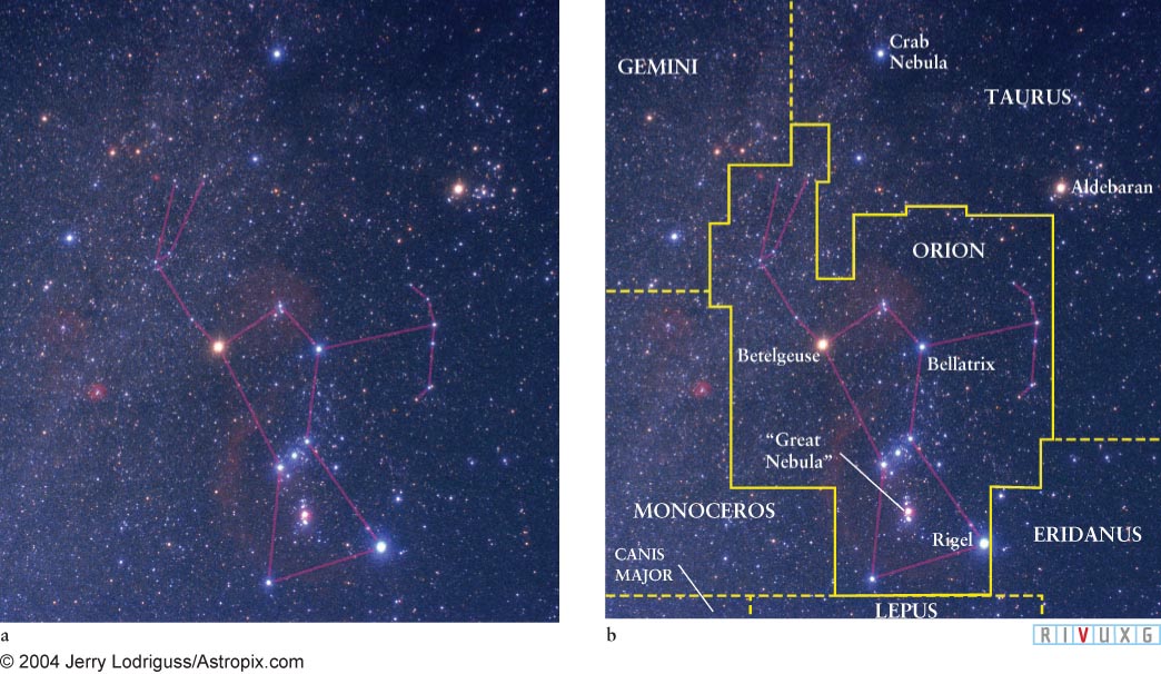
Figure 1-2:
The Constellation Orion (a) The pattern of stars (asterism) called Orion is prominent in the winter sky. From the northern hemisphere, it is easily seen high above the southern horizon from December through March. You can see in this photograph that the various stars have different colors—something to watch for when you observe the night sky. (b) Technically, constellations are entire regions of the sky. The constellation called Orion and parts of other nearby constellations are depicted in this photograph. All the stars and other celestial objects, like galaxies, inside the boundary of Orion are members of that constellation. The entire sky is covered by a quiltlike pattern of 88 constellations of differing sizes and shapes.
1-2 Constellations make locating stars easy
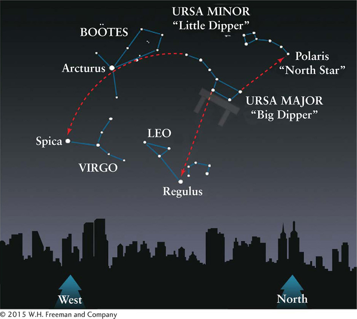
Figure 1-3: The Big Dipper as a Guide In the northern hemisphere, the Big Dipper is an easily recognized pattern of seven bright stars. This star chart shows how the Big Dipper can be used to locate Polaris (the North Star) as well as the brightest stars in three other constellations. While the Big Dipper appears right side up in this drawing of the sky shortly before sunrise, at other times of the night it appears upside down.
 People have known for millennia how to find the direction north in locations where the Big Dipper is visible. To do this, locate the Big Dipper (the asterism in the constellation Ursa Major) and imagine that its bowl is resting on a table (Figure 1-3). If you see the dipper upside down in the sky, as you frequently will, imagine the dipper resting on an upside-down table above it. Locate the two stars of the bowl farthest from the Big Dipper’s handle. These are called the pointer stars. Draw a mental line through these stars in the direction away from the table, as shown in Figure 1-3. The first moderately bright star you then encounter is Polaris, also called the North Star because it is located almost directly over Earth’s North Pole. So, while Polaris is not even among the 20 brightest stars (see Appendix G: The Visually Brightest Stars), it is easy to locate. Whenever you face Polaris, you are facing north. East is then on your right, south is behind you, and west is on your left. (There is no equivalent star over the South Pole.)
Focus Question 1-1
Referring to Figure 1-5, can you create a story to help you remember the connections between the constellations Cygnus (the Swan), Sagitta (the Arrow), and Aquila (the Eagle)?
The Big Dipper also illustrates the fact that being familiar with just a few prominent constellations makes it easy to locate less distinctive constellations and their important stars. The most effective way to do this is to use vivid visual connections. For example, imagine gripping the handle of the Big Dipper and slamming its bowl straight down onto the head of Leo (the Lion). Leo comprises the first group of bright stars your dipper encounters. As shown in Figure 1-3, the brightest star in this group is Regulus, the dot of the backward question mark that traces the lion’s mane. As another example, follow the arc of the Big Dipper’s handle away from its bowl. The first bright star you encounter along that arc beyond the handle is Arcturus in Boötes (the Herdsman). Follow the same arc farther to the prominent bluish star Spica in Virgo (the Virgin). Spotting these stars and remembering their names are easy if you remember the saying “Arc to Arcturus and speed on to Spica.”
Different constellations are visible at night during different times of the year. During the winter months in the northern hemisphere, you can see some of the brightest stars in the sky. Many of them are in the vicinity of the “winter triangle,” which connects bright stars in the constellations of Orion (the Hunter), Canis Major (the Larger Dog), and Canis Minor (the Smaller Dog), as shown in Figure 1-4. The winter triangle passes high in the sky at night during the middle of winter. It is easy to find Sirius, the brightest star in the night sky, by locating the belt of Orion and following a straight mental line from it to the left (as you face Orion). The first bright star that you encounter is Sirius.
Insight Into Science
Compare What You Believe with What Nature and Science Show You If you thought Polaris is the brightest star in the night sky, how did you learn that? There is likely to be a lot of information you learned from a variety of sources that you will have to unlearn while learning astronomy. While this process is often uncomfortable, it is essential if you want to understand how science works and how scientists view the world. Be careful: It is human nature to change new information to fit our current beliefs rather than change what we believe. Fight that urge if science can show you that your beliefs are incorrect!
The “summer triangle,” which graces the summer sky as shown in Figure 1-5, connects the bright stars Vega in Lyra (the Lyre), Deneb in Cygnus (the Swan), and Altair in Aquila (the Eagle). A conspicuous portion of the Milky Way forms a beautiful background for these constellations, which are nearly overhead in the northern hemisphere during the middle of summer at midnight.
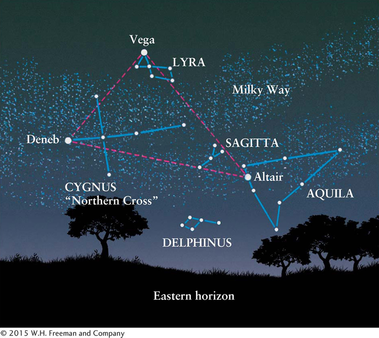
Figure 1-5: The Summer Triangle This star chart shows the northeastern sky as it appears in the evening in June. In addition to the three constellations involved in the summer triangle, the faint stars in the constellations Sagitta (the Arrow) and Delphinus (the Dolphin) are also shown.
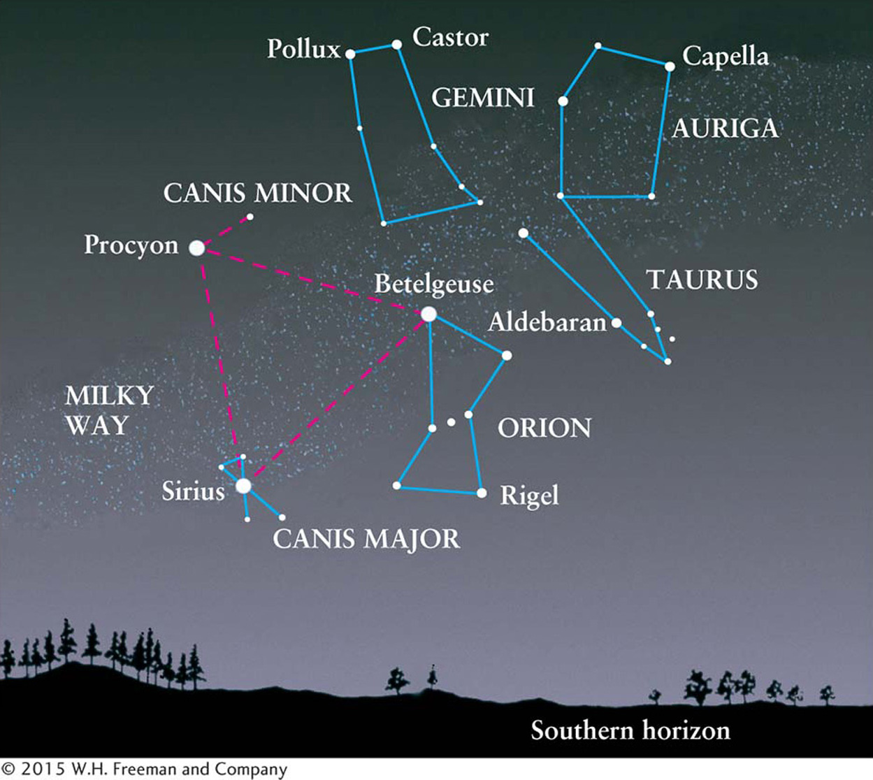
Figure 1-4: The Winter Triangle This star chart shows the southern sky in the northern hemisphere as it appears during the evening in December. Three of the brightest stars in the sky make up the winter triangle. In addition to the constellations involved in the triangle, Gemini (the Twins), Auriga (the Charioteer), and Taurus (the Bull) are also shown.
1-3 The celestial sphere aids in navigating the sky
Astronomers require more accuracy in locating dim objects than is possible simply by moving from asterism to asterism. They have therefore created a sky map, called the celestial sphere, and applied a coordinate system to it, analogous to the coordinate system of north-south latitude and east-west longitude used to navigate on Earth. If you know a star’s celestial coordinates and know how to navigate around the night sky, you can locate it quickly. For such a sky map to be useful in finding stars, the stars must be fixed on it, just as cities are fixed on maps of Earth. If you look at the night sky year after year, you will see that the stars do indeed appear fixed relative to one another. Furthermore, throughout each night, entire patterns of stars appear to rigidly orbit Earth in fixed groups. We employ this artificial, Earth-based view of the heavens to make celestial maps by pretending that the stars are attached to the inside of an enormous hollow shell, the celestial sphere, with Earth at its center (Figure 1-6a). Visualized another way, you can imagine the half of the celestial sphere that is visible at night as a giant dome covering Earth (Figure 1-6b).
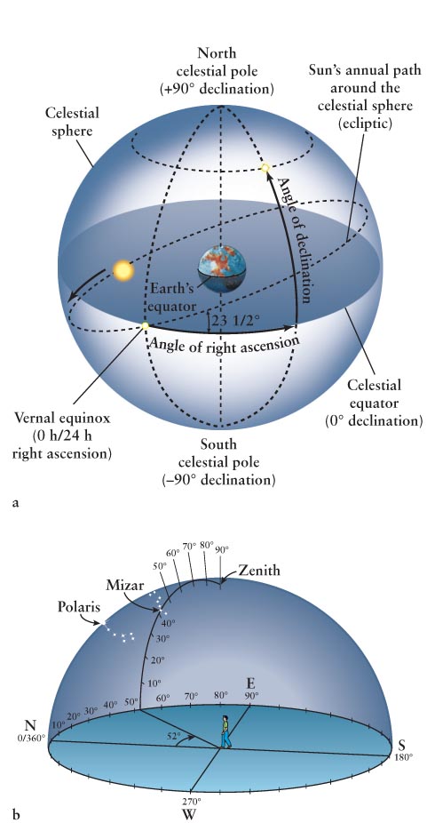
Figure 1-6: The Celestial Sphere and Coordinate Systems (a) The celestial sphere is the apparent “bowl” or hollow sphere of the sky. The celestial equator and poles are projections of Earth’s equator and axis of rotation onto the celestial sphere. The north celestial pole is therefore located directly over Earth’s North Pole, while the south celestial pole is directly above Earth’s South Pole. Analogous to longitude and latitude on Earth, the coordinates in space are right ascension (R.A.) and declination (Dec.), respectively. The star in this figure has the indicated R.A. and Dec. (b) Altitude and azimuth create a local coordinate system for every place on Earth. Altitude is the angle straight up from the horizon. Azimuth is the angle eastward from north along the horizon. To find Mizar at 10 p.m. on March 14, 2013, as seen from Orono, Maine, we calculate its coordinates there as altitude 47° and azimuth 52° and use them to locate it in the night sky.
The 88 constellations that completely cover the sky are each formed around an asterism, which is why the constellations and their asterisms have the same names. These constellations were chosen in 1922 by the American astronomer Henry Norris Russell and their boundaries (see Figure 1-2b) were set in 1930 by the Belgian astronomer Eugene Delporte. This work was done under the auspices of the International Astronomical Union (IAU).
Some constellations, like Ursa Major (the Large Bear), are very large, while others, like Sagitta, are relatively small. To describe a star’s location, we might say “Albireo in the constellation Cygnus,” much as we would refer to “Chicago in the state of Illinois,” “Melbourne in the state of Victoria,” or “Ottawa in the province of Ontario.”
The stars seem fixed on the celestial sphere only because of their remoteness. Stars are actually at a wide variety of distances from Earth, and they are moving relative to each other. But we neither see their motion nor perceive their relative distances because they are so far from us. You can understand this difficulty in seeing distant objects moving by first imagining a car driving right past you at 100 km/h (62 mi/h). Its motion is unmistakable. However, a plane traveling at 1000 km/h across the sky appears to be moving much more slowly. And an object at the distance of the Sun traveling at the same speed as the plane across the sky would appear to be going nearly 100 million times more slowly than that plane.
The stars (other than the Sun) are all more than 40 × 1012 km (40 trillion km or 25 trillion mi) from us. Therefore, although the patterns of stars in the sky do change, their great distances prevent us from seeing those changes over the course of a human lifetime. Thus, as unrealistic as it is to assume that all the stars are fixed in space and that all are at the same distance from us, the celestial sphere is so useful for navigating the heavens that it is used by astronomers even at the most sophisticated observatories around the world.
As shown in Figure 1-6a, we can project key geographic features from Earth out into space to establish directions and bearings. If we expand Earth’s equator onto the celestial sphere, we obtain the celestial equator, which divides the sky into northern and southern hemispheres, just as Earth’s equator divides Earth into two hemispheres. We can also imagine projecting a straight line between Earth’s North Pole and South Pole out into space above both poles. Where this line intersects the celestial sphere defines the north celestial pole and the south celestial pole, also shown in Figure 1-6a.
Using the celestial equator and poles as reference features, astronomers divide up the surface of the celestial sphere in precisely the same way that the latitude and longitude grid divides Earth. The equivalent to latitude on Earth is called declination (Dec.) on the celestial sphere. It is measured from 0° to 90° north or south of the celestial equator. The equivalent of longitude on Earth is called right ascension (R.A.) on the celestial sphere, measured in hours from 0 h to 24 h around the celestial equator (see Figure 1-6a). We derive the reference point (0 h) of right ascension, analogous to Earth’s prime meridian, shortly. The boundaries of the constellations all meet at right angles and run along lines of constant right ascension and constant declination. Because stars are all so far away, their R.A. and Dec. do not change perceptibly over our lifetime (except as measured in modern observatories, which can detect changes for some of the nearer ones).
1-4 An “alt”ernative coordinate system
Just as latitude and longitude can take us any place on Earth, right ascension and declination are a coordinate system for the entire celestial sphere. If you know the R.A. and Dec. for a given object and know how to navigate around the celestial sphere (that is, if you know the angle for the object from the celestial equator and the angle around the celestial equator from the equivalent of the prime meridian on the sky), you can find that object’s location in the night sky. The problem is that without lots of experience and/or the appropriate software at hand, figuring out the coordinate system on the night sky and locating that object can be difficult. There is an alternative, local coordinate system that often expedites navigating around the night sky, called the alt-azimuth or altazimuth coordinate system.
The alt-azimuth system (Figure 1-6b) depends on your location and the time of night. It is easy to use: First find the North Pole star, Polaris (see Section 1-2). Facing the direction of Polaris, you are facing due north. Look straight at the horizon below Polaris. This is (0°, 0°) in the alt-azimuth system. (Recall that ° denotes the angular measure of degrees. There are 360° in a circle.) Altitude is the angle straight up from the horizon toward your zenith, the point directly overhead. (Every place has a different zenith.) Altitude runs between 0° at the horizon and 90° at the zenith. The angle to the right of north along the horizon is the azimuth coordinate for your position. For example, the azimuth of east is 90°, while the azimuth of south is 180°. Azimuth ranges from 0° to 360°. Figure 1-6b shows how to find Mizar, the middle star in the handle of the Big Dipper, given its altitude and azimuth at a certain location and time.
Because Earth spins on its axis, every object on the celestial sphere is continuously moving from our perspective, so while their R.A. and Dec. are constant, their altitude and azimuth angles are continually changing. Software like Starry Night™ can calculate the altitude and azimuth for any object, and because it is very easy to use the alt-azimuth system, as just described, these coordinates are frequently used in astronomy labs at schools and colleges.
1-5 Earth orbits the Sun in a plane called the ecliptic
Imagine that you could see the stars even during the day, so that you could follow the Sun’s motion through the background constellations throughout the year. (The Sun appears to move among the stars because Earth orbits around it.) From day to day, you would see the Sun trace a straight path on the celestial sphere called the ecliptic. As you can see in Figure 1-7a, the ecliptic makes a closed circle bisecting the celestial sphere. Every year the Sun follows the same course through the sky because Earth follows the same path around it.
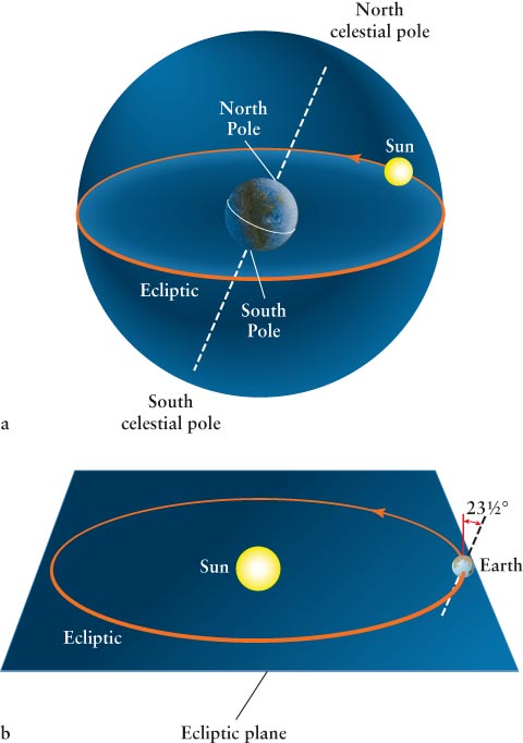
Figure 1-7: The Ecliptic (a) The ecliptic is the apparent annual path of the Sun on the celestial sphere. (b) The ecliptic is also the plane described by Earth’s path around the Sun. The planes created by the two ecliptics exactly coincide. Note that the rotation axis through Earth’s poles is tilted 23½° from being perpendicular to the ecliptic.
The term “ecliptic” has a second use in astronomy. Earth orbits the Sun in a plane also called the ecliptic (Figure 1-7b). Imagine yourself on the Sun watching Earth move day by day. The path of Earth on the celestial sphere as seen from the Sun is precisely the same as the path of the Sun as seen from Earth. In other words, the plane created by the Sun’s path on the celestial sphere and the plane of Earth’s orbit are identical. Hence, the two ecliptics are the same.
Note in both parts of this figure that Earth’s axis of rotation, running through the North Pole and South Pole, is tilted relative to the ecliptic by 23½°. Because of this tilt, the celestial equator and the path of the Sun around the celestial sphere are tilted with respect to each other by that angle, as shown in Figure 1-6a. Because of this tilt, the two loops meet in two places. Where the Sun is heading northward, this intersection is called the vernal equinox. Halfway around the two circles they meet again at the autumnal equinox. At this time, the Sun is heading southward. Equinox comes from the Latin words meaning “equal night,” because when the Sun appears at either of these two points, it is directly over Earth’s equator, resulting in 12 hours of daytime and 12 hours of nighttime everywhere on Earth on that day. Just as the location of Greenwich, England, defines the prime meridian, or zero of longitude on Earth, we need to establish a zero of right ascension. This zero value is defined to be at the vernal equinox (see Figure 1-6a).
In navigating around the celestial sphere, astronomers measure the relative positions of two objects by the angle between them. Ancient mathematicians invented a system of angles and angular measure that is still used today to denote the relative positions and apparent sizes of objects in the sky. To locate stars on the celestial sphere, for example, we do not need to know their distances from Earth. All we need to know is the angle from one star to another in the sky, a property that remains fixed over our lifetimes because the stars are all so far away.
An arc angle, often just called an angle, is the opening between two lines that meet at a point. Angular measure is a method of describing the size of an angle. As noted earlier, the basic unit of angular measure is the degree, designated by the symbol °. A full circle is divided into 360°. A right angle measures 90°. As shown in Figure 1-8, the angle between the two “pointer stars” in the Big Dipper is about 5°.
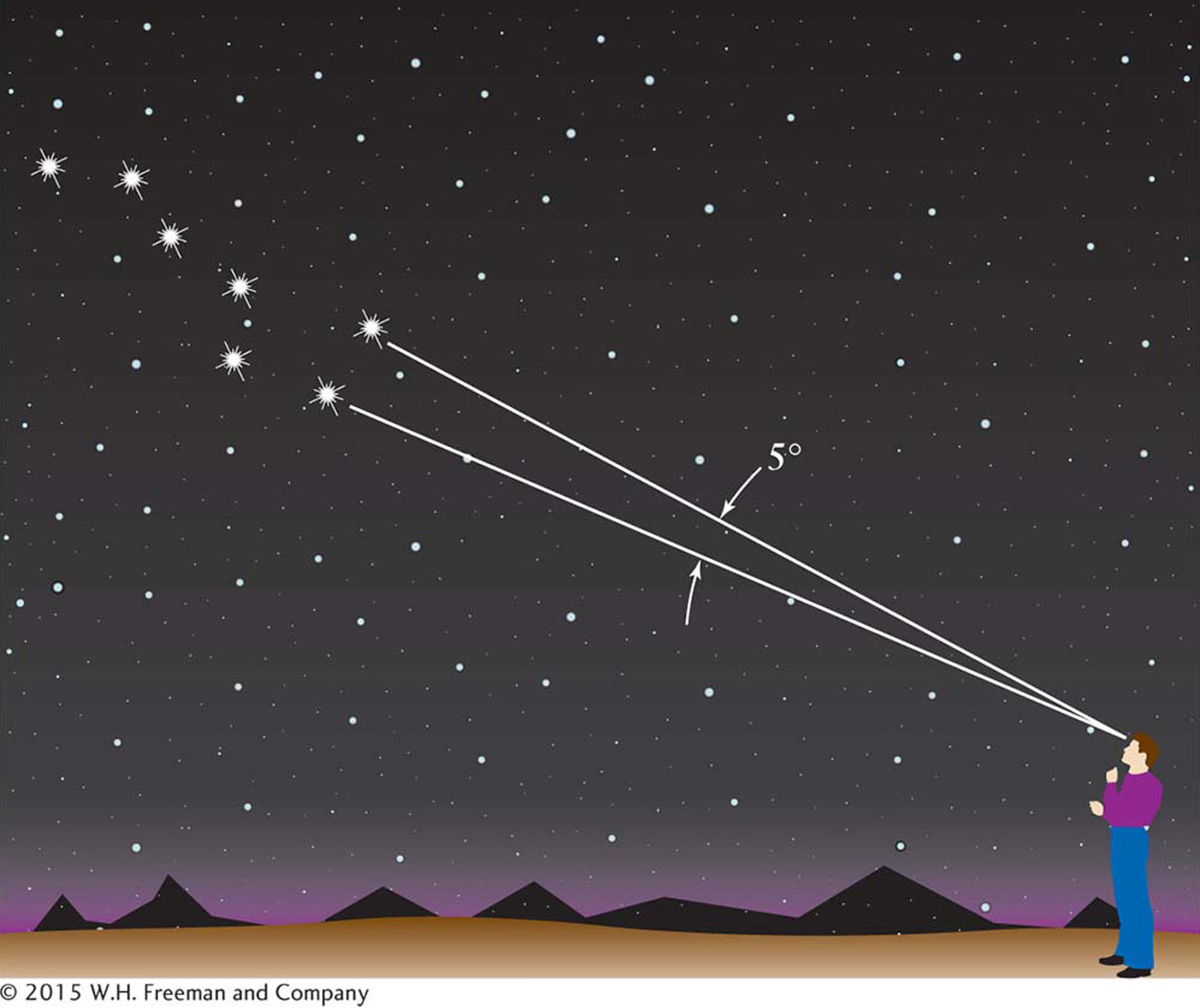
Figure 1-8: The Big Dipper The angular distance between the two “pointer stars” at the front of the Big Dipper is about 5°. For comparison, the angular diameter of the Moon is about ½°.
Astronomers also use angular measure to describe the apparent sizes of celestial objects. For example, imagine the full Moon. As seen from Earth, the angle across the Moon’s diameter is nearly ½°. We therefore say that the angular diameter, or angular size, of the Moon is ½°. Alternatively, astronomers say that the Moon “subtends” an angle of ½°. In this context, subtend means “to extend across.”
To talk about smaller angles, we subdivide the degree into 60 arcminutes (abbreviated 60 arcmin or 60′). An arcminute is further subdivided into 60 arcseconds (abbreviated 60 arcsec or 60″). A dime viewed face-on from a distance of 1.6 km (1 mile) has an angular diameter of about 2″. From everyday experience, we know that an object looks bigger when it is nearby than when it is far away. The angular size of an object therefore does not by itself tell you anything about its actual physical size. For example, the fact that the Moon’s angular diameter is ½° does not tell you how big the Moon really is. Nor does the Sun’s angular size alone tell you how far it is from Earth.