module 24 Mineral Resources and Geology
261
Almost all of the mineral resources on Earth accumulated when the planet formed 4.6 billion years ago. But Earth is a dynamic planet. Earth’s geologic processes form and break down rocks and minerals, drive volcanic eruptions and earthquakes, determine the distribution of scarce mineral resources, and create the soil in which plants grow. In this module we will examine the distribution of Earth’s mineral resources and some of the geological processes that continue to affect this distribution.
Learning Objectives
After reading this module you should be able to
describe the formation of Earth and the distribution of critical elements on Earth.
define the theory of plate tectonics and discuss its relevance to the study of the environment.
describe the rock cycle and discuss its importance in environmental science.
The availability of Earth’s resources was determined when the planet was formed
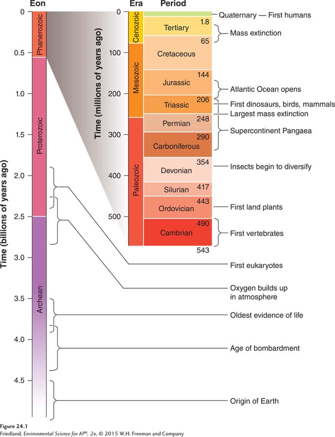
Earth’s history is measured using the geologic time scale, shown in FIGURE 24.1. It’s hard to believe that events that took place 4.6 billion years ago continue to have such an influence on humans and their interactions with Earth. The distribution of chemicals, minerals, and ores around the world is in part a function of the processes that occurred during the formation of Earth.
The Formation and Structure of Earth
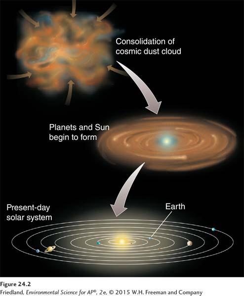
Nearly all the elements found on Earth today are as old as the planet itself. FIGURE 24.2 illustrates how Earth formed roughly 4.6 billion years ago from cosmic dust in the solar system. The early Earth was a hot, molten sphere. For a period of time, additional debris from the formation of the Sun bombarded Earth. As this molten material slowly cooled, the elements within it separated into layers according to their mass. Heavier elements such as iron sank toward Earth’s center, and lighter elements such as silica floated toward its surface. Some gaseous elements left the solid planet and became part of Earth’s atmosphere. Although asteroids occasionally strike Earth today, the bombardment phase of planet formation has largely ceased and the elemental composition of Earth has stabilized. In other words, the elements and minerals that were present when the planet formed—
Some minerals such as silicon dioxide—
262
Core The innermost zone of Earth’s interior, composed mostly of iron and nickel. It includes a liquid outer layer and a solid inner layer.
Mantle The layer of Earth above the core, containing magma.
Magma Molten rock.
Asthenosphere The layer of Earth located in the outer part of the mantle, composed of semi-
Lithosphere The outermost layer of Earth, including the mantle and crust.
Crust In geology, the chemically distinct outermost layer of the lithosphere.
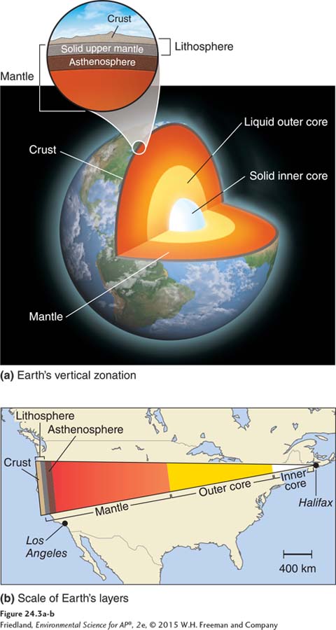
Because Earth’s elements settled into place according to their mass, the planet is characterized by distinct vertical zonation. If we could slice into Earth as shown in FIGURE 24.3 we would see concentric layers composed of various materials. The innermost zone is the planet’s core, over 3,000 km (1,860 miles) below Earth’s surface. The core is a dense mass largely made of nickel and some iron. The inner core is solid, and the outer core is liquid. Above the core is the mantle, containing molten rock, or magma, that slowly circulates in convection cells, much as the atmosphere does. The asthenosphere, located in the outer part of the mantle, is composed of semi-
263
The lithosphere is made up of several large and numerous smaller plates, which overlie the convection cells within the atmosphere. Over the crust lies the thin layer of soil that allows life to exist on the planet. The crust and overlying soil provide most of the chemical elements that make up life.
Because Earth contains only a finite supply of mineral resources, we will not be able to extract resources from the planet indefinitely. In addition, once we have mined the deposits of resources that are most easily obtained, we must use more energy to extract the remaining resources. Both of these realities provide an incentive for us to minimize our use of mineral resources and to reuse and recycle them whenever possible.
Hot Spots
Hot spot In geology, a place where molten material from Earth’s mantle reaches the lithosphere.
One of the critical consequences of Earth’s formation and elemental composition is that the planet remains very hot at its center. The high temperature of Earth’s outer core and mantle is thought to be the result of the radioactive decay of various isotopes of elements such as potassium, uranium, and thorium, which release heat. The heat causes plumes of hot magma to well upward from the mantle. These plumes produce hot spots: places where molten material from the mantle reaches the lithosphere. As we shall see in the following pages, hot spots are an important component of the surface dynamics of Earth.
264
The theory of plate tectonics describes the movement of the lithosphere
Prior to the 1900s, scientists believed that the major features of Earth—
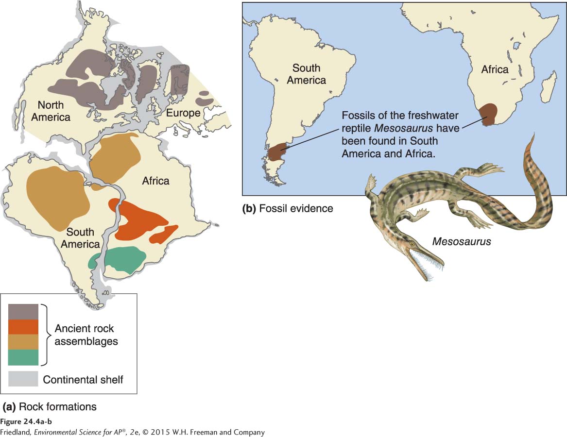
Plate tectonics The theory that the lithosphere of Earth is divided into plates, most of which are in constant motion.
Tectonic cycle The sum of the processes that build up and break down the lithosphere.
Many resisted the idea that Earth’s lithosphere could move laterally. However, following the publication of Wegener’s hypothesis, scientists found additional evidence that Earth’s landmasses had existed in several different configurations over time. This led to the theory of plate tectonics, which states that Earth’s lithosphere is divided into plates, most of which are in constant motion. The tectonic cycle is the sum of the processes that build up and break down the lithosphere.
The theory of plate tectonics is often called a unifying theory in geology and earth sciences because it relates to so many different aspects of the earth sciences.
Plate Movement
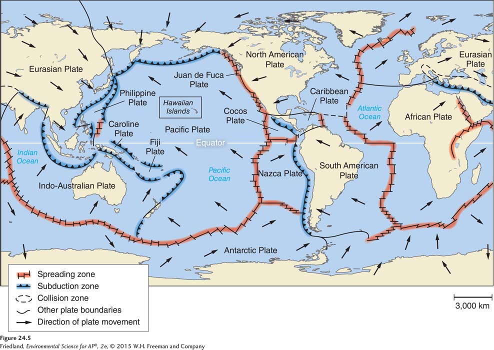
We now know that the lithosphere consists of a number of plates. Oceanic plates lie primarily beneath the oceans, whereas continental plates lie beneath landmasses. The crust of oceanic plates is dense and rich in iron, while the crust of continental plates generally contains more silicon dioxide, which is much less dense than iron. The continental plates are therefore lighter and typically rise above the oceanic plates. FIGURE 24.5 identifies Earth’s major plates.
265
Subduction The process of one crustal plate passing under another.
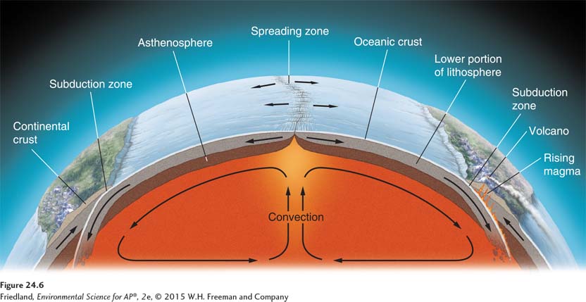
Oceanic and continental plates “float” on top of the denser material beneath them. Their slow movements are driven by convection cells in Earth’s mantle. The heat from Earth’s core creates these convection cells, which are similar to those in the atmosphere. (See FIGURE 10.6 on page 115.) Mantle convection drives continuous change: the creation and renewal of Earth materials in some locations of the lithosphere and destruction and removal of Earth material in other locations. As oceanic plates move apart, rising magma forms new oceanic crust on the seafloor at the boundaries between those plates. This process, called seafloor spreading, is shown in the center of FIGURE 24.6. Where oceanic plates meet continental plates, old oceanic crust is pulled downward beneath the continental lithosphere, removed from the ocean bottom, and pushed toward the center of Earth. In this process, the heavier oceanic plate slides underneath the lighter continental plate. This is best seen on the left side of FIGURE 24.6. This process of one plate passing under another is known as subduction.
266
Consequences of Plate Movement
Because the plates move, continents on those plates slowly drift over the surface of Earth. As the continents have drifted, their climates have changed and geographic barriers were formed or removed, and as a result, species evolved and adapted, or slowly or rapidly went extinct. In some places, as the plates moved a continent that straddled two plates broke apart, creating two separate smaller continents or islands in different climatic regions. As you may recall from our discussion of allopatric speciation in Chapter 5, species that become separated can take different evolutionary paths and over time evolve into two or more separate species. The fossil record tells us how species adapted to the changes that took place over geologic time. Climate scientists and ecologists can use this information to anticipate how species will adapt to the relatively rapid climate changes happening on Earth today.
Volcano A vent in the surface of Earth that emits ash, gases, or molten lava.
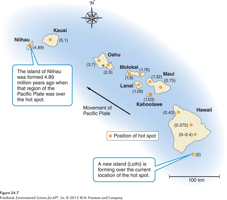
Although the rate of plate movement is too slow for us to notice, geologic activity provides vivid evidence that the plates are in motion. As a plate moves over a geologic hot spot, heat from the rising mantle plume melts the crust, forming a volcano: a vent in Earth’s surface that emits ash, gases, and molten lava. Volcanoes are a natural source of atmospheric carbon dioxide, particulates, and metals. Over time, as the plate moves past the hot spot, it can leave behind a trail of extinct volcanic islands, each with the same chemical composition. The Hawaiian Islands, shown in FIGURE 24.7, are an excellent example of this pattern.
Types of Plate Contact
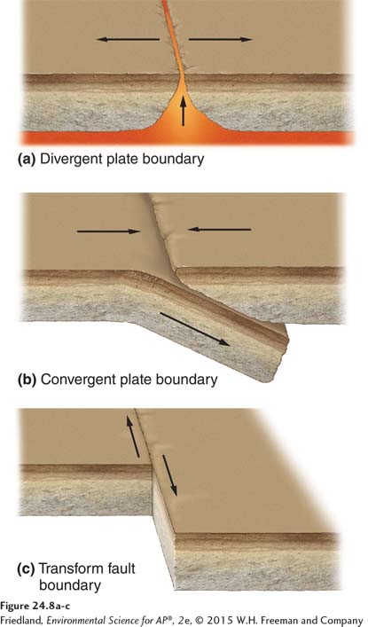
Many other geologic events occur at the zones of contact that result from the movements of plates relative to one another. These zones of plate contact can be classified into three types: divergent plate boundaries, convergent plate boundaries, and transform fault boundaries.
Divergent plate boundary An area beneath the ocean where tectonic plates move away from each other.
Seafloor spreading The formation of new ocean crust as a result of magma pushing upward and outward from Earth’s mantle to the surface.
Beneath the oceans, plates move away from each other at divergent plate boundaries, as illustrated in FIGURE 24.8a. At these boundaries, oceanic plates move apart as if on a giant conveyer belt. As magma from the mantle reaches Earth’s surface and pushes upward and outward, new rock is formed, a phenomenon, called seafloor spreading. Seafloor spreading creates new lithosphere and brings important elements such as copper, lead, and silver to the surface of Earth. However, this new rock typically lies under the deep ocean. Over tens to hundreds of millions of years, as the tectonic cycle continues, some of that material forms new land that contains these valuable resources.
267
Convergent plate boundary An area where plates move toward one another and collide.
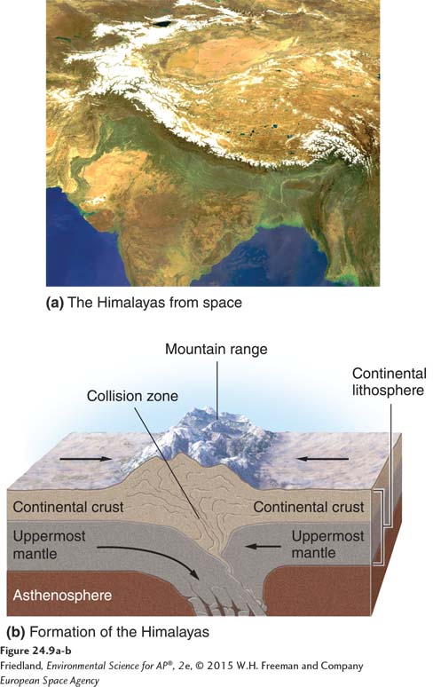
Clearly, if tectonic plates are diverging in one place, and if the surface of Earth has a finite area, the plates must be moving together somewhere else. Convergent plate boundaries form where plates move toward one another and collide, as shown in FIGURE 24.8b. The plates generate a great deal of pressure as they push against one another.
Transform fault boundary An area where tectonic plates move sideways past each other.
Fault A fracture in rock caused by a movement of Earth’s crust.
Seismic activity The frequency and intensity of earthquakes experienced over time.
Fault zone A large expanse of rock where a fault has occurred.
When plates move sideways past each other, the result is a transform fault boundary, shown in FIGURE 24.8c. A fault is a fracture in rock across which there is movement. Where this occurs, it is said that there is a high level of seismic activity, which is the frequency and intensity of earthquakes experienced over time. A fault zone is a large expanse of rock where a fault has occurred. Fault zones—
If two continental plates meet, both plate margins may be lifted, forming a mid-
Most plates and continents move at about the same rate as your fingernails grow: roughly 36 mm, or 1.4 inches, per year. While this movement is far too slow to notice on a daily basis, the two plates underlying the Atlantic Ocean have spread apart and come together twice over the past 500 million years, causing Europe and Africa to collide with North America and South America and separate from them again. “Do the Math: Plate Movement” shows how we can calculate the time it takes for plates to move.
268
Faults, Earthquakes, and Volcanoes
Earthquake The sudden movement of Earth’s crust caused by a release of potential energy along a geologic fault and usually causing a vibration or trembling at Earth’s surface.
Epicenter The exact point on the surface of Earth directly above the location where rock ruptures during an earthquake.
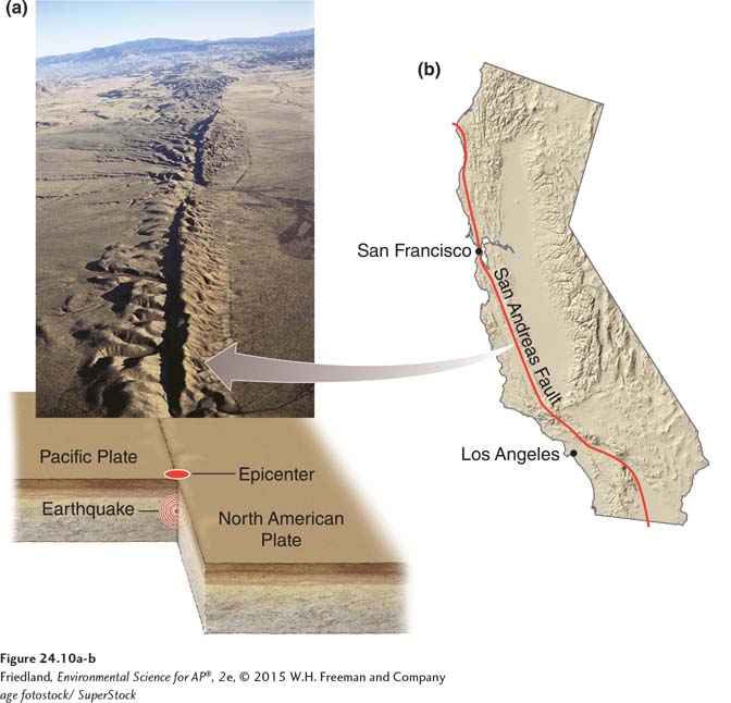
Although the plates are always in motion, their movement, while generally slow, is not necessarily smooth. Imagine rubbing two rough and jagged rocks past each other. The rocks would resist that movement and get stuck together. The rock along a fault is also jagged and thus resists movement, but the mounting pressure eventually overcomes the resistance and the plates give way, slipping quickly. This is an earthquake, which is a sudden movement of Earth’s crust caused by the release of potential energy along a fault, causing vibration or movement at the surface. Earthquakes occur when the rocks of the lithosphere rupture unexpectedly along a fault. The plates can move up to several meters in just a few seconds. Earthquakes are common in fault zones, which are areas of seismic activity. FIGURE 24.10 shows one such area, the San Andreas Fault in California, which is a transform fault. The epicenter of an earthquake is the exact point on the surface of Earth directly above the location where the rock ruptures, also shown in FIGURE 24.10.
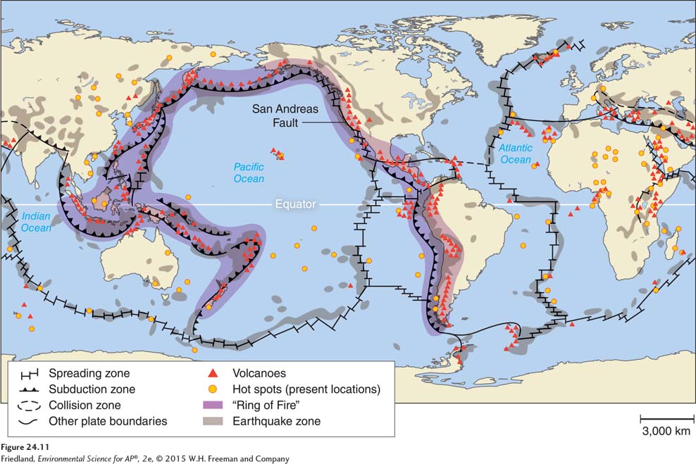
Earthquakes are a direct result of the movement of plates and their contact with each other. Volcanic eruptions happen when molten magma beneath the crust is released to the atmosphere. Sometimes the two events are observed together, most often along plate boundaries where tectonic activity is high. FIGURE 24.11 shows one example, in which earthquake locations and volcanoes form a circle of tectonic activity, called the “Ring of Fire,” around the Pacific Ocean.
The Environmental and Human Toll of Earthquakes and Volcanoes
269
Plate movements, volcanic eruptions, seafloor spreading, and other tectonic processes bring molten rock from deep beneath Earth’s crust to the surface, and subduction sends surface crust deep into the mantle. This tectonic cycle of surfacing and sinking is a continuous Earth process. When humans live in close proximity to areas of seismic or volcanic activity, however, the results can be dramatic and devastating.
Richter scale A scale that measures the largest ground movement that occurs during an earthquake.
Earthquakes occur many times a day throughout the world, but most are so small that humans do not feel them. The magnitude of an earthquake is reported on the Richter scale, a measure of the largest ground movement that occurs during an earthquake. The Richter scale, like the pH scale described in Chapter 2, is logarithmic. On a logarithmic scale, a value increases by a factor of 10 for each unit increase. Thus a magnitude 7.0 earthquake, which causes serious damage, is 10 times greater than a magnitude 6.0 earthquake and 1,000 (103) times greater than a magnitude 4.0 earthquake, which only some people can feel or notice. Worldwide, there may be as many as 800,000 small earthquakes of magnitude 2.0 or less per year, but an earthquake of magnitude 8.0 occurs approximately once every year.
270
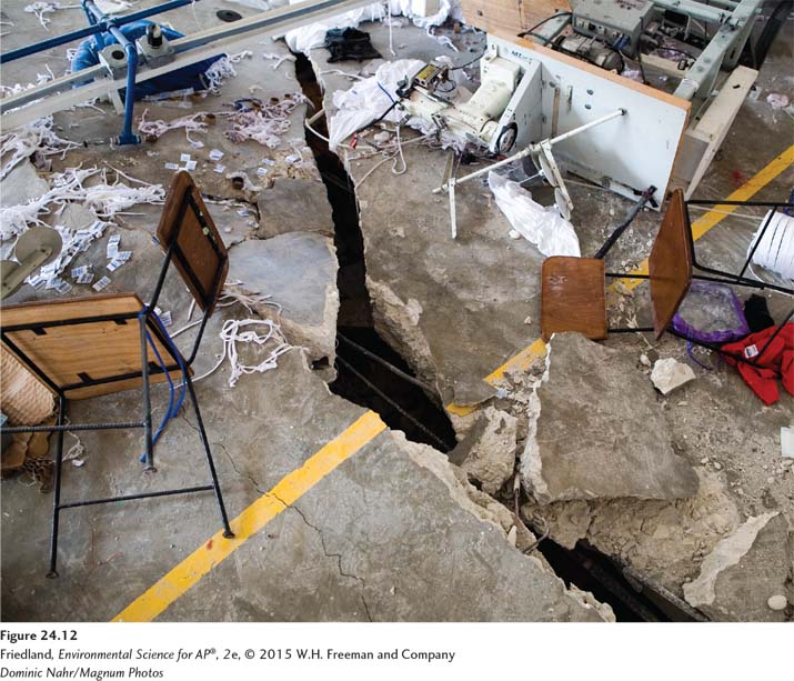
Even a moderate amount of Earth movement can be disastrous. Moderate earthquakes (defined as magnitudes 5.0 to 5.9) lead to collapsed structures and buildings, fires, contaminated water supplies, ruptured dams, and deaths. Loss of life is more often a result of the proximity of large population centers to the epicenter than of the magnitude of the earthquake itself. The quality of building construction in the affected area is also an important factor in the amount of damage that occurs. In 2008, a magnitude 7.9 earthquake in the southwestern region of Sichuan Province, China, killed more than 69,000 people. The epicenter was near a populated area where many buildings were probably not built to withstand a large earthquake. In 2010, a magnitude 7.0 earthquake in Haiti killed more than 200,000 people. Many of the victims were trapped under collapsed buildings (FIGURE 24.12).
Extra safety precautions are needed when dangerous materials are used in areas of seismic activity. Nuclear power plants are designed to withstand significant ground movement and are programmed to shut down if movement above a certain threshold occurs. The World Nuclear Association estimates that 20 percent of nuclear power plants operate in areas of significant seismic activity. Between 2004 and 2009, in four separate incidents, nuclear power plants in Japan shut down operation because of ground movement that exceeded the threshold. In 2011, seismic activity there led to a devastating major earthquake and tsunami that caused the second-
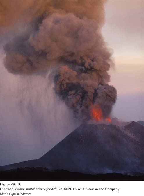
Volcanoes, when active, can be equally disruptive and harmful to human life. Active volcanoes are not distributed randomly over Earth’s surface; 85 percent of them occur along plate boundaries. As we have seen, volcanoes can also occur over hot spots. Depending on the type of volcano, an eruption may eject cinders, ash, dust, rock, or lava into the air (FIGURE 24.13). Volcanoes can result in loss of life, habitat destruction and alteration, reduction in air quality, and many other environmental consequences.
271
The world gained a new awareness of the impact of volcanoes when eruptions from a volcano in Iceland disrupted air travel to and from Europe in April 2010. Ash from the eruption entered the atmosphere in a large cloud and prevailing winds spread it over a wide area. The ash contained small particles of silicon dioxide, which have the potential to damage airplane engines. Air travel was suspended in many parts of Europe, and millions of travelers were stranded in what may have been the greatest travel disruption ever to have been caused by a volcano.
The rock cycle recycles scarce minerals and elements
Rock cycle The geologic cycle governing the constant formation, alteration, and destruction of rock material that results from tectonics, weathering, and erosion, among other processes.
The second part of the geologic cycle is the rock cycle, which refers to the constant formation and destruction of rock. The rock cycle is the slowest of all of Earth’s cycles. Environmental scientists are most often concerned with the part of the rock cycle that occurs at or near Earth’s surface.
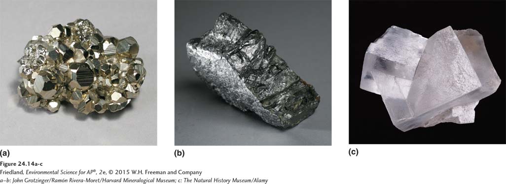
Rock, the substance of the lithosphere, is composed of one or more minerals (FIGURE 24.14). Minerals are solid chemical substances with uniform (often crystalline) structures that form under specific temperatures and pressures. They are usually compounds, but may be composed of a single element such as silver or gold.
Formation of Rocks and Minerals
FIGURE 24.15 shows the processes of the rock cycle. Rock forms when magma from Earth’s interior reaches the surface, cools, and hardens. Once at Earth’s surface, rock masses are broken up, moved, and deposited in new locations by processes such as weathering and erosion. New rock may be formed from the deposited material. Eventually, the rock is subducted into the mantle, where it melts and becomes magma again. The rock cycle slowly but continuously breaks down rock and forms new rock.
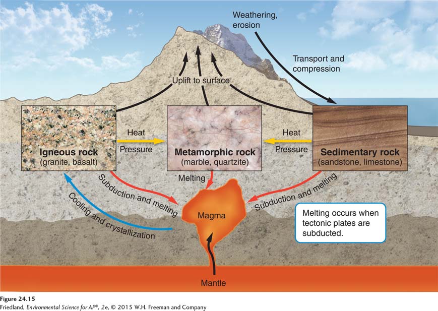
While magma is the original source of all rock, there are three major ways in which the rocks we see at Earth’s surface can form: directly from molten magma; by compression of sediments; and by exposure of rocks and other Earth materials to high temperatures and pressures. These three modes of formation lead to three distinct rock types: igneous, sedimentary, and metamorphic.
Igneous Rocks
Igneous rock Rock formed directly from magma.
Igneous rocks form directly from magma. They are classified by their chemical composition as basaltic or granitic, and by their mode of formation as intrusive or extrusive.
Basaltic rock is dark-
272
Intrusive igneous rock Igneous rock that forms when magma rises up and cools in a place underground.
Extrusive igneous rock Rock that forms when magma cools above the surface of Earth.
Intrusive igneous rocks form within Earth as magma rises up and cools in place underground. Extrusive igneous rocks form when magma cools above Earth’s surface, such as when it is ejected from a volcano or released by seafloor spreading. Extrusive rocks cool rapidly, so their minerals have little time to expand into large individual crystals. The result is fine-
Fracture In geology, a crack that occurs in rock as it cools.
The formation of igneous rock often brings to the surface rare elements and metals that humans find economically valuable, such as the lanthanum described at the beginning of this chapter. When rock cools, it is subject to stresses that cause it to break. Cracks that occur when rock cools, known as fractures, can occur in any kind of rock. Water from the surface of Earth running through fractures may dissolve valuable metals, which may precipitate out in the fractures to form concentrated deposits called veins. These deposits are important sources of gold-
Sedimentary Rocks
Sedimentary rock Rock that forms when sediments such as muds, sands, or gravels are compressed by overlying sediments.
Sedimentary rocks form when sediments such as muds, sands, or gravels are compressed by overlying sediments. Sedimentary rock formation occurs over long periods when environments such as sand dunes, mudflats, lake beds, or areas prone to landslides are buried and the overlying materials create pressure on the materials below. The resulting rocks may be uniform in composition, such as sandstones and mudstones that formed from ancient oceanic or lake environments. Alternatively, they may be highly heterogeneous, such as conglomerate rocks formed from mixed cobbles, gravels, and sands.
Sedimentary rocks hold the fossil record that provides a window into our past. When layers of sediment containing plant or animal remains are compressed over eons, those organic materials may be preserved, as described in Chapter 5.
273
Metamorphic Rocks
Metamorphic rock Rock that forms when sedimentary rock, igneous rock, or other metamorphic rock is subjected to high temperature and pressure.
Metamorphic rocks form when sedimentary rocks, igneous rocks, or other metamorphic rocks are subjected to high temperatures and pressures. The pressures that form metamorphic rock cause profound physical and chemical changes in the rock. These pressures can be exerted by overlying rock layers or by tectonic processes such as continental collisions, which cause extreme horizontal pressure and distortion. Metamorphic rocks include stones such as slate and marble as well as anthracite, a type of coal. Metamorphic rocks have long been important as building materials in human civilizations because they are structurally strong and visually attractive.