module 26 The Availability of Water
295
A very small amount of Earth’s aboveground water is found in the atmosphere and in the form of water bodies such as streams, rivers, wetlands, and lakes. In this module, we will examine the major sources of fresh water on Earth. We will also consider the effects of unusually high and low amounts of precipitation.
Learning Objectives
After reading this module you should be able to
describe the major sources of groundwater.
identify some of the largest sources of fresh surface water.
explain the effects of unusually high and low amounts of precipitation.
Groundwater can be extracted for human use
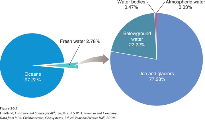
Nearly 70 percent of Earth’s surface is covered by water. As FIGURE 26.1 shows, this water is found in five main repositories, not including the water vapor and precipitation contained in the atmosphere. The vast majority of Earth’s water—
296
Aquifer A permeable layer of rock and sediment that contains groundwater.
Unconfined aquifer An aquifer made of porous rock covered by soil out of which water can easily flow.
Confined aquifer An aquifer surrounded by a layer of impermeable rock or clay that impedes water flow.
Water table The uppermost level at which the water in a given area fully saturates rock or soil.
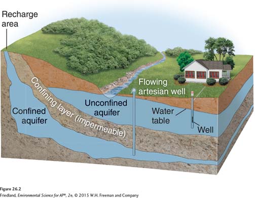
Groundwater exists in the multitude of small spaces found within permeable layers of rock and sediment called aquifers. FIGURE 26.2 shows how different types of aquifers are situated. Water can easily flow in and out of an unconfined aquifer, which is made of porous rock covered by soil. In contrast, confined aquifers are surrounded by a layer of impermeable rock or clay, which impedes water flow to or from the aquifer. The uppermost level at which the groundwater in a given area fully saturates the rock or soil is called the water table.
Groundwater recharge A process by which water percolates through the soil and works its way into an aquifer.
The process by which water from precipitation percolates through the soil and works its way into the groundwater is known as groundwater recharge. If water falls on land that contains a confined aquifer, however, it cannot penetrate the impermeable layer of rock. A confined aquifer can only be recharged if the impermeable layer of rock has a surface opening that can serve as a recharge area.
Spring A natural source of water formed when water from an aquifer percolates up to the ground surface.
Artesian well A well created by drilling a hole into a confined aquifer.

Aquifers serve as important sources of fresh water for many organisms. Plant roots can access the groundwater in an aquifer and draw down the water table. Water from some aquifers naturally percolates up to the ground surface as springs (FIGURE 26.3). Springs serve as a natural source of water for freshwater aquatic biomes, and they can be used directly by humans as sources of drinking water. Humans discovered centuries ago that water can also be obtained from aquifers by digging a well—
The age of water in aquifers varies, as does the rate at which aquifers are recharged. The water in an unconfined aquifer may originate from water that fell to the ground last year or even last week. This direct and rapid connection with the surface is one of the reasons water from unconfined aquifers is much more likely to be contaminated with chemicals released by human activities. Confined aquifers, on the other hand, are generally recharged very slowly, perhaps over 10,000 to 20,000 years. For this reason, water from a confined aquifer is usually much older and less likely to be contaminated by anthropogenic chemicals than is water from an unconfined aquifer.
297
Large-
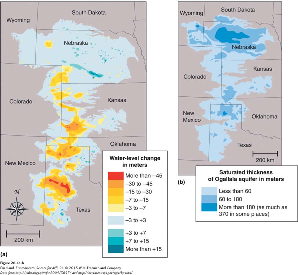
Cone of depression An area lacking groundwater due to rapid withdrawal by a well.
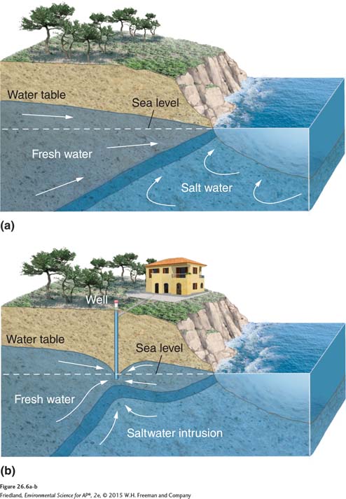
FIGURE 26.5 shows what happens when more water is withdrawn from an aquifer than enters the aquifer. As the water table drops farther from the ground surface, springs that once bubbled up to the surface no longer emerge, and spring-
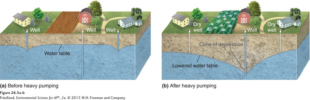
Saltwater intrusion An infiltration of salt water in an area where groundwater pressure has been reduced from extensive drilling of wells.
298
In some situations, water quality is compromised when fresh water is pumped out of wells faster than the aquifer can be recharged. FIGURE 26.6 shows how this can happen when wells are drilled near coastlines. Some coastal regions have an abundance of fresh water underground. This groundwater exerts downward pressure that prevents the adjacent ocean water from flowing into aquifers and mixing with the groundwater. As humans drill thousands of wells along these coastlines, however, rapid pumping draws down the water table, reduces the depth of the groundwater, and thereby lessens that pressure. The adjacent salt water is then able to infiltrate the area of rapid pumping, making the water in the wells salty. An infiltration of salt water in an area where groundwater pressure has been reduced from extensive drilling of wells is called saltwater intrusion and it is a common problem in coastal areas.
Surface water is the collection of aquatic biomes
Surface water is the fresh water that exists aboveground and includes streams, rivers, ponds, lakes, and wetlands. As mentioned in Chapter 4, these waters typically represent freshwater biomes that perform a number of important functions.
Floodplain The land adjacent to a river.
The world’s three largest rivers, as measured by the volume of water they carry, are the Amazon in South America, the Congo in Africa, and the Yangtze in China. Early human civilizations typically settled along major rivers not only because these waterways served as important means of transportation but also because the land surrounding rivers is often highly fertile. Most streams and rivers naturally overflow their banks during periods of spring snowmelt or heavy rainfall. This excess water spreads onto the land adjacent to the river, called the floodplain, where it deposits nutrient-
299
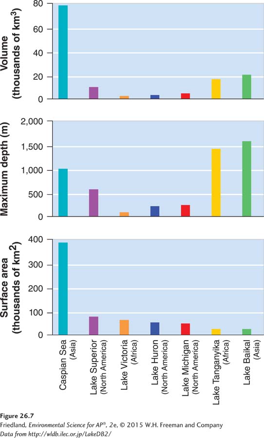
Ponds and lakes typically form in depressions in the landscape that are filled by precipitation, runoff that is not absorbed by the surrounding landscape, and groundwater that flows into the depression. As you can see in FIGURE 26.7, we can compare the size of Earth’s lakes according to surface area, depth, or volume. Some lakes, such as Lake Victoria in Africa, have a large surface area but are not especially deep. Other lakes, such as Lake Baikal in Asia, do not have a large surface area, but are extremely deep and therefore have a large volume.
Lakes can be created by a variety of processes, including tectonic activity and glaciation. When tectonic activity causes areas of land to rise up, it can isolate a region of the ocean. Because lakes formed in this way were once part of the ocean, they have higher salinities than other lakes. The Caspian Sea in western Asia is an excellent example of a salty lake that was formed by tectonic uplift. Tectonic activity can also cause land to split open into long, deep fissures that subsequently fill with water. Some of the world’s largest lakes have formed this way, including Lake Victoria and Lake Tanganyika in Africa and Lake Baikal in Asia. Another way that lakes are formed is through the movement of glaciers. Over thousands of years, glacial movement scrapes large depressions in the land that subsequently fill with water. This process is thought to have played a major role in the creation of the Great Lakes in North America.
As we saw in Chapter 4, freshwater wetlands play an important role in water distribution and regulation. During periods of heavy rainfall that might otherwise lead to flooding, these freshwater wetlands—
Wetlands are measured by surface area. There is some debate about which freshwater wetland is the world’s largest, but most researchers consider the Pantanal in South America to be the largest wetland and the Florida Everglades to be the second largest.
Atmospheric water produces precipitation
Although the atmosphere contains only a very small percentage of the water on Earth, that atmospheric water is essential to global water distribution. People living in arid regions rely heavily on precipitation, in the form of rain and snow, for their water needs. In certain regions, such as East Africa, annual rainfall follows a fairly regular pattern, with April, May, October, and November normally rainy months. However, even areas with predictable rainfall patterns can experience unexpected droughts. In the fall of 2000, the United Nations Food and Agriculture Organization reported that a succession of droughts had put 16 million people at risk of starvation in eastern Africa. In 2004, the worst drought in more than a decade adversely affected many parts of southern Africa, destroying crops, killing cattle, and causing millions of people to go hungry.
300
In addition to the direct losses of human lives, livestock, and crops that droughts cause, they also have long-
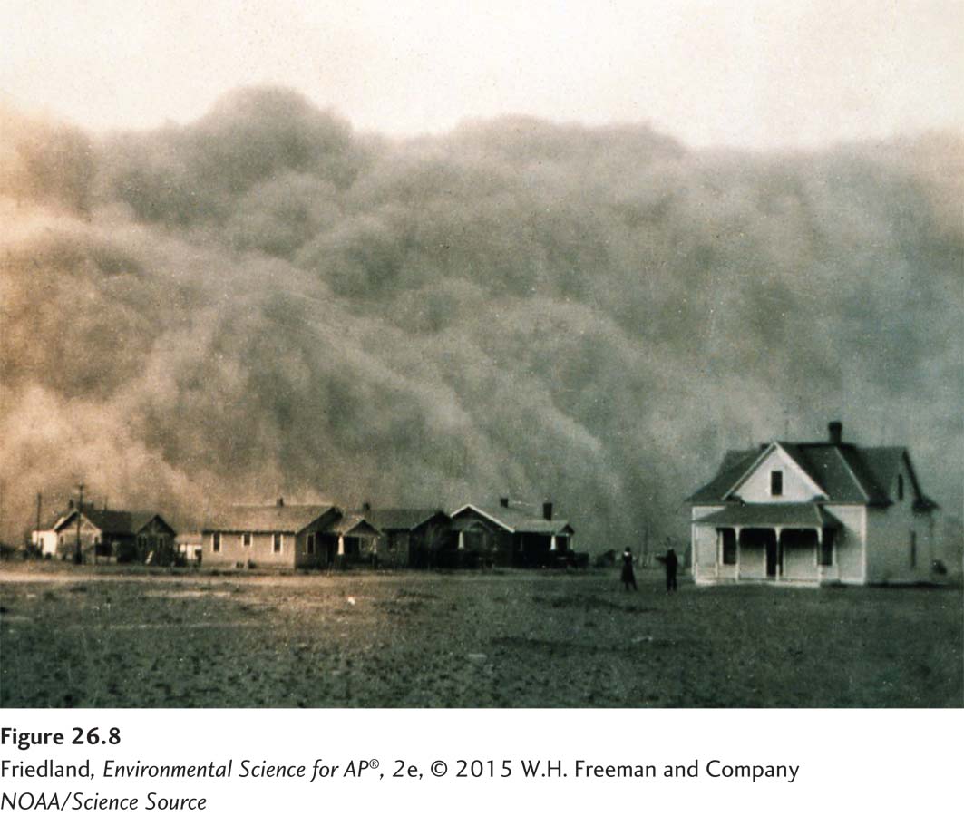
Human activities can contribute to the negative effects of droughts. In the midwestern United States in the 1920s and 1930s, for example, the amount of conversion from native grasslands to wheat fields increased dramatically. Because wheat fields are more susceptible to soil erosion by wind than are native grasslands, this conversion produced many more hectares of land susceptible to erosion. In the early 1930s, a severe and prolonged drought caused a decade of crop failures. With few crop plants remaining alive to hold the soil in place, the drought led to massive dust storms as winds picked up the parched topsoil and blew it away (FIGURE 26.8). Indeed, one dust storm, on April 14, 1935, was so severe that the Sun was entirely blocked out in the southern Great Plains, leading to the name “Black Sunday.” Topsoil from these dust storms traveled as far as Washington, D.C., and earned the southern Great Plains the nickname of “the Dust Bowl.” The decade of dust storms and the resulting losses of topsoil led to large-
Flooding occurs when water input exceeds the ability of an area to absorb that water. Many drought-
Impermeable surface Pavement or buildings that do not allow water penetration.
Human activities can also worsen the risk of flooding. In healthy natural areas, porous soil and wetlands soak up excess rainwater. However, in areas where the soil has been baked hard by drought, water that comes from heavy rainfalls cannot soak into the ground. This is also true in urban and suburban areas with large areas of impermeable surfaces—pavement or buildings that do not allow water to penetrate the soil. Instead, storm waters run off over impermeable soil or paved surfaces into storm sewers or nearby streams. Excess water that the ground does not absorb fills streams and rivers, which can overflow their banks and may flood lowland areas. Like droughts, floods can lead to crop and property damage as well as losses of animal and human lives.