module 27 Human Alteration of Water Availability
302
We have seen that the availability of water around the world can be unpredictable. In the Klamath River, for example, years of low precipitation caused an insufficient water supply for human needs. As a result, humans have learned to live with variations in water availability in several ways. We can channel the flow of flood waters with levees and dikes, block the flow of rivers with dams to store water, divert water from rivers and lakes and transport it to distant locations, and even obtain fresh water by removing the salt from salt water. In this module we will look at each of these water distribution methods and examine their costs and benefits.
Learning Objectives
After reading this module you should be able to
compare and contrast the roles of levees and dikes.
explain the benefits and costs of building dams.
explain the benefits and costs of building aqueducts.
describe the processes used to convert salt water into fresh water.
Levees and dikes are built to prevent flooding
Levee An enlarged bank built up on each side of a river.
Before the intervention of humans, most rivers periodically overflowed their banks. These occasional overflows of nutrient-
The use of levees has produced several major challenges. First, the fertility of these lands is reduced because natural floodwaters no longer add fertility to floodplains by depositing sediments there. Second, because the sediments do not leave the river, they are carried farther downstream and settle out where the river enters the ocean. Third, levees may prevent flooding at one location, but by doing so they force floodwater farther downstream where it can cause even worse flooding. Finally, the building of levees encourages development in floodplains, although these areas will still occasionally flood. This practice raises the question of whether development should be allowed in areas where flooding remains a high risk.
303
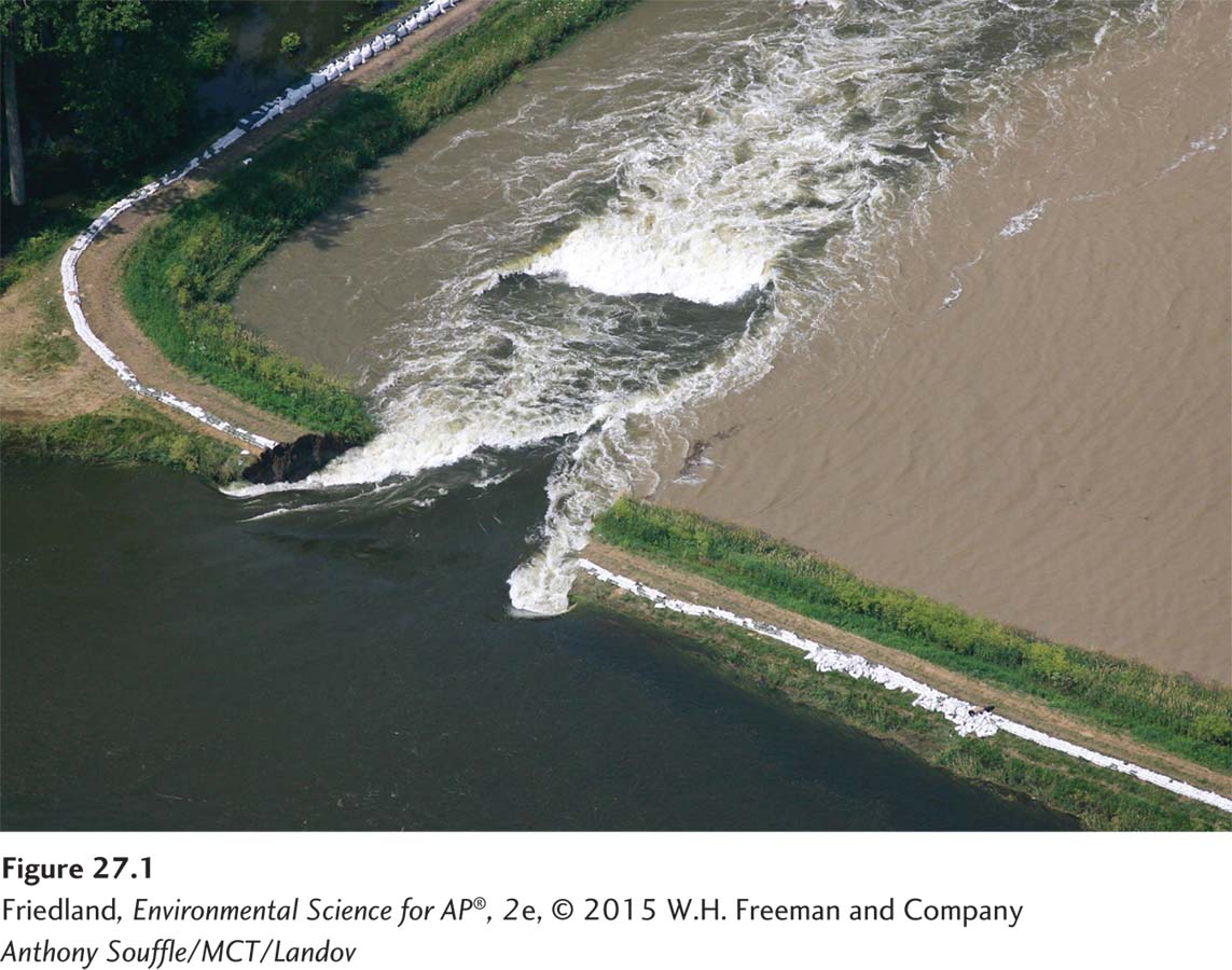
When floodwaters become too high, levees can either collapse due to the tremendous pressure of the water, or water can come over the top and quickly erode a large hole in the levee. Both events result in massive flooding (FIGURE 27.1). One of the most famous levee failures occurred in New Orleans in 2005 as the result of Hurricane Katrina. The levees could not contain the storm surge and heavy rainfall associated with the hurricane. The water overtopped nearly 50 levees, quickly washing out the banks of dirt and flooding many of the neighborhoods that the levees were built to protect. The hurricane and the devastating floodwaters caused into 1,800 deaths and over $80 billion in damage to homes and businesses.
Dike A structure built to prevent ocean waters from flooding adjacent land.
Dikes are enlarged banks built up to prevent ocean waters from flooding adjacent land. Functionally, dikes are similar to levees in that they are built to keep water from flooding onto the land. Dikes are common in northern Europe, where large areas of farmland lie below sea level. Perhaps the best known dikes are those of the Netherlands, where dikes have been used for nearly 2,000 years. Approximately 27 percent of the land in the Netherlands is below sea level. The dikes, combined with pumps that move any intruding water back out to the ocean, have allowed the country to inhabit and farm areas that would otherwise be under water. The original pumps were powered by windmills, which is why we often associate the Netherlands with wind energy. Today, however, the water is pumped with electric and diesel pumps.
Dams are built to restrict the flow of streams and rivers
Dam A barrier that runs across a river or stream to control the flow of water.
Reservoir The water body created by a damming a river or stream.
A dam is a barrier that runs across a river or stream to control the flow of water. The water body created by damming a river or stream is called a reservoir. Dams hold water for a wide variety of purposes, including human consumption, generation of electricity, flood control, and recreation. In 2013, there were 845,000 dams in the world and more than 84,000 dams in the United States. The largest reservoir system in the United States is along the Missouri River. With six dams and reservoirs in Montana, North Dakota, South Dakota, and Nebraska, this system stores nearly 90 trillion liters (24 trillion gallons) of water.
For centuries, humans have used dams to do work, from turning waterwheels that operated grain mills to powering modern turbines that generate electricity in hydroelectric plants. Although hydroelectric dams (discussed further in Chapter 13) are some of the largest dams in the world, they represent only 3 percent of all dams in the United States. In contrast, 18 percent of U.S. dams were built with the primary purpose of flood control—
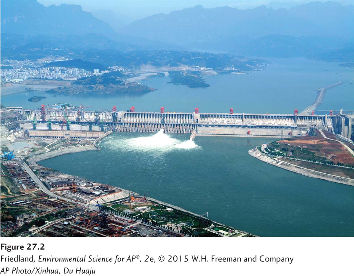
Dams provide substantial benefits to humans, but they come with financial, societal, and environmental costs. The world’s largest dam, the Three Gorges Dam built across the Yangtze River in China (FIGURE 27.2), illustrates these costs and benefits well. This massive structure is 2 km (1.3 miles) wide and 185 m (610 feet) high, and has created a reservoir 660 km (410 miles) long behind it. The Three Gorges Dam, completed in 2006, took 13 years to construct. The reservoir required another 2 years to fill with water.
The benefits of the Three Gorges Dam include the large amount of hydroelectric power it generates, which reduces the extraction and use of fossil fuels. In addition, the dam helps prevent the seasonal flooding that damaged downstream cities and villages and killed more than 1 million people over the past 100 years.
The costs of building dams, both to people and the environment, are substantial. Building a dam, like other large-
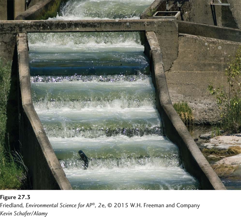
Fish ladder A stair-
304
One of the most common environmental problems associated with dams is the interruption of the natural flow of water to which many organisms are adapted. For migrating fish such as salmon, dams represent an insurmountable obstacle to breeding. The loss of these fish can have a cascading effect on other organisms that depend on them, such as bears that feed on migrating salmon. To alleviate this problem, fish ladders, which are built like a set of stairs with water flowing over them, have been added to some dams. Migrating fish can swim up the fish ladders and reach their traditional breeding grounds (FIGURE 27.3). Fish are also impacted when water is released from a dam to generate electricity. Passing millions of gallons of water through a spinning turbine kills millions of fish each year.
Using dams to prevent seasonal flooding has other consequences for the ecology of an area. Seasonal flooding represents a natural disturbance that scours out pools and shorelines, and this disturbance favors colonization by certain plants and animals. Some of the species that are highly dependent on such disturbances are very rare. In recent years, managers have begun to experiment with releasing large amounts of water from reservoirs to simulate seasonal flooding; the results have been very promising. In some areas, dams have been removed where they are no longer needed, as described at the opening of this chapter. In these cases, the natural flow of water has been restored and much of the natural ecology has been quickly restored.
Aqueducts carry water from one location to another
Aqueduct A canal or ditch used to carry water from one location to another.
While dams are designed to hold water back and store it, we often also need to move water from one place to another. Aqueducts are canals or ditches used to carry water from one location to another. Typically, aqueducts remove water from a lake or river to a place where it is needed. Although aqueducts are famously associated with the Roman Empire, their use dates back to at least the seventh century BCE in Greece. The earliest aqueducts were made of limestone, but modern aqueducts include concrete canals and pressurized steel pipes laid above or under the ground. These structures are more efficient water carriers than the ditches and stone-
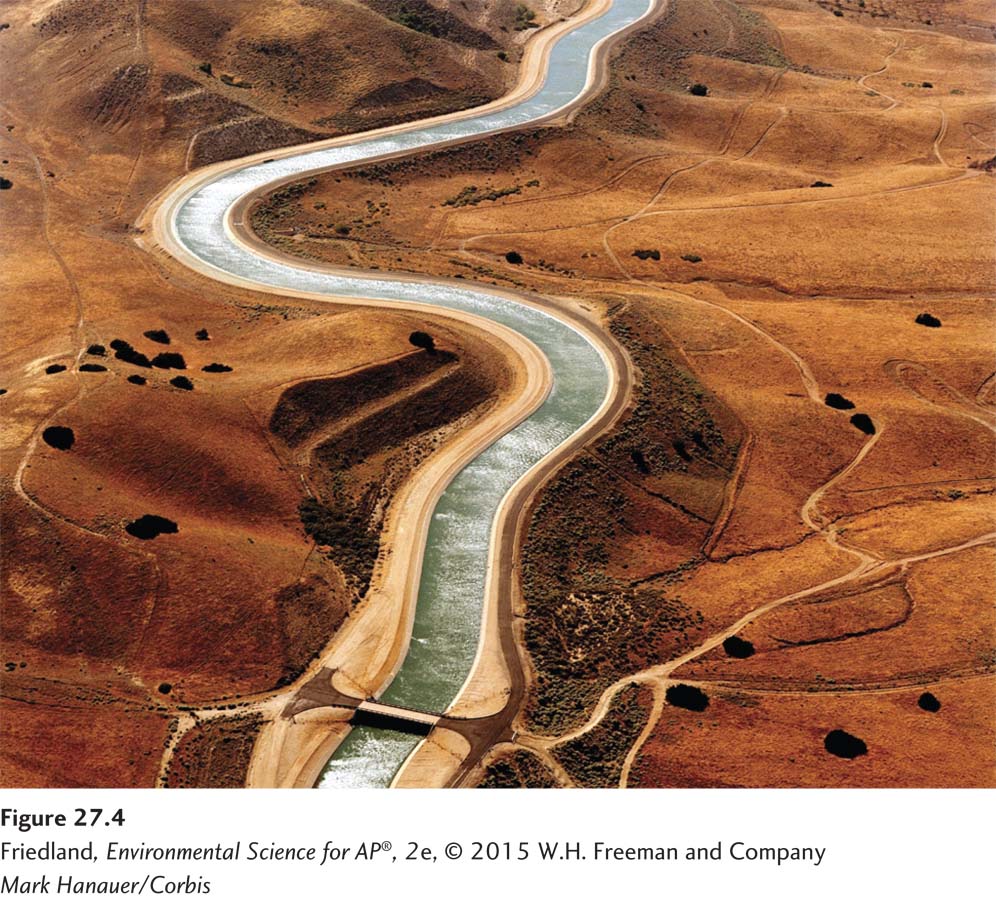
In the United States, two of the country’s largest cities, New York and Los Angeles, depend on aqueducts to meet their daily water needs. The Catskill Aqueduct brings clean, fresh water over 200 km (120 miles) from the streams and lakes of the Catskill Mountains to New York City. The Colorado River Aqueduct is a canal that carries water 400 km (250 miles) from the Colorado River to Los Angeles (FIGURE 27.4).
Using aqueducts to transport water supplies comes with costs and benefits. Although bringing water to cities from pristine areas may ensure its cleanliness, the construction of aqueducts is expensive and disturbs natural habitats. Aboveground aqueducts can fragment an environment. Even if an aqueduct is buried as an underground pipeline, a great deal of disruption occurs during construction. Often water is diverted from a natural river where it has flowed for millennia. Some major rivers in the United States, including the Colorado River and the Rio Grande, now lose so much water in multiple locations that during certain periods the rivers go dry before they reach the ocean.
305
Some water diversion projects have international impacts. India and Bangladesh, for example, share nearly 250 rivers that originate in the Himalayas of India and flow into Bangladesh. In 2009, India proposed a large-
At the same time that India is diverting water that would naturally flow into Bangladesh, neighboring China has begun the construction of dams on the Yarlung-
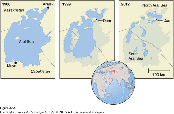
The most infamous river diversion project happened in the 1950s, when the Soviet Union diverted two rivers that fed the Aral Sea in Central Asia. Diversion of the rivers dramatically decreased freshwater input into the Aral Sea, increased the salinity of the remaining lake water, and destroyed the local fish populations. Although the Aral Sea was originally the fourth largest lake in the world in terms of surface area, the diversion project reduced its surface area by more than 60 percent, as shown in FIGURE 27.5. The withdrawals of water caused the Aral Sea to split into two parts: the North Aral Sea and the South Aral Sea. Dust storms have eroded soil, salt, and pesticide residues from the dry lake bed and carried particles of these substances into the atmosphere. The reduction in the size of the lake has also affected the local climate. Without the moderating effect of a large body of water on climate, summers in the region are now hotter and winters are colder. While efforts are being made to save the North Aral Sea, saving the South Aral Sea has been deemed too expensive and all efforts have been abandoned. The drying of the South Aral Sea continues today: The shallower eastern half of the South Aral Sea is predicted to be completely dry in 10 years.
Desalination converts salt water into fresh water
306
Desalination The process of removing the salt from salt water. Also known as Desalinization.
Today, some water-
Distillation A process of desalination in which water is boiled and the resulting steam is captured and condensed to yield pure water.
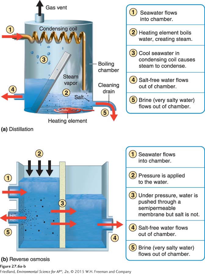
The two most common desalination technologies are distillation and reverse osmosis. Distillation (FIGURE 27.6a) is a process of desalination in which water is boiled and the resulting steam is captured and condensed to yield pure water. As the water is converted into steam, salt is left behind. A great deal of energy is required to boil the water and then condense it, so distillation can be a monetarily and environmentally expensive process.
Reverse osmosis A process of desalination in which water is forced through a thin semipermeable membrane at high pressure.
Reverse osmosis (FIGURE 27.6b) is a process of desalination in which water is forced through a thin semipermeable membrane at high pressure. Water can pass through the membrane, but salt cannot. Reverse osmosis is a newer technology that is more efficient and often less costly than distillation. However, the liquid that remains, called brine, has a very high salt concentration. It cannot be deposited on land because its high salt content would contaminate the soil, potentially harming plant and animal life. If dumped into a bay or coastal area, it can harm fish and other aquatic life. Typically, brine is returned to the open ocean, though its high salt concentrations can still cause harm to ocean life in areas where it is dumped.
Ultimately, all water management systems require a large investment to build, maintain, and repair. This means that many water-