3.3 Lifting Air: Atmospheric Stability
Describe the role of atmospheric instability in cloud formation.
As we saw in Section 1.3, the troposphere experiences strong vertical mixing. That mixing is a result of unstable air that moves higher in the atmosphere. Atmospheric instability is fundamental to many meteorological processes, and we will return to it later in this section.
Unstable air forms where warm air parcels rise on their own because they are less dense than the air surrounding them (see Figure 2.14). Hot-
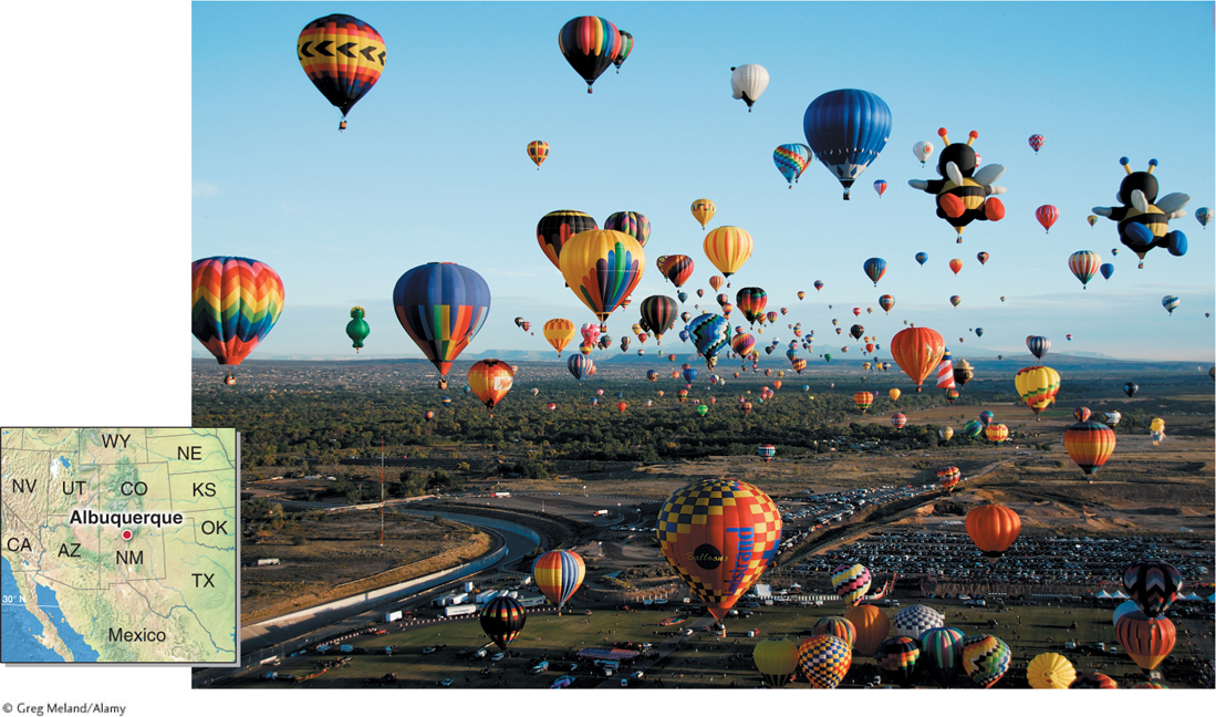
Figure 3.14
104
Rising Air is Cooling Air: The Adiabatic Process
While driving upward into the mountains, you may have noticed that sealed bags of chips or flexible plastic bottles expand at higher elevations (Figure 3.15). The same process that causes the air in these containers to expand acts on rising air parcels in the atmosphere.
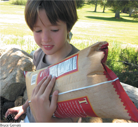
Figure 3.15
As air parcels rise, they expand, and as they expand, they cool. In the atmosphere, air pressure decreases with height (see Section 1.2). As an air parcel rises, the air pressure outside of it decreases, and the air molecules inside of it push the parcel outward, causing it to expand. This expansion uses energy, and as a result, the temperature inside the parcel decreases. Conversely, when an air parcel descends in the atmosphere, it is compressed into a smaller volume. When an air parcel is compressed, the air temperature within it increases.
Temperature changes within air parcels resulting from changes in their volume are called adiabatic temperature changes. Adiabatic cooling is the cooling of an air parcel through expansion. Adiabatic warming is the warming of an air parcel through compression.
adiabatic cooling
The cooling of an air parcel through expansion.
adiabatic warming
The warming of an air parcel through compression.
105
At what rate does the temperature of an air parcel change? The dry adiabatic rate is the rate of temperature change in an unsaturated parcel of air. The air temperature changes 10°C per 1,000 m (or 5.5°F per 1,000 ft) of change in altitude. That is, it will cool 10°C for every 1,000 m it rises, and it will warm 10°C for every 1,000 m it descends. Temperature changes at the dry adiabatic rate are illustrated in Figure 3.16.
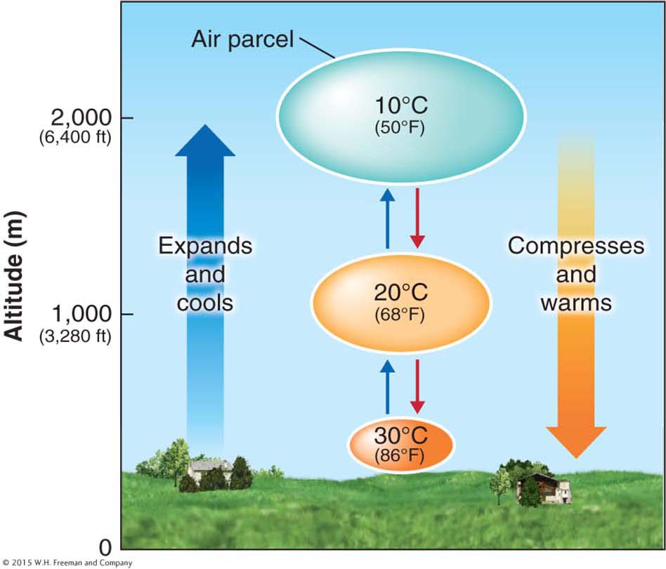
Figure 3.16
dry adiabatic rate
The rate of temperature change in an unsaturated parcel of air; 10°C/1,000 m (5.5°F/1,000 ft).
Recall that the environmental lapse rate, described in Section 1.3, refers to the decrease in air temperature outside the air parcel as altitude increases. The average environmental lapse rate is 6.5°C per 1,000 m (or 3.6°F per 1,000 ft), but this rate varies considerably for any given location at any given time.
Forming Clouds: The Lifting Condensation Level
Net condensation in the atmosphere is almost always caused by air that is lifted and cooled to its dew point. In Section 3.2, we learned that as air temperature drops, the relative humidity increases. It follows that if an air parcel rises and cools, its relative humidity will rise. If the parcel’s temperature decreases to the dew point, its relative humidity will become 100%. The air inside the parcel will become saturated, and cloud formation will follow. The altitude at which the temperature inside the air parcel reaches the dew point is called the lifting condensation level (LCL). Most clouds have flat bases because the LCL occurs at a constant altitude above Earth’s surface, as shown in Figure 3.17.
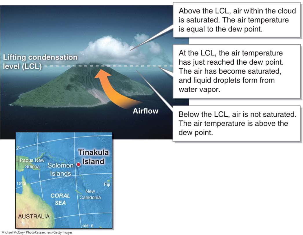
Figure 3.17
lifting condensation level (LCL)
The altitude at which an air parcel becomes saturated.
Above the LCL, water vapor condenses into liquid cloud droplets. In Section 3.2, we learned that whenever water undergoes a change in its state, heat is either absorbed from the surrounding environment (during evaporation) or released to the surrounding environment (during condensation). Above the LCL, condensation releases latent heat, which slows the rate of adiabatic cooling to the moist adiabatic rate. The moist adiabatic rate is the rate of cooling in a saturated air parcel. It is usually about 6°C per 1,000 m (3.3°F per 1,000 ft). The air parcel continues to cool as it lifts and expands above the LCL, but it cools less quickly due to the release of latent heat. The moist adiabatic rate is always less than the dry adiabatic rate. How much less depends on how much condensation is occurring within the cloud and, subsequently, how much latent heat is being released. Figure 3.18 illustrates this shift in adiabatic rates.
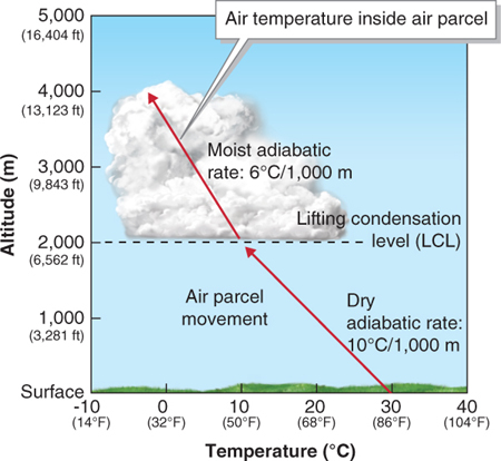
Figure 3.18
moist adiabatic rate
The rate of cooling in a saturated air parcel; usually about 6°C/1,000 m (3.3°F/1,000 ft).
106
Three Scenarios for Atmospheric Stability
In a stable atmosphere, the interior of air parcels is cooler and denser than the surrounding air. As a result, they will not rise unless forced to do so. A conditionally unstable atmosphere occurs where air parcels are stable while unsaturated near the ground and unstable when saturated higher up. In an unstable atmosphere air parcels are warmer and less dense than the surrounding air and rise on their own. These three stability scenarios are illustrated for three different air parcels in Figure 3.19.
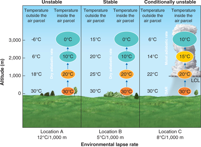
Figure 3.19
stable atmosphere
A condition in which air parcels are cooler and denser than the surrounding air and will not rise unless forced to do so.
unstable atmosphere
A condition in which air parcels rise on their own because they are warmer and less dense than the surrounding air.
In Figure 3.19, at location A, the air parcel cools at the dry adiabatic rate. The parcel is always warmer than the surrounding air and is therefore unstable. At location B, if the air parcel were to rise, it would always be cooler than the surrounding air and would be stable at all altitudes. Therefore, it will not rise higher unless it is somehow forced to do so (such as when moving over a mountain range).
 Animation
Atmospheric stability
http:/
At location C, the air parcel is cooler than the surrounding air below 1,000 m and is stable. At 1,000 m, it cools to its dew point of 20°C and becomes saturated. Above 1,000 m, it cools at a moist adiabatic rate of 6°C per 1,000 m. As a result, it becomes warmer than the surrounding air and unstable at 2,000 m. This air parcel is conditionally unstable. It became unstable only when condensation released latent heat that decreased its rate of adiabatic cooling.
Just as adiabatic cooling results as an air parcel expands, adiabatic warming follows when an air parcel is compressed. As moving air meets the windward side of a mountain range (the side facing the prevailing wind), it is forced upward and cools adiabatically. As it flows back down the leeward side of the mountain (the side sheltered from the prevailing wind), it warms adiabatically. Figure 3.20 illustrates this process.
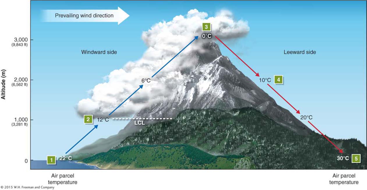
Figure 3.20
The leeward side of a mountain range is often warmer and drier than the windward side, because as air moves down the leeward side it compresses and warms. The leeward side of a mountain is often called a rain shadow due to the significantly reduced precipitation that falls there (see Figure 3.20). Arid regions can be found wherever tall mountains create a rain shadow. Hawai’i, for example, is seldom associated with aridity, but much of the island chain experiences rain-
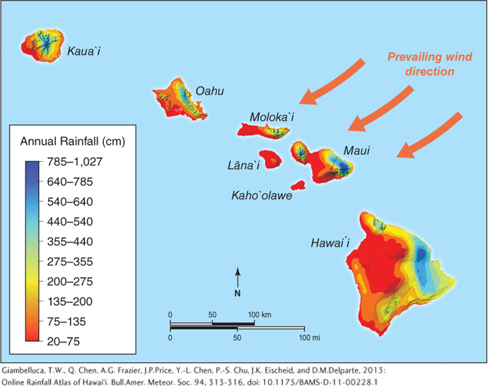
Figure 3.21
rain shadow
The dry, leeward side of a mountain range.
107
Four Ways to Lift Air and Form Clouds
As we have just seen, the lifting of air is fundamental to air saturation and cloud formation because rising air cools. There are four ways in which air can be lifted higher in the atmosphere and cooled: convective uplift, orographic uplift, frontal uplift, and convergent uplift (Figure 3.22).
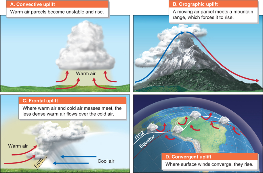
Figure 3.22
Convective Uplift
As we saw in Section 2.5, the Sun heats Earth’s surface unevenly, and Earth’s surface warms the atmosphere unevenly in turn. Warmed air forms unstable air parcels, which rise (see Figure 2.14). This process is called convective uplift.
convective uplift
The rising of an air parcel that is warmer and less dense than the surrounding air.
Orographic Uplift
Orographic uplift is the lifting of air over mountains (see Figure 3.20). Clouds formed by air moving up the windward side of mountains are called orographic clouds.
orographic uplift
The rising of air over mountains.
Frontal Uplift
In Earth’s atmosphere, geographically extensive and homogeneous regions of air called air masses (much larger than air parcels) form (see Section 5.1). Warm and cold air masses come into contact at midlatitudes, forming a transition zone, or front, between cold polar air and warm subtropical air. When warm and cold air masses meet, they do not mix. Instead, warm air flows over cold air because it is less dense and more buoyant. This process is called frontal uplift.
frontal uplift
The rising of warm air masses where they meet relatively cold air masses.
108
Convergent Uplift
The fourth mechanism that causes air to rise operates where surface winds converge in a geographic region of low atmospheric pressure. Convergent uplift is the process by which air rises as a result of converging airflow.
convergent uplift
The rising of air as a result of converging airflow.
The most geographically widespread area of convergent uplift occurs in the tropics, where prevailing winds converge from the north and south in a region called the ITCZ (or intertropical convergence zone). The ITCZ forms a band of low pressure that completely encircles Earth, in which thunderstorms are frequent. Along the ITCZ, converging and rising air strengthens convective uplift and thunderstorms. Therefore, in the tropics, convective and convergent uplift blend together into a single process. The ITCZ is explored further in Section 4.3.