12.5 The Tibetan Plateau, Climate, and People

Assess the relationship between food security in South Asia and the changing climate of the Tibetan Plateau.
The Tibetan Plateau and the Himalayas (Sanskrit for “abode of the snow”) are often referred to as the roof the world. This region is a dramatic example of the effects of continental collision. The area has many geophysical superlatives:
The average elevation of the plateau is about 4,500 m (14,800 ft), the highest on Earth.
No other mountain range is rising as quickly as the Himalayas. The western portions are rising up to 10 mm (0.39 in) per year. (This is the net rate of uplift, after erosion.)
The region contains the largest volume of ice outside the polar regions.
The plateau and surrounding mountains cover some 2.9 million km2 (1.1 million mi2), or almost half the area of the continental United States.
About 20% of the world’s population (1.4 billion people) receive freshwater from the region. It is the source of seven of Earth’s largest rivers.
Tectonically Driven Climate Change
Beginning about 55 million years ago, in the early Cenozoic era, a long global cooling trend began (see Section 6.2). This cooling trend coincided with the beginning of the collision between the Indian landmass and the Eurasian plate and the resulting uplift of the Tibetan Plateau and surrounding mountains..
The prevailing theory is that the uplift of the Tibetan Plateau was mainly responsible for the Cenozoic cooling trend. This uplift may have caused global cooling in three main ways:
Blocking airflow: The plateau and its mountains changed atmospheric circulation in the Northern Hemisphere. The uplifted region was so high that it diverted the westerlies and cold polar air masses farther south than they would otherwise go, as Figure 12.34 shows.
Changing atmospheric chemistry: As the Tibetan Plateau rose, weathering and erosion of the uplifting mountain ranges transferred carbon from the atmosphere to long-
term storage in seafloor sediments (see Section 6.3). Carbon dioxide levels dropped from about 1,000 ppm (parts per million) to the recent preindustrial levels of 300 ppm and lower. This reduction of atmospheric CO2 is thought to have been the main factor behind the long, slow Cenozoic cooling trend. Reflecting sunlight: As the plateau was lifted to higher and colder elevations, its vegetation cover was reduced to alpine tundra (see Section 8.4) or bare ground, exposing lighter-
colored rocks. In addition, it became covered in snow for much of the year, and permanent glaciers developed in the Himalayas. Bare rock, snow, and ice have high albedos. They reflect sunlight energy back out to space, rather than allowing it to warm the ground surface. Because the uplifted region was so geographically extensive, it reflected significant amounts of solar energy, resulting in cooling of the global atmosphere.
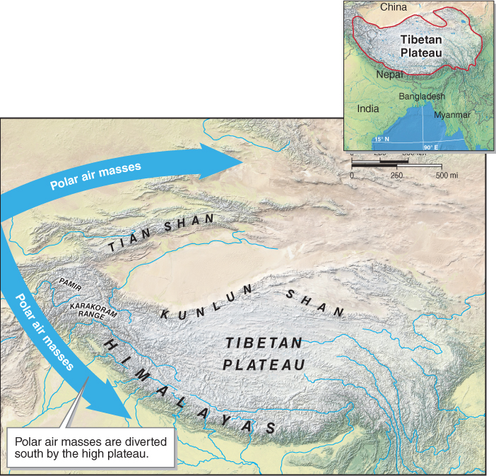
Figure 12.34
410
Anthropogenic Climate Change
As long as the plateau is being weathered, it will continue to pull carbon dioxide out of the atmosphere (see Section 6.3). But this transfer of carbon is a very slow process.
Over the last 150 years, people have been burning fossil fuels and releasing CO2 to the atmosphere much faster than natural processes such as weathering (and the ocean waters and plants) can remove it from the atmosphere. Thus, fossil fuel combustion has resulted in a net increase of CO2 in the atmosphere. Today, CO2 concentrations are about 400 ppm and rising (see Section 6.4).
As atmospheric CO2 concentrations increase, the atmosphere gets warmer. As the atmosphere gets warmer, mountain glaciers retreat upslope, where it is cooler. A 2012 study published in Nature examined over 7,000 glaciers in the Tibetan Plateau region. The researchers concluded that the glaciers of the Himalayas lost about 12 billion tons of ice per year between 2003 and 2008. Now, rather than the plateau driving climate change, climate change is changing the plateau and the surrounding mountain ranges. Anthropogenic climate change is reversing the 55-
Glaciers and Food Security
There is a direct relationship between the glaciers of the Tibetan Plateau region and the food security of the human population. About 1.4 billion people, approximately one-
Asia’s large rivers are fed by summer monsoon rainfall (see Section 4.4) and by seasonal melting of snow and glaciers in the mountains. The eight major rivers that originate on the Tibetan Plateau are the Indus, Ganges, Brahmaputra/Yarlung Tsangpo, Irrawady, Salween, Mekong, Yangtze, and Yellow (Figure 12.35). The Yangtze River is the longest river in Asia, at 6,300 km (3,915 mi), and the third longest river in the world. It flows through heavily populated areas of China, where it supports several hundred million people.
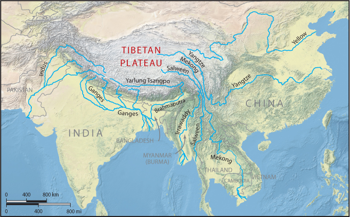
Figure 12.35
These rivers provide water for all aspects of human life, including household needs, fishing, navigation, hydroelectric power generation, and agriculture. The rivers are also tied to the global economy. For example, the water from these rivers supports about 75% of the world’s rice exports.
Many scientists see South Asia as particularly vulnerable to climate change in the coming decades, given the connection between glaciers, rivers, and people in the region. In the short term, further loss of the Tibetan Plateau’s glaciers could increase water supplies for South Asia as the ice melts. The long-
411