14.2 Pele’s Power: Volcanic Hazards
Explain the hazards volcanoes pose and which geographic areas are most at risk.
In Hawaiian myth, Pele is the volcano goddess. She is said to reside in the summit caldera of Kilauea on the island of Hawai’i. Pele embodies the many facets of volcanoes, ranging from life-
Two Kinds of Eruptions: Effusive and Explosive
effusive eruption
A nonexplosive eruption that produces mostly lava.
Shield volcanoes, such as those found on Hawai’i, present little threat to human life. Shield volcanoes have nonexplosive effusive eruptions that emit more lava than gases. Mafic lava from shield volcanoes usually flows slowly downhill and can be avoided.
Stratovolcanoes, on the other hand, are potentially serious geohazards. Their eruptions are called explosive eruptions. An explosive eruption is violent and yields large amounts of pyroclasts. Stratovolcanoes may produce effusive outpourings of mafic lava like shield volcanoes, but they are also capable of exploding violently with little warning.
Explosive eruptions send rock, ash, and volcanic gases high into the troposphere, or even into the stratosphere. In the troposphere, rain washes the volcanic material out in a few days or weeks. There is no rainfall in the stratosphere, however, so once ash and sulfur gases enter the stratosphere, they can remain suspended there for five years or more. These materials can encircle the globe and cause climate cooling for a few years (see Section 6.2).
453
Large explosive eruptions result when gas-
Question 14.4
Why do some volcanoes explode violently?
Volcanoes explode violently when gas in magma expands rapidly as the magma migrates upward toward the crust and experiences less pressure.
Island volcanoes can become particularly explosive when seawater migrates into the magma chamber, as might occur after an earthquake. As water comes into contact with the intense heat, it turns to vapor and expands rapidly and explosively. Figure 14.13 shows an explosive volcanic eruption in which the force of the expanding gases and collapsing magma chamber sent ash billowing high into the atmosphere.
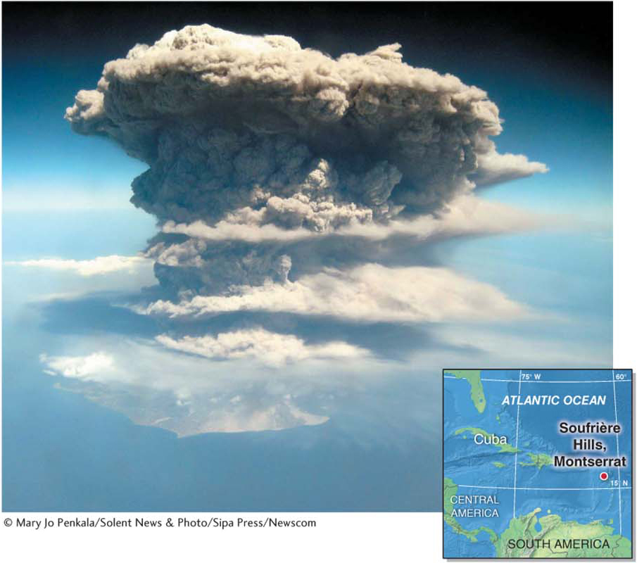
Figure 14.13
Ranking Volcanic Eruption Strength
volcanic explosivity index (VEI)
An index used to rank volcanic eruptions based on the amount of material a volcano ejects during an eruption.
The volcanic explosivity index (VEI) ranks volcanic eruption magnitude based on the amount of material a volcano ejects during an eruption. A VEI 5 eruption emits more than 1 km3 (0.24 mi3) of pyroclastic material into the atmosphere, and a VEI 6 eruption emits more than 10 km3 (2.4 mi3). During the last 10,000 years, there have been about 50 VEI 6 eruptions. The eruption of Tambora,  described in Geographic Perspectives, was the only VEI 7 eruption in historic times. Figure 14.14 compares large historical eruptions to the colossal prehistoric eruption of the Yellowstone caldera, 640,000 years ago.
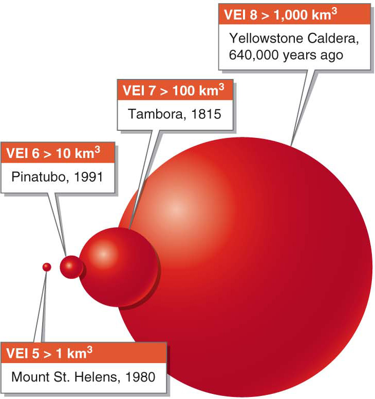
Figure 14.14
The Two Greatest Threats: Lahars and Pyroclastic Flows
Stratovolcanoes are among the most dangerous geohazards on the planet. Lava flows from these volcanoes are not their biggest threat because their lava usually flows slowly, so people can escape. The two greatest volcanic hazards are lahars and pyroclastic flows. Together, they account for about half of the volcano-
Torrents of Mud: Lahars
lahar
A thick slurry of mud, ash, water, and other debris that flows rapidly down a snow-
A lahar (a Javanese word that means “mudflow” or “debris flow”) is a mudflow that results when a snow-
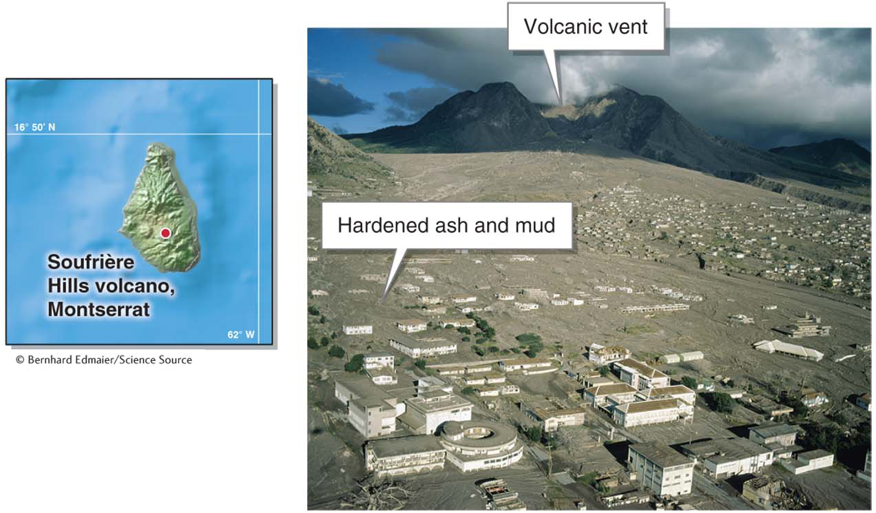
Figure 14.15
454
Blazing Clouds: Pyroclastic Flows
pyroclastic flow
(or nuée ardente) A rapidly moving avalanche of searing hot gas and ash.
Pyroclastic flows (also called nuées ardentes, meaning “blazing clouds”) are rapidly moving avalanches of gas and ash. Pyroclastic flows are one of the greatest volcanic hazards because they can travel at speeds up to 700 km/h (450 mph) and they can be as hot as 500°C (930°F). At night, these avalanches can glow orange from their intense heat. The largest flows can travel hundreds of kilometers from the volcanic vent. Figure 14.16 shows a pyroclastic flow on Mount Merapi in Indonesia.
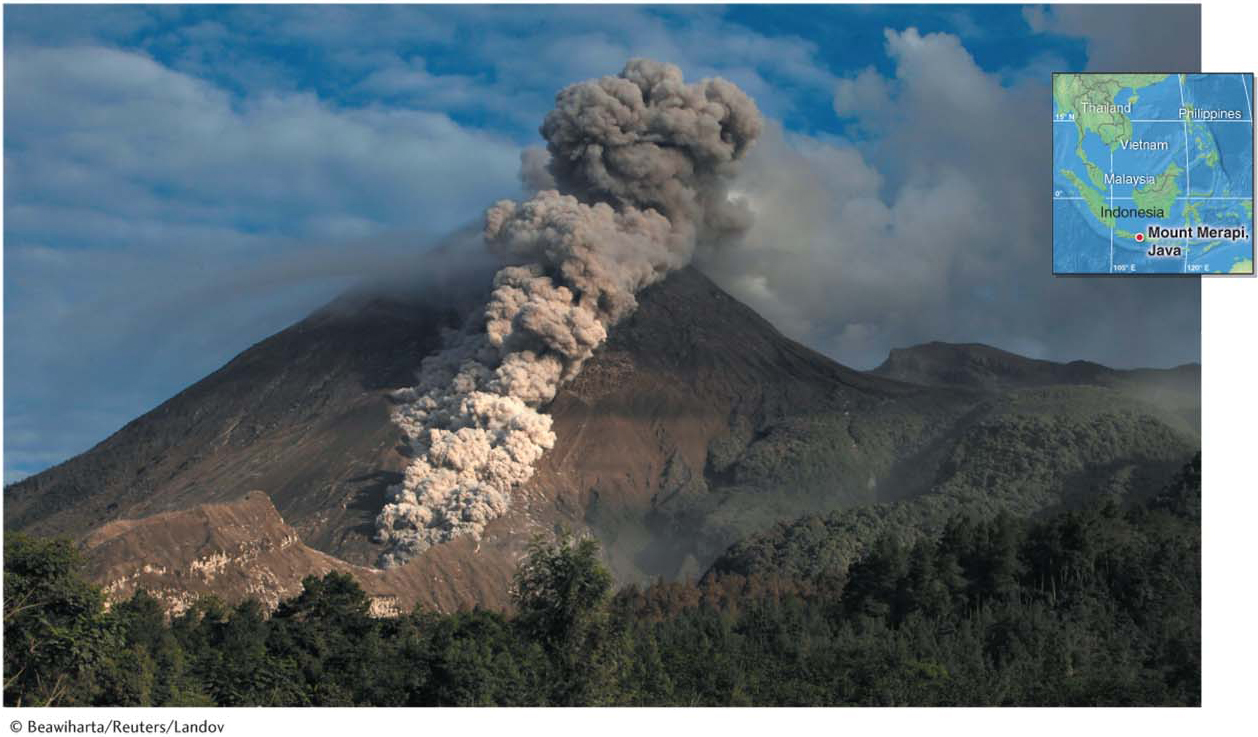
Figure 14.16
Lahars and pyroclastic flows are by far the most significant geohazards volcanoes present, but they are not the only ones. Volcanoes can also produce large earthquakes, dangerous lava flows, and smothering ashfalls. Picture This explores an unusual and unfortunate volcanic event that happened in Italy many centuries ago.
455
Picture This
The Pompeii Disaster
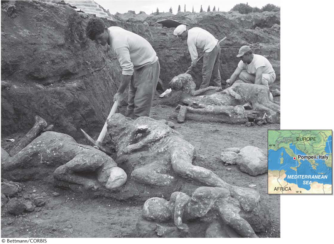
In 79 CE, on the morning of August 24, a series of earthquakes shook the region near the Italian city of Pompeii. At about 1:00 p.m., a menacing black ash cloud billowed up 25 km (15 mi) and shrouded Pompeii (and the nearby city of Herculaneum) in blackness. Eruptions continued for a week. As many as 16,000 people may have died, crushed under the weight of ash as rooftops collapsed or asphyxiated as they were buried alive. The town was entombed beneath 6 m (18 ft) of ash.
In 1749, mysterious terra cotta roof tiles were found beneath farm fields where a canal was being dug, hinting at a lost city beneath. It was not until the late 1880s that archaeologists began to excavate the ash to reveal the ruins of Pompeii beneath. As they were digging, they found many mysterious cavities in the ash. When these cavities were injected with plaster, shapes of people were revealed.
Mount Vesuvius, which was responsible for the destruction of Pompeii, is still alive and active. It last erupted for a period of 31 years, from 1913 to 1944. Since then, it has been silent. Fully aware of the risk posed by the volcano, the Italian government has offered up to 30,000 euros (US$40,000) to each of the 500,000 people living in the “red zone” of the volcano (the area of greatest hazard) to move farther away. Most have declined this offer.
Consider This
Question 14.5
H2Ga/xm2LPyZ4MciR6tSFvGmoq2UcSVK3fBhluyakhdIpVVjk9Rl1/1z0u6VPg7WskiES24ISjxxUvzictkYiKGQiFxaOThdoOhKIhkh00M9PsgoDtvm6ZLr9z3ocGM0C1t6VT+qoqlLMpUuDfMjtP7hRuupngg02xpK0OQRtyzTJzzmnRoGTeDCQsm3vzyqOG9dlRnZLUw=Question 14.6
gZtvcVlqX+FU1jH+qFnsDEZ0+MG4lvojiOtJDsSiV9KjTyDYsMhd7Uc1iIC6RuTCCwpr//ux7Czz0z1BACWEx3eb2n/Bw18FF/y0EuLIbyNuxhOSgbOAQgLoQsiOVRQVMFBtHxH/qc63YGDGq0Sa+g==
456
Can Scientists Predict Volcanic Eruptions?
Because volcanoes can be such a serious geohazard, predicting their eruptions would save many lives. Scientists can sometimes predict an eruption within weeks or months if a volcano gives warning signs. The monitoring of Mount St. Helens, in Washington State, is a good example of the process of monitoring warning signs and successfully anticipating an eruption, as illustrated in Figure 14.17.
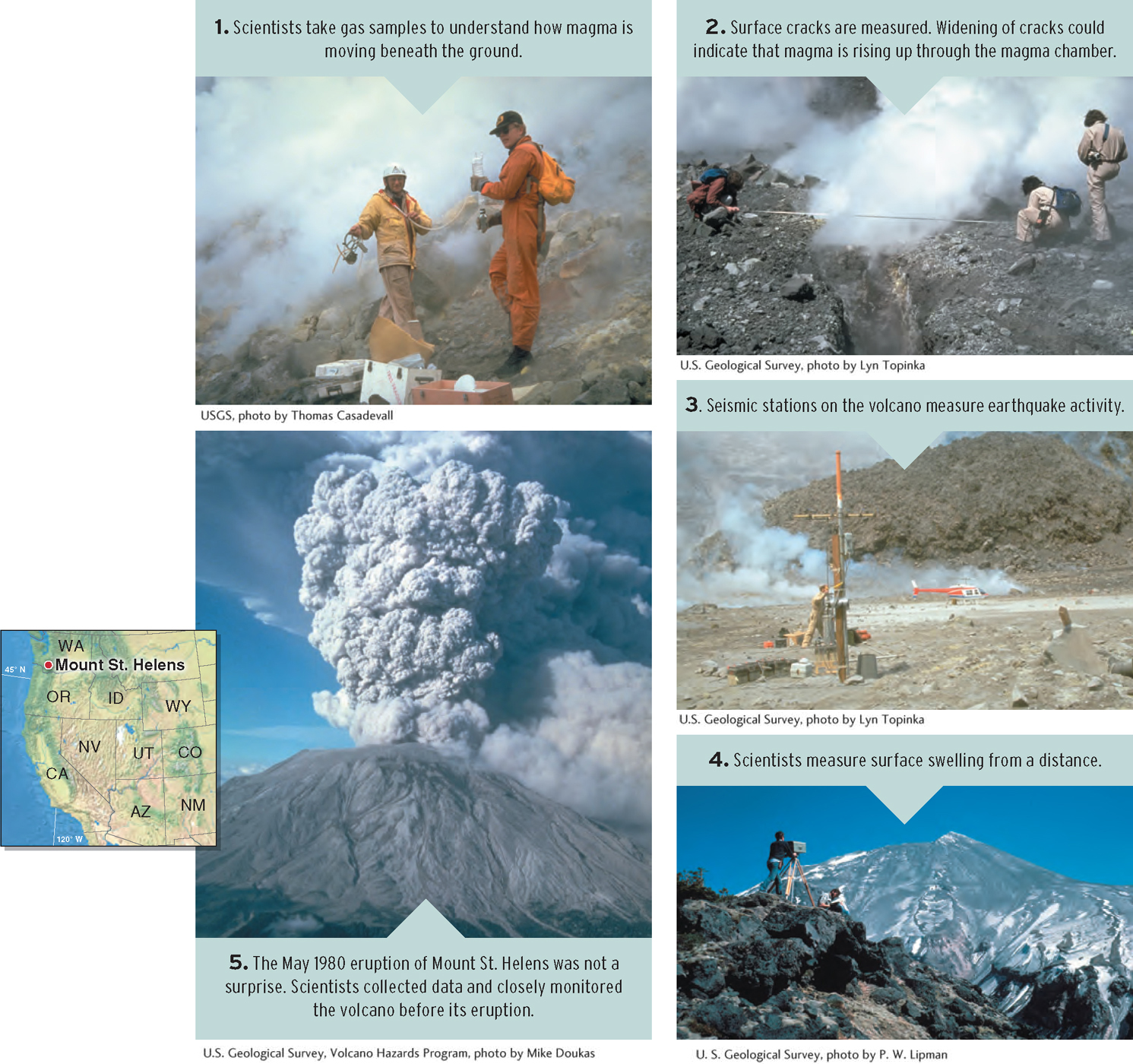
Figure 14.17
457
The Pacific Ring of Fire
Plate tectonic theory provides the framework to understand why volcanic landforms occur where they do. All volcanoes are found where the mantle is melted into magma, namely, at or near mid-
More than 60% of the Pacific Ocean’s margins, totaling some 40,000 km (25,000 mi), are subduction zones with active and dangerous stratovolcanoes. These volcanoes make up the Pacific Ring of Fire (see Section 12.3). Although shield volcanoes are found in the Pacific Ring of Fire, explosive stratovolcanoes are the most common type of volcano there. Many of them are dormant, but there are also many active and dangerous stratovolcanoes. Figure 14.18 provides an eruption history for some of the more active stratovolcanoes in the Pacific Ring of Fire.
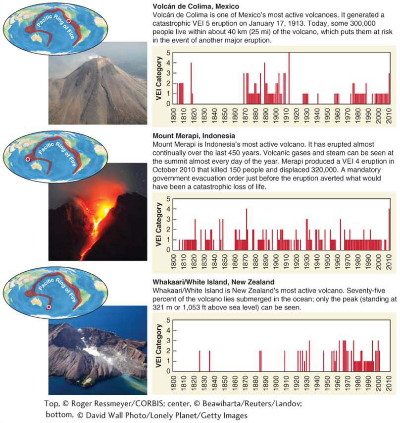
Figure 14.18
458