14.3 Tectonic Hazards: Faults and Earthquakes
Explain what causes earthquakes.
On Friday, March 11, 2011, seismographs around the world began detecting one of the largest earthquakes in recorded history, now called the 2011 Toãhoku earthquake. The shaking began at 2:46 p.m. local time. The earthquake was calculated at magnitude 9.0, a colossal event. There are more than 1 million detectable earthquakes on the planet each year, and this single 9.0 event released more energy than all of the others combined. Only four other recorded earthquakes have been larger. The earthquake focus was 32 km (20 mi) deep and 128 km (80 mi) from Sendai, on the island of Honshu, Japan. The aftershocks that followed for weeks were as powerful as magnitude 7.2.
The damage caused by the earthquake and its aftershocks was made much worse by a tsunami that reduced the low-
Faulting and Earthquakes
Although usually less noticeable than volcanic hazards, earthquakes are as dangerous as volcanoes, or even more so. The 2011 Toãhoku earthquake, like all earthquakes, occurred when Earth’s crust broke along a geologic fault, which is a fracture in the crust where movement and earthquakes occur (see Section 12.4).
Most earthquakes are too small to be felt by people. Only seismographs can detect them. Many of those that do shake the ground strongly occur in remote areas, such as the deep seafloor, and are harmless to people. Very rarely, a massive earthquake, such as the Toãhoku earthquake, occurs near a populated region, causing catastrophic loss of life and structural damage to the built environment.
459
Three Types of Faults
normal fault
The result of tensional force as two fault blocks move apart, causing one fault block to slip downward in relation to the other fault block.
reverse fault
The result of compressional force as two fault blocks are pushed together, causing one block to move upward in relation to another block.
strike-slip fault
The result of shearing force as one block moves horizontally in relation to another block.
There are three basic types of faults: normal faults, reverse faults, and strike-
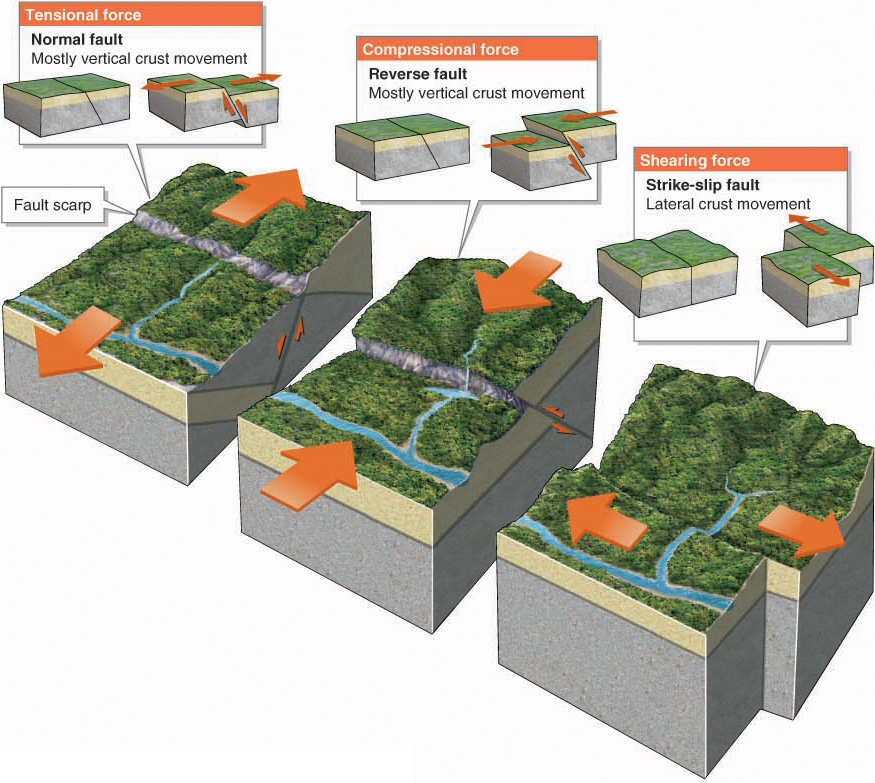
Figure 14.19
fault scarp
A cliff face resulting from the vertical movement of a reverse or normal fault.
Reverse and normal faults create a fault scarp, or cliff face, that results from the vertical movement of the fault blocks. Strike-
Figure 14.20
Fault scarps indicate that a normal or reverse fault is at work, and offset features indicate that a strike-
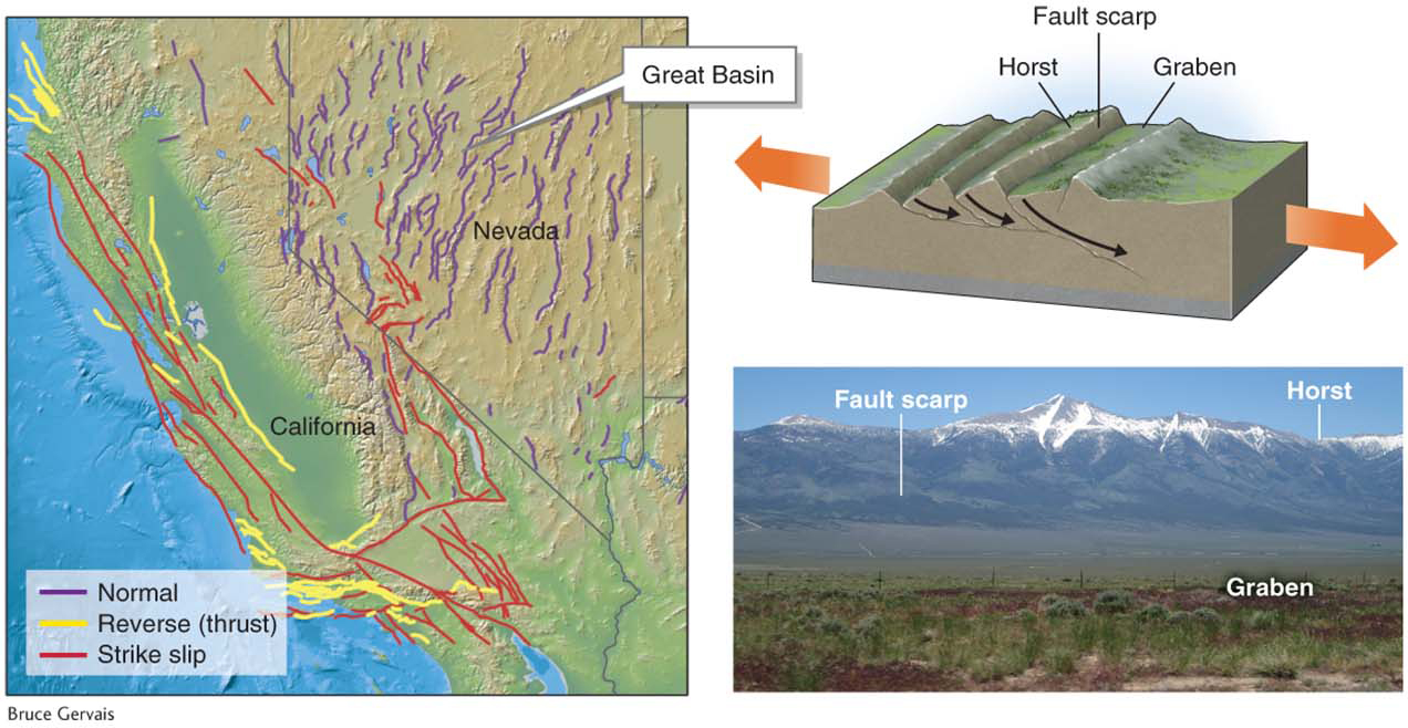
Figure 14.21
460
How Do Faults Generate Earthquakes?
focus
The location of initial movement along a fault during an earthquake.
epicenter
The location on the ground’s surface immediately above the focus of an earthquake, where earthquake intensity is usually greatest.
When subjected to geologic stresses, fault blocks usually do not move smoothly past one another. Instead, friction between them causes them to stick together, and stress energy builds up in the crust. Eventually, the geologic stress exceeds the friction, the crust breaks (either along a preexisting fault or along a new fault), and the blocks move. As each block moves, the built-
Question 14.7
What causes earthquakes?
When crust under stress suddenly breaks and moves, ripples of energy travel outward and shake the ground.
Elastic-
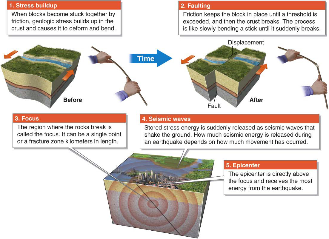
Figure 14.22
 Animation
Earthquake generation
http:/
What Are Foreshocks and Aftershocks?
Small foreshock earthquakes sometimes precede large earthquakes. Foreshocks may be caused by smaller cracks developing as the deformed and stressed crust is about to fail. Going back to the bending stick analogy used in Figure 14.22, as the stick bends, small splinters of wood may form—
aftershock
A small earthquake that follows the main earthquake.
Very commonly, especially with large earthquake events, smaller earthquakes called aftershocks follow the main shock. Aftershocks occur because the blocks are settling into their new positions after they have been moved. Most aftershocks are much smaller than the main earthquake and occur on the same fault as the initial earthquake. Occasionally, aftershocks occur on different faults nearby.
Geographic Patterns of Earthquakes
Most earthquakes occur along plate boundaries in seismic belts. Plate boundaries give rise to earthquakes because of the interactions between moving plates that occur there. Figure 14.23 explains some major characteristics of earthquakes at different types of plate boundaries.
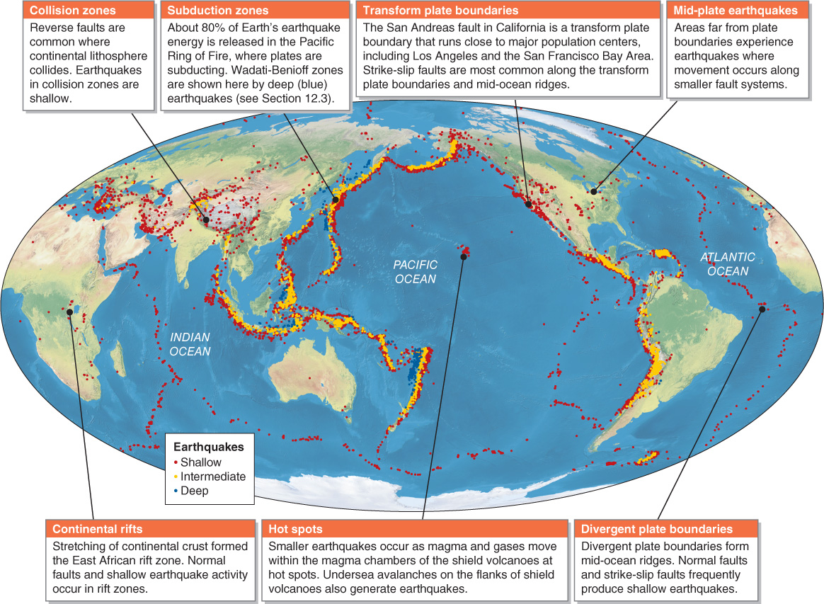
Figure 14.23
461