15.2 Dissolving Rocks: Karst Landforms
Describe different kinds of karst landforms and explain how each forms.
In 1864, when Jules Verne’s book Journey to the Center of the Earth was published, its readers were transported to enormous subterranean caverns lighted by bioluminescent bacteria living on the caverns’ ceilings and filled with a deep subterranean ocean, on the shores of which were found giant mushrooms, petrified forests, and even living dinosaurs. Although these phenomena are not real, Verne’s imagination no doubt was inspired at least in part by subterranean karst caverns.
Karst refers to an area dominated by the weathering of carbonate rocks, usually limestone. The term karst is the German form of the Slovenian term kras, which means “barren landscape.” Groundwater plays a particularly important role in weathering limestone rocks and creating unusual surface landforms as well as subterranean cavern systems.
karst
An area dominated by the weathering of carbonate rocks, usually limestone.
Karst Processes
Why do carbonate rocks dissolve in rainwater? As rain falls through the atmosphere, it absorbs a small amount of carbon dioxide from the air. Water also absorbs carbon dioxide as it flows through soil that is rich in organic substances. Once water has absorbed carbon dioxide, it forms carbonic acid. Through the process of carbonation, acidic water reacts with the calcite in limestone, causing dissolution, the process in which minerals are dissolved in water and carried away. The rock is dissolved most where it is weakest; namely, along joints in the rock (see Section 15.1).
In some cases, acids other than carbonic acid dissolve carbonate rocks. In the unusual case of Carlsbad Caverns and Lechuguilla Cave in New Mexico, for example, sulfuric acid that forms from natural oil deposits is dissolving the limestone bedrock.
Areas with limestone bedrock form the most widespread type of karst topography. All carbonate rocks, including marble, dolomite, gypsum, and chalk, are, however, subject to dissolution. Karst topography forms fastest in warm tropical regions. Although some Arctic regions have carbonate rocks, dissolution is greatly slowed there because water is frozen and chemically nonreactive for most of the year. Carbonate rocks susceptible to weathering by karst processes cover about 15% of Earth’s land surface (Figure 15.10).
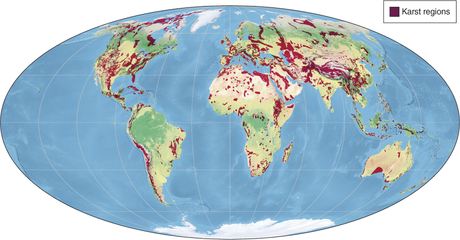
Figure 15.10
486
A Riddled Surface: Karst Topography
On August 12, 2013, a sinkhole opened up beneath a resort home near Orlando, Florida (Figure 15.11A). Over a span of about 15 minutes half of the house had collapsed into the 60-
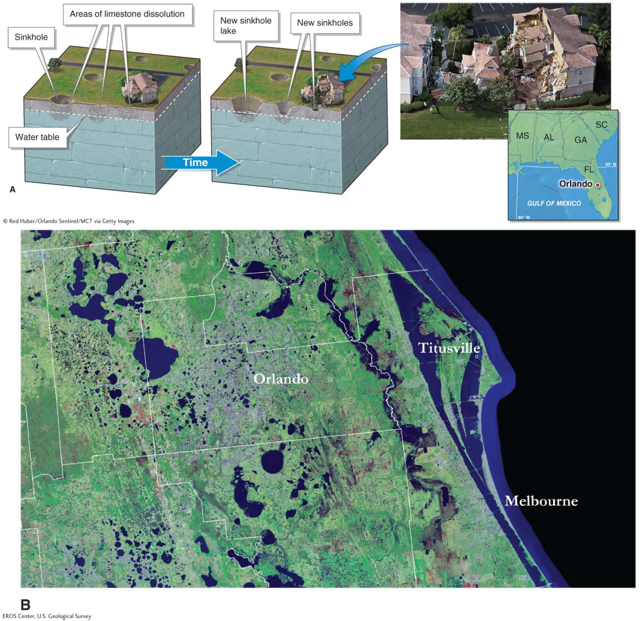
Figure 15.11
Question 15.4
Why are homes sometimes swallowed by the ground?
Sinkholes are depressions that form when carbonate rocks dissolve. Any unlucky structures sitting over a forming sinkhole can be pulled into them.
A sinkhole (or doline) is a depression in Earth’s surface that results from the weathering of carbonate rock underground. In the United States, sinkholes are particularly common in Kentucky, Tennessee, and Michigan. Yet Florida has the greatest number of sinkholes. Between 2006 and 2010, Florida insurance companies paid out almost $2 billion for damage done by the state’s sinkholes. Florida also has the greatest number of sinkhole lakes: sinkholes that are filled with water, as shown in Figure 15.11B.
sinkhole
A depression in Earth’s surface resulting from the weathering of carbonate rock underground.
sinkhole lake
A sinkhole that has filled with water.
Many limestone karst regions are riddled with steep-
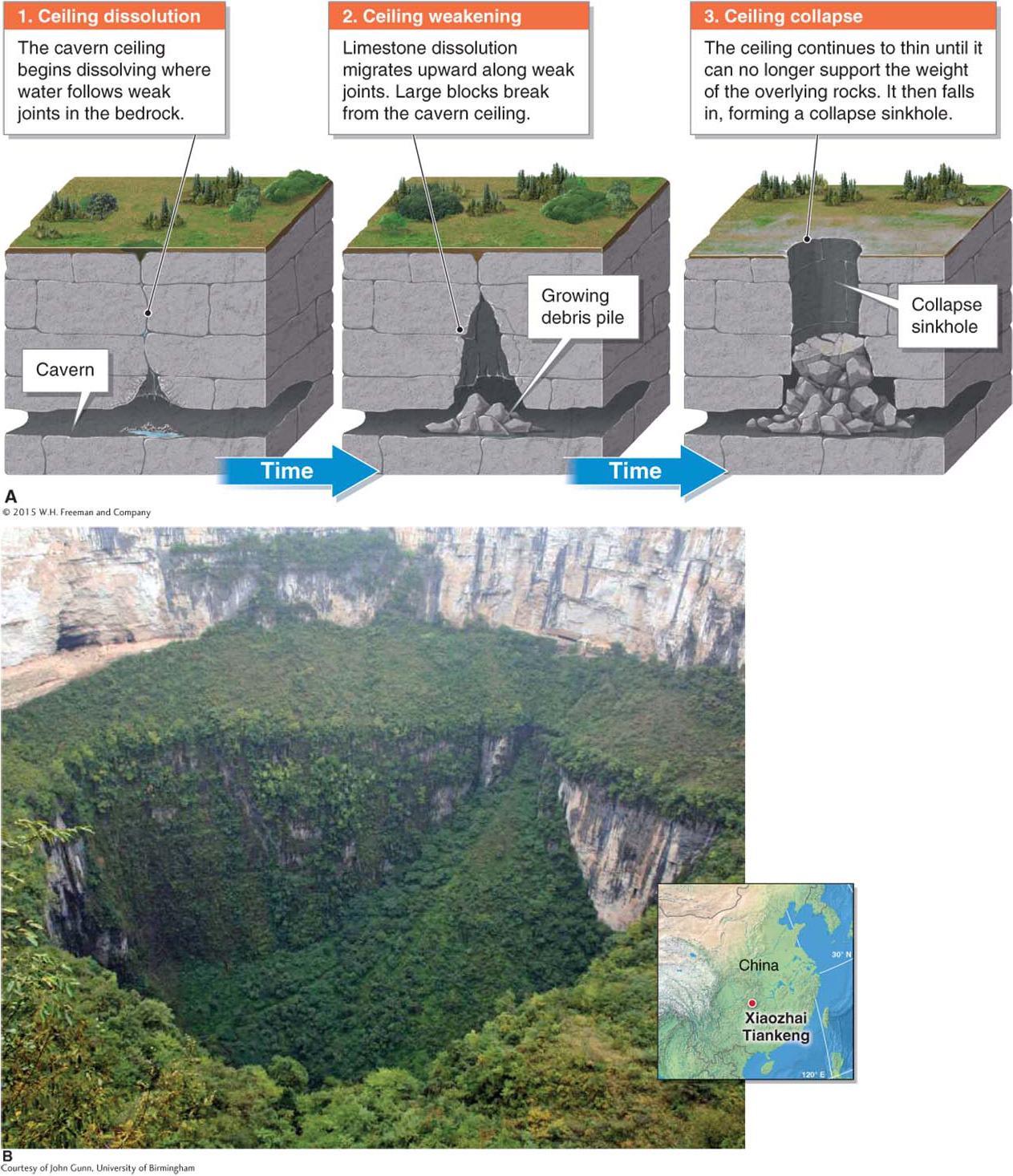
Figure 15.12
collapse sinkhole
A sinkhole formed where the ceiling of a cavern has collapsed.
487
488
When the lowest level of a collapse sinkhole lies below the water table, a cenote forms. Most of the Yucatán Peninsula of Mexico is composed of limestone, and it has many karst features, including cenotes (Figure 15.13). Another spectacular example of a collapse sinkhole is explored in Picture This.
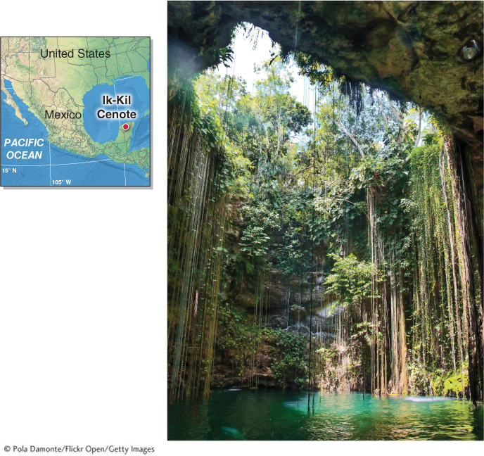
Figure 15.13
In karst regions, flowing groundwater often excavates subterranean caverns. The fastest dissolution of limestone occurs just below the water table, where the groundwater acidity is highest. As a result, limestone caverns often run parallel to the ground surface, following bedding planes in the limestone. If the water table drops, a new series of horizontal caverns may start forming below the old series of caverns (Figure 15.14).
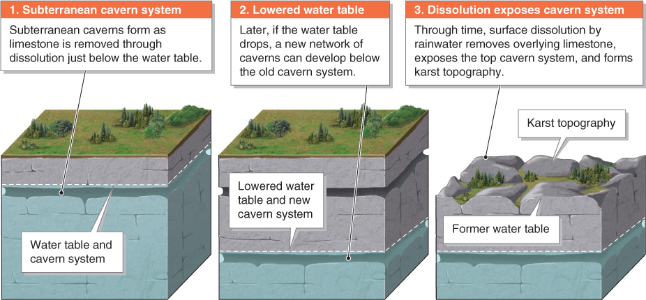
Figure 15.14
 Animation
Karst topography
http:/
There are few surface streams in karst regions because water flows underground through cavern systems. The surface streams that are found there usually flow for only short stretches, then disappear into the ground. A stream that leaves the ground surface and flows into subterranean channels is called a disappearing stream (Figure 15.15).
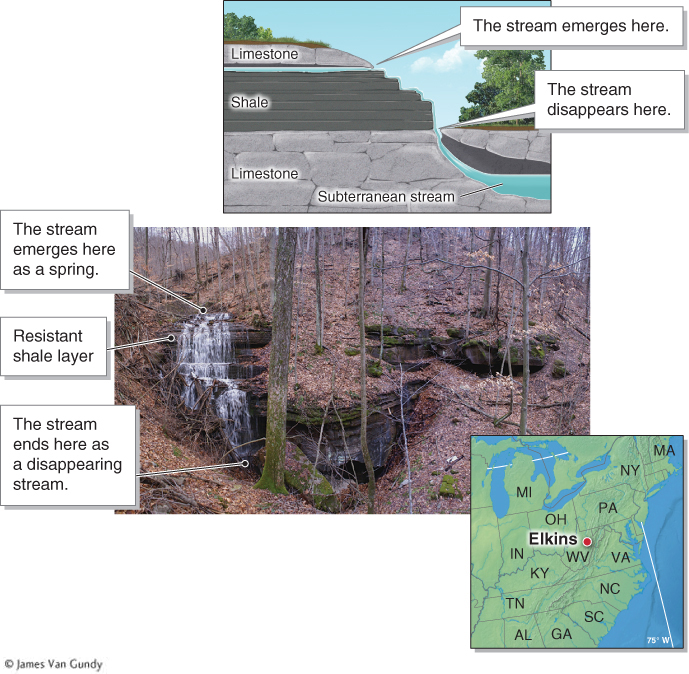
Figure 15.15
disappearing stream
A stream that leaves the ground surface and flows into subterranean channels.
Question 15.5
What is a disappearing stream?
A disappearing stream is a stream that leaves the ground surface and flows into a hidden subterranean cavern system.
Many unique landforms are associated with limestone karst topography. Limestone pavement, for example, is a type of bare surface consisting of deeply weathered limestone (Figure 15.16). It is found where exposed limestone bedrock has been dissolved by rainwater and an overlying cover of soil and vegetation is absent.
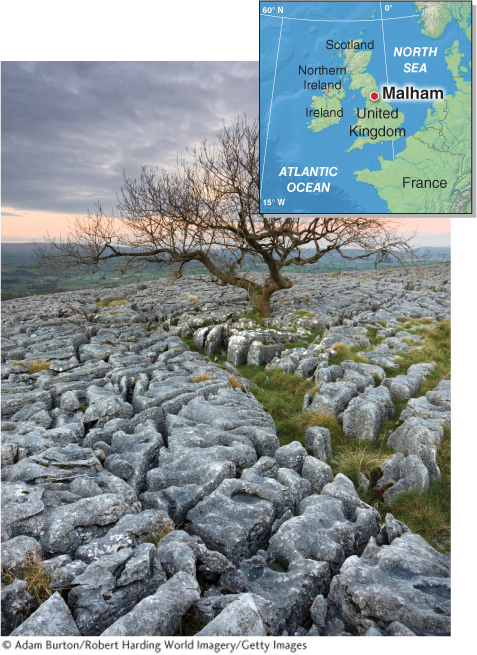
Figure 15.16
Picture This
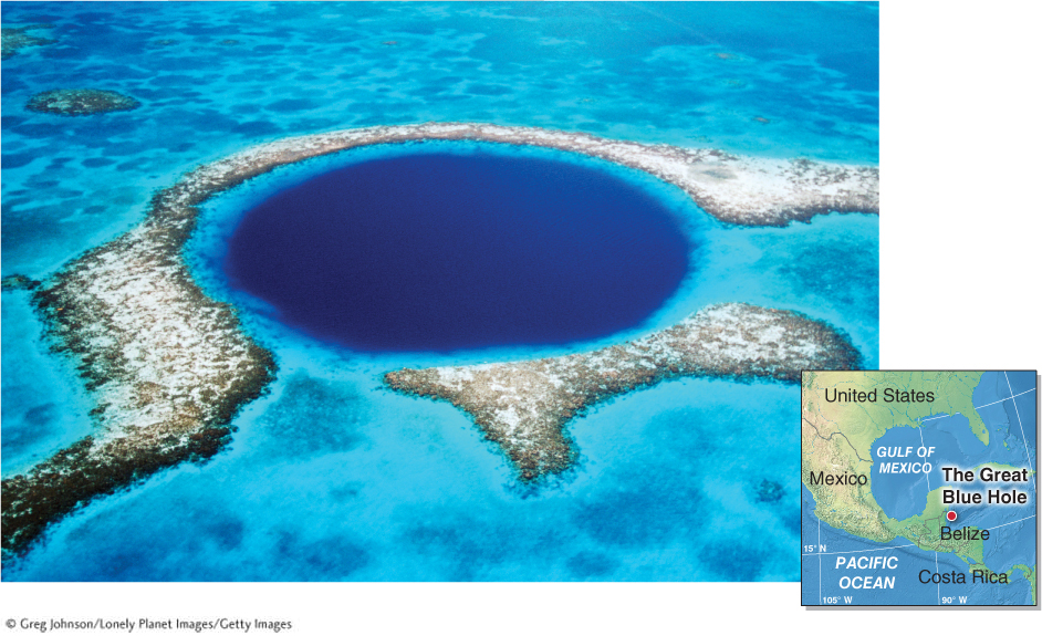
The Great Blue Hole, Belize
The Great Blue Hole, in Belize, is a submarine collapse sinkhole that formed during the most recent glacial period, when sea levels were about 85 m (280 ft) lower than they are today. As the continental ice sheets melted about 10,000 years ago (see Section 6.2), sea level rose, and the collapse sinkhole was inundated with seawater. Coral reefs now fringe the sinkhole and support rich marine biodiversity. The Great Blue Hole, which is about 300 m (984 ft) across and 125 m (410 ft) deep, is among the largest sinkholes on Earth.
Consider This
Question 15.6
P0QTGsEvA8Cr1gTpiQy55vbsdpFmFL7ztC/qgZzUZXbfMc7bsWsDpQ==Question 15.7
ww3+vb0XbfXcmTDTU0qU48dCKOs3yAXzhiuGrgMVgt8A7fV3h8opmBRInLu4DevoBvplPneiZTqWqwzOmEIj+r28GIhVQDth17Uczw==
489
490
Cockpit karst is a limestone surface with a topography dramatically different from limestone pavement. Cockpit karst consists of vegetated rounded hills formed by limestone weathering (Figure 15.17A).
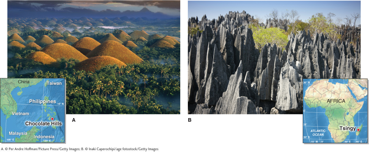
Figure 15.17
In other cases, rather than rounded hills, karst processes create karst spires. In Madagascar, a “stone forest” called the Tsingy seemingly grows from the ground. Sharp pinnacles and pointed spires of limestone form a labyrinthine landscape that covers several thousand square kilometers and is almost completely inaccessible to people (Figure 15.17B).
As a landscape’s surface is lowered by karst processes, pinnacles of tower karst may form where weak vertical joints focus the dissolution of the rock along vertical planes (Figure 15.18).
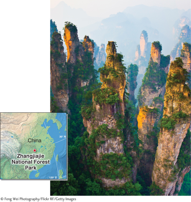
Figure 15.18
A Hidden World: Subterranean Karst
In regions with limestone bedrock, subterranean caverns are common. In the open air of karst caverns, water seeping from the ground surface outside enters through the cavern ceiling and drips and flows across the ceiling and down the walls. Minerals such as calcium carbonate are slowly precipitated out of the flowing and dripping water. These minerals accumulate into formations called speleothems (or cavern formations).
speleothem
A cavern formation that forms by precipitation of calcium carbonate.
Dripstones are speleothems formed by precipitation of calcium carbonate by dripping water. Flowstones are sheetlike calcium carbonate deposits formed along the edges that water drops flow down before they drip. Dripstones and flowstones, which form extremely slowly, are commonly several hundred thousand years old. Among the most common dripstones are stalactites, formations that grow from the ceiling downward. Conversely, stalagmites grow from the cavern floor upward as water drips from stalactites. A limestone column is a cylindrical dripstone that results when a stalactite joins with a stalagmite. Stalactites often form a hollow structure called a soda straw when they first begin forming. Examples of these speleothems are shown in Figure 15.19.
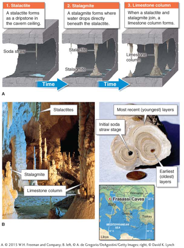
Figure 15.19
stalactite
A speleothem that grows from the ceiling of a cavern downward.
stalagmite
A speleothem that grows from the floor of a cavern upward.
limestone column
A cylindrical speleothem resulting when a stalactite joins with a stalagmite.
491
When the climate is wetter, more water drips from speleothems, and calcium carbonate builds slightly faster than during dry periods. If, however, the water table rises enough to flood the cavern again, the speleothems will stop growing. Similarly, if water stops flowing into the cavern and the ceilings and walls become dry, speleothem growth will stop. For this reason, speleothems play an important role in paleoclimatology (see Section 6.2). They have been used to provide detailed climate reconstructions spanning several hundred thousand years. If the average rate of speleothem growth is known, the age of the speleothems can be estimated (Crunch the Numbers).
CRUNCH THE NUMBERS: Calculating the Age of a Speleothem
CRUNCH THE NUMBERS: Calculating the Age of a Speleothem