FLOWING WATER: Fluvial Systems
16
508
Chapter Outline
16.1
Stream Patterns
16.2
Downcutting by Streams: Fluvial Erosion
16.3
Building by Streams: Fluvial Deposition
16.4
Rising Waters: Stream Flooding
16.5
Geographic Perspectives: Dam Pros and Cons
509
LIVING PHYSICAL GEOGRAPHY
Why are major cities often located on rivers?
What is the largest river in the world?
Why are river rocks rounded?
What are swamps and bayous?
510
THE BIG PICTURE
Flowing water is the most important agent of erosion. Streams erode Earth’s surface and also build it up by depositing the sediments they transport.
LEARNING GOALS
After reading this chapter, you will be able to:
16.1
Identify the different geographic patterns of stream systems.
16.2
Explain how streams evolve through time as they erode Earth’s surface.
16.3
Discuss landforms resulting from the deposition of sediment by streams.
16.4
Describe two modes of stream flooding and explain how people reduce their vulnerability to flooding.
16.5
Assess the benefits and drawbacks of dams.
THE HUMAN SPHERE:
People and Floodplains
PEOPLE HAVE ALWAYS LIVED near large rivers. Early subsistence agriculture and the first sedentary (nonmigratory) human societies began over 10,000 years ago on the crescent of land called the Fertile Crescent formed by the lower Nile River and the Tigris and Euphrates rivers in ancient Mesopotamia. Today, this area spans Iraq, western Iran, southern Turkey, Syria, Lebanon, Israel, and Egypt (Figure 16.1).
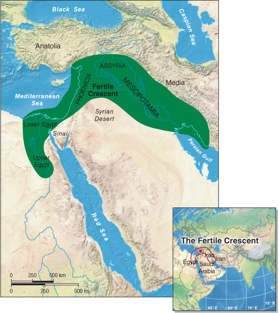
Figure 16.1
Question 16.1
Why are major cities often located on rivers?
Rivers provide many societal benefits, including flat land for settlement, fertile soils, and access to inland areas from the coast.
The land in the floodplains along most large rivers is flat and desirable for settlement. Floodplains are the areas of flat land near a stream that experience flooding on a regular basis. They are composed of deep layers of sediment, as we will see in Section 16.3. The soils deposited by occasional flooding, called alluvial soils, or entisols (see Section 9.1), are rich and fertile. Rivers also provide corridors for transportation inland from the ocean. Because of these benefits, many major cities have been established along rivers: Familiar examples include Buenos Aires, Cairo, Jakarta, London, Madrid, Paris, Portland (Oregon), Rome, Shanghai, Tokyo, and Washington, D.C.
floodplain
The area of flat land near a stream that experiences flooding on a regular basis.
A problem arises, however, when rivers overflow their banks. Like many physical geographic phenomena, rivers are spatially and temporally dynamic systems. Their flat floodplains were built as they spilled out of their channels many times in the past and deposited the sediments they carried.
In this chapter, we explore the influence of rivers in shaping Earth’s surface and in shaping people’s lives. We first examine the surface geographic patterns formed by stream channels and see how streams cut into and erode Earth’s surface. Next, we look at landforms built as streams deposit their sediments. Finally, we explore the benefits and costs of blocking streams with dams.
511