16.1 Stream Patterns
Identify the different geographic patterns of stream systems.
Water is one of the most important compounds on Earth. In the hydrologic cycle, water evaporates from the oceans, enters the atmosphere, condenses into clouds, and precipitates over land (see Section 3.1). The resulting surface runoff flows back to the oceans in streams. A stream is a channel in which water flows downhill by the force of gravity. The term stream includes flows from the smallest rivulet of water to the mightiest rivers on Earth. Depending on the geographic region, streams are also called rivers, brooks, runs, creeks, washes, wadis, and many other names.
stream
A channel in which water flows downhill by the force of gravity.
Drainage Basins
Streams that are connected together form a drainage basin. A drainage basin (or watershed) is a geographic region drained by a single trunk stream and its tributaries. A trunk stream is a single large stream into which smaller tributaries merge. A tributary is a stream that joins with other streams to form a larger stream. Figure 16.2 illustrates these concepts using the Amazon River.
drainage basin
A geographic region drained by a single trunk stream and the smaller tributaries that flow into it.
trunk stream
A single large stream into which smaller tributaries merge.
tributary
A stream that joins with other streams to form a larger stream.
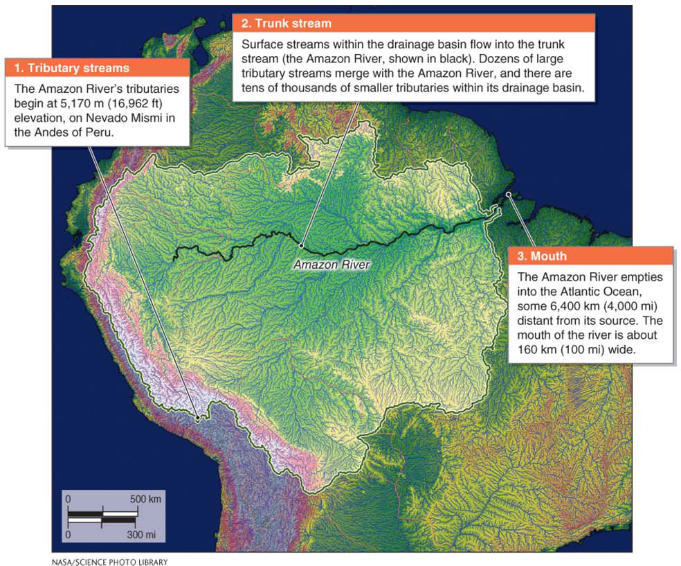
Figure 16.2
Topography determines the boundaries of drainage basins. There is no set limit to their size: The size of a drainage basin depends on the geographic scale used to define it, as illustrated in Figure 16.3. A single drainage basin can cover a small hillside or occupy much of a continent.
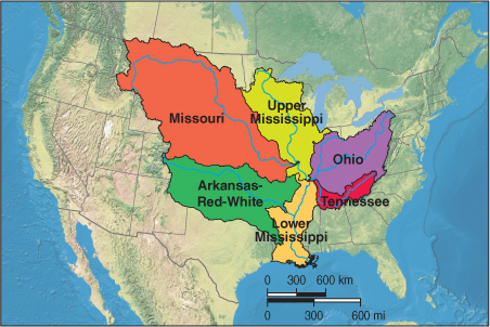
Figure 16.3
512
A ridge or highland that separates drainage basins and defines their boundaries is called a drainage divide. A ridge or highland that separates drainage systems that empty into different ocean basins is called a continental divide (Figure 16.4).
drainage divide
A ridge or highland that separates drainage basins and defines their boundaries.
continental divide
A ridge or highland that separates drainage systems that empty into different ocean basins.
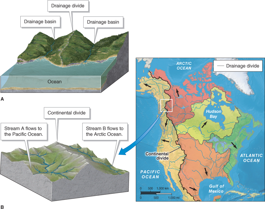
Figure 16.4
Most streams drain into the oceans. But some do not. Some drainage basins have no outlet to the oceans. Instead, streams flow into a low-
internal drainage
A drainage pattern in which streams terminate in a low-
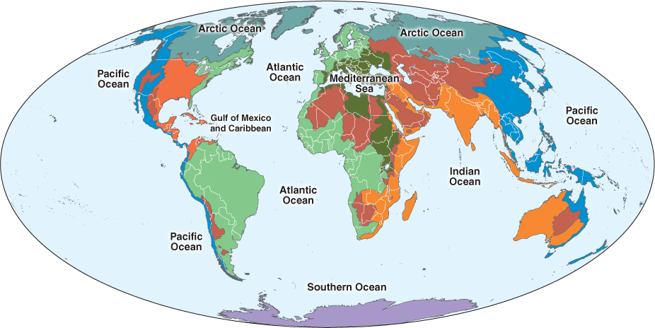
Figure 16.5
513
Internal drainage systems are located in arid regions where evaporation rates exceed precipitation. The water that collects in a large terrestrial basin can leave only through evaporation or infiltration into the ground. During evaporation, salts and other dissolved minerals remain behind in the standing water. For this reason, many internal drainage basins contain saline lakes (Figure 16.6).
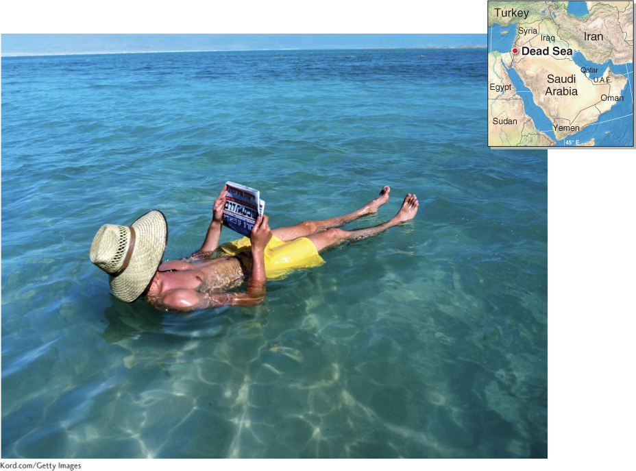
Figure 16.6
514
Trunk streams and their tributaries form different drainage patterns within a drainage basin depending on the topography and the type of surface over which they are flowing. Although there are many different kinds of drainage patterns, six common ones are illustrated in Figure 16.7. The most common drainage pattern is dendritic drainage, in which the pattern of the streams resembles the branches of a tree.
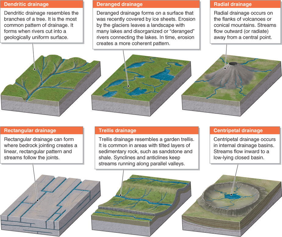
Figure 16.7
dendritic drainage
A pattern of streams within a drainage basin that resembles the branching of a tree.
Stream Order and Stream Permanence
Arthur Strahler (1918–
stream order
A numerical system used to rank stream size based on the number of tributaries flowing into a stream.
headwaters
The region where a stream originates.
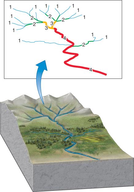
Figure 16.8
About 80% of all streams are third-
Question 16.2
What is the largest river in the world?
The Nile River in Africa is the longest river. The largest river by volume is the Amazon River.
Stream Permanence
Stream order is related to stream permanence. A stream that runs dry during part or most of the year is an intermittent stream. Many first-
intermittent stream
A stream that runs dry during part or most of the year.
ephemeral stream
A stream that flows briefly after heavy rainstorms.
permanent stream
A stream that flows all year.
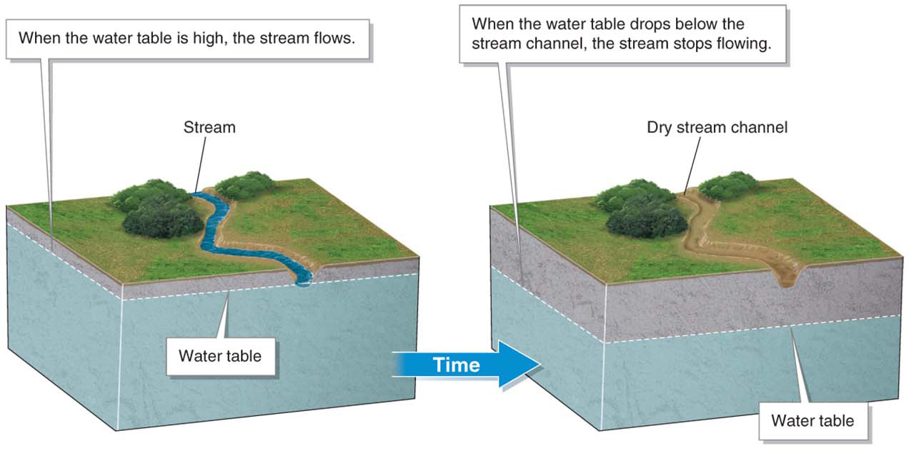
Figure 16.9
515
Ephemeral streams are most common in arid regions, where thunderstorms bring sudden downpours. Ephemeral streams go by the informal names of arroyos, dry washes, or wadis, depending on the country in which they occur. Ephemeral streams are short-
An exotic stream is a permanent stream that originates in a humid region and flows through an arid region where there is little precipitation. The Nile River, for example—
exotic stream
A permanent stream that originates in a humid region and flows through an arid region.
Anthropogenic Intermittent Streams
Diversions of water from streams by people have made many formerly permanent streams run low or run dry. When this happens, human conflict may ensue, particularly where a stream crosses state or international borders. In the Middle East, for example, Turkey diverts water from the Tigris and Euphrates rivers near their headwaters, causing political friction with downstream neighbors such as Iraq.
516
The Colorado River and many of its tributaries in the southwestern United States provide water for 30 million people in seven western states. Water diversions are so extensive in this area that during dry periods, the Colorado River does not have enough water flowing in its channel to reach the Gulf of California in Mexico, where it emptied historically. Picture This highlights the Gila River, a tributary of the Colorado River, in this context.
Picture This
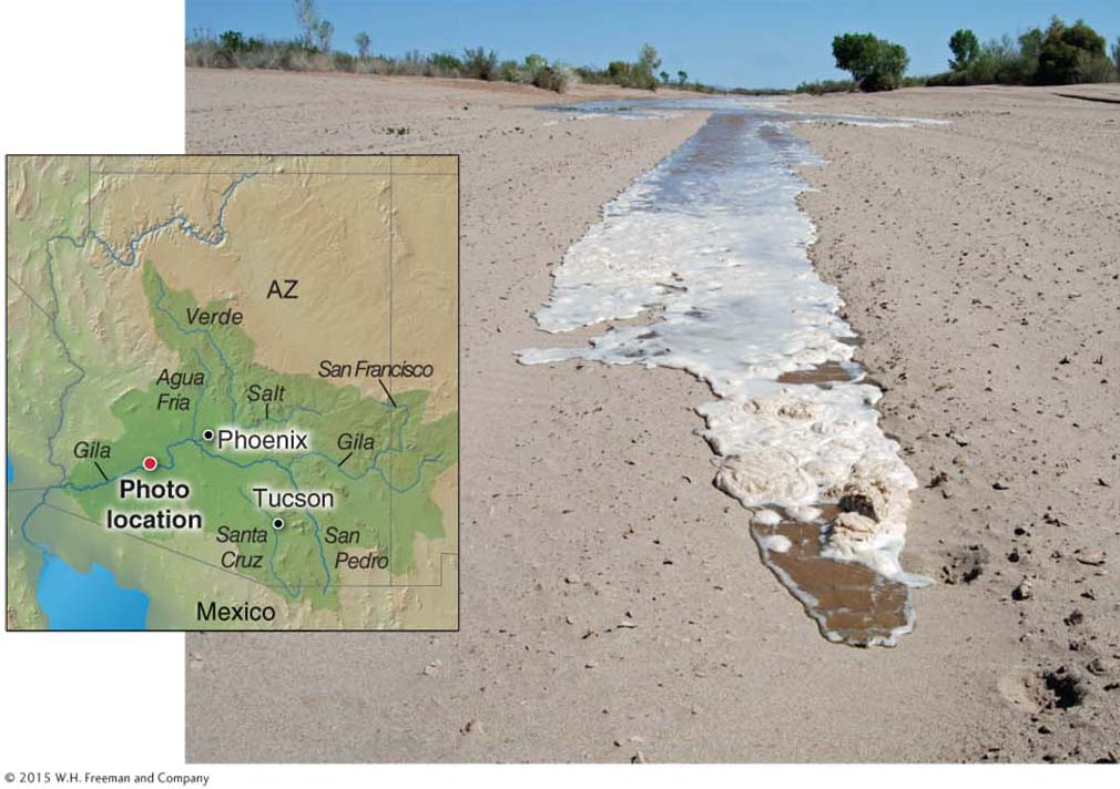
The Gila Reborn
This muddy trickle of water is the brief rebirth of the Gila River. Like the Colorado River, the Gila River is an exotic stream where it flows through the desert. The Gila River’s headwaters are in the relatively wet highlands of western New Mexico. As it flows out of these mountains, several tributaries join it. In the past, the Gila flowed all the way to, and emptied into, the Colorado River near Yuma, Arizona. But water diversions now prevent the Gila from reaching the Colorado in all but the wettest years. Typically, the Gila runs dry downstream of Phoenix. In 2010, however, heavy rains in its headwaters allowed the Gila to fill its streambed downstream of Phoenix, if only for a little while, the first time it had done so in five years.
Consider This
Question 16.3
W0i0ewGPsIBEJCVxhsnXsYgtG1ITN9l9zniZGHeSB98ZcIc13VV0F7JytbkzNjZ3Yb6sxXjBN03/VbyfcU6vK2y7HtJFwTPaUouJnhX+kpeV+tGTjVaDOEGzdIO9xTQ3Question 16.4
RKIikXidFKN9uGhuVmLFOu4O1tglU1OQ8BHg3Vl1gwSFJXAH794GH+L6ENzvJkDQ1pfWGNcMSiZ0G+3QhI3x2XxvS3+u6v8RTTa2bcLco/4qqBSHY/2LGM8Epe2c/ee4zJrbyTcxk++ZehgkaLt3o2jUbuY=