16.3 Building by Streams: Fluvial Deposition
Discuss landforms resulting from the deposition of sediment by streams.
Streams shape Earth’s surface not only by cutting into it, as we have seen, but also by transporting and depositing sediments downstream. Many important natural fluvial landforms are built by accumulations of stream-
Dropping the Load: Stream Sorting
As long as stream capacity and stream competence are maintained, the stream load will continue to be transported. Where stream capacity or stream competence is reduced, material carried by the stream begins to settle out. Where a stream stops flowing at base level, it loses all kinetic energy, and all the material it carries, except its dissolved load, settles out.
Sediments are sorted by size as they are deposited by streams. The heaviest material in transport settles out first. The largest boulders are high in the drainage basin because they are too heavy to be carried very far. They eventually break into smaller and lighter fragments that will move more easily. Cobbles and pebbles will be moved farther downstream than boulders. Sand, silt, and clay settle out of the water still farther downstream.
To get a sense of how the sorting process works, imagine a white quartz boulder in a stream channel where all other rocks are dark. Because the boulder is white, we can easily see it and follow it from a high mountainous area and on downstream as it is broken into ever-
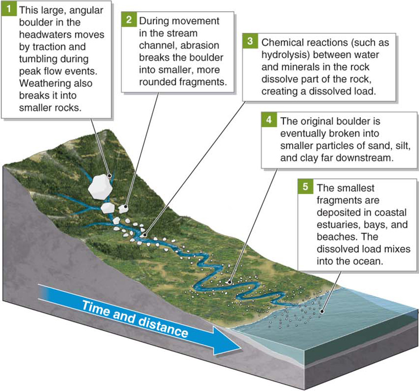
Figure 16.24
alluvium
Sediments deposited on a floodplain by a stream.
 Animation
Stream sorting
http:/
Places of Deposition
If a stream’s capacity and competence become insufficient to carry all the sediments that enter the stream, the sediments will settle out in the stream channel and accumulate. The buildup of sediments in a streambed is called aggradation. Aggradation in the low-
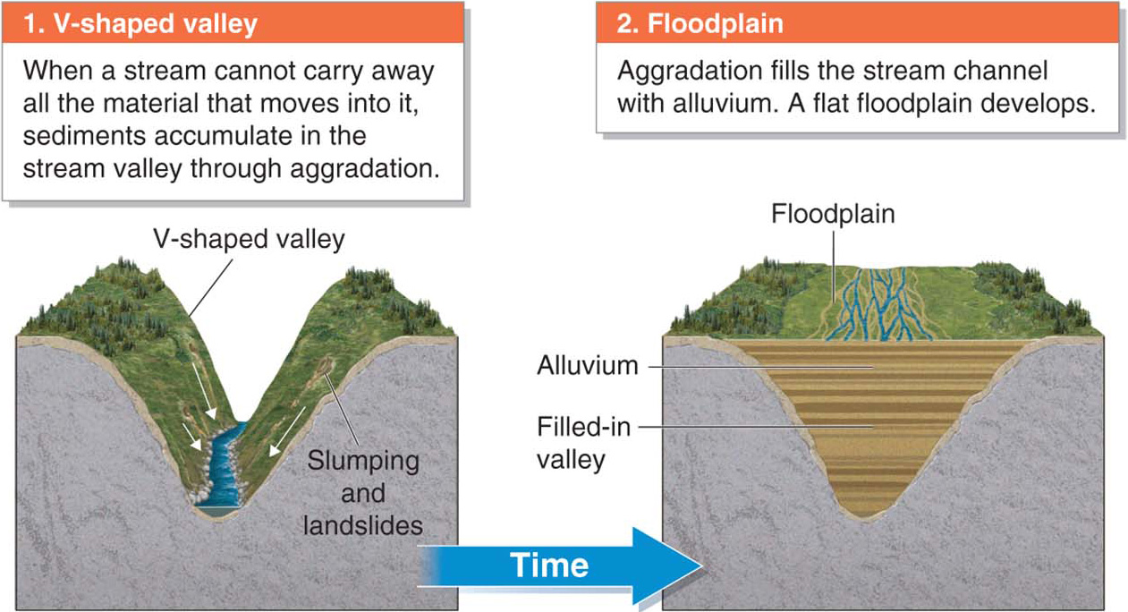
Figure 16.25
aggradation
The buildup of sediments in a streambed.
Sediment input into a stream channel increases where vegetation is removed by fire or human activity. Sediments from unpaved roads in steep terrain can wash into streams as well. During the Gold Rush in California in the middle 1800s, miners blasted the hillsides with water in search of gold. This hydraulic mining eroded the slopes and overwhelmed the streams with sediments (Figure 16.26).
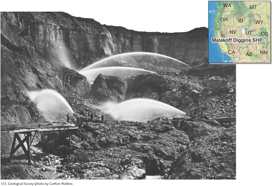
Figure 16.26
527
Aggradation also occurs where streams flow out of glaciers. Glaciers flow downhill and grind the bedrock beneath them into rock fragments (see Section 17.3). The glacier’s outlet stream can move this material only during peak summer flow periods. At most times, the stream occupies only a small portion of the streambed, flowing around elongated islands of gravel and sand. Such streams that form intertwining channels around sediments in the streambed are called braided streams (Figure 16.27).
braided stream
A stream that forms intertwining channels around sediments in the streambed.
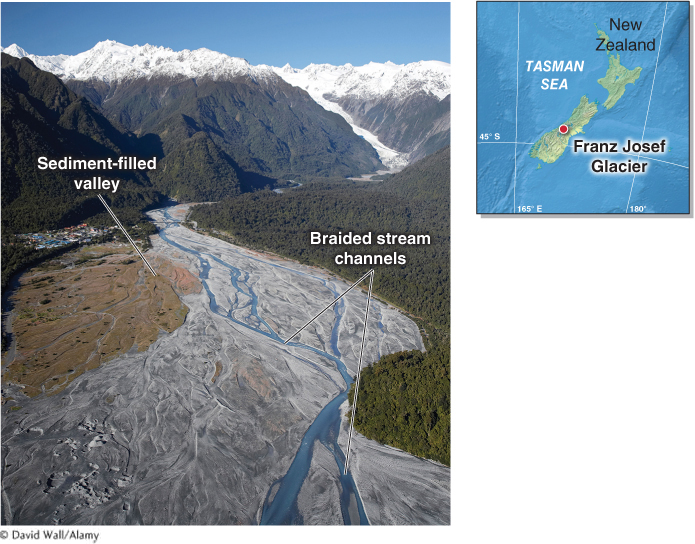
Figure 16.27
Streams may also lose energy after they flow through a steep-
alluvial fan
A gently sloping accumulation of sediment deposited at the base of a mountain by an ephemeral stream in arid regions.
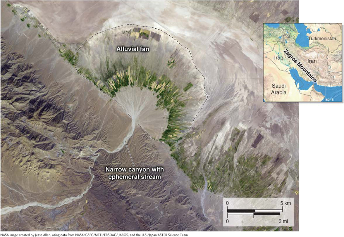
Figure 16.28
528
Stream Meanders and Floodplains
A meander is a looping bend in a stream channel that forms on a floodplain. Meanders develop when the fastest-
meander
A looping bend in a stream channel on a floodplain.
cut bank
The outside edge of a meander, where erosion exceeds deposition.
point bar
An accumulation of silt, sand, and gravel that forms at the inside edge of a stream meander, where deposition exceeds erosion.
Stream meanders are spatially dynamic features. Through time, stream channels shift across the floodplain, forming new meanders and abandoning old ones (Figure 16.29). In places where a meander is cut off from the stream channel and the channel is abandoned, a water-
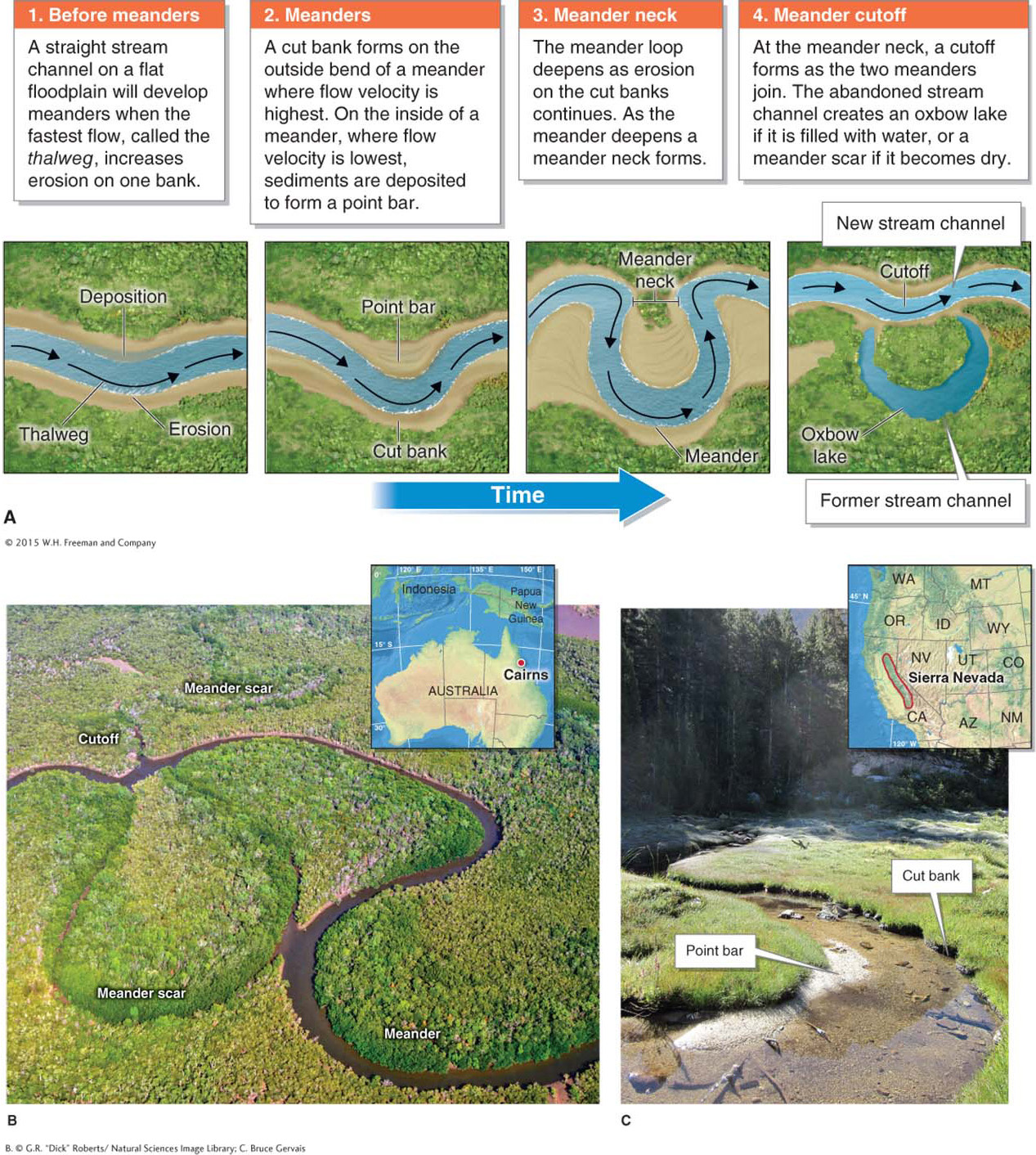
Figure 16.29
Animation
Stream meanders
http:/
oxbow lake
A water-
When a stream overflows its banks and floods, the standing sheet of water on the floodplain has no energy to carry its suspended load of silts and clays. These sediments settle out of the floodwaters and form deposits of alluvium. The smallest particles (clay and silt) are carried farthest away from the stream channel and accumulate on the floodplain. The largest particles (sand and gravel) accumulate near the stream channel in raised barriers that parallel the stream channel, called natural levees (Figure 16.30).
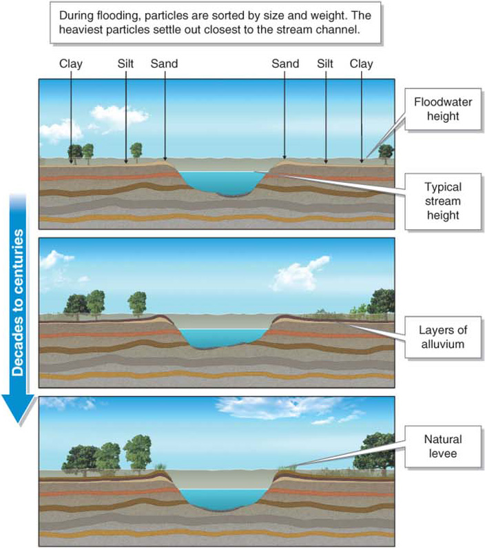
Figure 16.30
Animation
Natural levees
http:/
Tributaries entering a floodplain sometimes flow parallel to the trunk stream because they cannot flow over the higher floodplain and natural levees bordering the trunk stream channel. As a result, permanently flooded areas called wetlands (also called swamps, backswamps, or bayous) and yazoo streams form (Figure 16.31).
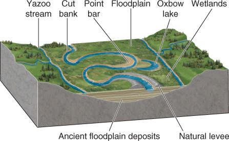
Figure 16.31
529
530
Question 16.9
What are swamps and bayous?
Swamps and bayous are informal names for permanently flooded lowlands. Scientists call these areas wetlands.
The End of the Line: Base Level
All streams stop flowing at base level. Water in all streams eventually finds the oceans, with the exception of those in internal drainage systems (see Section 16.1).
Along the way to the ocean, natural dams (such as beaver dams or landslide debris) may form a temporary base level (also called a local base level) as a pond or lake develops behind the obstruction. Over time, fluvial erosion will eventually cut through the obstruction, and the stream will flow freely again.
 Streams are also dammed by people. Damming creates an artificial lake called a reservoir. Stream capacity and stream competence are zero in lakes and reservoirs, and as a result, all sediments settle out. At the end of this chapter, the Geographic Perspectives further explores the problem of sedimentation in reservoirs.
reservoir
An artificial lake.
A delta is an accumulation of sediments that forms where a stream reaches base level. Because of the amount of material deposited in deltas, the stream channel often becomes blocked, forcing the stream into a new channel around the sediments, as also occurs in a braided stream. In a delta, the trunk stream can shift and form a smaller branching network of streams called distributary channels, or distributaries. As shown in Figure 16.32, tributaries occur at the headwaters of a drainage basin, and distributaries occur in the delta.
delta
An accumulation of sediment formed where a stream reaches base level.
distributary
One of a branching network of streams in a delta.
distributaries
A branching network of streams in a delta.
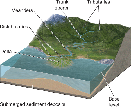
Figure 16.32
Stream deltas are so named because the triangular shape of some deltas resembles that of the Greek letter delta (Δ), but not all deltas take this shape (Figure 16.33). A delta’s shape depends mainly on the stream’s suspended load and on the influence of currents at the stream’s mouth. Arcuate deltas are triangular and often have a braided or branching pattern of distributaries. The distributaries in a bird’s foot delta resemble toes on a bird’s foot.
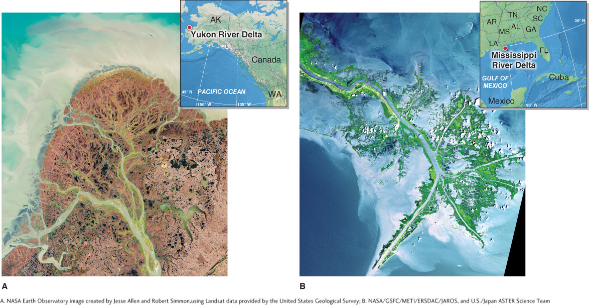
Figure 16.33
The largest deltas form where coastal ocean currents are at a minimum and major streams carry a heavy load of suspended sediments. Where coastal currents are strong, however, river mouths have small or no deltas because the currents carry sediments away. The Columbia River, on the border of Oregon and Washington, the Congo River, in western Africa, and the Amazon River are examples of major streams with no coastal deltas.
531
In many deltas, the land elevation drops due to natural subsidence: the lowering of land elevation through the compaction of sediments. Deltas keep pace with natural subsidence as their streams continually deposit new sediments that build up the land. As long as sediments are renewed by fluvial deposition, there is an equilibrium between subsidence and sedimentation.
subsidence
Lowering of land elevation through compaction of sediments.
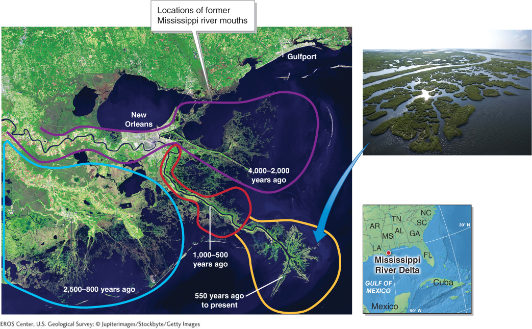
When artificial levees are built around a stream to control water flow, however, this equilibrium is disrupted. With levees in place, the river can no longer flood and form new meanders. The river’s sediments are carried through and past the delta to the seaward edge and are deposited offshore, rather than in the delta. The interior delta becomes sediment starved, and as it sinks, the sea gradually encroaches on the land. Picture This (below) highlights the effects of this process in New Orleans, which is built on the Mississippi River delta.
532
Picture This
Vanishing Wetlands and a Sinking City
New Orleans is sinking. The past equilibrium between sedimentation and subsidence in the Mississippi River delta was disrupted when artificial levees were built around the river, mostly by the U.S. Army Corps of Engineers, in the 1930s and 1940s. In the past, the mouth and distributaries of the Mississippi River shifted every few hundred years to a new location, building the delta with new sediments. In this satellite image, the former positions of the river mouth are outlined in different colors, and their ages are given. Once the levees and upstream dams were in place, the trunk stream channel was stabilized to protect New Orleans. The river could no longer shift, flood, and build.
Some parts of New Orleans are now 2 to 6 m (3 to 12 ft) below sea level, and the coastal wetlands are riddled with holes and canals that were not present historically (inset). In many regions, the wetlands cannot grow fast enough to keep pace with subsidence. Because of the loss of coastal wetlands as well as rising sea level (see Section 19.3), New Orleans is increasingly vulnerable to flooding by hurricane storm surges.
Consider This
Question 16.10
MFYFWqFp68MfFWd/YuqJlm2/jHl+KF239TenLQtiBRT69oFJbHgzEZ+P+JmOBrtKan7rBH9k1XxVaDAmwOMreBcpi7FI6z4j4wXWgEaEXmfJT5oBuG9scdijSdfeeB9Ecaw07XQiMxcEr9bTV61/ji+LN1M=Question 16.11
62XHLA4u3QVfydz/mXdv+ckL7GIUKHGYnCMTS0F5ObI=