17.2 About Glaciers
Explain how glaciers form and move and describe different glacier types and their geographic settings.
In Section 6.2, we saw that Earth’s climate was once much colder than it is today and that ice sheets once covered large areas of the Northern Hemisphere. Evidence of these colder conditions can be found in the form of sediments composed of unsorted rock fragments. Such sediments are commonplace throughout northern Eurasia and northern North America far south of today’s periglacial environments. These sediments range in size from massive boulders to tiny silt particles. In some places, large boulders seemed to have been placed randomly across the countryside. Many of them do not match the local bedrock, indicating that they came from far away (Figure 17.7).
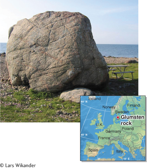
Figure 17.7
Originally, scientists thought water in streams created these sediments and transported these large boulders. But how could water have transported such massive boulders? Furthermore, the sediments that streams deposit are sorted by size (see Section 16.3). Why were these sediments unsorted? In 1837, the Swiss-
Large boulders transported long distances by a glacier are called glacial erratics. Originally, glacial erratics and similar deposits of gravel and sand were attributed to the great biblical flood. It was thought that the boulders “drifted” into place, and they were therefore called drift. This term has persisted: Today, all deposits relating to glaciers and the streams flowing out of glaciers, from the largest boulders to the smallest silt particles, are collectively called drift.
glacial erratic
A large boulder transported a long distance by a glacier.
551
What Is a Glacier?
A glacier is a large mass of ice that is formed from the accumulation of snow and that flows slowly downslope. Glaciers form one snowflake at a time, over long periods. Glaciers form where snow accumulates and is compressed by gravity to granular snow, then firn, then glacial ice (Figure 17.8). Glacial ice is ice that has an air content of less than 20%. This process can take place only where snowfall does not melt completely in summer, so that snowfall accumulates year after year. Glaciers do not form in periglacial environments because snow melts in summer or because there is insufficient snowfall. In addition, the slope where snow is accumulating cannot be too steep. If it is, the snow will slip downslope in avalanches rather than accumulate.
glacier
A large mass of ice that is formed from the accumulation of snow and flows slowly downslope.
glacial ice
Ice with an air content of less than 20%.
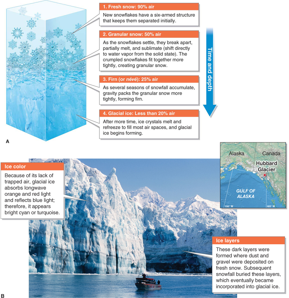
Figure 17.8
Question 17.5
How do glaciers form?
Glaciers form from the accumulation of snow. Where snow does not melt in summer and the slope is not too steep, a glacier may form.
552
The time it takes for glacial ice to form ranges from decades to centuries, depending on snowfall rates. Heavy snowfall produces glaciers more quickly.
Flowing Ice
Glaciers move downslope by the processes of basal sliding and plastic deformation. Basal sliding is what causes a piece of ice to slide down the sloped hood of a car, for example, as liquid water lubricates the base of the ice. We discussed plastic deformation in Section 11.3 in the context of the solid rock of Earth’s mantle, which slowly deforms and flows. Ice, too, is a solid, yet 60 m (200 ft) below the glacier’s surface, ice can slowly deform and flow. From the glacier’s surface down to 60 m, however, the ice is brittle. Cracks called crevasses form at the glacier’s surface where it flows over uneven bedrock (Figure 17.9).
crevasse
A crack that develops in the top 60 m of a glacier.
crevasses
Cracks that develops in the top 60 m of a glacier.
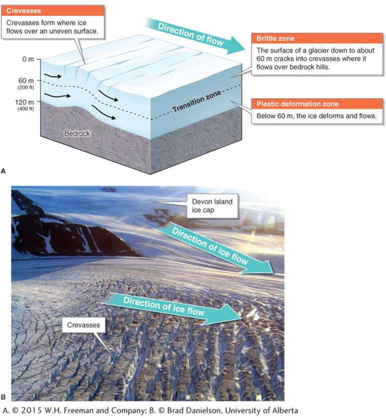
Figure 17.9
 Animation
Crevasses
http:/
553
Glaciers flow downslope at an average rate of a few centimeters per day. They do not always move steadily downslope, however. Their speed varies depending on several factors, including air temperature, the topography over which they are flowing, and the amount of water lubricating their base. In a glacial surge, the speed of a glacier accelerates for a period of a few days to a month or more. Glacial surge speeds can be on the order of 30 m (100 ft) in a single day, or even faster.
Like the water in a stream, the ice within a glacier flows at different speeds. Friction with the bedrock slows down the ice at the margins. The areas of fastest flow are farthest from the bedrock; namely, near the surface and central portions of the glacier, as illustrated in Figure 17.10.
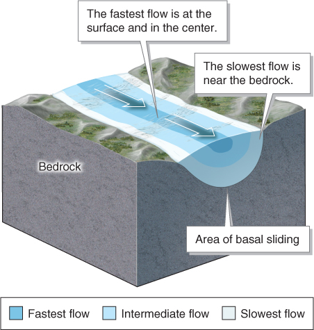
Figure 17.10
Inputs and Outputs: Glacier Mass Balance
A glacier’s ice volume changes over time. Glacier mass balance is the difference between inputs to a glacier that increase its ice volume and losses of ice that decrease its volume. As a whole, a glacier with a neutral mass balance has inputs (snowfall) and outputs (melting, sublimation, and iceberg calving) that are equal. When snowfall is less than ice loss, a negative mass balance exists for the glacier. When snowfall exceeds ice loss, a glacier has a positive mass balance.
glacier mass balance
The difference between inputs to a glacier that increase its ice volume and losses of ice that decrease its ice volume.
Along most of the length of a glacier, the mass balance is not neutral. At high elevations, more snow falls on the glacier than is lost through melting and sublimation. The area of a glacier where ice gain from snowfall exceeds ice loss is called the zone of accumulation. Below, in the zone of ablation, ice loss exceeds ice accumulation. At the terminus of a glacier, called the toe, more ice is lost than is gained through snowfall. The transition between the zone of accumulation and the zone of ablation is the equilibrium line (or snowline), the elevation at which a glacier’s ice accumulation and ice loss are equal over a period of one year (Figure 17.11).
toe
The leading edge and lowest elevation of a glacier.
equilibrium line
(or snowline) The elevation at which a glacier’s ice accumulation and ice loss are equal over the period of one year.
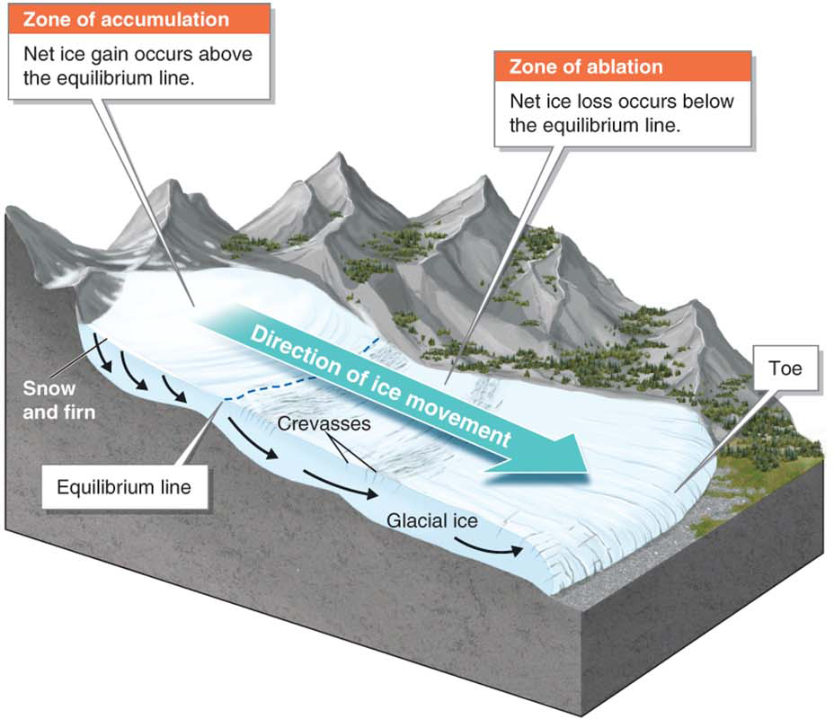
Figure 17.11
The forward movement of a glacier’s toe, usually downslope, is called glacial advance; upslope movement of a glacier’s toe is called glacial retreat. A glacier’s toe is continually advancing and retreating in response to changes in glacier mass balance. As shown in Figure 17.12, however, the ice within a glacier is always flowing downslope even when the toe is retreating upslope.
glacial advance
The forward (usually downslope) movement of a glacier’s toe.
glacial retreat
The upslope movement of the toe of a glacier.
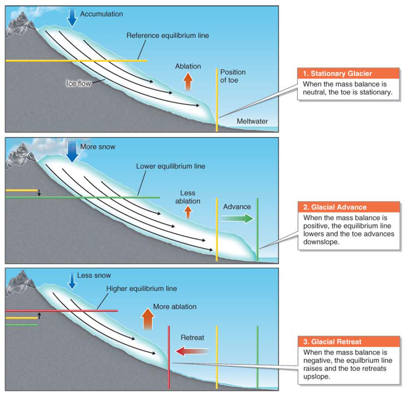
Figure 17.12
Animation
Glacier movement
http:/
554
Although the movement of a glacier’s toe largely reflects the mass balance of a glacier, glaciers are complex systems, and other factors can cause the toe to advance or retreat. For example, increased basal sliding can cause the toe of a glacier to move downslope.
Glaciers are sensitive to changes in atmospheric temperature. Several glaciers on the coast of Norway are experiencing positive mass balance because snowfall in the zone of accumulation is exceeding ice loss in the zone of ablation, and the toes of these glaciers are advancing downslope. Ironically, these glaciers are advancing in response to climate change. Warming of the atmosphere and sea surface is increasing evaporation from the North Atlantic Ocean and producing more snowfall for the glaciers.
In mountains worldwide, most glaciers are in retreat in response to atmospheric warming. These glaciers are experiencing a negative mass balance because ice loss in the zone of ablation exceeds snowfall in the zone of accumulation. Scientists are carefully measuring the mass balance of glaciers around the world and monitoring them as Earth’s climate changes (see Section 6.5). Figure 17.13 explores how scientists monitor glaciers.
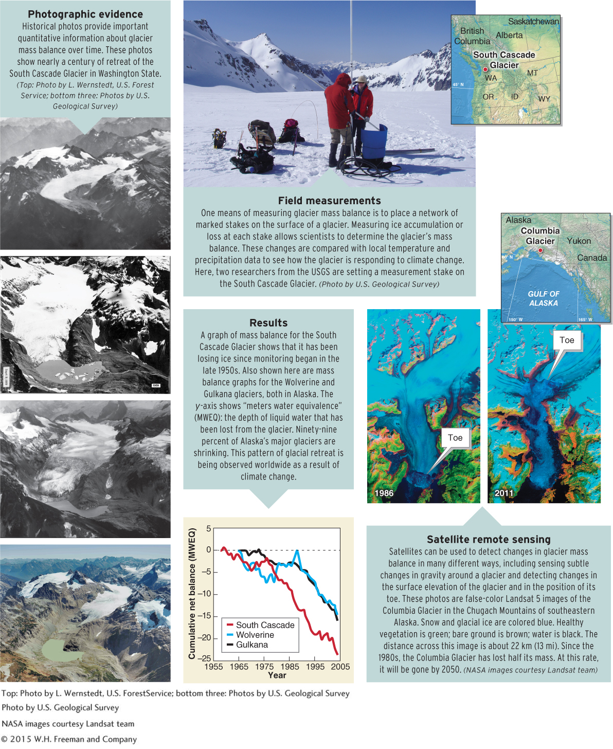
Figure 17.13
555
556
Two Types of Glaciers
Today, glaciers occur on every continent except Australia. They are found from the equator at high elevations to the Arctic and Antarctica at sea level. There are two basic types of glaciers: alpine glaciers and ice sheets. Alpine glaciers (or mountain glaciers) are glaciers that are found in mountainous areas. There are four main types of alpine glaciers (Figure 17.14).
alpine glacier
Any glacier found in a mountainous area.
cirque glacier
A glacier that forms at the head of a valley.
valley glacier
A glacier that occupies a mountain valley.
piedmont glacier
A lobe of ice that forms as a valley glacier flows onto a flat plain.
ice cap
A dome of ice that sits over a high mountain region and has an extent of 50,000 km2 (19,300 m2) or less.
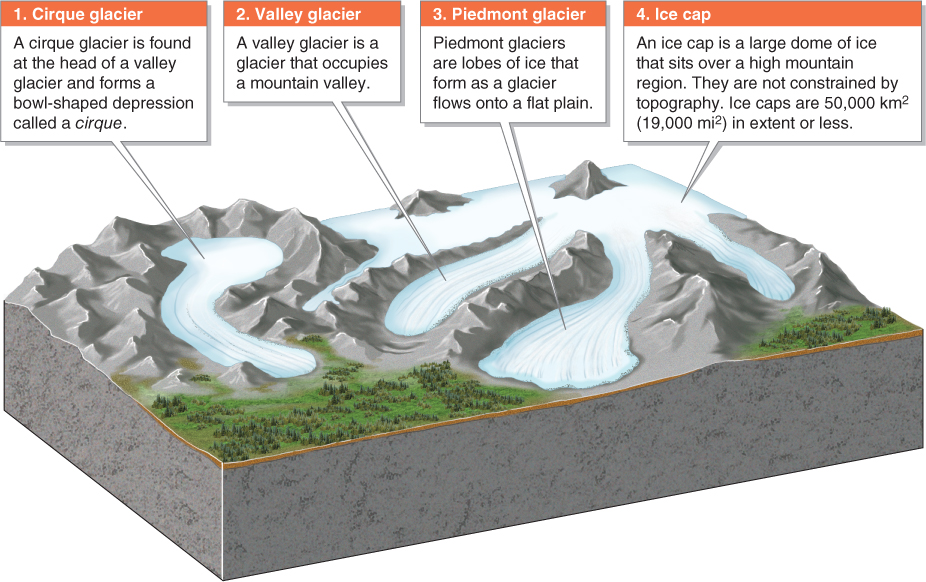
Figure 17.14
Ice sheets, in contrast to alpine glaciers, are domed sheets of ice that cover a significant portion of a continent. They are larger than 50,000 km2 (19,300 mi2). Only Greenland and Antarctica have ice sheets, and together they contain over 99% of all ice on Earth (Figure 17.15A).
ice sheet
A flat sheet of ice that has an extent of 50,000 km2 (19,300 mi2) or more.
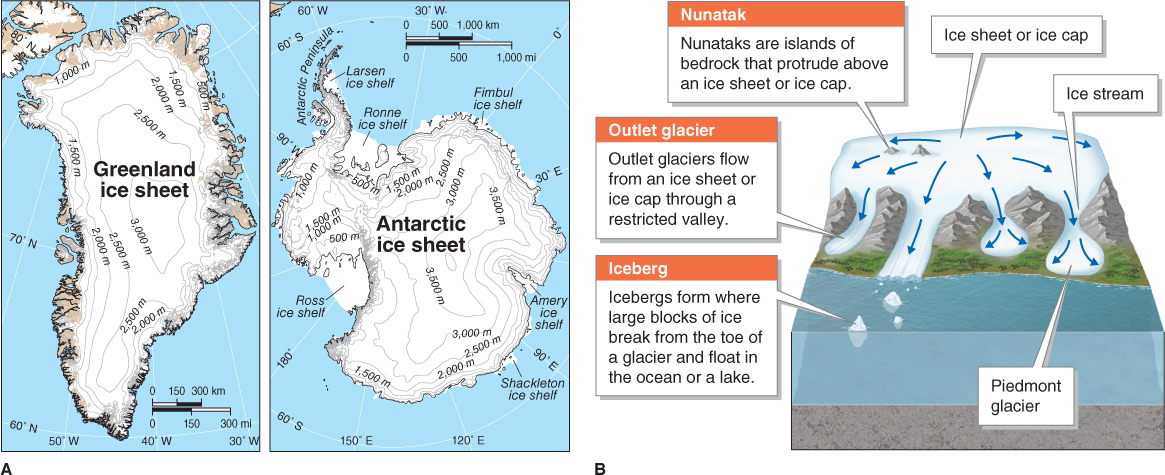
Figure 17.15
 As ice sheets and ice caps flow slowly outward from their centers, they may surround an exposed high point of land, forming a nunatak: an area of bedrock that protrudes above the glacier. Large lobes of ice at the margins form outlet glaciers and piedmont glaciers. An outlet glacier is a glacier that flows out of an ice sheet or ice cap through a constricted valley, usually into the ocean. Ice streams are areas where ice flow is accelerated, as when ice travels over steep terrain or through a constricted valley (Figure 17.15B). The Geographic Perspectives, at the end of this chapter, examines outlet glacier flow speeds in Greenland and Antarctica in the context of climate change and global sea-
nunatak
(pronounced nuh-
outlet glacier
A glacier that flows out of an ice sheet or ice cap through a constricted valley, usually into the ocean.
Icebergs
On April 15, 1912, the maiden voyage of the “unsinkable” Titanic was brought to a tragic end when it struck an iceberg in the –2°C (28°F) waters of the North Atlantic Ocean about 650 km (400 mi) south of Newfoundland, Canada. The ship sank at approximately 2:20 a.m. local time. Because of a lack of lifeboats, more than 1,500 people were forced into the frigid water and died of exposure within minutes.
An iceberg is a large block of ice that breaks from the toe of a glacier or an ice shelf and floats in open water. When glaciers reach the sea (or a lake), they calve (release) icebergs as a result of stresses caused by the tides, ice buoyancy, and melting from beneath. Glaciers that reach sea level are called tidewater glaciers. Most tidewater glaciers are found above 55 degrees north and south latitude. The lowest-
iceberg
A large block of ice that breaks from the toe of a glacier or an ice shelf and floats in the ocean or a lake.
557
Where ice sheets flow into the sea, they can form ice shelves. An ice shelf is the portion of an ice sheet or an outlet glacier that extends over the ocean. Icebergs that calve from ice shelves can be enormous (Figure 17.16).
ice shelf
The portion of an ice sheet or an outlet glacier that extends over the ocean.
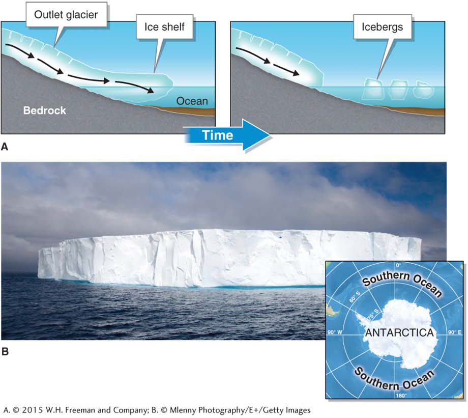
Figure 17.16