18.1 Desert Landforms and Processes
Provide examples of desert landforms and discuss the processes that form them.
We usually think of deserts as hot, sandy places. For many desert regions, that image is accurate. But some deserts are cold and rocky, and the polar deserts are covered by ice sheets. What exactly is a desert? All deserts have severe moisture deficits for most or all of the year (see Section 8.4). Generally speaking, deserts occur where less than 25 cm (10 in) of precipitation falls annually. More humid regions can also be deserts if evapotranspiration rates are high and moisture loss exceeds precipitation.
Three main factors cause aridity: (1) the subtropical high-
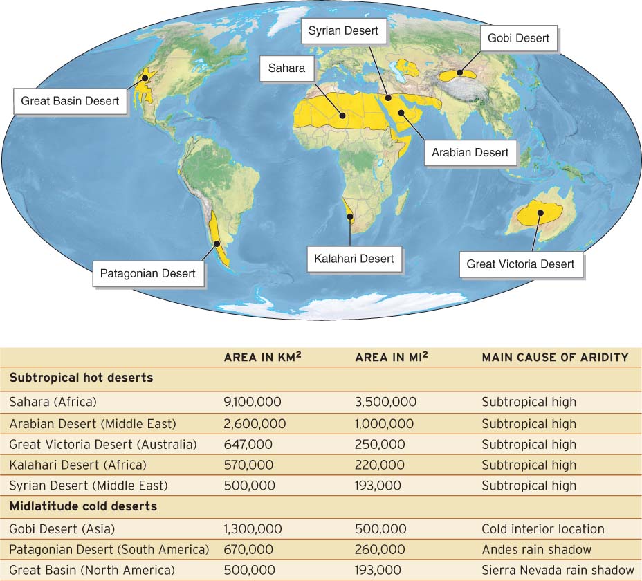
Figure 18.2
Because of their aridity, all deserts have sparse plant cover and low biomass. As a result, no other environment on Earth is as exposed to the erosive effects of flowing water and wind, save perhaps coastal areas, as we will see in Section 19.2. We explored life in the desert biome in Section 8.4. In this chapter, we focus on the processes of desert geomorphology.
582
583
Weathering in the Desert
Physical weathering is more important than chemical weathering in deserts. Chemical weathering requires the presence of water, and water is only intermittently present in deserts. Chemical weathering therefore occurs very slowly in deserts compared with more humid regions. When water from rainfall or dew enters a rock, it gradually dissolves minerals within the rock. In sandstone, for example, calcite can hold quartz grains together. Quartz resists chemical weathering, but calcite does not. When calcite is dissolved through chemical weathering, the rock disintegrates and crumbles into quartz sand granes. These grains can then be carried away by wind and water and deposited to form quartz sand dunes. Additionally, weak joints in rock cause the rock to fracture. If rocks tumble or fall down steep slopes, they are broken into smaller fragments.
The exposed surfaces of many desert rocks are covered with rock varnish: a thin, weathered, and darkened surface formed by the activities of bacteria and the accumulation of windblown clay particles. Rock varnish is a type of biochemical weathering found on rock surfaces almost exclusively in arid and semiarid climates. In more humid climates, rain washes away the clay particles too fast for rock varnish to form.
rock varnish
A thin, weathered, and darkened surface on exposed rock surfaces formed by the activities of bacteria and the accumulation of windblown clay particles.
Scratching the surface of a rock removes the thin patina of rock varnish and reveals the lighter-
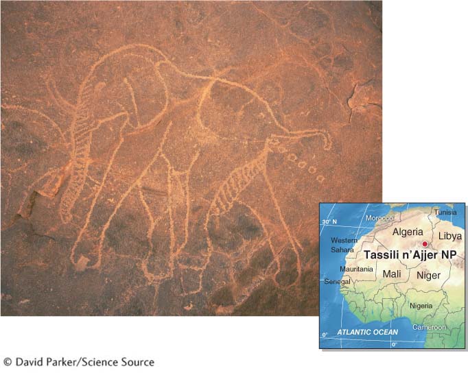
petroglyph
A prehistoric rock carving often made by scratching away rock varnish from a rock’s surface.
Picture This
The Green Sahara
Question 18.1
What are prehistoric petroglyphs and why were they made?
Petroglyphs were a part of prehistoric desert cultures worldwide. The purpose of most of them is still unknown.
This elephant petroglyph in Tassili n’Ajjer National Park, in southeastern Algeria, was made between 11,500 and 8,000 years ago, but the layer of rock varnish into which it was scratched is tens of thousands of years older. During the time when this petroglyph was made, the Sahara was much wetter. There was abundant permanent water, and large animals such as giraffes, crocodiles, elephants, hippopotamuses, and aurochs (a wild ancestor of cattle) lived throughout the region. This period is often called the “Green Sahara” because most of northern Africa consisted of savanna woodland and seasonal tropical forest. Natural climate change has since made northern Africa a desert, and these animals now live no closer than about 1,000 km (620 mi) to the south. The petroglyphs found throughout the Sahara (see also Figure GT.4) are a testament to how much northern Africa has changed in the last 8,000 years.
Consider This
Question 18.2
Uy+KVEXOrBg6+c9SPslBl8Qf41EET1a/p6ie0i53aeHj51c5h8Ztl3uwfgAE5g56Question 18.3
LrImgHy15gGqX2NQHy6dyS0x+pggJwH9UOzIJdbO3CzTUq2eg/LRWlABDKsW73f7glh0Dtj2ZlhqXgTwGZZGER1YAxtFwzj4L0aG+hd+p6bAdaZOICzLmZ0/5kdcEPSyZ6hmlQ==
The study of ancient environments such as those depicted in petroglyphs represents a line of scientific inquiry called paleoecology: the study of ancient ecosystems. Figure 18.3 explores the paleoecology of the Sahara further.
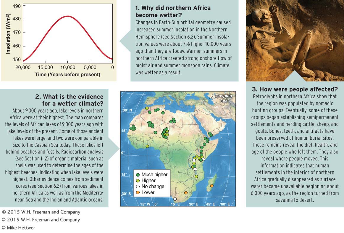
Figure 18.3
Sculpting with Wind: Aeolian Processes
Aeolian (or eolian) means “of or relating to wind.” Just as sediments are transported in a stream, aeolian erosion moves particles through traction, saltation, and suspension. The surface load of wind consists of particles moving by traction, rolling, and saltation. The suspended load consists of fine sediments of silt and clay that are suspended in the atmosphere. These particles can travel distances ranging from a few meters to thousands of kilometers as dust storms (Figure 18.4).
aeolian
(or eolian) Of or relating to wind.
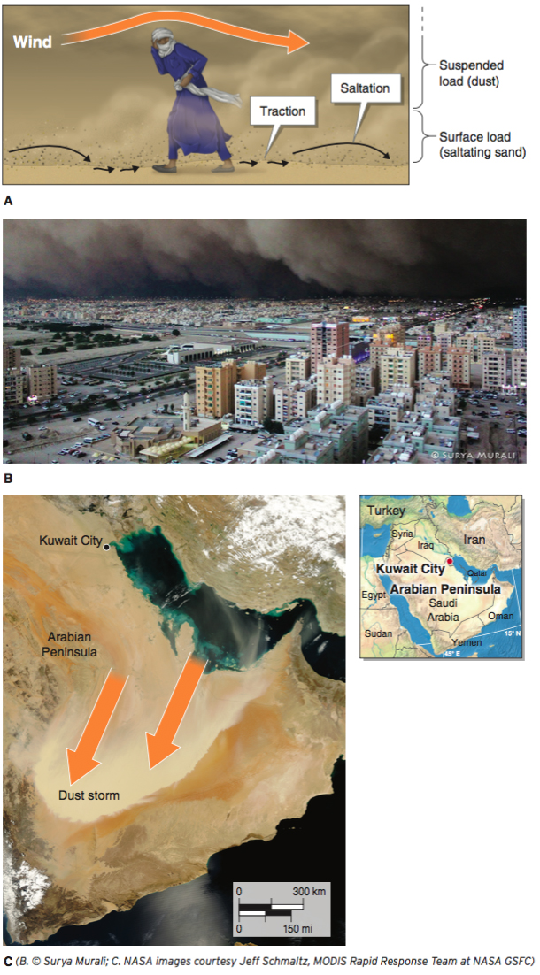
Figure 18.4
584
CRUNCH THE NUMBERS: Dust Storm Movement
CRUNCH THE NUMBERS: Dust Storm Movement
Question 18.4
FpGplrgSw+1hZJA5umkuVEyf9t/UmvyJqxH8eU+CSpfi24wR0nEaPwN6iICfhAhM7Zmbqf/GMaG7CX3zSaWgy6hZ0SVEfyPGbJMjO36qFdQU07NyQV9h82Vbu+bT5kIfTbEEaWDyIh8LMA9JFnHnlAN55OFwKstEdnYViSYe9qTO8MccwtcILFN9uSv9oaY7eagLuBQIepYs/plYHDNO6H0jBGPOGfB70VaWXLs9TQOccoZexcUdO5ijezRB6pztJ2AZ214REujN1URZqlMPdqMw4D6U3dGtQlbDNt+nTD/Lr+MG0G0LLIlDSgDOmai2lH97QijEM9aHdTXoa3JfS7L232OWjEfloJr35KFYruH4agwyJ75CC2DXrYVBuUsLzwkus4kK97OeCYwXDust storms can travel rapidly. The March 2011 dust storm shown in Figure 18.4 moved about 50 km/h (31 mph) as it crossed the Arabian Peninsula. Crunch the Numbers calculates approximately how long it took the dust storm to cross the Arabian Peninsula.
Saltating sand grains hop over the ground within the first meter (3.3 ft) or so of the ground surface, abrading and sandblasting rock surfaces they collide with and creating ventifacts. A ventifact is a wind-
ventifact
A wind-
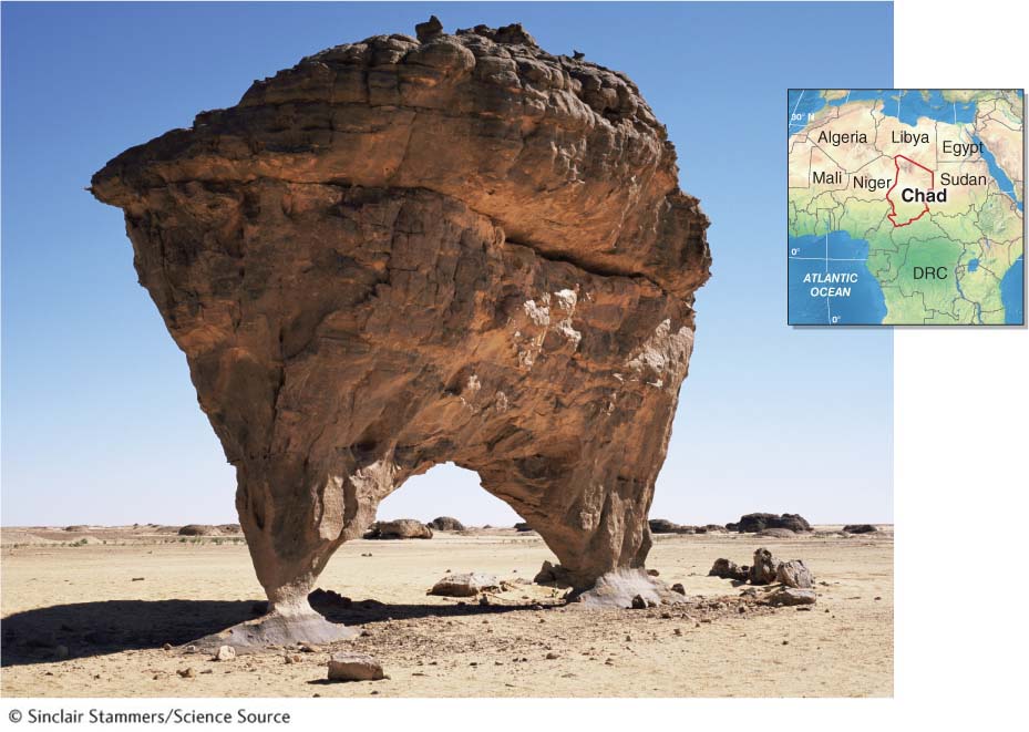
Figure 18.5
If enough fine-
deflation
The removal of sediments and lowering of the land surface by wind erosion.
Where the wind’s speed increases as it flows around an obstruction, such as a large boulder, a blowout depression may occur. A blowout depression is a bowl-
pedestal rock
A remnant of a layer of erosion-
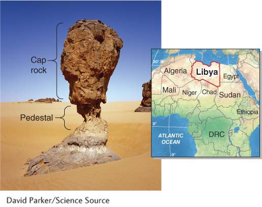
Figure 18.6
Yardangs are elongated ridges formed by deflation and sand abrasion in the desert. These ventifacts form where persistent winds move sand in the same direction for most of the year. They are generally two to three times longer than wide, and can be up to hundreds of meters high and several kilometers long (Figure 18.7).
yardang
An elongated ridge formed by deflation and sand abrasion in a desert; generally, two to three times longer than it is wide.
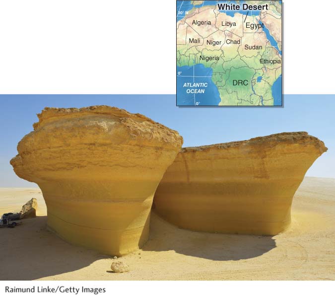
Figure 18.7
Pedestal rocks and yardangs are formed where there is net erosion by wind. The suspended material is often transported over the oceans, where it settles and slowly accumulates as sediment on the seafloor (see Section 13.3). Windblown dust from deserts plays important roles in Earth’s physical systems, as Picture This explains.
585
Picture This
Sahara Dust and Climate
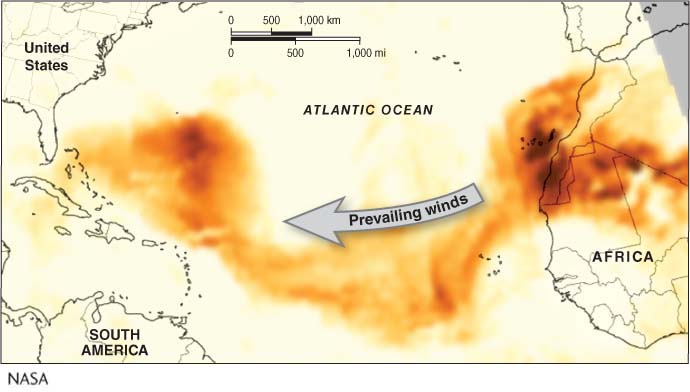
One recurrent theme in physical geography is that of interacting physical systems. A good example is the dust plumes that move from the Sahara westward on the trade winds. This image developed from satellite data shows a dust plume stretching all the way from northern Africa to Florida on July 21, 2012. The darker the orange color, the higher the concentration of suspended material in the air.
The dust from northern Africa contains iron and phosphorus. Growth of phytoplankton (see Section 10.3) in the oceans is limited by a lack of iron and phosphorus. Therefore, the dust stimulates their growth as it settles on the ocean. Similarly, the soils of the Amazon rainforest are nutrient-
Climate models do not yet agree on whether precipitation in northern Africa will increase or decrease in the coming decades as the global temperature continues to climb. If climate change brings wetter conditions to the Sahara, less dust will be suspended in the air as vegetation grows and anchors the soils. If climate change brings drier conditions, more dust will be suspended as vegetation is diminished.
Consider This
Question 18.5
5Ts6LC9Il8LC77fHS0THZGb3IAHOTBmjnkYc/xuYX20ypk9woZjHpt6myHpXKpGZp/GjbICBPia8SSgldkht3dCuaaoj9fD+w/rEHHjF7R427fwDkhd/hxX+lOJjOtVjnsf8YBCiSC2XacB6Sl1EPASbxTDQbjP2JTcWxUnyrPuDwaK4NDK6m+uQPuLyQCvGRyGLbDQ8e1frzifvtd8OVvgjhmFsgVXPOBqka6cgAgQivF7y8+E/tTCGYwQZour/K6tc4Epf/QEm2ukjsPkJWjZGJtujkiBeaefcwY7kfRvTWF4g04r+Mh8acJBD6ms1T2j+66YVQADoAMfpZ4n5WP6T9N8DA1MY7AfSEZ04zuIekt3p+rJryhPtBWY=Question 18.6
AH1QrldfjApWDLEg8DklDrpEsZj4WGsYnvo9eWj7IzkSe3i07uAhTDFfbGn+OGGJosqajlX8Rf7D3Zn+pFgb4sWxAgJKQT/mCmLzE0f2Yfwkn6bCi1+NgJSCAOxbkU3D5rh5F3VVJXhMvKH6aItpGMKZGVTlPm0DvEWBNdTtJ0gvg0vy1xbU+vQHcc6mmGSl+l1YfzS6FF/jMxWSkgWag23CkINz6avvt99uzHcXpyWi0EVupRM1iRCHt4O3OKIS
586
Sand Dunes
A sand dune is a hill or ridge formed by the accumulation of windblown sand. Only about 10% of deserts are covered by sand dunes. Where sand dunes do occur, they are prominent landforms. All sand dunes migrate in the direction of the prevailing wind, and they move across the desert floor more or less as a unit. Individual sand grains leave the windward side of the sand dune and accumulate at their angle of repose on the slip face on the leeward side of the dune. When viewed in cross section, sand dunes are composed of layers of deposited sand, creating a pattern called cross-
sand dune
A hill or ridge formed by the accumulation of windblown sand.
slip face
The leeward side of a sand dune, where sand settles at its angle of repose.
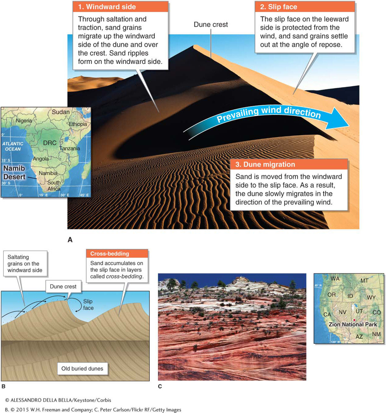
Figure 18.8
Three factors determine what kind of sand dune will form: (1) the amount of sand available, (2) the strength of the wind, and (3) whether the wind changes direction over the year. The most common types of sand dune formations are barchan dunes, star dunes, and transverse dunes. Barchan dunes are crescent-
barchan dune
(pronounced bar-
star dune
A star-
transverse dune
A long, narrow sand dune with the ridge crest perpendicular (or transverse) to the prevailing wind.
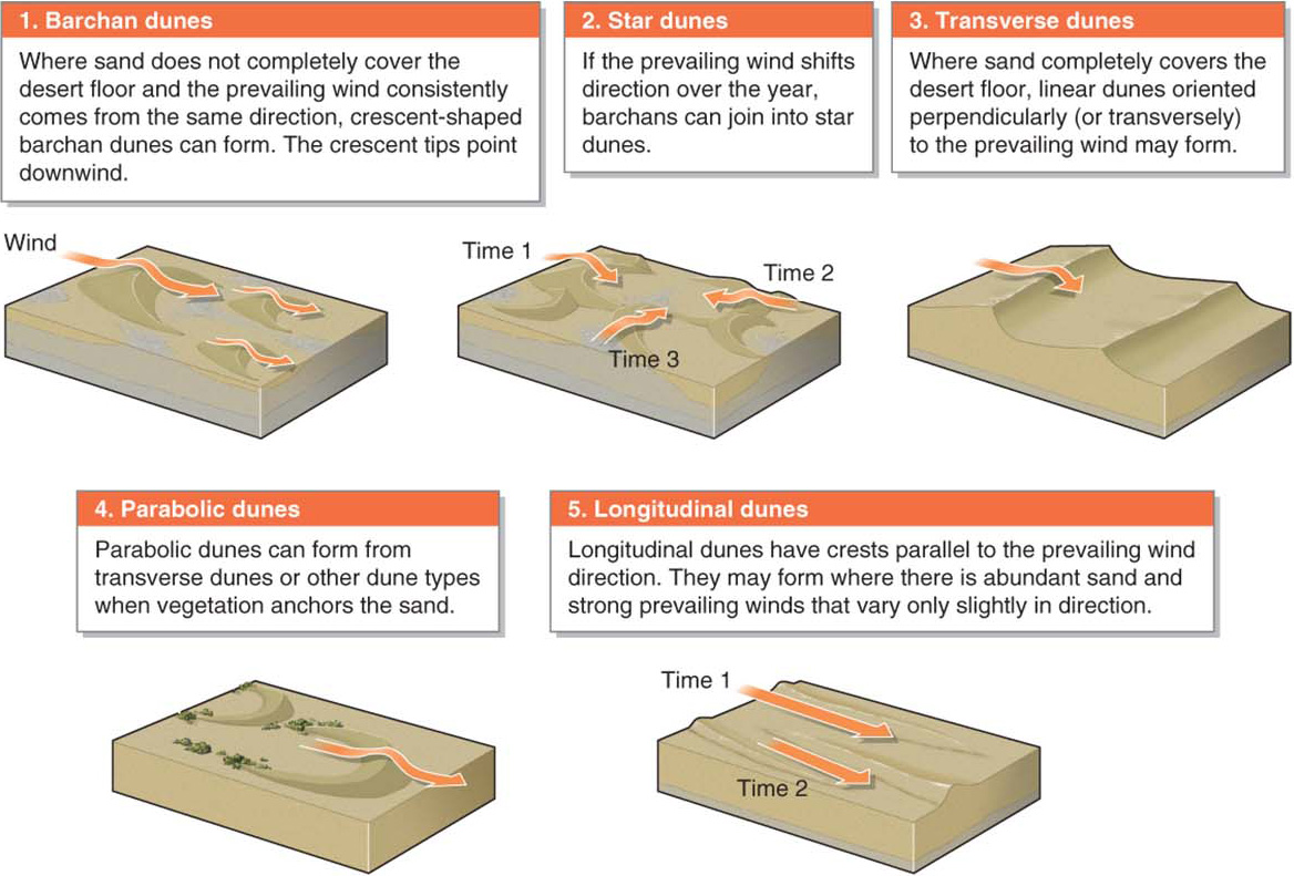
Figure 18.9
Question 18.7
How do sand dunes sing?
In some sand dunes, sand particles vibrate as they move, creating a “singing” sound.
Singing Sand
About 30 sand dune locations around the world have been observed “singing” or “booming.” As the grains of sand slide down the slip face, each grain vibrates when it encounters other grains. All together, billions of particles of sand vibrating at the same frequency can create an audible sound. The pitch of the sound depends on the size of the sand grains, their silica content, and how deep the sand dune is.
587
Desertification and Stabilizing Dunes
As we have seen, desertification is occurring in many arid regions where growing human populations put increasing pressure on already fragile semiarid environments. Arid western China has a growing problem with desertification. As human activities convert formerly vegetated regions to desert (see The Human Sphere in Chapter 4), dust storms develop and sweep eastward into populated areas.
One means of addressing desertification is to stabilize the sand so that vegetation can be reestablished. Plant roots anchor the sand and stop its movement. Where sand dunes are threatening human settlements, fences and netting can be used to slow the sand’s movement so that vegetation can be planted (Figure 18.10).
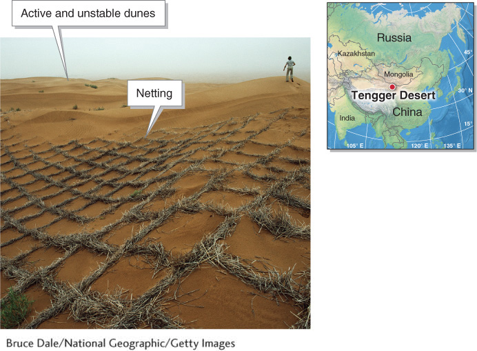
Figure 18.10
588
Sculpting with Water: Fluvial Processes
Deserts are by definition arid places, so it may seem odd that the most important agent of erosion in most desert areas is not wind, but flowing water. Deserts are particularly vulnerable to erosion by water because they have little vegetation. Plant roots anchor soil, and plants lessen the erosive effects of raindrops, sheet wash, and stream flow on the desert surface.
Fluvial Erosion
Many deserts receive summer thunderstorms and sudden flooding rains. The force of impact from raindrops dislodges particles. As water flows over the bare ground surface, these particles are picked up in the water and transported downslope. As tributaries merge, discharge increases, and streams gain erosive power. Desert streams are normally dry, but they run muddy brown from the suspended sediments they carry after thunderstorms.
Each time rainfall fills the channel of an ephemeral desert stream with water, sediments move downstream in the channel. Once the rains cease, water infiltrates the ground, and the channel goes dry again. The channel sediments will not move until the next time the channel fills with water. These ephemeral streams (see Section 16.1) go by many names, depending on the geographic locale. They are called arroyos, dry washes, or coulees in the United States. In the Middle East and northern Africa they are called wadis, in South Africa dongas, and in India they are nullahs.
Picture This
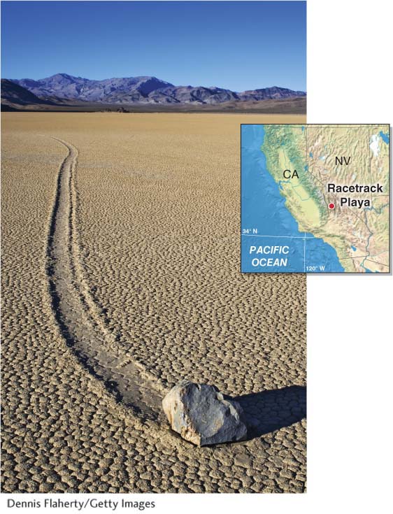
Sailing Stones
People have long known that rocks up to 300 kg (700 lb) in Death Valley’s Racetrack Playa move across the playa floor, but it was unclear how the rocks moved. No one has ever actually witnessed the rocks in the act of moving, but their long trails are indisputable evidence that they do move. Time-
Gravity is not a factor because the playa floor is almost perfectly flat. Two separate rocks may start off with parallel trails, then diverge. The sizes of the rocks do not appear to influence their rate or direction of movement. Smooth rocks tend to travel in a less straight path than sharp-
Over the years, many hypotheses have been proposed to explain these rock movements. All involve a combination of strong wind, a slippery wetted-
Consider This
Question 18.8
Dn4rMIOl8tA5s38huoKgeZwAD/uAw+uQDRwfffDmUOgbpU4c8XIJ1nPSL8kfRI9AyBFR5xCIAgHoV/EYOrqfFRI3lqvKOxjUlH6VTHcgzo6BPedvDPOqS5xIfqgB8fG5zGpY7SD6SvToGjHzXJkS1g==Question 18.9
OulPXoUgdu6TgsR9hIaUVpUxJai/lCDDp3xQBUmywIlFRo3nZSY1bJ3XCL1tZXFPxlI17/LfYUvsEKe8mwXwxYKmP/FAWjSmpewrSs/84003/8W/RkC4NplXDFc=
589
Fluvial Deposition
Where streams exit steep canyons, the stream gradient flattens out, stream velocity is reduced, and the kinetic energy of the stream is greatly reduced. As a result, the sediments carried by the stream are deposited, forming alluvial fans (see Section 16.3). Where alluvial fans emerge from adjacent valleys, they often coalesce to form a broad, sloping plain called a bajada (Figure 18.11).
bajada
(pronounced ba-
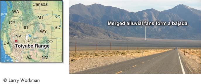
Figure 18.11
Where ephemeral desert streams empty into an internal drainage basin (see Section 16.1), they form a temporary shallow lake called a playa lake. Standing water in the playa lake typically evaporates within days to weeks. As the water evaporates, the dissolved minerals in the water form evaporite deposits as they precipitate out of the water (see Section 13.3). These deposits form a flat, dry lake bed called a playa. Playas are among the flattest and smoothest of all natural landforms on Earth. The world’s fastest cars have set land speed records on the Bonneville Salt Flats, a playa in Utah. Picture This explores an unusual phenomenon that occurs in playas.
playa lake
A shallow temporary lake that forms in an internal drainage basin.
playa
A flat, dry lake bed in a desert valley in an internal drainage basin.
 Some internal drainage basins in deserts develop saline lakes. A saline lake is a permanent body of salty water occupying a playa. Evaporation rates are high in these desert lakes, and as a result, dissolved minerals such as salt become concentrated in the water. Utah’s Great Salt Lake and the Dead Sea in the Middle East are good examples of saline lakes. At the end of this chapter, the Geographic Perspectives explores the environmental effects of human activities on saline lakes.
saline lake
A permanent body of salty water occupying a playa.