18.3 Shrinking Desert Lakes

Assess the effect of water diversions on desert lakes.
Some of the world’s largest lakes (in surface area, but not in volume) are found in deserts. Desert lakes, as we have seen, are often located in internal drainage basins and are saline. Like the mass balance of a glacier, the hydrologic balance of many desert saline lakes is at an equilibrium between water entering the lake and water leaving the lake. In other words, the lake level is a result of the amount of water flowing into the lake in streams and the amount of water leaving the lake through evaporation and infiltration.
Many large desert lakes worldwide are shrinking as people divert the streams that flow into them. This section explores three lakes that have suffered similar effects as a result of water diversions.
Asia’s Aral Sea
Question 18.11
Why has the Aral Sea nearly disappeared?
Water diversions from the rivers flowing into the Aral Sea, mainly for growing cotton, shrank the sea to 10% of its former extent.
The Aral Sea, straddling Kazakhstan and Uzbekistan in western Asia, was once the fourth largest lake in the world in surface area. In the 1960s, the rivers flowing into the Aral Sea, shown in Figure 18.22, were diverted by large irrigation canals as part of a massive Soviet project to grow cotton.
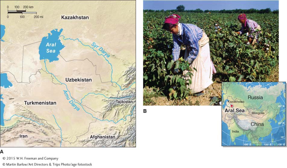
Figure 18.22
From the standpoint of producing cotton for export to global markets, the program has been a success. But without the input of water from the rivers, the Aral Sea has shrunk over time. It is now less than 10% of its original size, having become a series of shallow, briny lakes that are ecologically dead (Figure 18.23). The loss of the Aral Sea brought an end to the lucrative inland fishery that once existed there. At the peak of the harvest, more than 50,000 tons of fish were caught in the Aral Sea each year.
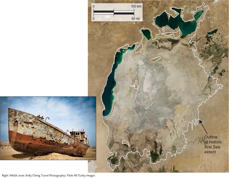
Figure 18.23
Even before the water diversions, the Amu Darya and Syr Darya carried agricultural fertilizers and sewage. As the streams emptied into the Aral Sea, this waste accumulated in the lake’s sediments. After the lake bed was exposed and dried, winds stirred up toxic dust storms that poisoned the local communities. Rates of infant mortality, cancers, and respiratory disease among local people skyrocketed. The area has the highest rates of esophageal cancer in the world. Furthermore, without the moderating effects of the lake water, the local climate has become more extreme. Winters are colder, and summers are windier and hotter.
The Loss of Owens Lake
A story similar to that of the Aral Sea can be found in North America’s Great Basin, where Owens and Mono lakes in eastern California have also suffered from water diversions.
597
598
Owens Lake was a 500 km2 (200 mi2) body of water that formed where the Owens River terminated in the lower Owens Valley (Figure 18.24). In the early 1900s, the city of Los Angeles needed water for its growing population and surreptitiously bought up land and water rights in the Owens Valley, some 266 km (165 mi) to the northeast of the city. Farmers who would not sell were coerced, sometimes under the threat of violence, to do so. Beginning in 1913, the lower Owens River was diverted to Los Angeles through a system of pipes called the Los Angeles Aqueduct, and by 1926, Owens Lake was gone.
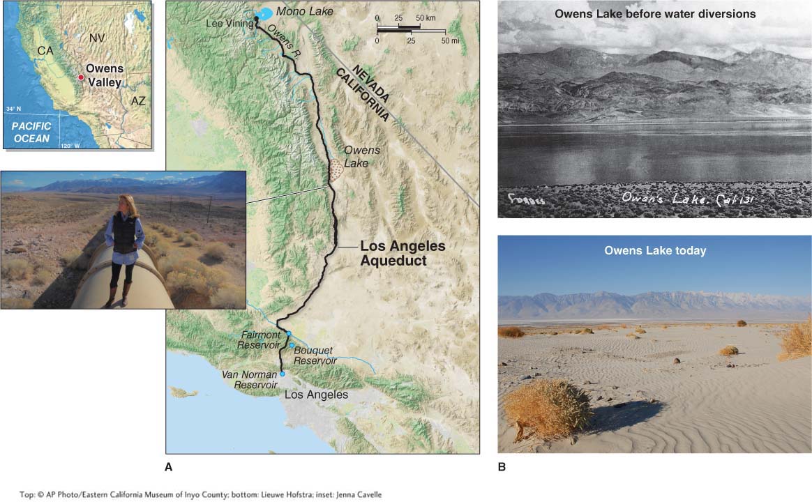
Figure 18.24
Today, Owens Valley has the dubious distinction of being the dustiest place in North America. The dust in Owens Valley’s dust storms is about 30% salt and includes the toxic elements chromium, cadmium, and arsenic. As in the case of the Aral Sea, the toxicity of the sediments arose chiefly from the use of agricultural chemicals that rivers carried into the lake and deposited on the lake bed.
599
Saving Mono Lake
Mono Lake (pronounced MOH-
During the grab for Owens Lake water rights, the city of Los Angeles also acquired land in the Mono Basin and began sending water south. As stream inflow was reduced, the level of Mono Lake began dropping. The level dropped about 15 m (50 ft) between 1940 and 1980, as shown in Figure 18.25.
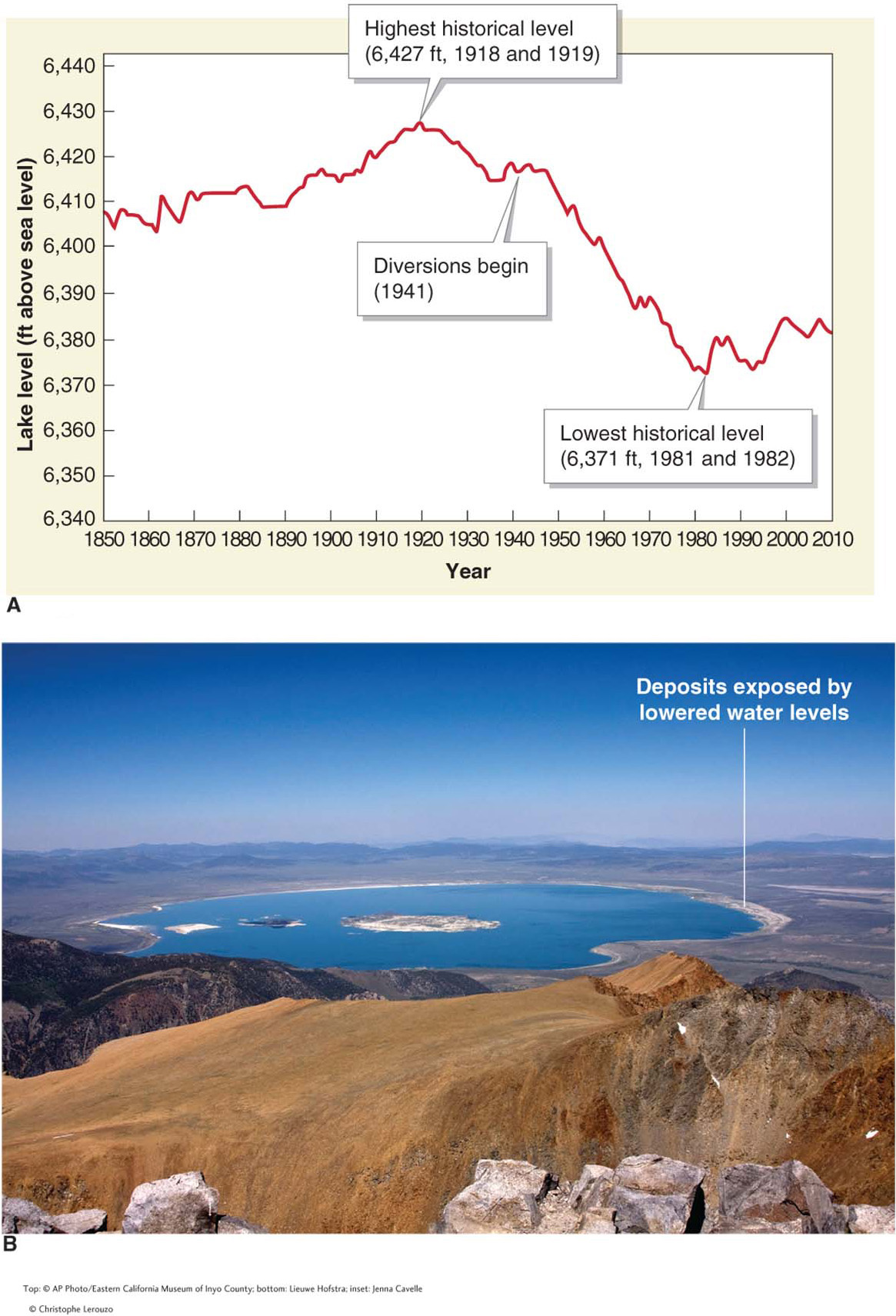
Figure 18.25
In the late 1970s, students and faculty from the University of California, Davis, started a “Save Mono Lake” campaign, and eventually, the issue of the lake’s fate was brought to court. In 1994, legislation was passed to reduce water diversions and restore water to the Mono Basin. Since that time, the lake levels have become stable and are slowly rising, but they have not returned to their pre-
Desert lakes are sensitive systems that are easily lost. Both the Aral Sea and Owens Lake were lost due to water diversions. As the case of Mono Lake shows, reversing the loss of these lakes is possible with an organized and sustained effort.
600