GT.1 Welcome to Physical Geography!
Define physical geography and explain different scales of geographic inquiry.
Have you ever wondered why deserts are barren and dry and tropical rainforests are lush and wet? Why Hawai’i has such delightfully pleasant winters but Alaska’s are brutally cold? Why there is winter and summer? How millions of tons of water can be held aloft in a thunderstorm, then fall to the ground as rain? Why tornadoes form? Whether humans are causing climate change? Why there are no polar bears in the Southern Hemisphere or penguins in the Northern Hemisphere? Why mountains form and how they are worn down? The causes of volcanoes and earthquakes? These questions all stem from a fundamental curiosity about the natural world around us. They are all questions about Earth’s physical geography, and they are all questions explored in this book.
What Is Physical Geography?
Physical geography is more than knowing the names of locations and places. Physical geography is the study of Earth’s living and nonliving physical systems and how they change naturally through space and time or are changed by human activity. A system is a set of interacting parts or processes that function as a unit. Physical geography explores how Earth’s natural physical landscapes have changed in the past and how they may change in the future.
physical geography
The study of Earth’s living and nonliving physical systems and how they change naturally through space and time or are changed by human activity.
system
A set of interacting parts or processes that function as a unit.
Physical geography is nested within the larger discipline of geography: the study of the spatial relationships among Earth’s physical and cultural features and how they develop and change through time. Geography emphasizes the role of spatial relationships between people and the physical world to gain insight into cultural and physical phenomena. Geography has several other subdisciplines. The counterpart to physical geography is human geography, which focuses on human phenomena, such as political voting patterns, human migration, transportation issues, and urban planning and development.
geography
The study of the spatial relationships among Earth’s physical and cultural features and how they develop and change through time.
Often, physical geography and human geography overlap. In this book, for example, the role of people is never far from any topic. It is difficult to find regions or systems that are not at least in part anthropogenic: created or influenced by people. People modify Earth’s physical landscapes to meet their needs, and in so doing, they are an active force of change. Earth’s surface, its atmosphere, its oceans, and its organisms have been transformed in many ways by people in just the last few hundred years (Figure GT.1).
anthropogenic
Created or influenced by people.
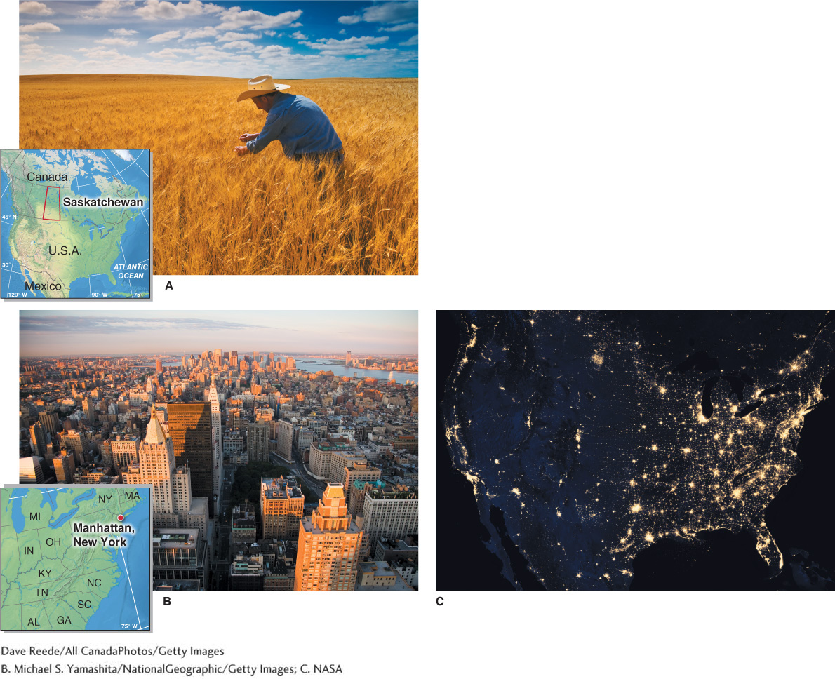
Figure GT.1
All of our material goods are connected to natural resources derived from Earth’s physical systems. The materials that meet our basic needs, such as our food, homes, cars, phones, computers, and clothing, were all once raw natural resources found in Earth’s physical systems. In growing or manufacturing these materials, people modify Earth’s natural environments.
People are also influenced by, and are a product of, Earth’s physical systems and processes. Our evolutionary history is a result of Earth’s changing land surface, ocean currents, and climate patterns. Changing climate and interactions with other organisms led to the evolution of bipedalism (walking upright) about 4 million years ago in eastern Africa. Through time, human intelligence has increased, as has our technological sophistication.
5
Physical geography explores the human transformation of Earth’s physical landscapes through science. Science is fundamental to the discipline of physical geography and to all aspects of this book. Later in this chapter, Geographic Perspectives (Section GT.5) explores the fallen civilization of Easter Island to illustrate the process of science.
 The health and well-
Scales of Inquiry
There are two types of scale that geographers often employ: spatial scale and temporal scale. Different spatial and temporal scales provide varied perspectives on physical phenomena. Spatial scale refers to the physical size, length, distance, or area of an object such as a cloud or a rainforest. Spatial scale also pertains to the physical space occupied by a process such as migration of a species or movement of sand along a coastline. (A process is a stepwise progression of events.) Temporal scale refers to the window of time used to examine phenomena and processes as well as the length of time over which they develop or change.
spatial scale
The physical size, length, distance, or area of an object or the physical space occupied by a process.
temporal scale
The window of time used to examine phenomena and processes or the length of time over which they develop or change.
6
The study of space and time underpins the study of physical geography. Together, spatial and temporal scales reveal important information about Earth’s physical systems. Using the two scales together provides a unique perspective.
Spatial Scale: Perspective in Space
Imagine your college campus or your neighborhood. You are probably thinking on a local spatial scale. On a more regional spatial scale, imagine the city where you live, or the state, or even the entire country or continent. These are all examples of different spatial scales. Thinking on local spatial scales involves more detail, such as what building a classroom is in or where a house in a neighborhood is found. On broader spatial scales, there is less local detail, but more geographic space is covered with a clearer view of the bigger picture and of context.
A map is a flat two-
map
A flat two-
large scale
A geographic scale that pertains to a geographically restricted area and makes geographic features large to show more detail.
small scale
A geographic scale that makes geographic features small to cover a large area of Earth’s surface.
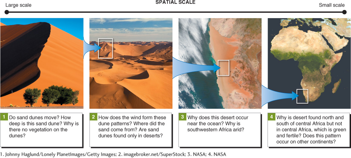
Figure GT.2
 Video
Video
Spatial scale
http:/
It is easy to know what a thing is at a large spatial scale (such as a sand dune), but seeing the small-
7
This shift in spatial scale provides a way of seeing how phenomena or processes are situated in relation to one another. Physical geography focuses on phenomena that range in size from meters to the entire planet (Figure GT.3).
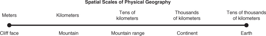
Figure GT.3
Temporal Scale: Time as a Perspective
It is difficult to see clouds moving in the sky unless you keep your eyes fixed on them. Time-
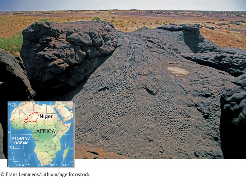
Figure GT.4
The temporal scale is particularly relevant to anthropogenic changes in Earth’s environments. Rapid changes in Brazil’s tropical rainforests, for example, have been well documented by satellite imagery through time, and that imagery has been crucial in monitoring losses of Amazon rainforest in South America. Figure GT.5 provides two different satellite images that reveal the rapid changes in the Amazon rainforest.
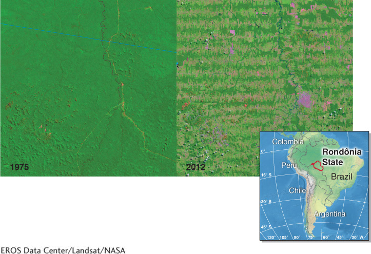
Figure GT.5
Physical geography explores phenomena and processes across temporal scales that range from minutes to millions of years. As Figure GT.6 on the next page shows, some phenomena, such as earthquakes, occur in minutes, while others, such as the development of mountain ranges, take millions of years. Some phenomena can occur over many time scales. Climate change, for example, occurs over decades to millions of years.
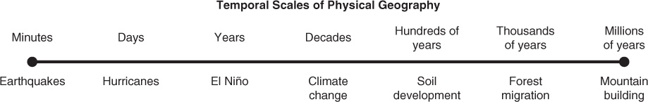
Figure GT.6
About the Metric System
You will notice as you use this book that two units of measurement are given. The metric system unit is provided first, and then the U.S. customary unit is provided in parentheses. Inches, feet, and miles are part of the U.S. customary system of weights and measurements, which also includes pounds, gallons, and degrees Fahrenheit. Centimeters, meters, and kilometers are metric system units of distance, and this system also includes kilograms, liters, and degrees Celsius.
8
The United States is the only industrialized country that still has a customary system in widespread use. The metric system is used in all formal scientific research in all countries, including the United States, and by the public in most of the rest of the world. The metric system is favored because of the ease of conversion between different units, as shown in Table GT.1.
|
10 millimeters = 1 centimeter |
|
100 centimeters = 1 meter |
|
1,000 meters = 1 kilometer |
|
1 cubic centimeter = 1 milliliter = 1 gram of water |
|
1 calorie raises 1 gram of water 1°C |
|
At sea level, water freezes at 0°C and boils at 100°C |