Earth’s topography affects the local and regional physical environment
Earth’s topography, meaning its shape and surface features, has been formed over geological time and provides the basis for much of the variation in local and regional physical conditions. Here we consider how topography modifies the physical environment with respect to land, oceans, rivers, and lakes.
1149
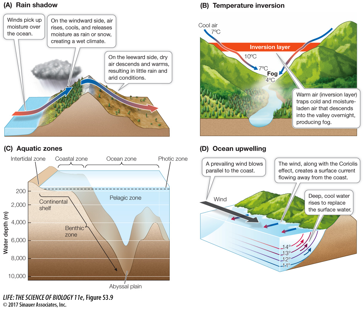
LAND The topography of land plays a large role in the regional and local physical environment, including climate. Mountains create elevational gradients in temperature, precipitation and sunlight. For example, mountains show progressively colder temperatures and greater precipitation at higher elevations, creating different environmental conditions over relatively short distances. When a mountain range occurs adjacent to an ocean, a rain shadow is often created, where one side of the mountain has a wet climate and the other side has a dry climate (Figure 53.9A). Rain shadows occur when winds deliver moist air evaporated from the ocean to the windward side of the mountain, where the air rises, cools, and releases rain or snow. On the leeward side of the mountain (that is, opposite from the direction of the winds), the now-
Question
Q: What kind of weather conditions would you expect to produce temperature inversions? How about ocean upwelling?
Temperature inversions occur when there are large temperature extremes that produce afternoon heat and morning cold. A valley concentrates heat from the sun during the day, and as the heat rises, it forms a layer of warm air (an inversion layer). The inversion layer traps cold, dense, and moisture-
Upwelling occurs when prevailing winds blow parallel to the coastline, displacing surface water away from the shoreline and thus allowing deep, cold water to rise to the surface. This cold water can cool moist air on the coast, creating morning fog.
Animation 53.2 Rain Shadow
www.Life11e.com/
Other topographic features, such as canyons and valleys, also modify local climate in significant ways. Valleys can experience temperature inversions, extremes in temperature that produce morning fog and intense afternoon heat. Temperature inversions occur when the valley concentrates heat from solar radiation during the day. As that heat rises, it forms an inversion layer that traps cold, dense, and moisture-
OCEANS Beneath the oceans, which make up 70 percent of Earth’s surface, dramatic differences in topography influence the marine environment. If you could drain the oceans, you would notice major differences in topography, ranging from the Hawaiian island Mauna Loa, the tallest “mountain” on Earth at 9,170 meters high from base to peak, to the Marianas Trench, the deepest “valley” at 10,994 meters deep. Variations in water depth affect light penetration, water temperature, water pressure, and water movement (i.e., waves and tides). These physical discontinuities create distinct zones that are identified principally by their physical conditions and the characteristic biota they contain, similar to biomes on land (see Key Concept 53.4). The depth of an ocean basin varies from the shoreline to the relatively shallow continental shelf and to the deepest part of the ocean, sometimes known as the abyssal plain (Figure 53.9C). Water depth affects how much light is available to sustain the photosynthetic organisms that form the base of the marine food chain. In both marine and freshwater environments, roughly 90 percent of all aquatic life is found in the photic zone, the layer of water reached by enough sunlight to support photosynthesis.
1150
Other zones that vary in environmental conditions include the coastal zone, which extends from the shoreline to the edge of the continental shelf, and the ocean zone, which extends beyond the coastal zone (see Figure 53.9C). The coastal zone is diverse and highly productive, supporting high densities of pelagic, or floating, plankton and fish. On the benthic or bottom of the ocean, the coastal zone has a variety of living and nonliving habitats such as rocky reefs, soft sediment flats, coral reefs, and kelp beds. The portion of the benthic coastal zone lying between the high and low tide levels is the intertidal zone, where tidal movements create conditions of highly variable light and temperature, alternately exposing organisms to air and water. Intertidal zones can occur on the open coast as sandy or rocky beaches, or in more protected bays as estuaries. Estuaries form where rivers meet the sea, creating variability in salinity, sediment, and light conditions.
In some coastal zones, where the continental shelf is steep and prevailing winds are parallel to the coastline, upwelling can affect ocean and climate conditions. Upwelling is a process in which offshore winds in combination with the Coriolis effect push warmer surface waters away from the shore, allowing deeper, colder, and nutrient-
As we move away from the coastline, most of the ocean’s physical environment is made up of vast amounts of water that is, with the exception of the photic zone (which can extend to 200 meters in some regions), mostly dark, cold, and under tremendous pressure from the weight of the water above. Little photosynthesis can take place, and many of the organisms inhabiting these regions subsist on decaying organic matter that sinks down from the photic zone. Deep-
RIVERS AND LAKES In contrast to the vast oceans, freshwater lakes and rivers make up less than 3 percent of Earth’s surface, but they are home to about 10 percent of all aquatic species. Earth’s topography influences freshwater environments just as it does in the oceans—
The Amazon River, mentioned in the chapter opening, offers a dramatic example of river dynamics. The Amazon is one of the longest rivers on Earth, at approximately 7,000 km. Eventually this source water reaches the Atlantic Ocean, where discharge is the largest of any river on Earth–