The Portuguese Overseas Empire
For centuries, Portugal was a small, poor nation on the margins of European life. The principal activities of its inhabitants were fishing and subsistence farming. Yet Portugal had a long history of seafaring and navigation. Blocked from access to western Europe by Spain, the Portuguese turned to the Atlantic and North Africa, whose waters they knew better than other Europeans. Nature favored the Portuguese: winds blowing along their coast offered passage to Africa, its Atlantic islands, and ultimately Brazil.
In the early phases of Portuguese exploration, Prince Henry (1394–
The objectives of Portuguese exploration policy included military glory; the conversion of Muslims; and a quest to find gold, slaves, and an overseas route to the spice markets of India. Portugal’s conquest of Ceuta, an Arab city in northern Morocco, in 1415 marked the beginning of European overseas expansion. In the 1420s, under Henry’s direction, the Portuguese began to settle the Atlantic islands of Madeira (ca. 1420) and the Azores (1427). In 1443, they founded their first African commercial settlement at Arguin in North Africa. By the time of Henry’s death in 1460, his support for exploration was vindicated by thriving sugar plantations on the Atlantic islands, the first arrival of enslaved Africans in Portugal, and new access to African gold.
The Portuguese next established trading posts and forts on the gold-
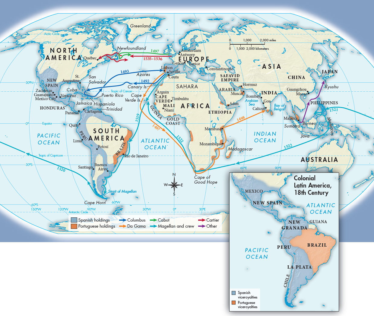
CONNECTIONS: How would you compare Spanish and Portuguese New World holdings in the sixteenth century with those of the eighteenth century? How would you explain the differences and continuities over time?
The Portuguese then pushed farther south down the west coast of Africa. In 1487, Bartholomew Diaz rounded the Cape of Good Hope at the southern tip, but storms and a threatened mutiny forced him to turn back. A decade later, Vasco da Gama succeeded in rounding the Cape, and, with the help of an Indian guide, he reached the port of Calicut in India. Overcoming local hostility, he returned to Lisbon loaded with spices and samples of Indian cloth. Thereafter, a Portuguese convoy set out for passage around the Cape every March.
Lisbon became the entrance port for Asian goods into Europe, but this was not accomplished without a fight. Muslim-
In March 1493, between the voyages of Diaz and da Gama, Spanish ships under a Genoese mariner named Christopher Columbus (1451–