6.1 The hydrologic cycle moves water around Earth
158
6.1–
Imagine you are visiting Earth from a distant planet. As you approach, you see a blue world covered mostly by vast oceans and enveloped by clouds of water vapor. The continents are dotted by lakes and ponds and laced with rivers and streams. You also see extensive areas near the poles covered by snow and ice. If you had ground-
hydrologic cycle The movement of Earth’s water between the oceans, atmosphere, and terrestrial and freshwater environments.
Pick a single drop of water and follow it from a mountainside spring down a freshwater river and into the salty ocean. Warmed by the Sun, this drop of water evaporates and its molecules rise high into the atmosphere, where they can fall to Earth again in the form of rain or snow. The process by which Earth’s water moves among the oceans, atmosphere, terrestrial and freshwater environments, and back to the ocean is called the hydrologic cycle. This is one of the most critical of Earth’s natural processes because it sets limits within which we must work to sustain supplies of freshwater.
The Distribution of Earth’s Water
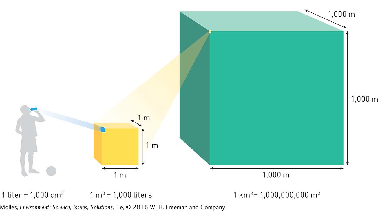
The amount of water cycling through Earth is so vast that we can’t talk about it in terms of liters or gallons. The typical unit of volume at this scale is the cubic kilometer (km3) which is equal to 1 trillion liters (Figure 6.1). If it were spread out, 1 km3 of water would form a band of water 1 meter deep and 25 meters wide that would completely encircle Earth at the equator. From a human perspective, this is an immense quantity of water, yet it is tiny in comparison to the water flowing through the hydrologic cycle. The total amount of liquid freshwater on Earth’s surface and in the ground amounts to more than 10 million km3. When you add all the water in the atmosphere, oceans, and ice caps, we are talking about a total of 1.4 billion km3.
159
reservoir A body of water, ranging in size from a pond to an ocean, including below-
groundwater Water found in the pore spaces in rock and sediments beneath Earth’s surface; feeds wells, springs, and desert oases, and is Earth’s second largest reservoir of freshwater.
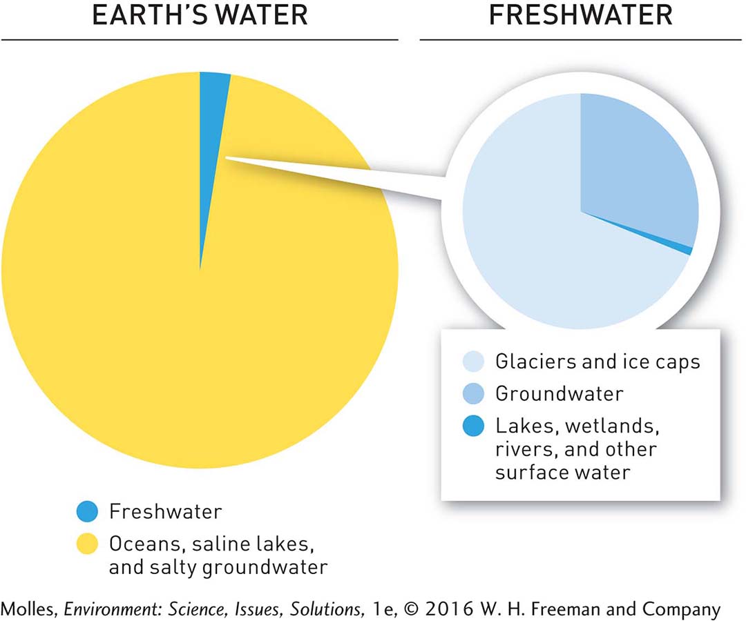
Earth’s water resides in pools called reservoirs. The atmosphere, oceans, lakes, rivers, soils, glaciers, snowfields, and groundwater are Earth’s main reservoirs of water. The oceans make up the largest of Earth’s water reservoirs, containing nearly 97% of all Earth’s water. All of the water in the oceanic reservoir is, of course, saltwater. The largest freshwater reservoir, containing over two-
aquifer A geologic formation containing groundwater; gains water through the process of infiltration and loses water through groundwater flow.
water table The uppermost level of groundwater, which forms the boundary between the saturated and unsaturated zones.
saturated zone The layers of rock below the water table, in which the pore spaces in the geologic formation are saturated with water.
unsaturated zone The layers above the water table, which are not saturated with water.
runoff The amount of water falling as precipitation that flows off the land as surface and subsurface flow.
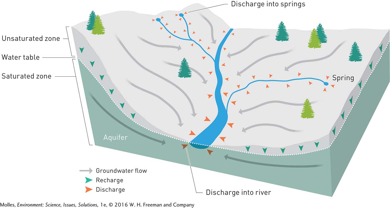
A geologic formation containing a deposit of groundwater is called an aquifer. The amount of water present in an aquifer results from the balance of water flowing in via infiltration and draining out through groundwater flow. The water table is the uppermost level of the groundwater, forming the boundary between the groundwater and overlying soil or rock. The layers of rock below the water table, in which the pore spaces in the geologic formation are saturated with groundwater, are called the saturated zone; the layers above the water table, which are not saturated with water, are referred to as the unsaturated zone. Groundwater gets recharged as water from rain or melting snow infiltrates the ground, descends under the force of gravity, and eventually flows to the water table. The rate of groundwater recharge depends on the amount of precipitation, rate of evaporation, and permeability of the soil and rock. Infiltration rates are higher through coarse-
When the soil is topped with leaf litter and other organic matter, as well as broken up by tree roots and the burrows of animals such as earthworms, there will be a significant amount of infiltration. However, in areas with few plants and animals, precipitation rates can easily exceed rates of infiltration, resulting in high amounts of runoff. One example of this is the desert, where flash floods are common during infrequent but intense storms.

Would the water deposited by precipitation move differently through an urban environment than through a temperate forest environment? How and why?
discharge In an aquifer, the movement of water from the groundwater to a body of surface water (e.g., a river or lake).
Groundwater flows from areas of recharge to areas of groundwater discharge, such as rivers, lakes, and springs, or directly into oceans. Aquifers made up of coarse, sandy materials generally support higher groundwater flow rates. The time required for groundwater to flow from recharge to discharge areas can range from days to thousands of years, depending on flow rates and the distance traveled (Figure 6.3).
watershed (catchment) The area of land that collects water, which falls as precipitation and flows into an aquifer or river system.
A watershed, or catchment, is the area of land collecting water, falling as precipitation, that flows into an aquifer or a river system. For instance, the Mississippi River watershed is the fourth largest in the world, and it includes parts of 31 states and 2 Canadian provinces. The surface water in this watershed eventually passes through the Mississippi Delta and into the Gulf of Mexico.
Water Moves Among Reservoirs
flux The rate of flow of materials or energy across a given area (e.g., the flow of water vapor from the ocean’s surface to the atmosphere or the flow of radiant energy between an organism and its surroundings).
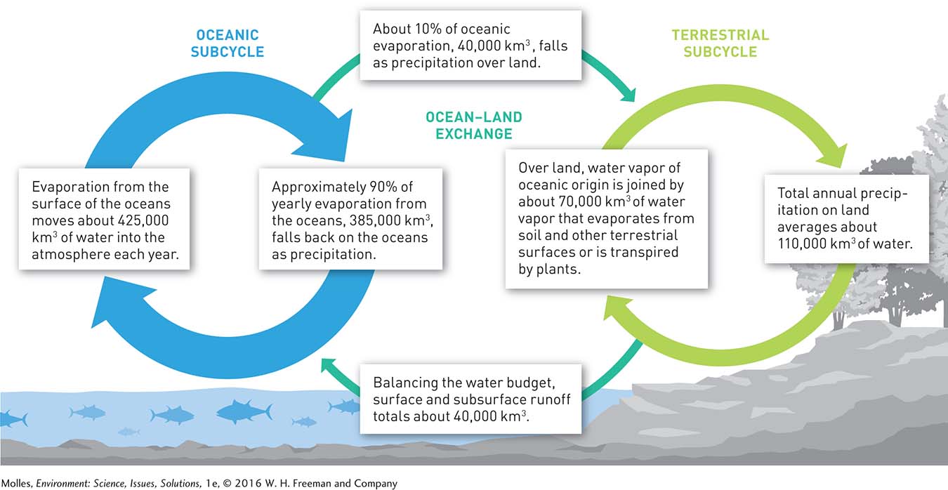
Water moves from one reservoir to another through processes such as precipitation, evaporation, and runoff. This flux of water among reservoirs, which is the basis of the hydrologic cycle (Figure 6.4), is powered by the Sun, which causes water to evaporate. As water vapor rises into the atmosphere, it cools and condenses, forming clouds. Much of the snow and rain on land originates from the evaporation of moisture from soils and from the loss of water from trees and other plants. More than one-
160
Is the movement of water through the hydrologic cycle influenced by physical processes only? Explain.
Think About It
How does Figure 6.4 explain why the 40,000 km3 of annual runoff is our renewable freshwater supply, which is a far smaller amount than the total volume of freshwater in groundwater, lakes, rivers, and streams?
How many liters of water per person does annual runoff equate to, assuming a global population of 7 billion?
Why is the number you calculated in response to Question 2 not a practical indicator of the amount of water available to human populations?
Can we treat groundwater and surface water as separate resources and manage water sustainably?