8.2 Nutrient availability influences primary production in marine environments
232
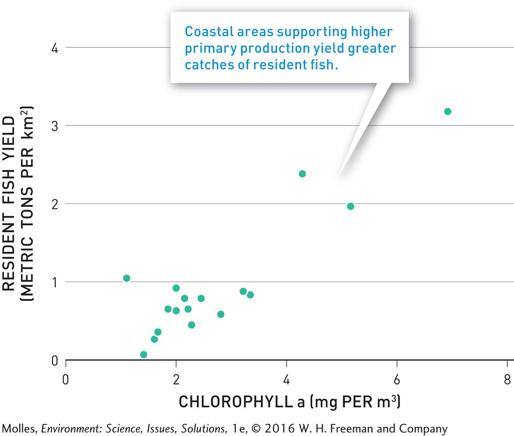
The large fish we prize in the developed world, such as cod, salmon, and tuna, are usually apex predators that feed at or near the top of the food web. These fish and all other consumers in the food web would not exist without organisms at the bottom of the food web that convert solar energy into the chemical energy of sugars. The photosynthetic organisms of the oceans—
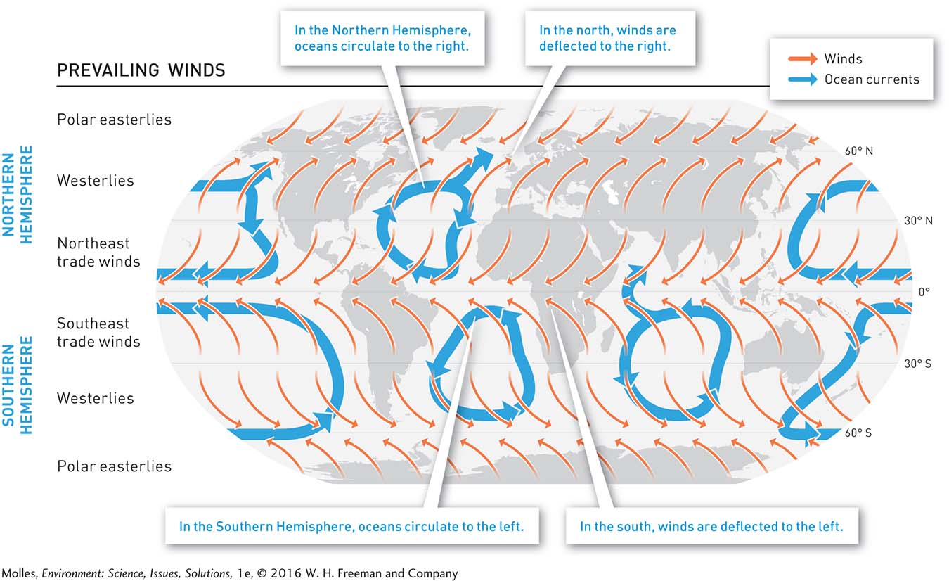
prevailing winds Winds that blow consistently from one direction (e.g., the northeast trade winds blow from the northeast).
Coriolis effect A deflection in the winds from a straight north–
As wind blows across the surface of the ocean, it pushes and pulls water, creating ocean currents and influencing the nutrients available to fish stocks. On Earth, we have prevailing winds that blow consistently from one direction, but they do not end up moving directly north or south. Rather, the rotation of Earth creates a deflection in the winds called the Coriolis effect, which deflects winds to the right in the Northern Hemisphere and to the left in the Southern Hemisphere. The result is the global pattern of prevailing winds: northeast trade winds, westerlies, and polar easterlies in the Northern Hemisphere; southeast trade winds, westerlies, and polar easterlies in the Southern Hemisphere (Figure 8.2). As the prevailing winds blow across the oceans, they set in motion oceanic currents. The Coriolis effect acts on these currents to create large-

In March 2011 a tsunami washed massive amounts of debris, including entire houses, into the Pacific Ocean off Japan’s east coast. Explain why several months later that debris began washing up on the western shores of North America.
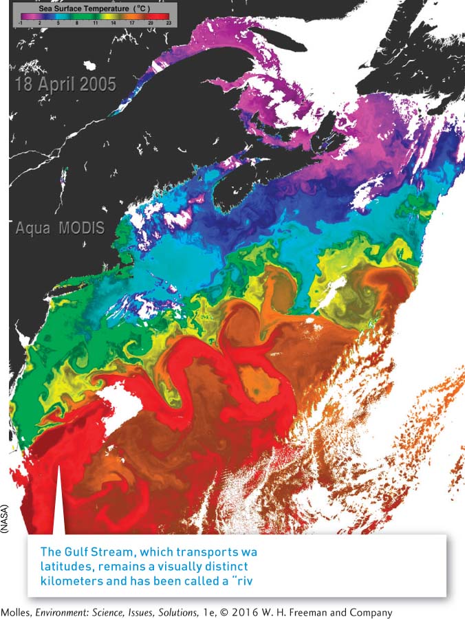
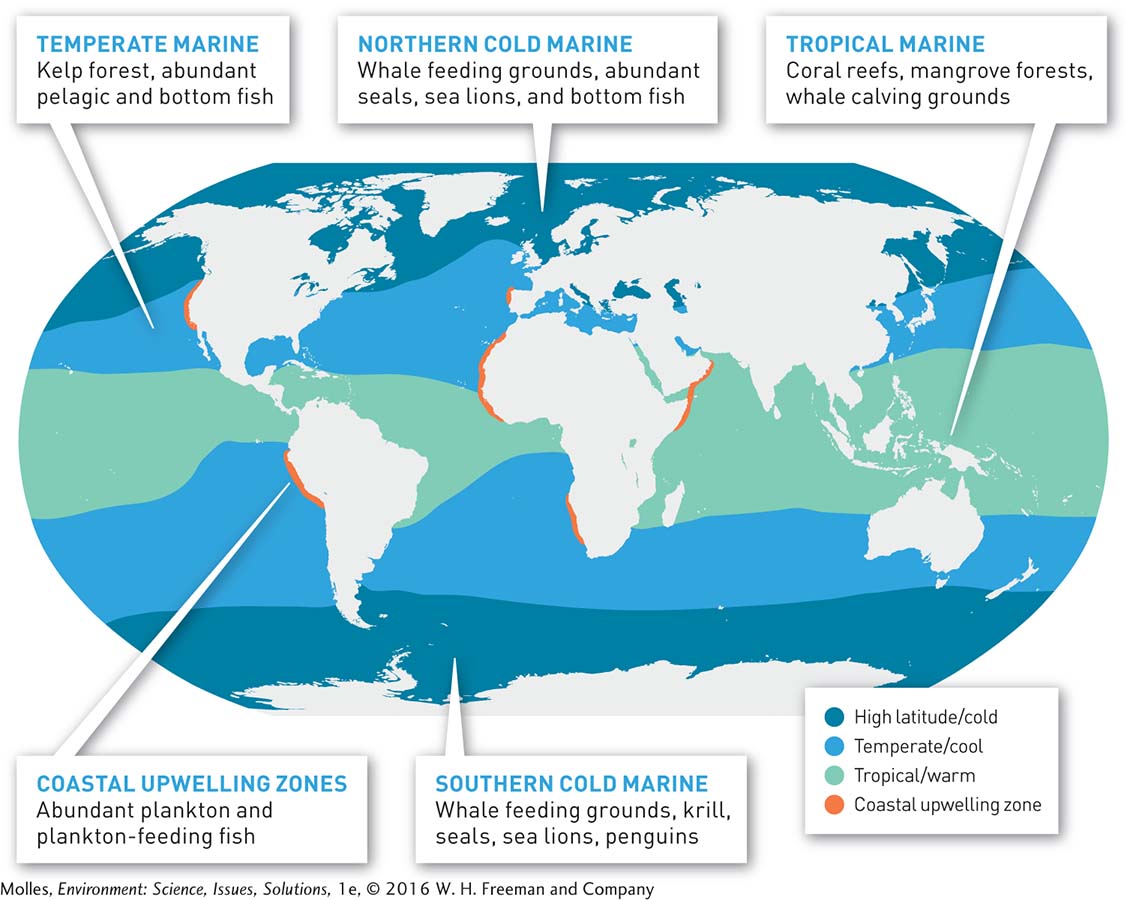
Oceanic currents exert major influences on regional climates by transporting heat or, in some situations, cooling waters from one region to another. The Gulf Stream in the Atlantic Ocean, for instance, transports heat from the tropics to higher latitudes, extending temperate climates much farther north in northwest Europe than would be the case otherwise (Figure 8.3). Meanwhile, the Labrador Current in the western Atlantic Ocean cools northeastern North America. The currents also modify the distribution of marine environments (Figure 8.4). For example, the currents extend cool marine waters northward along the southwest coast of Africa and southward along Africa’s northwest coast. This transport of cool surface waters significantly narrows the band of warm, tropical marine waters in the eastern Atlantic Ocean, compared with the western Atlantic.
233
Light, Nutrients, and Primary Production
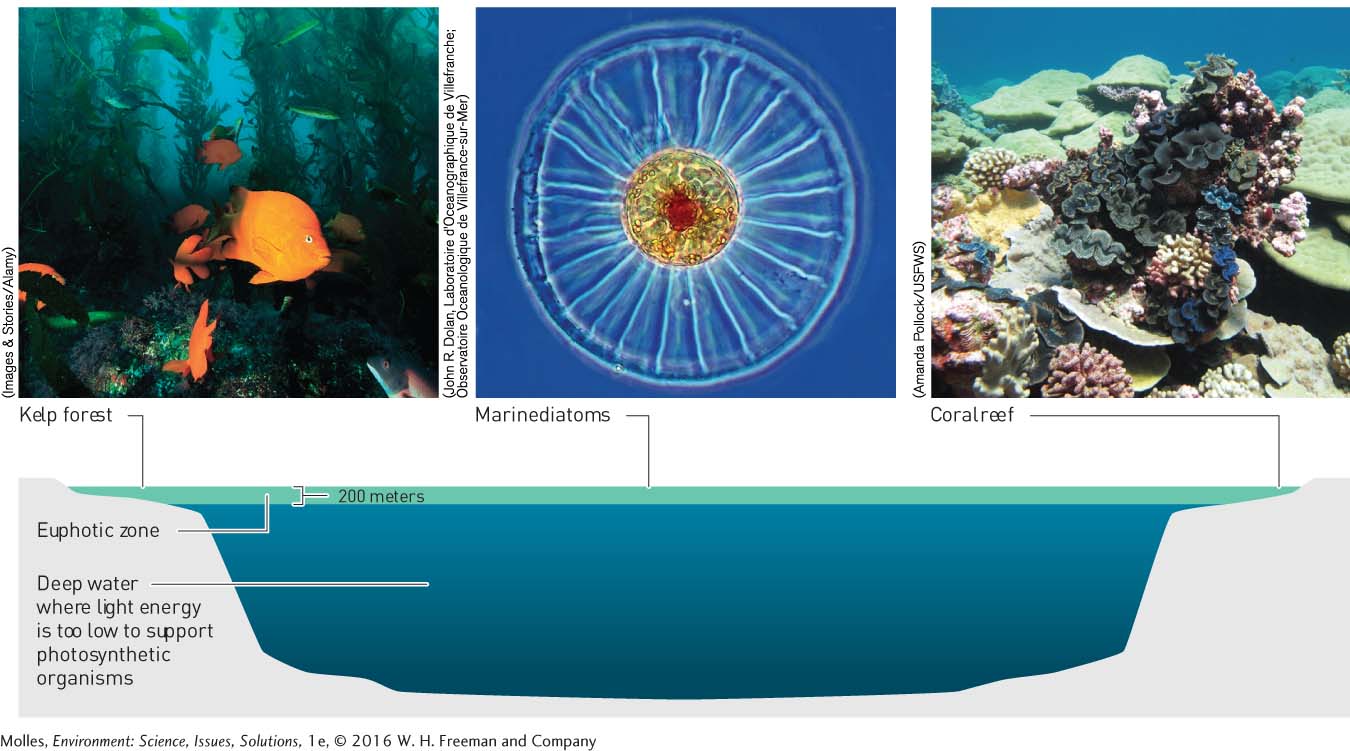
euphotic zone A surface layer of the oceans and deep lakes where there is sufficient light to support photosynthetic aquatic organisms.
Although light penetrates water, it grows weaker with depth, extending to a maximum depth of 200 meters and restricting photosynthesis to a surface layer of the oceans and lakes known as the euphotic zone (Figure 8.5). As organic matter produced in the euphotic zone sinks through the water column, it carries with it various elements essential for photosynthesis, such as nitrogen, phosphorus, and iron. Warmer surface layers are less dense than deeper layers, which means there is little vertical mixing with deeper cool water. As a consequence, essential chemical nutrients depleted from warm surface waters build up in deeper cool-
234
upwelling The movement of cold subsurface water to the ocean’s surface when warmer surface waters move offshore under the influence of prevailing or seasonal winds.
The process of upwelling does just that. Driven by prevailing or seasonal winds, upwelling generally occurs where winds blow warmer surface water away from shore and replace it with colder, subsurface water. As shown in Figure 8.2, extensive areas of upwelling occur along the west coasts of North and South America, North and South Africa, southwestern Europe, and along shores of the northwest Indian Ocean, where upwelling is driven by seasonal monsoon winds.
The Phosphorus Cycle
ATP (adenosine triphosphate) An energy-
Phosphorus is one of the critical elements that can be brought to the surface via upwelling. While the nitrogen and carbon cycles include a major atmospheric reservoir, another critical biogeochemical cycle—
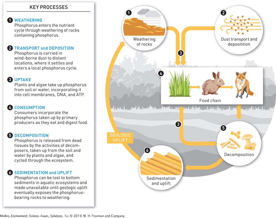
When a fish dies and is incorporated into marine sediment, that sediment often ultimately becomes a rock that integrates phosphorus into a mineral, closing the cycle. Other minerals in the ecosystem that, like phosphorus, do not have gaseous forms either (e.g., iron, potassium) undergo similar cycles, with only minor variations in some of the details.
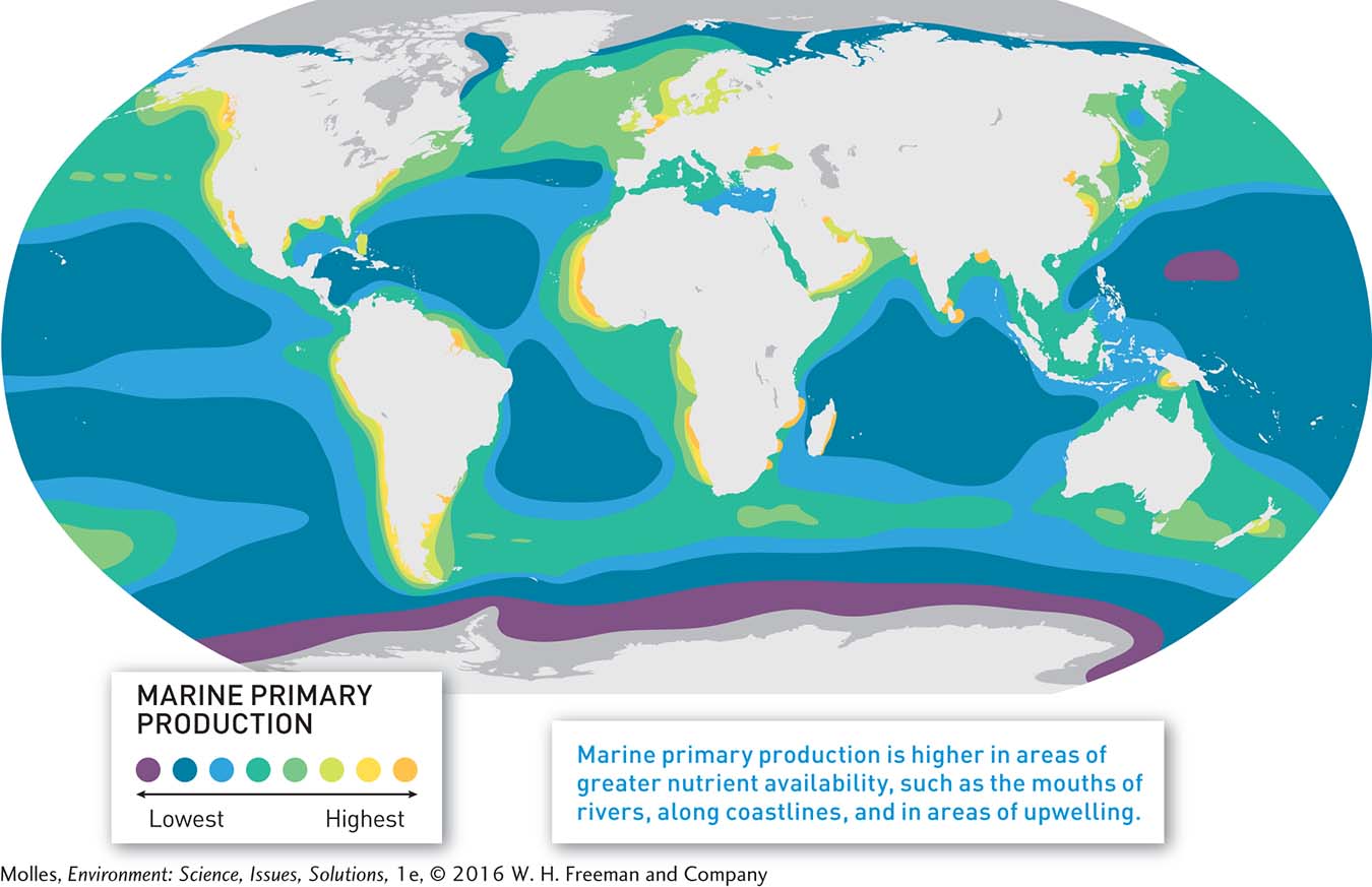
Global Patterns in Production
The highest levels of marine primary production lie along the margins of the continents, especially where upwelling brings nitrogen and phosphorus-
235
236
Why are so many of the world’s very productive fishing grounds found in cool upwelling waters?
The lowest levels of primary production tend to occur in deep, mid-
Think About It
How do surface winds influence global patterns of primary production in the ocean?
What processes tend to reduce the concentrations of nutrients essential for marine production from the euphotic zone of the oceans?
How does upwelling increase the nutrient content of surface waters?
How would you expect marine primary production to respond if changing environmental conditions caused widespread extinctions of marine phytoplankton species?