Central China
Central China consists of the upper, middle, and lower portions of the Chang Jiang (Yangtze River) basin (Figure 9.35). Like many of Eurasia’s rivers, the Chang Jiang starts in the Plateau of Tibet. It descends to skirt the south of Sichuan Province, then flows through the Witch Mountains (Wu Shan) and the Three Gorges Dam, leaving the upper basin and flowing into the middle basin in China’s densely occupied central plain. It then winds through the coastal plain (the lower basin) and enters the Pacific Ocean in a huge delta, the site of the famous trading city of Shanghai.
Sichuan Province
Sichuan, with 108 million people, has some of China’s richest resources: fertile soil, a hospitable climate, inventive cultivators, and sufficient natural raw materials to support diversified industries. For years, Sichuan embodied the ideal of complementary agricultural and industrial sectors, but it could not keep pace with the coastal industries that attracted its young people. Now, old industrial cities like Chongqing are changing and are successfully recruiting foreign investors to enhance their competitive edge.
The heart of the province is the Sichuan Basin, also called the Red Basin because of its underlying red sandstone. It is a region of hills and plains crossed by many rivers that drain south toward the Chang Jiang. The basin is on a south-facing slope and is surrounded by mountains that are highest in the north and west, forming a barrier against the arctic blasts of winter and trapping the moist, warm air that moves up from the southeast. For these reasons, the Sichuan climate is generally mild and humid, and the basin is so often cloaked in fog or low cloud cover that it is said, “A Sichuan dog will bark at the sun.”
519
Over thousands of years, Sichuan’s relatively affluent farmers have cleared the native forests and manicured the landscape, so that only a few patches of old-growth forest are left in the uplands and mountains. The rivers have been channeled into an intricate system of irrigation streams for wet rice cultivation and, more recently, for growing the fine vegetables and fruits that affluent urban dwellers across China want.
The population density of Sichuan is more than 800 people per square mile (300 per square kilometer). Most of the people are farmers, growing rice, wheat, and corn, and as a sideline, raising animals such as silkworms, pigs, and poultry. In the new market economy, it is often these sidelines that earn them the most cash income. In the mountain pastures to the west of the basin, Tibetan herders raise cattle, yaks, sheep, and horses. (Sichuan has the largest population of Tibetans outside Tibet—close to 1 million.)
The two main cities of the Sichuan Basin are Chengdu, the provincial capital (with a population of 14 million in the metropolitan area), and Chongqing (with a population of 29 million in its larger metropolitan area). Chengdu is a transportation hub and is home to light industries, especially food processing and textile and precision instrument manufacturing. Some of its higher-quality products are sold in the global market. Chongqing, with its thousands of iron and steel manufacturers and machine-building industries, is an old industrial city now in decline, but it is being targeted for renewal as Sichuan attempts to attract workers back to the interior from the coastal provinces. As a result of the construction of the Three Gorges Dam, Chongqing, which lies at the western end of the dam reservoir, is also in line to become a hub for shipping and other new economic activities, especially as it benefits from an abundance of electricity from the Three Gorges Dam.
520
Sichuan’s productivity and dense population has resulted in the degradation of its environment. The basin tends to be subject to temperature inversions—when the ground cools down more than the warm, wet air above. This creates conditions where the cool air becomes “trapped” near the land surface; and along with it, industrial and vehicle emissions build up, leading to intolerable pollution levels. The inversion phenomenon also contributes to poor air quality in other places, such as Beijing.
inversion the unusual condition when warm air overlies cool air, impeding normal circulation
The Central and Coastal Plains
After the Chang Jiang emerges from the Three Gorges Dam, it traverses an ancient, undulating lake bed that is interrupted in many places by low hills. This former lake bed is the middle basin of the Chang Jiang. It and the river’s lower basin are rich agricultural regions dotted with industrial cities.
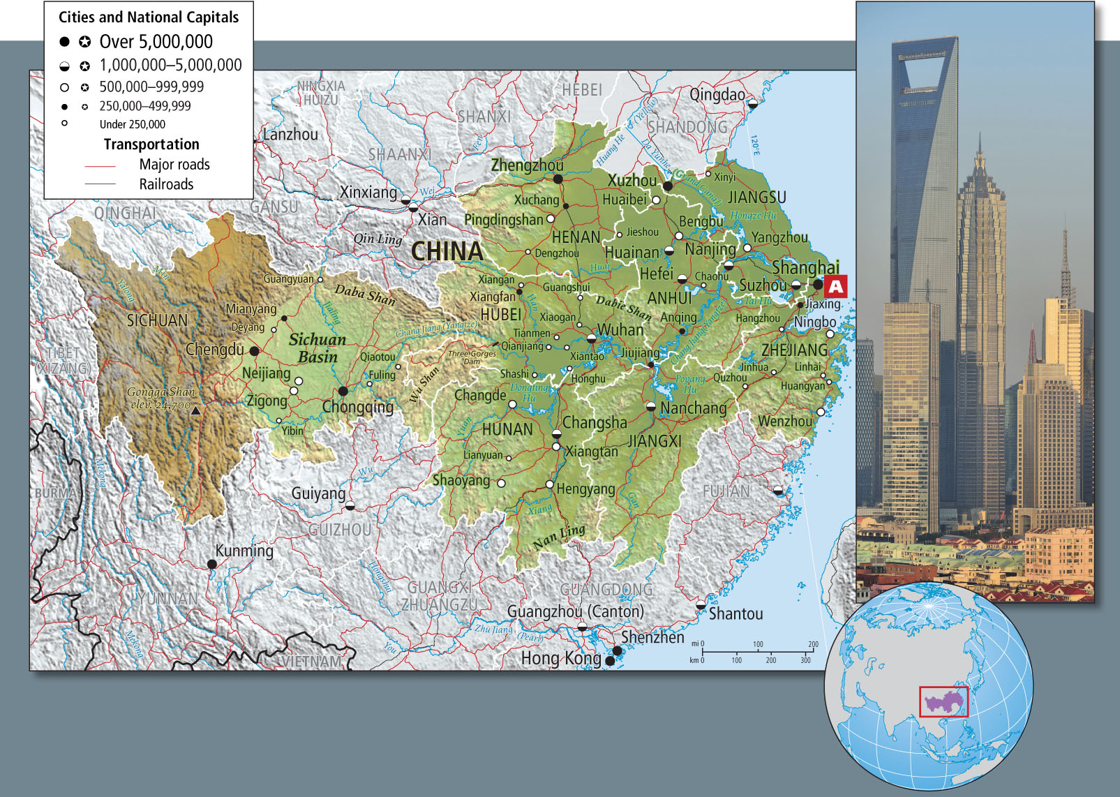
The middle basin and the lower basin have been filled with alluvium (river-borne sediments) carried down from the Plateau of Tibet and the Sichuan Basin. Other rivers entering the middle basin from the north and south also bring in loads of silt, which are added to the main river channel. The Chang Jiang carries a huge amount of sediment—as much as 186 million cubic yards (142 million cubic meters) per year—past the large industrial city of Wuhan. This is particularly pronounced during the rainy season in the summer and early fall (the area is affected by a moderate monsoon). This sediment, which under natural conditions was deposited on the basin floors during annual floods, enriched agricultural production. But because the floods often destroyed people, property, animals, and crops, the Chang Jiang, like the Huang He, now flows between levees. Still, it occasionally breaches the levees and floods both rural and urban areas, as it did most recently in 2010. As the river approaches the East China Sea, it deposits the last of its sediment load in a giant delta, at the outer limits of which lies the trading city of Shanghai.
alluvium river-borne sediment
The climate of the middle and lower basins, though not as pleasant as Sichuan’s, is milder than that of the North China Plain. The Qin Ling range and other, lower hills that extend eastward across the northern limits of the basin block some of the cold northern winter winds. The mountains also trap warm, wet southern breezes, so the basins retain significant moisture during most of the year. The growing season is 9 to 10 months long. The natural forest cover has long since been removed to provide agricultural land for the rural population. Summer crops are rice, cotton, corn, and soybeans; winter crops include barley, wheat, rapeseed (canola), sesame seeds, and broad beans. There are more than 470 million people in the middle and lower basins of the Chang Jiang. In the past, many of them were farmers, but every year more people migrate to the many industrialized cities of the region. Shanghai overshadows all of these cities in importance.
For many centuries, Shanghai’s location facing the East China Sea, with the whole of Central China at its back, positioned the city well to participate in whatever international trade was allowed. When the British forced trade on China in the 1800s, Shanghai became their base of operations. Before the Communist Revolution, Shanghai was among the most cosmopolitan cities on Earth, home to well-educated citizens, wealthy traders, and a goodly number of underworld figures as well. After the revolution, the Communists designated the city as the nexus of capitalist corruption, and it fell into disgrace.
When China began to open up to world trade in the 1980s, Shanghai entrepreneurs were well situated to take advantage of government incentives, such as reduced taxes, assistance in preparing building sites, and permission to take profits out of the country. These incentives helped motivate developers to build factories, workers’ apartment blocks, international banks, luxury apartment houses, shopping malls, and elegant, extraordinarily tall skyscrapers (see Figure 9.35A). Today, some of the Overseas Chinese (see Chapter 10)—particularly those who fled the repression of the Communist Party to places such as Taiwan, Singapore, and Malaysia—have returned to invest in everything from television stations and discotheques to factories, shopping centers, and entertainment parks. Europeans and North and South Americans are attracted to Shanghai, too, hoping to find joint ventures with Chinese partners so that they can tap into the huge pool of consumers emerging in China.
THINGS TO REMEMBER
 Sichuan is among China’s most populous provinces; one of its richest in resources, it is a region of wet rice cultivation, fine fruits and vegetables, and silkworm production.
- The Three Gorges Dam, the world’s largest and perhaps most controversial dam, interrupts the natural flow of the Chang Jiang in the Hubei Province. The river continues across the plain and empties into the ocean at Shanghai, China’s largest city and its economic engine.