1.2 ENVIRONMENT
GEOGRAPHIC INSIGHT 1
Environment: Humans are altering the planet at an unprecedented rate, causing sometimes drastic effects on ecosystems and climate. Multiple environmental factors often interact to influence the vulnerability of a location to the impacts of climate change. These vulnerabilities have a spatial pattern.
1.2.1 HUMAN IMPACT ON THE BIOSPHERE
From the beginning of human life, we have overused resources in seeking to improve our own living conditions, sometimes with disastrous consequences. What is new is the scale of human impacts on the planet, which can now be found virtually everywhere. In fact, geoscientists have recently identified a new geologic epoch, called the Anthropocene, which is defined as the time during which humans have had an overwhelming impact on Earth’s biosphere. Just when the Anthropocene began is under debate.
As people have grown more aware of their environmental impacts, they have put forth numerous proposals to limit damage to the biosphere, defined here as the entirety of the Earth’s integrated physical systems, with humans and their impacts included as part of nature. Societies have become so transformed by the intensive use of Earth’s resources that reversing this level of use is enormously difficult. For example, how possible would it be for you and your entire family to live for even just one day without using any fossil fuels for transportation or home heating or cooling? Would you be able to get to school or work or be comfortable in your home? Intensive per capita resource consumption is now so deeply ingrained, especially in wealthy countries, that with just 20 percent of the world’s population, the rich countries consume more than 80 percent of the available world resources.
biosphere the entirety of the Earth’s integrated physical spheres, with humans and other impacts included as part of nature
Human consumption of natural resources is now being examined through the concept of the ecological footprint. This is a method of estimating the amount of biologically productive land and sea area needed to sustain a human at the average current standard of living for a given population (country). It is particularly useful for drawing comparisons. For example, about 4.5 acres is the worldwide average of the biologically productive area needed to support one person—
ecological footprint the amount of biologically productive land and sea area needed to sustain a person at the current average standard of living for a given population
13
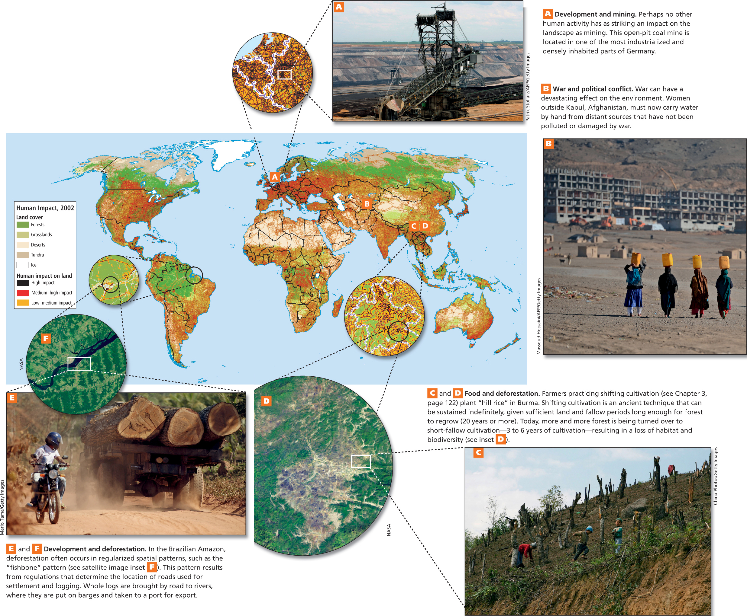
Because the biosphere is a global ecological system that integrates all living things and their relationships, it is important to raise awareness that actions in widely separated parts of Earth have a cumulative effect on the whole. Figure 1.7 shows a global map of the relative intensity of human biosphere impacts. The map includes photo insets that show particular trouble spots in South America (see Figure 1.7E, F), Europe (see Figure 1.7A), South Asia (see Figure 1.7B), and Southeast Asia (see Figure 1.7C, D). However, to fully appreciate human impacts on the biosphere, some understanding of the underlying physical processes that shape the biosphere is needed.
THINKING GEOGRAPHICALLY
Use the Photo Essay above to answer these questions.
Question 1.1
BKQlm2oGyoHAHtVZ2dzoCGCovIF42OrzHwrYamge4TQh5ACXxqS9MTAVPck5r5txtTXawdo21eULJiL4j/36vQ==Question 1.2
3VeHd7ZredaYh2t/X/+JzRu0dcVUMR5dOGCIVGduA+CGWzpYAI1LbSa09NIhdtC7fwrLBUoR+Zi6pObTJdnmkJZKiK2lJexTOXvp7vpqGhkaD8xsQuestion 1.3
R/VFnOrUHMZbyOQ7vhJU5bDRPWkVbGFwAg2AXUQISpI5fC//O9qEuis4EsYR1B832D4yklirJ9pR8o07nuqVOBLoUp/S31A7w6YauLnPuQa4Oxq1eewej+twQSvwbgpkGYMAOyBih6EQbD2tZvjgNmqEkGdLcaenhkyL5ahIJMU3Wotv4lVy78j1omPMXAqGOiL6xM96Y4g=Question 1.4
bZnxRw7nF/5BsOYIA7KNv1AKMp79mJUIWr3u6IsSuCyZEPWD8bca2jD1fKtuTrIgPGL4ni/D+bjziE2lgPQJzHDHZYDNltfPTXOcYFawkZ3ie7W0DNJqhncBKbJ6NgAcuArrMUolMQQFFyDmPmbojuapMospLs7t4qrSImRy9vvck1NKdI4YhC4jk3OiT4GrpmeIfKek40/UkpMIn1iOF7ico895AGTdwlICJA==1.2.2 PHYSICAL GEOGRAPHY
As discussed earlier in this chapter, physical geography is concerned with the processes that shape the Earth’s landforms, climate, and vegetation. In this sense, physical geographers are similar to scientists from other disciplines who focus on these phenomena, though as geographers they often look at problems and depict the results of their analysis spatially. In this book, physical geography provides a backdrop for the many aspects of human geography we discuss. Physical geography is a fascinating, large, and growing field of study worth exploring in greater detail. What follows are just the basics of landforms and climate.
Landforms: The Sculpting of the Earth
The processes that create the world’s varied landforms—mountain ranges, continents, and the deep ocean floor—
landforms physical features of the Earth’s surface, such as mountain ranges, river valleys, basins, and cliffs
Plate Tectonics
Two key ideas related to internal processes in physical geography are the Pangaea hypothesis and plate tectonics. The geophysicist Alfred Wegener first suggested the Pangaea hypothesis in 1912. This hypothesis proposes that all the continents were once joined in a single vast continent called Pangaea (meaning “all lands”), which then fragmented over time into the continents we know today (Figure 1.8). As one piece of evidence for his theory, Wegener pointed to the neat fit between the west coast of Africa and the east coast of South America.
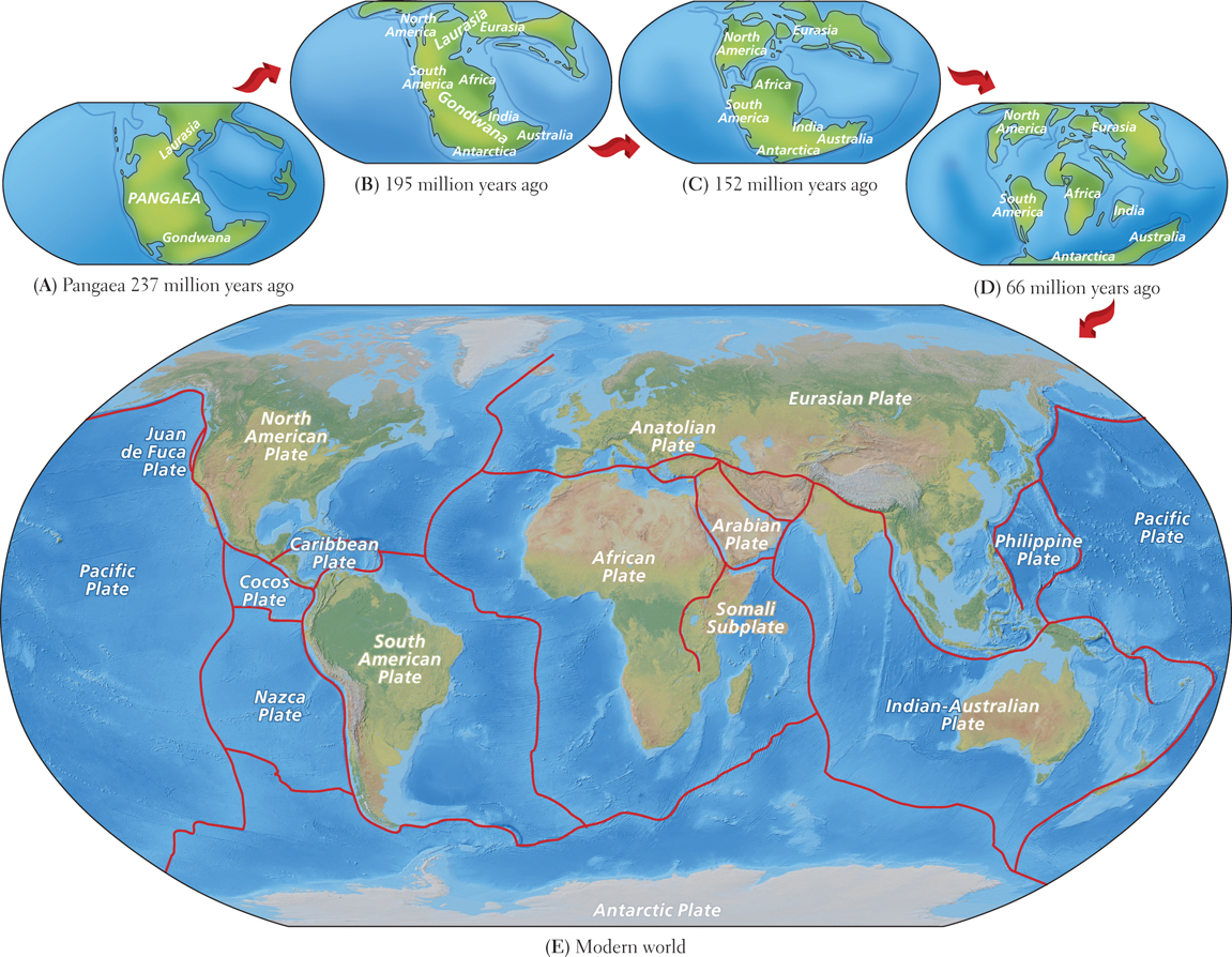
For decades, most scientists rejected Wegener’s hypothesis. We now know, however, that the Earth’s continents have been assembled into supercontinents a number of times, only to break apart again. All of this activity is made possible by plate tectonics, a process of continental motion discovered in the 1960s, long after Wegener’s time.
The study of plate tectonics has shown that the Earth’s surface is composed of large plates that float on top of an underlying layer of molten rock. The plates are of two types. Oceanic plates are dense and relatively thin, and they form the floor beneath the oceans. Continental plates are thicker and less dense. Much of their surface rises above the oceans, forming continents. These massive plates drift slowly, driven by the circulation of the underlying molten rock flowing from hot regions deep inside the Earth to cooler surface regions and back. The creeping movement of tectonic plates fragmented and separated Pangaea into pieces that are the continents we know today (see Figure 1.8E).
plate tectonics the scientific theory that the Earth’s surface is composed of large plates that float on top of an underlying layer of molten rock; the movement and interaction of the plates create many of the large features of the Earth’s surface, particularly mountains
Plate movements influence the shapes of major landforms, such as continental shorelines and mountain ranges. Huge mountains have piled up on the leading edges of the continents as the plates carrying them collide with other plates, folding and warping in the process. Plate tectonics accounts for the long, linear mountain ranges that extend from Alaska to Chile in the Western Hemisphere and from Southeast Asia to the European Alps in the Eastern Hemisphere. The highest mountain range in the world, the Himalayas of South Asia, was created when what is now India, situated at the northern end of the Indian-
Humans encounter tectonic forces most directly as earthquakes and volcanoes. Plates slipping past each other create the catastrophic shaking of the landscape we know as an earthquake. Plates collide and one slips under the other in a process called subduction. Volcanoes arise at zones of subduction or sometimes in the middle of a plate, where gases and molten rock (called magma) can rise to the Earth’s surface through fissures and holes in the plate. Volcanoes and earthquakes are particularly common around the edges of the Pacific Ocean, an area known as the Ring of Fire (Figure 1.9).
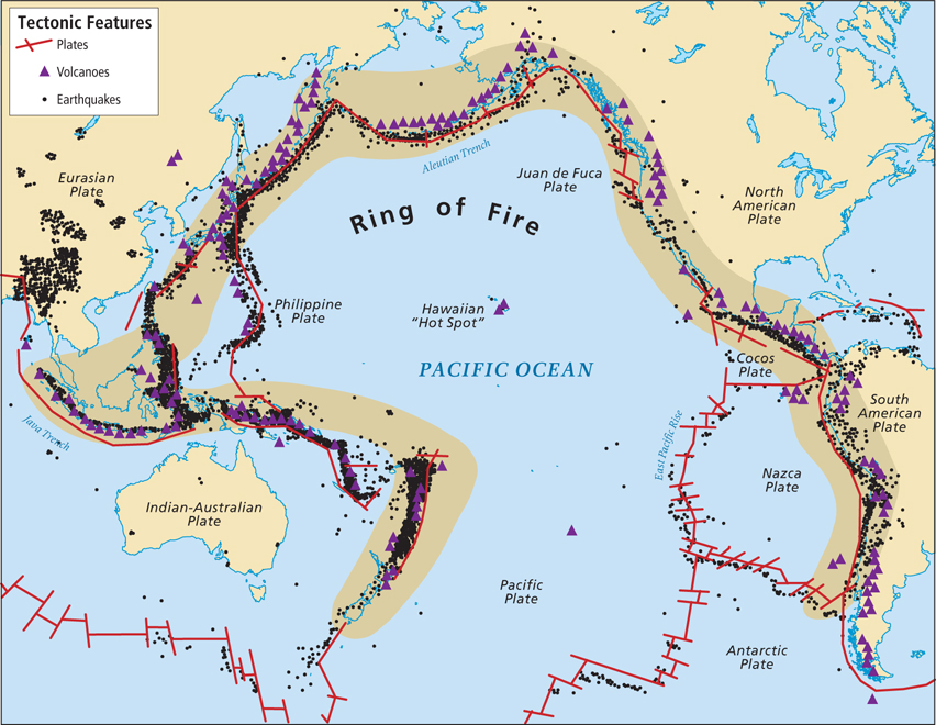
Ring of Fire the tectonic plate junctures around the edges of the Pacific Ocean; characterized by volcanoes and earthquakes
Landscape Processes
The landforms created by plate tectonics have been further shaped by external processes, which are more familiar to us because we can observe them daily. One such process is weathering. Rock, exposed to the onslaught of sun, wind, rain, snow, ice, freezing and thawing, and the effects of life-
weathering the physical or chemical decomposition of rocks by sun, rain, snow, ice, and the effects of life-
floodplain the flat land along a river where sediment is deposited during flooding
delta the triangular-
erosion the process by which fragmented rock and soil are moved over a distance, primarily by wind and water
14
Human activity often contributes to external landscape processes. By altering the vegetative cover, agriculture and forestry expose the Earth’s surface to sunlight, wind, and rain. These agents in turn increase weathering and erosion. Flooding becomes more common because the removal of vegetation limits the ability of the Earth’s surface to absorb rainwater. As erosion increases, rivers may fill with silt, and deltas may extend into the oceans.
Climate
The processes associated with climate are generally more rapid than those that shape landforms. Weather, the short-
weather the short-
climate the long-
Solar energy is the engine of climate. The Earth’s atmosphere, oceans, and land surfaces absorb huge amounts of solar energy, and the differences in the amounts they absorb account for part of the variations in climate we observe. The most intense direct solar energy strikes the Earth more or less head-
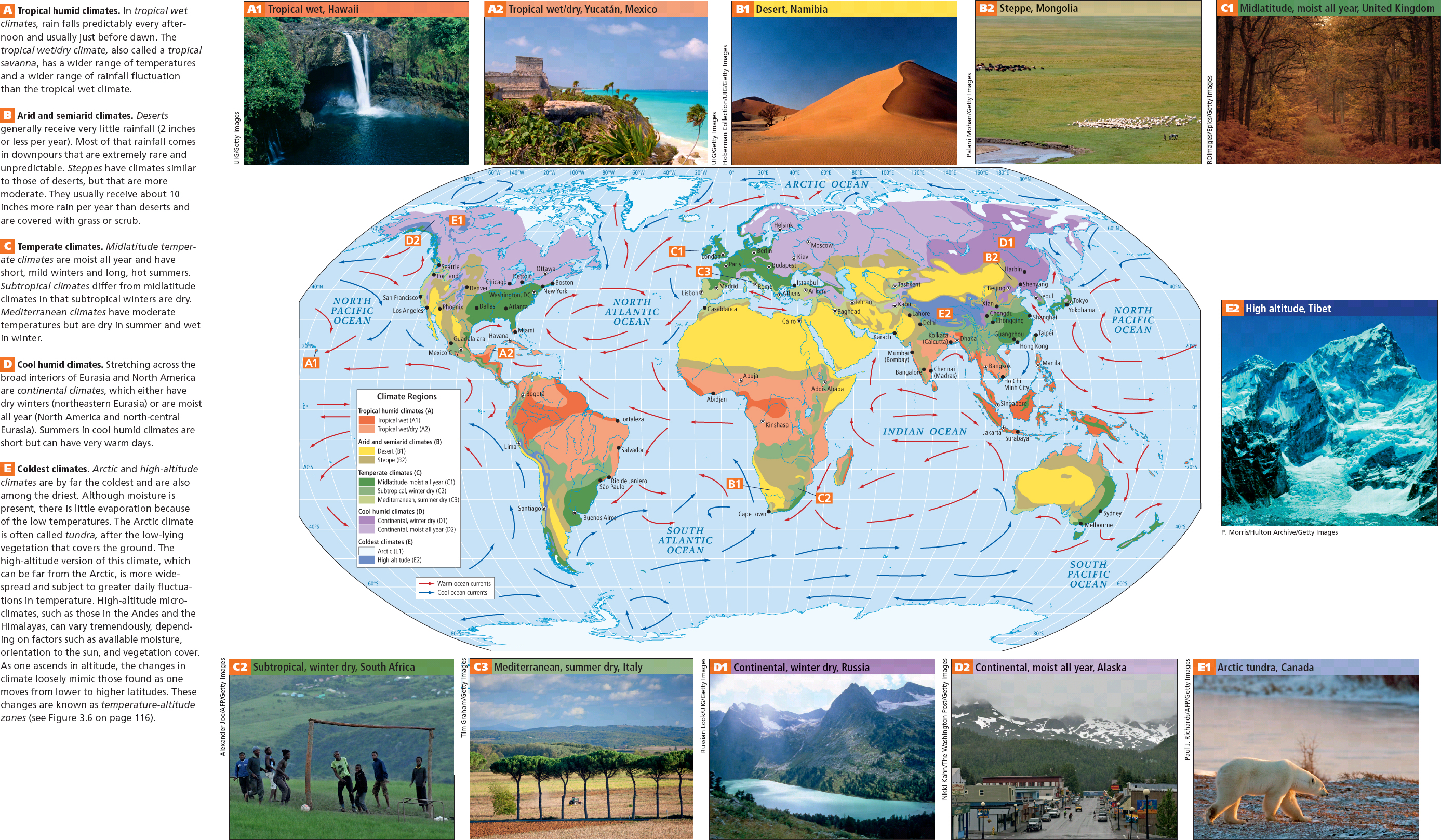
Climate Regions
Geographers have several systems for classifying the world’s climates. The systems are based on the patterns of temperature and precipitation just described. This book uses a modification of the widely known Köppen classification system, which divides the world into several types of climate regions, labeled A through E on the climate map in Figure 1.11. As you look at the regions on this map, examine the photos, and read the accompanying climate descriptions, you will notice the importance of climate to vegetation. Each chapter includes a climate map about the region being discussed; when reading these maps, refer to the written descriptions in Figure 1.11 as necessary. Keep in mind that the sharp boundaries shown on climate maps are in reality much more gradual transitions.
15
16
Temperature and Air Pressure
The daily wind and weather patterns are largely a result of variations in solar energy absorption that create complex patterns of air temperature and air pressure. To understand air pressure, think of air as existing in a particular unit of space—
As the sun warms a unit of cool air, the molecules move farther apart. The air becomes less dense and exerts less pressure. Air tends to move from areas of higher pressure to areas of lower pressure, creating wind. If you have been to the beach on a hot day, you may have noticed a cool breeze blowing in off the water. This happens because land heats up (and cools down) faster than water, so on a hot day, the air over the land warms, rises, and becomes less dense than the air over the water. This causes the cooler, denser air to flow inland. At night the breeze often reverses direction, blowing from the now cooling land onto the now relatively warmer water.
17
These air movements have a continuous and important influence on global weather patterns and are closely associated with land and water masses. Because continents heat up and cool off much more rapidly than the oceans that surround them, the wind tends to blow from the ocean to the land during summer and from the land to the ocean during winter. It is almost as if the continents were breathing once a year, inhaling in summer and exhaling in winter.
Precipitation
Perhaps the most tangible way we experience changes in air temperature and pressure is through rain or snow. Precipitation (dew, rain, sleet, and snow) occurs primarily because warm air holds more moisture than cool air. When this warmer moist air rises to a higher altitude, its temperature drops, reducing its ability to hold moisture. The moisture condenses into drops to form clouds and may eventually fall as rain or snow.
precipitation dew, rain, sleet, and snow
Several conditions that encourage moisture-
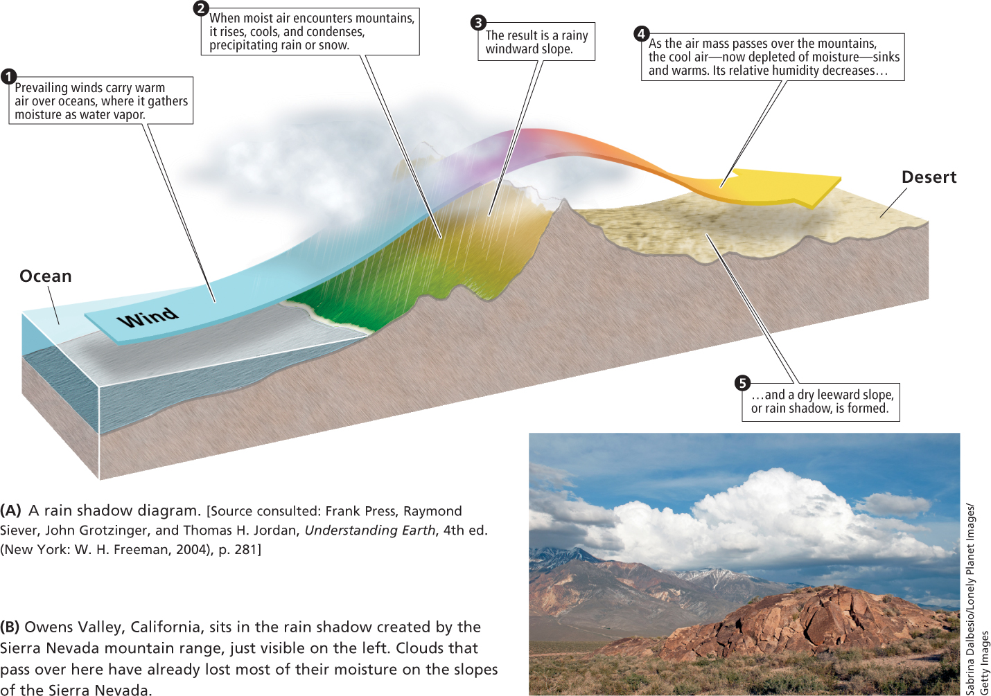
orographic rainfall rainfall produced when a moving moist air mass encounters a mountain range, rises, cools, and releases condensed moisture that falls as rain
A central aspect of Earth’s climate is the rain belt that exists in equatorial areas. Near the equator, moisture-
18
19
20
In the summer monsoon season, the Eurasian continental landmass heats up, causing the overlying air to expand, become less dense, and rise. The somewhat cooler, yet moist, air of the Indian Ocean is drawn inland. The effect is so powerful that the equatorial rain belt is sucked onto the land (see Figure 8.4). This results in tremendous, sometimes catastrophic, summer rains throughout virtually all of South and Southeast Asia and much of coastal and interior East Asia. The reverse happens in the winter as similar forces pull the equatorial rain belt south during the Southern Hemisphere’s summer.
monsoon a wind pattern in which in summer months, warm, wet air coming from the ocean brings copious rainfall, and in winter, cool, dry air moves from the continental interior toward the ocean
Much of the moisture that falls on North America and Eurasia is frontal precipitation caused by the interaction of large air masses of different temperatures and densities. These masses develop when air stays over a particular area long enough to take on the temperature of the land or sea beneath it. Often when we listen to a weather forecast, we hear about warm fronts or cold fronts. A front is the zone where warm and cold air masses come into contact, and it is always named after the air mass whose leading edge is moving into an area. At a front, the warm air tends to rise over the cold air, carrying warm clouds to a higher, cooler altitude. Rain or snow may follow. Much of the rain that falls along the outer edges of a hurricane is the result of frontal precipitation.
THINGS TO REMEMBER
GEOGRAPHIC INSIGHT 1
Environment Humans are altering the planet at an unprecedented rate, causing sometimes drastic effects on ecosystems and climate. Multiple environmental factors often interact to influence the vulnerability of a location to the impacts of climate change. These vulnerabilities have a spatial pattern.
Landforms are shaped by internal processes, such as plate tectonics, and external processes, such as weathering.
Climate is the long-
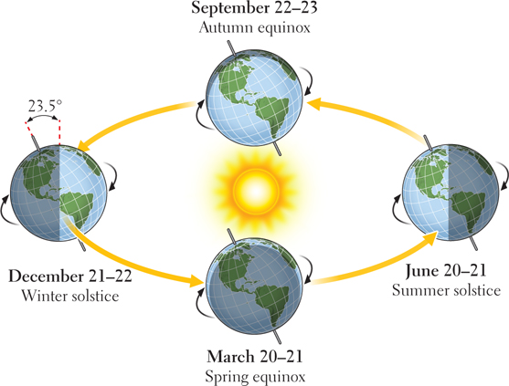
term balance of temperature and precipitation that keeps weather patterns fairly consistent from year to year. Weather is the short- term and spatially limited expression of climate that can change in minutes. Seasons occur because the Earth’s axis is positioned at a consistent angle of 23° as it orbits the sun over the course of a year.
Variations in air pressure are caused by heating and cooling and account for phenomena such as wind and precipitation patterns.
Precipitation occurs primarily because warm air holds more moisture than cool air. When this warmer moist air rises to a higher altitude, its temperature drops, reducing its ability to hold moisture, resulting in rain or snow.
21