6.2 PHYSICAL GEOGRAPHY AND ENVIRONMENTAL ISSUES
PHYSICAL PATTERNS
Landforms and climates are particularly closely related in this region. The climate is dry and hot in the vast stretches of the relatively low, flat land; it is somewhat moister where mountains capture orographic rainfall. The lack of vegetation perpetuates aridity. Without plants to absorb and hold moisture, the rare but occasionally copious rainfall simply runs off, evaporates, or sinks rapidly into underground aquifers, of which there are many across the region.
Climate
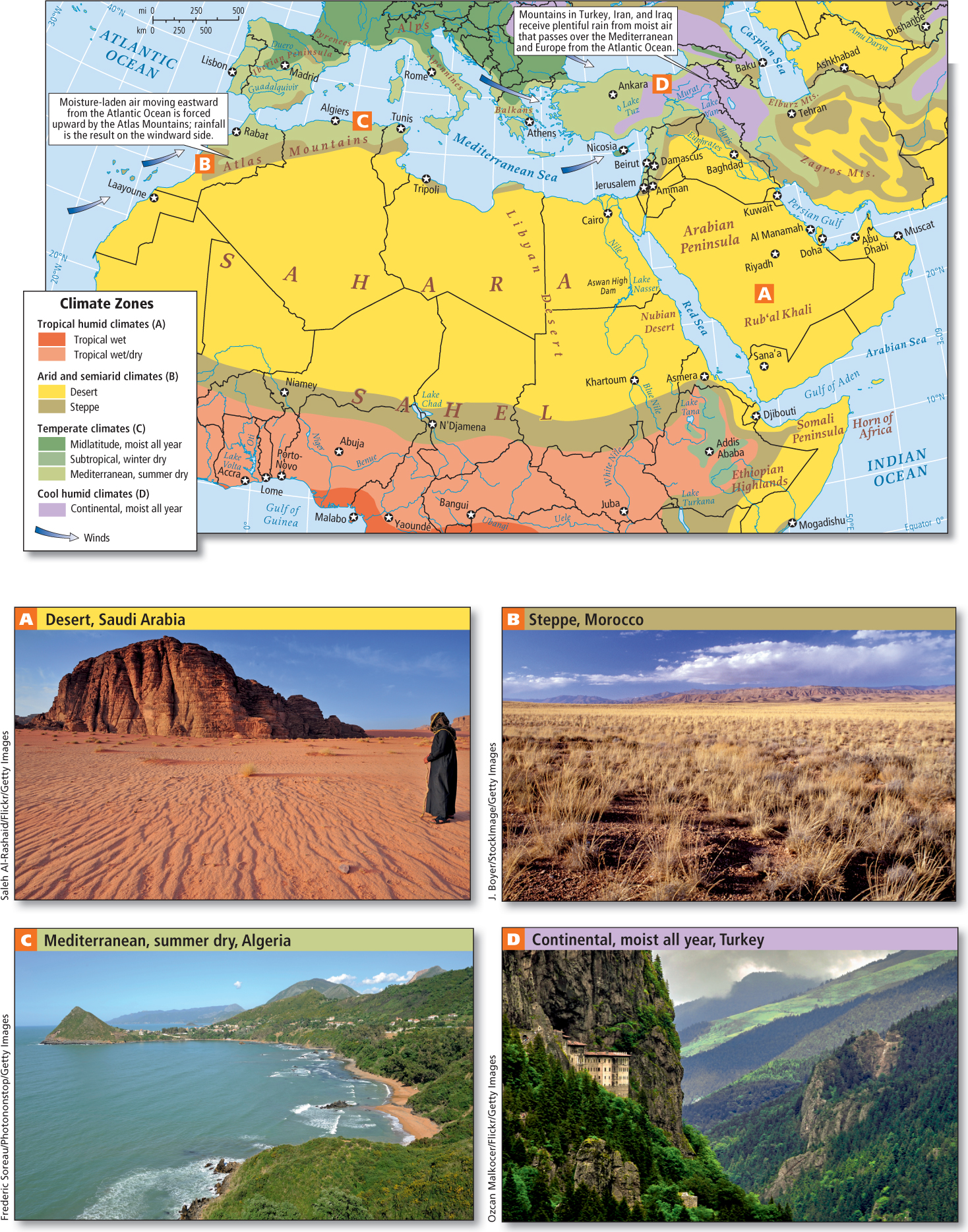
No other region in the world is as dry as North Africa and Southwest Asia (Figure 6.5A). A belt of dry air that circles the planet between roughly 20° N and 30° N creates desert climates in the Sahara of North Africa, the eastern Mediterranean, the Arabian Peninsula, Kuwait, Iraq, and Iran.
The Sahara’s size and location under this high-
In the uplands and at the desert margins, enough rain falls to nurture grass, some trees, and limited agriculture. Such is the case in northwestern Morocco; along the Mediterranean coast in Algeria, Tunisia, and Libya; in the highlands of Sudan, Yemen, and Turkey; and in the northern parts of Iraq and Iran (see Figure 6.5B–D). The rest of the region, generally too dry for cultivation, has for generations been the prime herding lands for nomads, such as the Kurds of Southwest Asia, the Berbers and Tuareg (a branch of Berbers) in North Africa, and the Bedouin of the steppes and deserts on the Arabian Peninsula. Recently, most nomads have been required to settle down; some of their lands are now irrigated for commercial agriculture, but the general aridity of the region means that sources of irrigation water (rivers and aquifers) are scarce.
Landforms and Vegetation
The rolling landscapes of rocky and gravelly deserts and steppes cover most of North Africa and Southwest Asia (see the Figure 6.1 map and Figure 6.5). In a few places, mountains capture sufficient moisture to allow plants, animals, and humans to flourish. In northwestern Africa, the Atlas Mountains, which stretch from Morocco on the Atlantic coast to Tunisia on the Mediterranean coast, lift damp winds from the Atlantic Ocean, creating orographic rainfall of more than 50 inches (127 centimeters) per year on windward slopes (see Figure 6.1B). In some Atlas Mountain locations, there is enough snowfall to support a ski industry.
A rift that formed between two tectonic plates—
Behind these mountains, to the northeast of the Arabian Peninsula, lies the great desert region of the Rub‘al Khali. Like the Sahara, it has virtually no vegetation. The sand dunes of the Rub‘al Khali, which are constantly moved by strong winds, are among the world’s largest, some as high as 2000 feet (610 meters; see Figure 6.1D).
The landforms of Southwest Asia are more complex than those of North Africa. The Arabian Plate is colliding with the Eurasian Plate and pushing up the mountains and plateaus of Turkey and Iran (see Figure 1.8). Turkey’s mountains lift damp air that passes over Europe and the Mediterranean from the Atlantic, resulting in considerable rainfall (see Figure 6.1E). Only a little rain makes it over the mountains to the interior of Iran, which is very dry. The tectonic movements that create mountains also create earthquakes, a common hazard in Southwest Asia.
There are only three major river systems in the entire region, and all have attracted human settlement for thousands of years. The Nile flows north from the moist central East African highlands (see Figure 6.1F). It crosses arid Sudan and desert Egypt and forms a large delta on the Mediterranean. The Euphrates and Tigris rivers both begin with the rain that falls in the mountains of Turkey. The rivers then flow southeast to the Persian Gulf. A much smaller river, the Jordan, starts as snowmelt in the uplands of southern Lebanon and flows through the Sea of Galilee to the Dead Sea. Most other streams are for most of the year dry riverbeds, or wadis, carrying water only after the generally light rains that fall between November and April (Figure 6.1G shows a wadi in Morocco).
North Africa and Southwest Asia were home to some of the very earliest agricultural societies. Today, rain-
236
237
6.2.1 ENVIRONMENTAL ISSUES
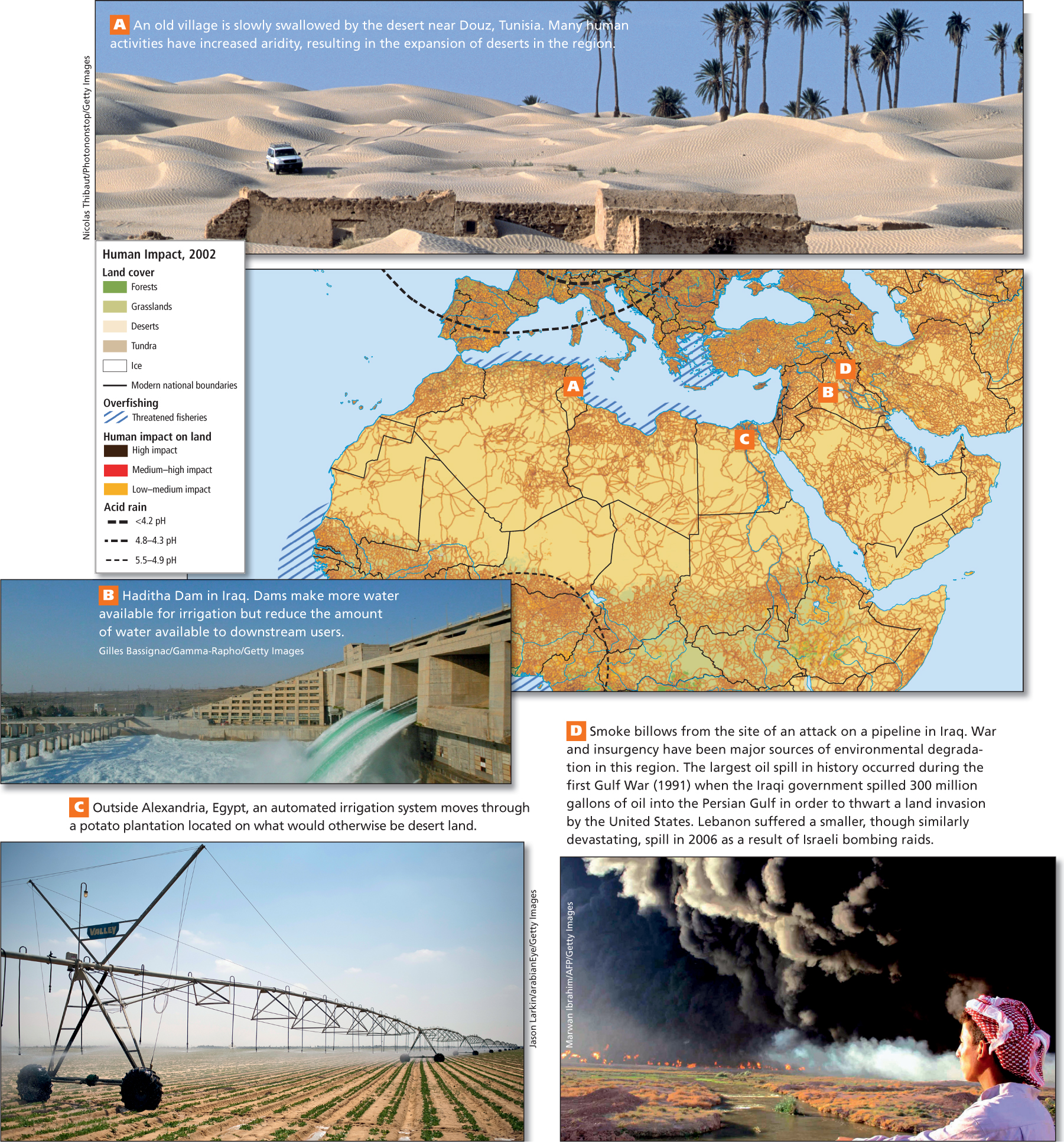
Environmental concerns are only beginning to be an overt focus in this region. This is in part because for thousands of years people here have confronted the challenges of a naturally arid environment and have been quite attuned to its scarcities, which exceed those in most other places on Earth (Figure 6.6).
An Ancient Heritage of Water Conservation
GEOGRAPHIC INSIGHT 1
Environment: The population of this predominantly dry region is growing faster than is access to cultivable land and water for agriculture and other human uses. Many countries here are dependent on imported food, and because global food prices are unstable, the region often has food insecurity. Climate change could reduce food output both locally and globally and make water, already a scarce commodity, a source of conflict. New technologies offer solutions to water scarcity but are expensive and unsustainable.
The Qur’an (or Koran), the holy book of Islam, guides believers to avoid spoiling or degrading human and natural environments and to share resources, especially water, with all forms of life. In actual practice, the residents of this region conserve water better than most people in the world. Daily bathing is a religious requirement and is often done in public baths, where water use is minimized. For millennia, mountain snowmelt has been captured and moved to dry fields and villages via constructed underground water conduits, called qanats, that minimize evaporation. Likewise, traditional architectural designs that maximize shade and airflow are used to create buildings that stay cool.
Qur’an (or Koran) the holy book of Islam, believed by Muslims to contain the words Allah revealed to Muhammad through the archangel Gabriel
Despite their history of water-
THINKING GEOGRAPHICALLY
Use the Photo Essay above to answer these questions.
Question 6.1
mAPqMzLEfCs1KaYH2PHFk2SKHhiO4lVbSK2QO0Q4xFcN8W2MSRqINpfWuuVVdAG4+Dt3vgOtiEYP6BSRPfgOXnhdP2TSrVvRoRg8SYoNPucOvl80NrTU6WquURHVHUyz+PQZJOyM46MCJMkuECsZV1HVH6ZvQsBD3IiLOGYPqt4kvQu3tvuGGQ==Question 6.2
DRUYL0ib1mr3AmhRuY1BQJmBYN2l7lgZ9ktM4yn5a88wBTMwcQwbkOjMyQPWB7k1YpcREK6A7eR8HqM8U+bVmdwZYWBSYNvGX2LV6viB4U4FFfd3fJFw3aRdHHUG+0wFn8tGTiX2KGhLpDSkfLWErSqY2eyksXJCXKHXqlURnyWtFB3eOVo8R6SDj5Z3AzVZfSsAdC7SC0011BfY1BYNyWsJDG1fe7j1mpFzWH7hi0VmOmiJ4146ftcIjTipw6P5paq5kAvvyUYrQl66EOKu0z8czfKnC3ufYsFLtadbtRfFuLUuV2NB2b+HxEol09PA238
239
Could There Be New Sources of Water?
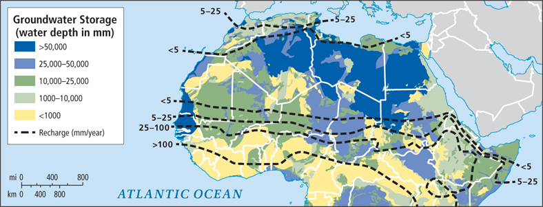
A recent reassessment of groundwater storage in North Africa by a consortium of British scientists revealed that deep aquifers in Algeria, Libya, Egypt, and Sudan may hold up to 100 times the water available through renewable freshwater resources (Figure 6.8). This fossil water, deposited thousands of years ago, is unevenly distributed and so deep that special pumps are required to bring it to the surface. There probably isn’t enough to meet the expected increases in demand for agricultural irrigation and drinking water for rapidly growing urban populations, but this stored groundwater may help alleviate scarcities caused by climate variability.
Water and Food Production
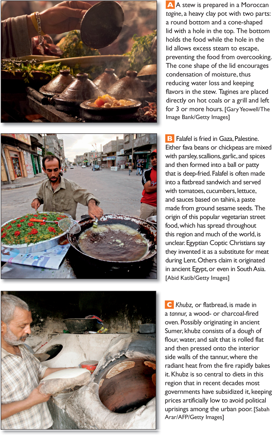
The predominant use of water in North Africa and Southwest Asia is for irrigated agriculture, even though agriculture does not contribute significantly to national economies. In Tunisia, for example, agriculture accounts for just 10 percent of GDP but 86 percent of all the water used. Just 13 percent of water is used in homes, and only 1 percent by industry. Most national governments actually subsidize irrigated agriculture because they are worried about depending completely on imported food. Irrigated agriculture also supports jobs and family economies that are crucial to rural communities. Some of this region’s food specialties appear in Figure 6.9.
Until the twentieth century, agriculture was confined to a few coastal and upland zones where rain could support cultivation, and to river valleys (such as the Nile, Tigris, and Euphrates valleys) where farms could be irrigated with simple gravity-
Over time, irrigation projects damage soil fertility through salinization. When irrigation is used in hot, dry environments, the water evaporates, leaving behind a salty residue of minerals. When too much residue accumulates, the plants are unable to grow or even survive. This human-
salinization a process that occurs when large quantities of water are used to irrigate areas where evaporation rates are high, leaving behind dissolved salts and other minerals
Israel has developed relatively efficient techniques of drip irrigation that dramatically reduce the amount of water used, thereby limiting salinization and freeing up water for other uses. Until very recently, however, poorer states have been unable to afford this somewhat complex technology, which requires an extensive network of hoses and pipes to deliver water to each plant.
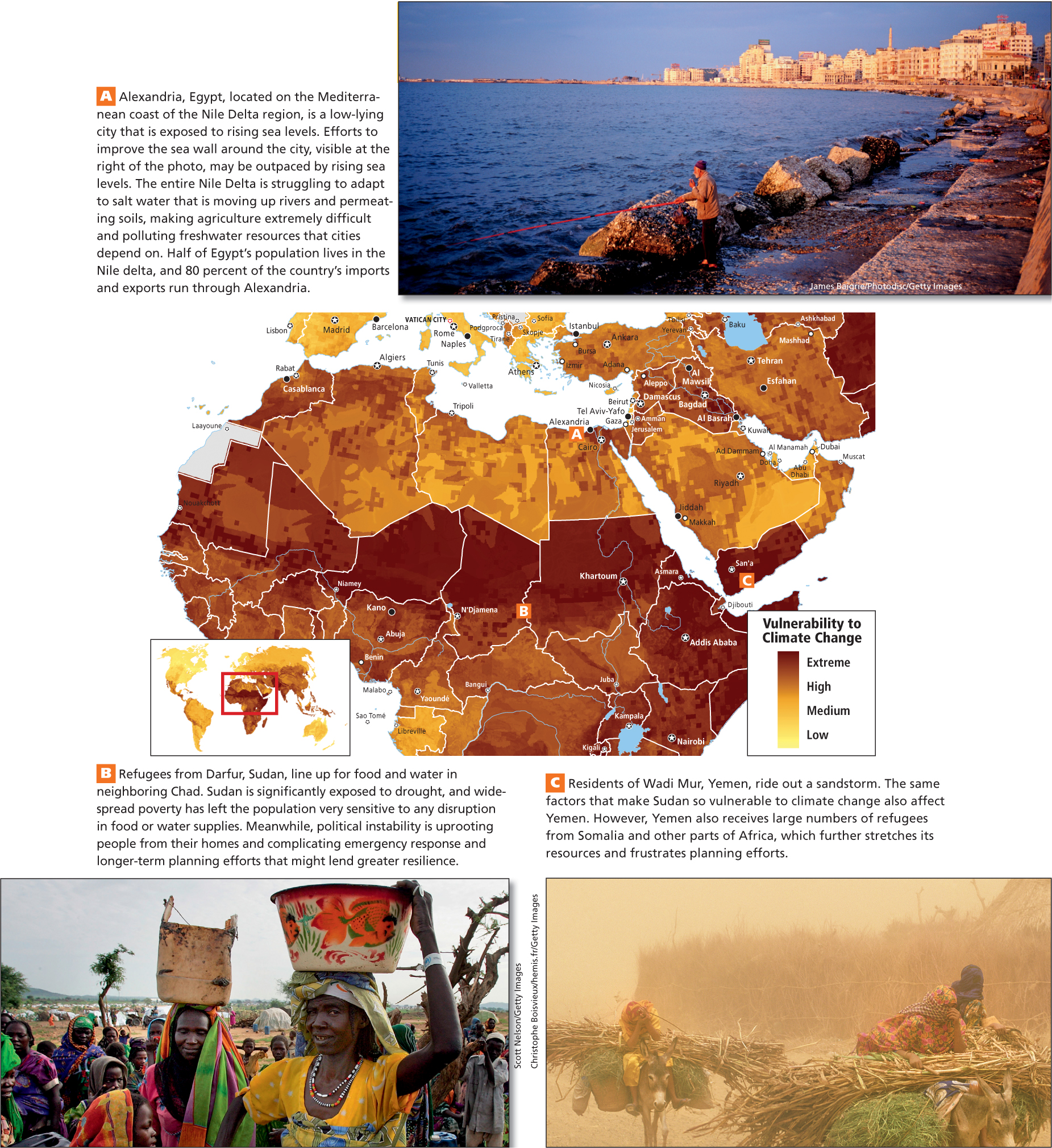
Vulnerability to Climate Change
North Africa and Southwest Asia are especially vulnerable to the multiple effects of climate change. Higher temperatures are already increasing evaporation rates where water scarcity has been a problem for many years (Figure 6.10B, C). These climatic changes, along with people’s intensified use of water, are transforming more nondesert lands into deserts. Also, as the climate warms, a sea level rise of a few feet could severely impact the Mediterranean coast, especially the Nile Delta, one of the poorest and most densely populated lowland areas in the world (see Figure 6.10A), and the Persian Gulf coasts, where vast new high-
THINKING GEOGRAPHICALLY
Use the Photo Essay above to answer these questions.
Question 6.3
KCIow7aKdIS0xw7bv/1YJxbahugrKcps1eh1jFPChLNyw8ahy2E7ZhxJdrtQfp8zuvTPDq+Du+Tu8HaEn74GOfxO+7IQ4dhf81QV6emclJCcyUyU7WCKwjPVs1aBsCDotN1vGKz760gnuzD+y3C31Q==Question 6.4
yT25DwJV6NtkRMiYFrEjSio+zir2WP0DtAq0pZ9vtfhGpbk1lZwyvYX6dk+VcTMqedRpEydr6fULBFisqqx7h2sOa5Flp6mlP0NkpQmgbLxN0he9bXcH78IwUJ4yre22//GRu2MOFKKMXLVyVYwHxpHQj6ZEz69lEGmvV3l1U/9pjQfOfZctEliil+1mVwfV2X1Aew==Question 6.5
Amqnc47iuUEuXUqvLXDzON5cOJQTJTmbvgxuK7BxA4wS8P4Kzi2WU2/zoa4j4477I33jA0EQ5Z3CfOZAAOTy677/GxCR2yIZY6ph2VIqvpSxNKe9/80k7diI527TTf1Mn/CzqPJuW6RfZ37HcvQ0coTWA+RzmpnT3mbP+yRw8bkqEPM9c3BDeqOq6rk=Independent of any environmental effects of climate change, global efforts to reduce dependencies on fossil fuel consumption could devastate oil-
Climate Change and Desertification Climate change could accelerate desertification, the conversion of nondesert lands into deserts (see Figure 6.7A). As temperatures increase, soil moisture decreases because of evaporation. As a result, plant cover is reduced, which causes less protection for arid soil. Bare patches of soil can become badly eroded by wind, and eventually sand dunes can blow onto formerly vegetated land.
desertification a set of ecological changes that converts arid lands into deserts
In the grasslands (steppes) that often border deserts, a wide array of land use changes contribute to the general drying. For example, as groundwater levels fall because water is being pumped out for cities and irrigated agriculture, some plant roots no longer reach sources of moisture, causing the plants to die. In other cases, international development agencies have inadvertently contributed to desertification by encouraging nomadic herders to take up settled cattle ranching of the type practiced in western North America. Agencies encourage settlement because the mobility of nomads is viewed as complicating management for modern state bureaucracies where records must be kept, taxes collected, and children sent to school with regularity. However, ranching on fragile grasslands can lead to overgrazing, which can kill the grasses and increase evaporation. If irrigation is used to support ranching, such projects can also deplete groundwater resources, resulting in long-
Imported Food and Virtual Water Because agriculture is so difficult due to the aridity of this region, the diets of nearly all people here include imported food. The total per capita water use of this region must thus include the water used to produce this imported food. Virtual water is the volume of water used to produce all that a person consumes in a year (see Chapter 1). For example, 1 kilogram (2.2 pounds) of beef requires 15,500 liters (4094 gallons) of water to produce, while 13 kilogram of goat meat requires just 4000 liters (1056 gallons). Goat meat, which is popular in this region and produced locally, has a much less significant water component than beef, but beef consumption is on the rise. One kilogram of corn requires 900 liters (238 gallons) of water, and 1 kilogram of wheat, 1350 liters (357 gallons). Beef, corn, and wheat are common imports; in fact, North Africa and Southwest Asia import more wheat than any other world region.
Strategies for Increasing Access to Water Some strategies have been developed for increasing supplies of fresh water, but each presents a set of difficulties. All of them are expensive and some have enormous potential to cause more wasting of water.
Seawater desalination The fossil fuel–
seawater desalination the removal of salt from seawater—
Groundwater pumping Many countries pump groundwater from underground aquifers to the surface for irrigation or drinking water. Under Muammar el-
240
241
242
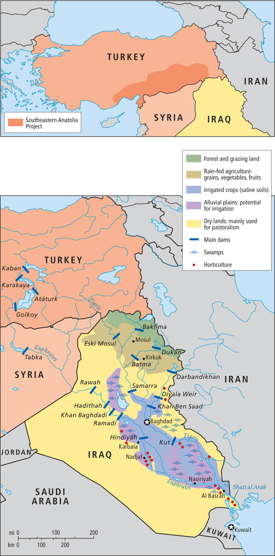
Dams and reservoirs Dams and reservoirs built on the regions’ major river systems to increase water supplies have created new problems. In Egypt, for example, the natural cycles of the Nile River have been altered by the construction of the Aswan dams. Downstream of these two dams, water flows have been radically reduced, making it necessary to use supplemental irrigation, which leads to soil salinization (see Figure 6.7C), and the lack of flooding means that fertility-
Dams as water- 285. THE JORDAN RIVER IS DYING
THINGS TO REMEMBER
Landforms and climates are particularly closely related in this driest region in the world. Rolling deserts and steppes cover most of the land. In a few places, mountains capture moisture, allowing plants, animals, and humans to flourish.
GEOGRAPHIC INSIGHT 1
Environment The population of this predominantly dry region is growing faster than is access to cultivable land and water for agriculture and other human uses. Many countries here are dependent on imported food, and because global food prices are unstable, the region often has food insecurity. Climate change could reduce food output both locally and globally and make water, already a scarce commodity, a source of conflict. New technologies offer solutions to water scarcity but are expensive and unsustainable.
243