The distribution of species around the world is affected by Earth’s history
When we consider the patterns of species diversity on Earth, we need to remember that Earth was formed 4.5 billion years ago and life arose during the first billion years. This means that the species on Earth today are the result of billions of years of evolution and that current diversity arose in response to past environmental conditions. In this section, we will examine how the movement of continents and historic changes in climate affected the distribution of species.
Continental Drift
During Earth’s history, the continents have repeatedly come together and drifted apart. The movement of landmasses across the surface of Earth is called continental drift. Continental drift occurs because the continents are essentially giant islands of low-density rock that are moved by convection currents of semi-molten material. About 250 Mya, all of Earth’s landmasses were joined together as a single landmass, which scientists have named Pangaea, illustrated in Figure 22.25. By 150 Mya, Pangaea had separated into a northern landmass, known as Laurasia, and a southern landmass, known as Gondwana. Laurasia subsequently split into North America, Europe, and Asia while Gondwana split into South America, Africa, Antarctica, Australia, and India. Ultimately, India collided into Asia, which caused the land to rise and created the Himalayas. In the Northern Hemisphere, a widening Atlantic Ocean separated Europe from North America, but a land bridge had already formed on the other side of the world between North America and Asia. More recently, Europe and Africa joined about 17 Mya and a land bridge formed between North and South America at the Isthmus of Panama 3 to 6 Mya.
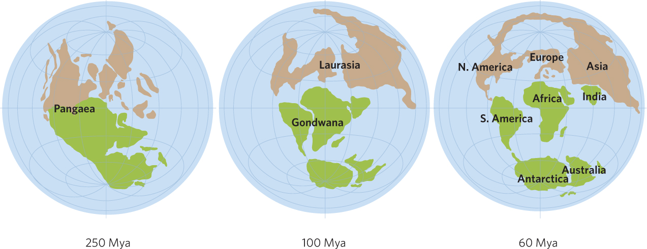
Continental drift The movement of landmasses across the surface of Earth.
Pangaea The single landmass that existed on Earth about 250 Mya and subsequently split into Laurasia and Gondwana.
Laurasia The northern landmass that separated from Pangaea about 150 Mya and subsequently split into North America, Europe, and Asia.
Gondwana The southern landmass that separated from Pangaea about 150 Mya and subsequently split into South America, Africa, Antarctica, Australia, and India.
An important consequence of continental drift was the changing opportunities for dispersal among continents. Once separated, continents could independently evolve species in different regions of Earth. For instance, because Australia has experienced a long period of isolation from other continents, it has evolved many unique groups of species that include a wide variety of marsupial animals, such as koalas and kangaroos, and plants, such as eucalyptus trees. When continents later joined together, groups of organisms that were unique to one landmass were able to move into new areas. You may recall from Chapter 3 that camels originated in North America about 30 Mya. When North America became connected to Asia at the Bering Land Bridge in Alaska, camels dispersed into Asia and then moved into Africa where they diversified into the modern-day Bactrian camels and dromedary camels. At about the same time, other camels dispersed into South America where they further diversified into llamas, guanacos, vicuñas, and alpacas. In short, the history of connections between the continents endures in the distributions of present-day animals and plants.
535
Biogeographic Regions
Because continental drift has allowed individual continents independently to evolve groups of organisms for long periods, we can see patterns of species distributions on each continent. Alfred Wallace, a contemporary of Charles Darwin and codiscoverer of evolution by natural selection, first described these patterns and delineated six major zoogeographic regions that are based on the distributions of animals. These regions, illustrated in Figure 22.26, are still recognized today. Botanists also recognize six major biogeographic regions, based on the distributions of plants, with boundaries that closely coincide with those of the zoogeographic regions.
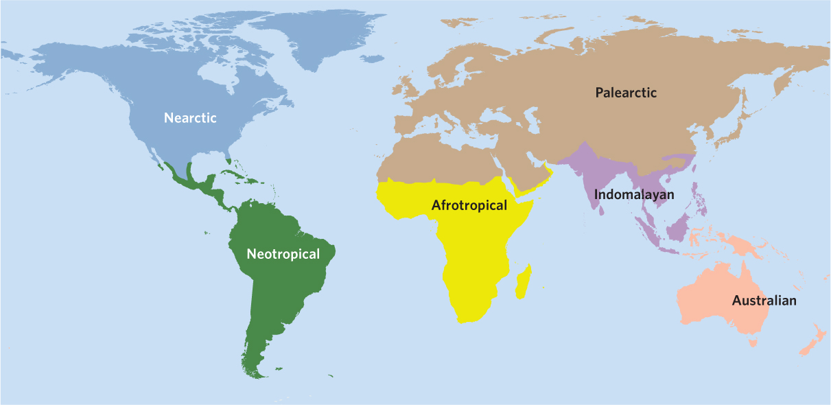
Nearctic region The biogeographic region of the Northern Hemisphere that roughly corresponds to North America.
The Northern Hemisphere is divided into the Nearctic region, which roughly corresponds to North America, and the Palearctic region, which corresponds to Eurasia. Through most of the past 100 million years the continents of these regions maintained connections across what is now Greenland between North America and Eurasia and across the Bering Strait between Alaska and Russia. Consequently, these two regions share many groups of animals and plants. European forests seem familiar to tourists from North America, and vice versa; although few species are the same, both regions have representatives of many of the same genera and families.
Palearctic region The biogeographic region of the Northern Hemisphere that corresponds to Eurasia.
Neotropical region The biogeographic region of the Southern Hemisphere that corresponds to South America.
The Southern Hemisphere is divided into four biogeographic regions. The Neotropical region corresponds to South America and the Afrotropical region, also known as the Ethiopian region, corresponds to most of Africa. Farther to the east is the Indomalayan region, also known as the Oriental region, which includes India and Southeast Asia. The final biogeographic region is the Australasian region, which includes Australia, New Zealand, and New Guinea. In Wallace’s delineation, the continent of Antarctica was not included.
Afrotropical region The biogeographic region of the Southern Hemisphere that corresponds to most of Africa. Also known as Ethiopian region.
Indomalayan region The biogeographic region of the Southern Hemisphere that corresponds to India and Southeast Asia. Also known as Oriental region.
Australasian region The biogeographic region of the Southern Hemisphere that corresponds to Australia, New Zealand, and New Guinea.
Each of these regions contains unique groups of species that reflect their long histories of isolation from the rest of the terrestrial world and the subsequent exchange of species after they were joined together. For example, when the Isthmus of Panama joined the Nearctic and Neotropical regions, there was a large, though uneven, exchange of mammals. Many North American lineages moved into South America and caused the extinction of most of the marsupial animals that had come to South America during an earlier connection with Australia. In contrast, only a few mammals moved into North America from South America; the most prominent are the opossums, a group of marsupial mammals.
536
Historic Climate Change
As we saw in Chapter 5, the position of the continents and the circulation of water around the continents influence the variation in climates around the world. Because the continents were drifting over the past 250 million years, it is not surprising that the climates of the world experienced dramatic changes. For example, the polar regions have not always been as cold as they are today. Polar regions have always received relatively little solar energy due to the angle of the sun. However, when oceans extended from the tropics to polar areas, the ocean currents distributed heat more evenly and temperate climates could be found closer to the poles.
We also know from fossil evidence that large portions of North America and Europe once had tropical climates. Tropical forests reached into Russia and Canada and warm temperate forests covered the Bering Land Bridge from Alaska to Asia. Moreover, the Antarctic land connection between South America and Australia supported temperate vegetation and abundant animal life. However, as Antarctica drifted over the South Pole and as North America and Eurasia gradually encircled the northern polar ocean, the Arctic Ocean became largely enclosed between North America and Eurasia. This created a circumpolar ocean current around Antarctica, which caused cooler temperatures at high latitudes. As a result, Earth’s climates became more strongly differentiated from the equator to the poles. Tropical environments contracted into a narrow zone near the equator, and temperate and boreal climate zones expanded. These climate changes had profound effects on the geographic distributions of plants and animals.
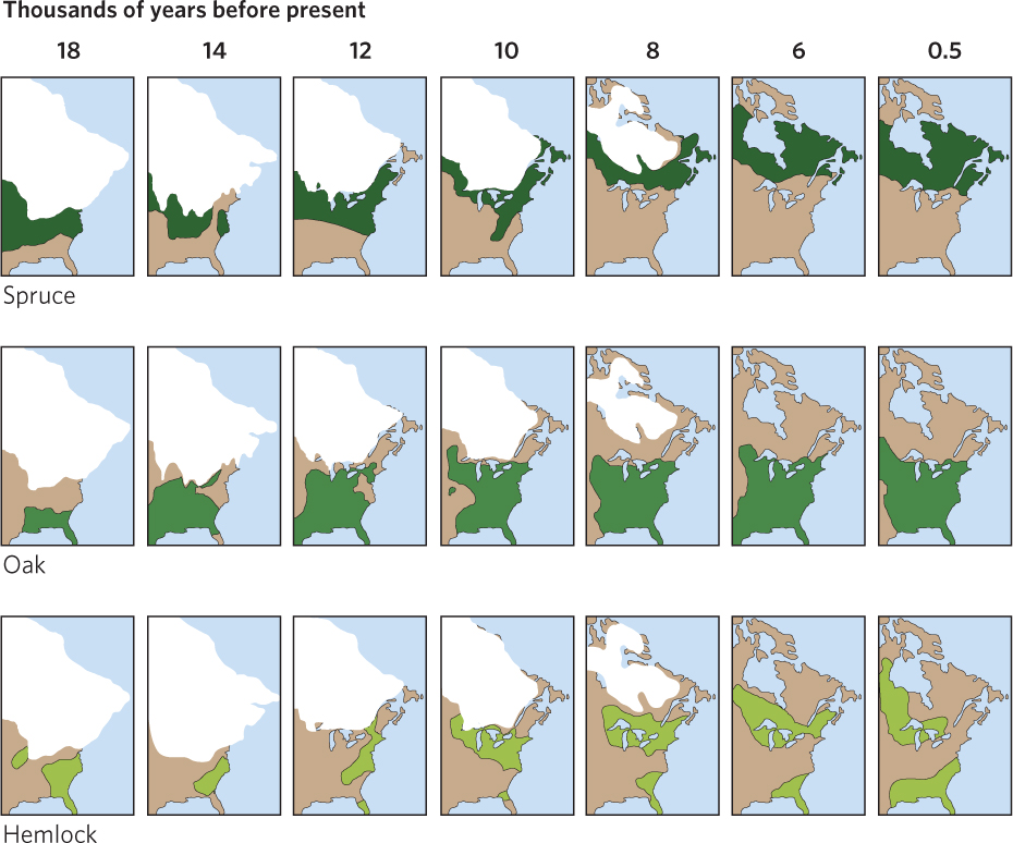
About 2 Mya, the gradual cooling of the planet gave way to a series of dramatic oscillations in climate known as the Ice Age. Climate changes during this time had dramatic effects on habitats and organisms in most parts of the world. Alternating periods of cooling and warming caused the advance and retreat of ice sheets at high latitudes over much of the Northern Hemisphere and cycles of cool, dry climates and warm, wet climates in the tropics. Ice sheets came as far south as Ohio and Pennsylvania in North America and covered much of northern Europe, driving vegetation zones southward, possibly restricting tropical forests to isolated refuges where conditions remained moist.
A striking example of this disruption is the migration of forest trees in eastern North America and Europe. At the peak of the most recent glacial period, many tree species were restricted to southern refuges, but about 18,000 years ago after the ice began to retreat and the forests started to spread north again. Pollen grains deposited in the lakes and bogs left by retreating glaciers record the coming and going of plant species. These records show that the composition of plant associations changed as species migrated back north over different routes across the landscape. The migrations of some representative tree species from their southern refuges are mapped in Figure 22.27. As you can see in this figure, spruce trees shifted northward just behind the retreating glaciers. Oaks expanded out of their southern refuges to cover most of the eastern part of temperate North America, from southern Canada to the Gulf Coast. Hemlocks expanded into the Great Lakes Region and into central Canada.
537
The forests of Europe suffered even more extinctions from the spread of glaciers than those in North America because populations were blocked from shifting southward by the Alps and the Mediterranean Sea. Several northern European tree species went extinct. Many species that survived were restricted to refuges in southern Europe, from which they expanded after the glaciers receded beginning about 18,000 years ago. Recent research suggests that many tree species in Europe have not yet expanded fully into their potential ranges, which suggests that the European flora has not returned to an equilibrium state.
Throughout this chapter, we have seen that to understand the distribution of species, we need to consider ecology at both the landscape scale and the global scale. In doing so, we see that biodiversity is maintained by large-scale factors including area, isolation, and historical events that continue to show their effects today. In “Ecology Today” we will see that this knowledge has helped scientists design a massive nature reserve to help protect the biodiversity of Florida.
ECOLOGY TODAY CONNECTING THE CONCEPTS
TAKING A LONG WALK FOR CONSERVATION
As we have seen throughout this chapter, the distribution and persistence of biodiversity depends on a variety of factors. Knowing the factors responsible for maintaining diversity helps ecologists design nature reserves to protect biodiversity. For example, we know that large habitats typically contain more species than small habitats, so setting aside large nature reserves will better protect biodiversity than setting aside small ones. Similarly, when faced with the option of setting up a single large reserve or several small reserves even of the same total area, the single large reserve is often the better option to preserve biodiversity. However, a single habitat poses more risk from a disease or natural disaster that could destroy the species we are trying to conserve. If we have the opportunity to create multiple reserves, we need to position reserves close enough for organisms to disperse between habitats but far enough away to reduce the ability of predators and diseases to move easily between them. Because increased edge habitat can have detrimental effects on species that prefer to live in the interior of habitats, we also need to consider reserve shape.
538
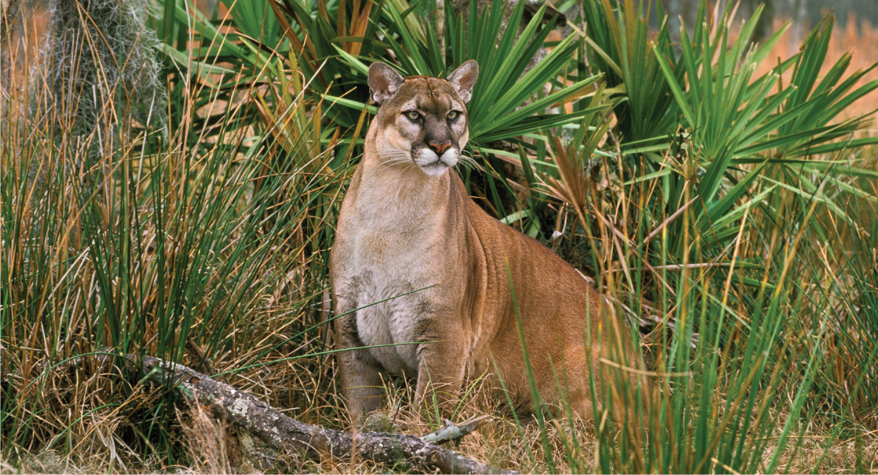
Although we have a good idea about the features of an ideal nature reserve, in reality the design of nature reserves and the corridors that connect them is largely determined by existing habitats, their configurations, and land ownership. An excellent example of this can be found in a conservation effort known as the Florida Wildlife Corridor, a visionary plan to create a continuous connection of protected habitat from the southern tip of Florida all the way up to Georgia. This would provide a large number of species, including endangered species such as the Florida panther, with a tremendous amount of land to inhabit for a long time to come. The ultimate goal is to connect a number of current federal nature reserves, including the Everglades National Park, the Big Cypress National Preserve, the Ocala National Forest, and the Okefenoke National Wildlife Refuge, with a variety of properties owned by the state of Florida, conservation organizations such as The Nature Conservancy, and private landowners including large cattle ranches.
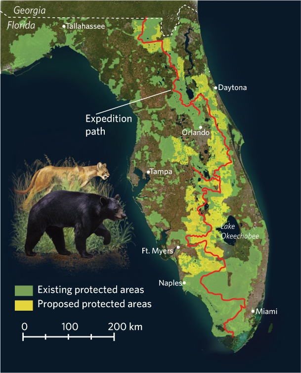
With such a multitude of landowners, the Florida Wildlife Corridor is an excellent case study of the challenges presented by the design of nature reserves. It is as much a sociological problem as an ecological problem, so the promoters of the corridor had to think about a public relations campaign that was as big as the 1,600-km swath of land down the middle of the state. In 2012, four leaders of the project decided to travel the entire length of the proposed corridor in what they referred to as “1,000 miles in 100 days.” Moving on foot and in kayaks, the conservationists traversed swamps, grasslands, and forests. They called attention to their effort by using daily photo and video updates on their websites. Along the way, they were joined by state and federal biologists, conservationists, politicians, and private ranch owners. At every stop, they emphasized that preserving this swath of land through the middle of Florida provided benefits not only to the organisms that lived in undeveloped lands but also to the residents of Florida who rely on tourism as well as on the water and agriculture that comes out of this region. On Earth day 2012, the 100-day expedition was completed at the Stephen C. Foster State Park in southern Georgia.
The effort to protect the land in a north-south corridor through Florida is far from complete, but there is a growing momentum by many people to find a way to protect the lands that lie between the state and federal reserves while at the same time retaining the long-held traditions of agriculture and ranching on the private lands. If such protection can be achieved, then the state will have a total reserve that is both large and interconnected and this should result in the long-term persistence of species in the region.
SOURCES: Lindenmayer, d., et al. 2008. A checklist for ecological management of landscapes for conservation. Ecology Letters 11: 78–91.
The Florida Wildlife Corridor (http://www.floridawildlifecorridor.org/about)