Smaller-scale geographic features can affect regional and local climates
As we have seen, the primary global patterns in Earth’s climate are the result of the unequal solar heating of Earth’s surface. However, a number of other factors have secondary effects on local temperature and precipitation. These include continental land area, proximity to coasts, and rain shadows.
Continental Land Area
The positions of continents exert important secondary effects on temperature and precipitation. For example, oceans and lakes, the sources of most atmospheric water vapor, cover 81 percent of the Southern Hemisphere but only 61 percent of the Northern Hemisphere. Because of this difference, more rain falls at any given latitude in the Southern Hemisphere than in the Northern Hemisphere. The presence of water has a moderating influence on land temperatures, so temperatures in the Northern Hemisphere vary more than they do in the Southern Hemisphere.
Proximity to Coasts
The interior of a continent usually experiences less precipitation than its coasts, simply because the interior lies farther from the oceans, which are the major sources of atmospheric water. Furthermore, as we saw in our discussion of plant hardiness zones, coastal climates vary less than interior climates because the heat storage capacity of ocean water reduces temperature fluctuations near the coast. The ocean warms the air near the coasts during the winter and cools the air near the coasts during the summer. For example, the hottest and coldest average monthly temperatures near the Pacific coast of North America at Portland, Oregon, differ by only 16°C. Farther inland, this range increases to 23°C at Spokane, Washington; 26°C at Helena, Montana; and 33°C at Bismarck, North Dakota.
128
Rain Shadows
Mountains also play a secondary role in determining climates, as we can see in Figure 5.14. When winds blowing inland from the ocean encounter coastal mountains, the mountains force the air upward, which causes adiabatic cooling, condensation, and precipitation. The air, which is now dry and warmed by latent heat release, descends the other side of the mountain, warms adiabatically, and travels across the lowlands beyond, where it creates relatively warm, arid environments called rain shadows. The Great Basin Desert of the western United States, for example, lies in the rain shadow of the Sierra Nevadas and the Cascade Mountains, and covers a large area that includes nearly all of Nevada and much of western Utah. The processes involved in creating rain shadows have much in common with the processes we saw occurring in Hadley cells including adiabatic cooling, adiabatic heating, and release of latent heat.
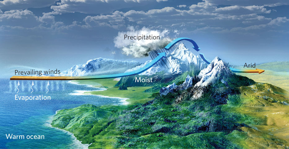
Rain shadow A region with dry conditions found on the leeward side of a mountain range as a result of humid winds from the ocean causing precipitation on the windward side.
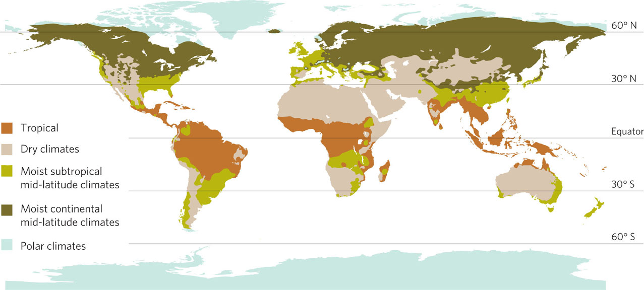
Tropical climate A climate characterized by warm temperatures and high precipitation, occurring in regions near the equator.
We can now use what we have learned to draw a complete picture of worldwide climate distribution. Looking at Figure 5.15, we see repeated patterns that show where different climates exist. Tropical climates, characterized by warm temperatures and high precipitation, occur in regions near the equator. At approximately 30° N and 30° S latitudes, we commonly find the dry climates that experience a wide range of temperatures. Dry climates are not only affected by latitude, however. Many dry climates are caused by rain shadows, for example the extensive regions that lie just east of the Andes Mountains in western South America. Moist subtropical mid-latitude climates are characterized by warm, dry summers and cold, wet winters. Moist continental mid-latitude climates exist at the interior of continents and typically have warm summers, cold winters, and moderate amounts of precipitation. Finally, closest to the poles we find polar climates that experience very cold temperatures and relatively little precipitation.
Dry climate A climate characterized by low precipitation and a wide range of temperatures, commonly found at approximately 30° N and 30° S latitudes.
Moist subtropical mid-latitude climate A climate characterized by warm, dry summers and cold, wet winters.
Moist continental mid-latitude climate A climate that exists at the interior of continents and is typically characterized by warm summers, cold winters, and moderate amounts of precipitation.
Polar climate A climate that experiences very cold temperatures and relatively little precipitation.
129
We have seen the processes that account for different climates around the world. Before we look more closely at the individual climate types and the plants that they support, we need to know something about the formation of soil, which supports all life.