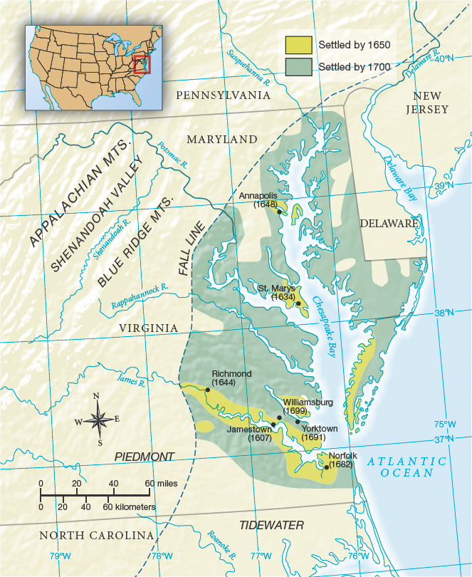
MAP 3.1 CHESAPEAKE COLONIES IN THE SEVENTEENTH CENTURY
This map illustrates the intimate association between land and water in the settlement of the Chesapeake in the seventeenth century. The fall line indicates the limit of navigable water, where rapids and falls prevented travel farther upstream.
Question
3.3
aBjg6wFfrX1OOr+osN6CExOZR/HK0fKhiYuXjTvX2KK+UDVKx4dEj4+esux1MHu9eZzFvPkASShxviMrbhXAcHh2mffoiJhFE2aSqqVLmG8PKhempQI8E7rfYrWycDoaMiiUq7ydfO9PzTm8SmKk1JDJHi68wutJTrUgm/mLo7joi8QSa8pc/quf5ZSHrZrD4Fa3ywN3k04iKs/G7vGU2B1WTTUdDINeQ/o8IeKc/aiC3yeXwCBf5Nhfl3hsFG+gX6d7kdR/S44W4Ax2qpiJ0rN+CLXE5PFcKkVfH7FSnWSerRszuEtEKZTZx16uPehUtuMr+z6xTnWTslw2hpu+6g==
Question
3.4
2nZG+xvoAboyX3Bad+mSNYDrULrZsztR8aQ9GfbrNOcytI8Oz1qhF2Y/EIKUaiDM12us6IyYZ9XUM01FpGF+g4zi0HwWRsfDM62Z3yU+kFzwtZ+91TEgRr9iltVXq448+k191qT3NsHWmgBHUWoCUlbGjsdaU+rd6pcphlAmnKdGVI93quvPR2JxnnyvQQll71we+POGzCHNdKR60f09Nuxznqlwks8K8Ml80vtLdwHES+1rBjpZYt6JK5i5EQUc0WmP99UAlrVYnzp7f+ZWxUm3E0lJqkZmItd0EncezwLscmQN