How Remote Sensing Works
327
Electromagnetic Energy, the Remote Sensing Process,
Spectral Reflectance, NDVI, Digital Imagery,
and Color Composites
remote sensing the process of collecting information related to the electromagnetic energy reflected or emitted by a target on the ground, using a device a considerable distance away from the target on board an aircraft or spacecraft
When you use Google Earth to get an overhead view of your house, Google had to get those images from somewhere, but a number of steps must be taken before that image of your house can be acquired and finally turned into the picture you can view on the computer screen. In Chapter 9, we discussed how what’s really being captured via remote sensing is reflected light—this is a form of electromagnetic energy, and a sensor is measuring the amount of energy that reflects off a target on the ground. In addition, in remote sensing the sensor will be on an airborne or spaceborne platform that will be a considerable distance away from a target on the ground below. Some remote sensing devices measure other forms of energy emitted by objects on the ground (heat, or the thermal properties of items, for instance). This chapter, however, focuses on measuring the reflection of electromagnetic energy.
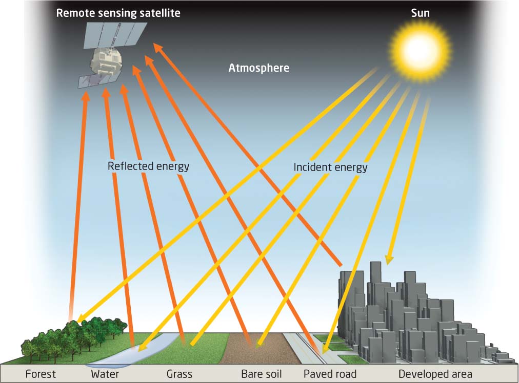
If remote sensing measures the reflectance of electromagnetic energy, there needs to be a source for that energy. Luckily, we have one nearby—the Sun is the source. The Sun is almost 93 million miles away from Earth, and sunlight takes about 8.3 minutes to reach Earth. This solar energy radiates through space at the speed of light (almost 300 million meters per second), and passes through and interacts with Earth’s atmosphere before it reaches Earth’s surface. The energy then interacts with objects on Earth’s surface, and some of the energy is reflected back into space. That reflected energy passes back through the atmosphere, and is picked up and recorded by a sensor, either on an airborne or spaceborne platform (Figure 10.1).
These measurements made at the sensor are being captured as remotely sensed data. Thus, the remotely sensed information you see on things like Google Earth is actually the reflection of energy off targets on the ground that has been measured, processed, and turned into imagery to view. We’ll go through each of these stages in more detail to see how you can start with energy from the Sun and end up with a crisp satellite image of a target on the ground (also see Hands-on Application 10.1: Viewing Remotely Sensed Imagery Online for some finished products of remote sensing).
328
!geo! HANDS-ON APPLICATION 10.1
Viewing Remotely Sensed Imagery Online
An excellent tool for viewing different types of remotely sensed data in your Web browser (without using a separate program like Google Earth) is Flash Earth. As the name implies, make sure you have Flash installed on your computer, then open your Web browser and go to http://www.flashearth.com to get started. When Flash Earth starts, you can pan around Earth and zoom in on an area (or search by location). To get started, look at the United States and search for New York City. Zoom in on Manhattan, and examine what types of imagery become available from the Map Source options—you can select from Bing Maps or Yahoo! Maps imagery. The closer you zoom in, new imagery will load for different scales.
Expansion Questions:

Question
6stexdpvtSu4wmUl+5cVtVikfHEUk6OsW7+Azv7EtTtM6Vo79lBJxZIa32xpb9lZThIVtg6mttmHNTe2oh3STTm0VAh7+EjbNKeooZvcD+u5xEBjdUAD8vMv5d2xahc5nMVCrBLX0Zz5mYaT98VpQNaBrszyydApFaUGGrDtiTzhCTXQ53o9pok1BPetgylLm2G1xBfDfU8=-
Question
Jy9VORgVMs52jGlO2Aj0DQkh2VWt7RWPoPUfApach4rC/wySEXSv6MVIQOzHAXQc3BV/Yo3WSgZRZnR5weMndA3XFHicxengDJfOo9UGeggR+qN1YN95cZREHmXUw/ve6uT2scK1M8tWdFtIT0KNSLQLo3jOBJsj/UAIh7nVukkic0HiWQpE84J6Hj3xG6LLMpc6D9HnILrqY2x2sdYVgvcoENdVAZKr4QjPrj6GfB1o74ayohs1PHHn180I/UK8VRga8gqehdXzoi1ncRTA145VzNaUsSZyIpRa+jVyviVxonN5KRAjPXkyIe95drG6M5d4JUZl1nuT4zHA
329
Note that this process (and this chapter) describes passive remote sensing—where the sensor doesn’t do anything but simply measure and record reflected or emitted energy. In active remote sensing, the sensor generates its own energy, casts it at a target, and then measures the rebound, echo, or reflection of that energy. Radar is a good example of active remote sensing—a device on a plane throws radar waves (microwaves) at a target, those waves interact with the target, and the device measures the backscatter of the returning radar waves. LIDAR (see Chapter 13) is a similar kind of active remote sensing technique that shoots a laser beam at a target and uses the beam’s reflection to measure the heights of objects on the ground.