11.1 How Do Remote Sensing Satellites Collect Data?
geostationary orbit an orbit in which an object follows precisely the direction and speed of Earth’s rotation and is therefore always directly above the same point on Earth’s surface
Remote sensing satellites are placed in a specific orbital path around Earth. One type of orbit used in remote sensing is geostationary orbit, in which satellites rotate at the same speed as Earth. Since a geostationary satellite takes 24 hours to make one orbit, it’s always in the same place at the same time. For instance, although it’s not a remote sensing system, satellite television utilizes a geostationary orbit—the satellite handling the broadcasting is in orbit over the same area continuously, which is why a satellite reception dish needs to be always pointed at the same part of the sky. Likewise, the WAAS and EGNOS satellites we discussed in Chapter 4 are in geostationary orbit so that they can provide constant coverage to the same area on Earth. There are some remote sensing satellites that use geostationary orbit to always collect information about the same area on Earth’s surface (such as the GOES series of satellites used for obtaining weather imagery).
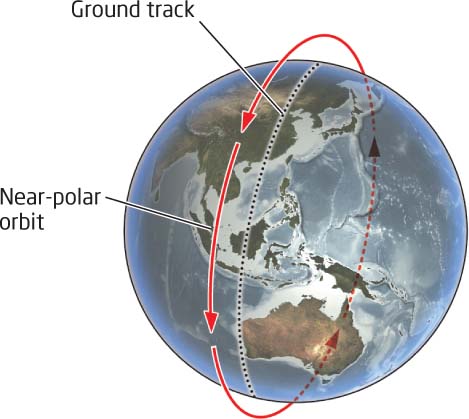
near-polar orbit an orbital path close to the North and South poles that carries an object around Earth at an unvarying elevation
Many remote sensing satellites operate in near-polar orbit, a north-to-south path wherein the satellite moves close to the North and South poles while it makes several passes a day about Earth. For instance, the Landsat 7 satellite (a U.S. satellite that we’ll discuss in more detail in a few pages) completes a little more than 14 orbits per day (each orbit takes about 99 minutes)—see Figure 11.2 for Landsat 7’s near-polar orbit. Also, check out Hands-on Application 11.1: Examining Satellite Orbits in Real Time (page 358) for two methods of tracking satellite orbits in real time.
358
!geo! HANDS-ON APPLICATION 11.1
Examining Satellite Orbits in Real Time
Think about all the jobs that satellites are doing—communication, satellite TV, weather monitoring, military applications, and GPS—and then add remote sensing to that list. When you consider how useful these tasks are, you can see the need for many, many satellites in orbit.
JSatTrak is a very cool program that you can use to view (in real time) the locations of numerous satellites (including remote sensing ones). JSatTrak can be downloaded from http://www.gano.name/shawn/JSatTrak. When JSatTrak opens, you can access a list of satellites via the Windows pull-down menu and by choosing Satellite Browser. A list of available satellites will appear. (Many of the remote sensing satellites described in this chapter and in Chapter 12 can be found by expanding the Weather and Earth Resources option, then selecting Earth Resources.) When you drag the name of a satellite from the list to the Object List window on the right side of the screen, the orbit track and current location of the satellite will be shown in the display window. Check out Landsat 7 and Terra, and also look for others. JSatTrak has many features that you can explore (such as the 3D Earth Window for looking at satellite tracking).
NASA also provides an online satellite tracking tool called J-Track 3D that allows users to track satellite positions in real time, using only a Web browser and Java. This utility is available here: http://science.nasa.gov/realtime/jtrack/3d/JTrack3D.html. It will plot the positions of all satellites currently being tracked as a series of dots around Earth. Selecting a dot will identify which satellite it is and show its orbital path.
Expansion Questions:

Question
E4bVPXaORN+3Fcl5xZFZfISApQE1KIn9sOi7ukKMqj2YAe14fUbIDyqpoNqdqVoi3q1iYXJ88cJ9lf6qqp0lEuDRmIYjM7Kzsgh0pGd8BrI0ybU90D8RE6CclZMm0ent2FiXurNyhdjzW4K7NfsgEYSULY+R/dd8C8Rj+QCgCJsOn7PqbGS8hzEKgIs=-
Question
diE7NMRAvZPtY37oFaKzJy939BByCgtbWkzoyEgToRTDSa6dcV2MUN7R0K7LBM3jvo8dQ77b7Kl6rqvZMZe58oK8RjDFnnfypdPZmeZ/TjnczyVNUy/hBwDgI5i1kTxxEFUS0FgAxoP0XhZM9DLgHKTvBlNX6NAS6jIFxaRO1s5j8NPZ+2RMutgUX0kf03tAAHs4i9gRtQcjl1pct/URu+hVMtHiLPCm/apCtbLEEWzzMFpta1BSiTnm2Wv02isSHFjVptl1/5iYUm1TMOzFL5ziDrP+bkvfbOVLSOkDPfmbb0xXnl9yOhMLh5gkhcDU59EM5vqsLKsHxQbX7gHu5Tv+P0nm87ba01tKygwIY9r1zWVsB6vgsqjd3baXKqGpZNcTKq9VnSVU1H428TRbRQ==
swath width the width of the ground area the satellite is imaging as it passes over Earth’s surface
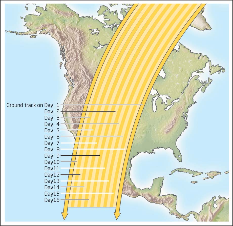
While a satellite in continuous orbit passes over Earth, it will be imaging the ground below it. However, during an orbit, a satellite can only image a certain area of ground at one time—it can’t see everything at once. The swath width is the measurement of the width of ground the satellite can image during one pass. A Landsat satellite’s sensor has a swath width of 185 kilometers, meaning that a 185-kilometer-wide area on the ground is imaged as Landsat flies overhead. As satellites orbit, Earth is rotating beneath them, meaning that several days may elapse before an orbital path (and thus, the swath of ground being imaged) takes a satellite over nearby geographic areas. For example, a Landsat satellite may pass over the middle of the United States on Day 1 of its orbit, pass hundreds of miles to the east on Day 2, and not return to the path next to the first one until Day 8 (Figure 11.3).
sun-synchronous orbit an orbital path set up so that the satellite always crosses the same areas at the same local time
After a certain amount of time, the satellite will completely pass over all areas on Earth and again resume its initial path. For instance, each one of the Landsat satellites is set up in an orbital path so that it will pass over the same swath on Earth’s surface every 16 days. Thus, when Landsat’s orbit carries it to the swath where it’s collecting imagery of your current location, it will be another 16 days before it’s able to image your location again. A sun-synchronous orbit occurs when a satellite’s orbit always takes it over the same swath of Earth’s surface at the same local time. As a result, images collected from the satellite will have similar sun-lighting conditions and can be used for comparing changes to an area over time. For instance, Landsat 7 has a Sun-synchronous orbit, allowing it to cross the Equator at the same time every day.
359
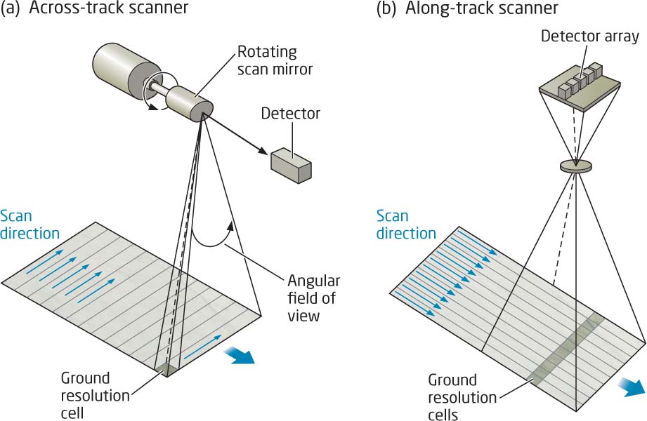
along-track a scanning method using a linear array to collect data directly on a satellite’s path
across-track a scanning method using a rotating mirror to collect data by moving the device back and forth across the width of the satellite’s swath
The sensors onboard the satellites have different ways of actually scanning the ground and collecting information in the swath being imaged. In along-track scanning, a linear array scans the ground along the satellite’s orbital path. As the satellite moves, the detectors in the array collect the information from the entire swath width below them. This type of sensor is referred to as a “pushbroom.” Think of pushing a broom in a straight line across a floor—in this case, the broom itself is the sensor, and each bristle of the broom represents a part of the array that senses what is on the ground below it. A second method is an across-track scanner; here, a rotating mirror moves back and forth over the swath width of the ground to collect information. This type of sensor is referred to as a “whiskbroom.” Once again, think of sweeping a floor with a broom, swinging the broom back and forth across a path on the floor—the broom is the sensor, and the bristles represent the detectors that collect the data on the ground below them. Satellite systems usually use one of these types of sensors to obtain the energy reflectance measurements from the ground (see Figure 11.4 for examples of the operation of both sensor types).
360
!search! THINKING CRITICALLY WITH GEOSPATIAL TECHNOLOGY 11.1
What Effect Does Satellite Remote Sensing Have on Political Borders?
When imagery is acquired by satellite remote sensing for any part of the globe, the satellite sensors effectively ignore political boundaries. After the 2010 earthquake in Haiti, imagery of the country was quickly acquired by satellites and made available for rescue and recovery efforts. When satellite images of nuclear facilities in North Korea or Iran are shown on the news, the satellite’s sensors were able to image these places from orbit. Satellites can acquire global imagery of events ranging from the 2012 Olympics in London to parades in Beijing; and in all cases, the political boundaries of these places are being ignored by the “eye in the sky” that is looking down from Earth’s orbit. Satellites are not restricted by “no-fly zones” or other restrictions involving a country’s airspace, and they are capable of acquiring imagery from nearly everywhere. Given these imaging capabilities, what effect does acquisition of images via satellites have on political borders? There are many areas that can’t be approached from the ground without causing international tensions, but these same places can easily be viewed from space. How are political boundaries affected by these types of geospatial technologies?
361
EROS the Earth Resources Observation Science Center, located outside Sioux Falls, South Dakota, which serves (among many other things) as a downlink station for satellite imagery
After a satellite’s sensors have collected data, the data need to be off-loaded from the satellite and sent to Earth. Because data collection is continuous, this information needs to get to people on the surface so that it can be processed and utilized as it becomes available. The Earth Resources Observation Science (EROS) Center located outside Sioux Falls, South Dakota, is one of the downlink stations in the United States that receives data from numerous remote sensing satellites. Satellite data can be directly sent to a receiver at a station or transmitted to other tracking and data relay satellites, which then send the data to Earth. Once received on the ground, the data can be processed into imagery.