Studying the Environment from Space
386
NASA’s Earth Observing System Program,
Terra, Aqua, Aura, and Viewing and
Examining EOS Imagery
Climate change and global warming have become hot-button issues in today’s world, affecting everything from a country’s energy policies, to its economy, to its citizens’ choices of homes and vehicles. The study and monitoring of the types of environmental processes that affect the land, oceans, and atmosphere occur on a global scale, and a continuous flow of constant information is needed. Monitoring changes in global sea surface temperature is going to require information captured from the world’s oceans on an ongoing basis. In order to acquire information about the whole planet in a timely fashion, remote sensing technology can be utilized. After all, satellites are continuously orbiting the planet and collecting data—they provide the ideal technology for monitoring Earth’s environmental conditions and changes. There are a lot of other remote sensing satellites up in orbit that are doing their jobs besides Landsat and the high-resolution satellites we discussed in Chapter 11. In fact, there’s an entire set of science observatories orbiting hundreds of miles over your head that are dedicated to continuously monitoring things that may be critical to the planet’s health, like sea surface temperature, the condition of glaciers, trace gases in the atmosphere, humidity levels, and Earth’s heat radiation.
EOS NASA’s Earth Observing System mission program
The Earth Observing System (EOS) is a series of remote sensing satellites operated and maintained by NASA. Each satellite’s capabilities are dedicated to an aspect of environmental monitoring or data collection related to Earth’s surface, oceans, atmosphere, or biosphere. These EOS satellites often have coarse spatial resolution (for instance, some instruments have a spatial resolution of 1000 meters), but they consequently have a much larger swath width—and thus the ability to “see” an area up to 2300 kilometers across. Their instruments are also set up to monitor very specific wavelengths tied to the purpose of their particular sensors. Their revisit times are usually relatively short (like imaging the whole Earth in a couple of days) to provide constant data streams of observation data about whatever environmental system they’re examining.
387
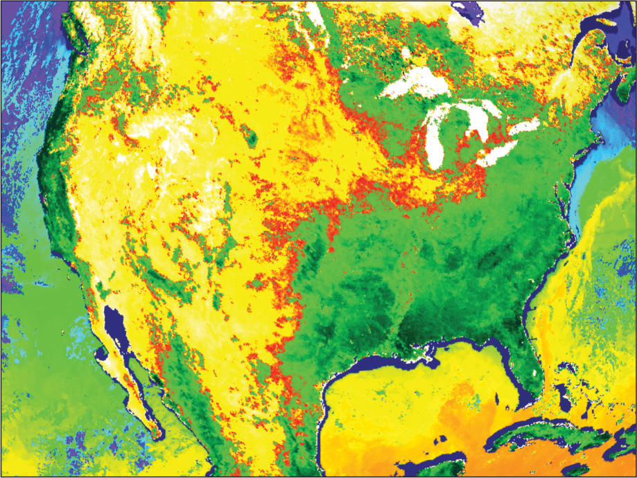
There are a lot of different uses for EOS data, and many different products are derived from the information the satellites provide. This chapter can’t hope to cover all of them; we can just demonstrate some sample applications. See Figure 12.1 for an example of the kind of data and imagery that can be collected by EOS—the image was collected by a sensor onboard an EOS satellite over eight days in April 2000. It shows the health of vegetation (the “greening” of springtime) in North America and the sea surface temperature of its surrounding waters. The overall mission of EOS is to examine global environmental phenomena to advance knowledge and understanding of Earth’s systems as a whole. The EOS missions were begun during the 1990s—there are several ongoing EOS missions, with more planned for the future, with three key satellites being Terra, Aqua, and Aura.