13.1 How Can Terrain Be Represented?
topographic map a map created by the USGS to show landscape and terrain as well as the location of features on the land
DRG a Digital Raster Graphic—a scanned version of a USGS topographic map
A common (and widely available) method of representing terrain features is the topographic map. As its name implies, a topographic map is designed to show the topography of the land and the features on it. Topographic maps (commonly called “topo maps,” for short) are published by the USGS (United States Geological Survey) and are available at a variety of map scales. A common topographic map is a 1:24000 topo quad (also referred to as a 7.5 minute topo map, insofar as it displays an area covering 7.5 minutes of latitude by 7.5 minutes of longitude). Topo maps are also available in smaller map scales, such as 1:100000 and 1:2000000. Topo maps are available in a digital format as a DRG (Digital Raster Graphic). DRGs are scanned versions of topo maps that have been georeferenced (see Chapter 3) so that they’ll match up with other geospatial data sources.
GeoTIFF a graphical file format that can also carry spatial referencing
collar the white, information-filled border around a topographic map
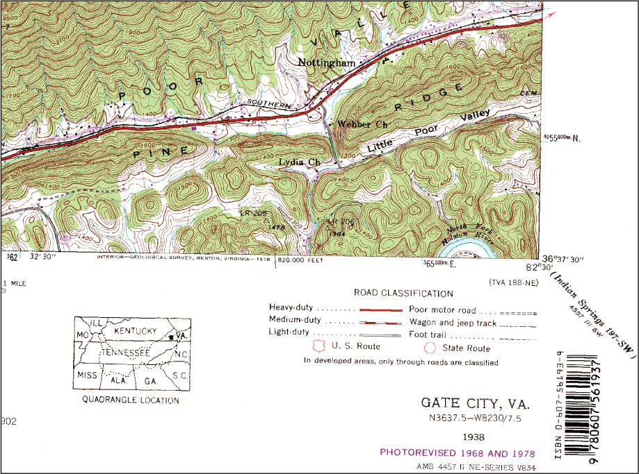
Usually, DRGs are available in GeoTIFF file format (see Chapter 7 for more information about TIFFs), which allows for high-resolution images while also providing a spatial reference. When a DRG is used as a layer in geospatial technology, it contains information to allow it to match up with other data layers. A topographic map (and thus, a DRG) also contains a lot of data (including the scale, the dates of map creation and revision, and similar information) in the white border that surrounds the map. This border is referred to as the map’s collar. A topographic map will either come with all of this information intact, or in some cases, the collar will be removed and you will have only the map itself. See Figure 13.2 for an example of a DRG complete with collar.
419
contour line an imaginary line drawn on a map to connect points of common elevation
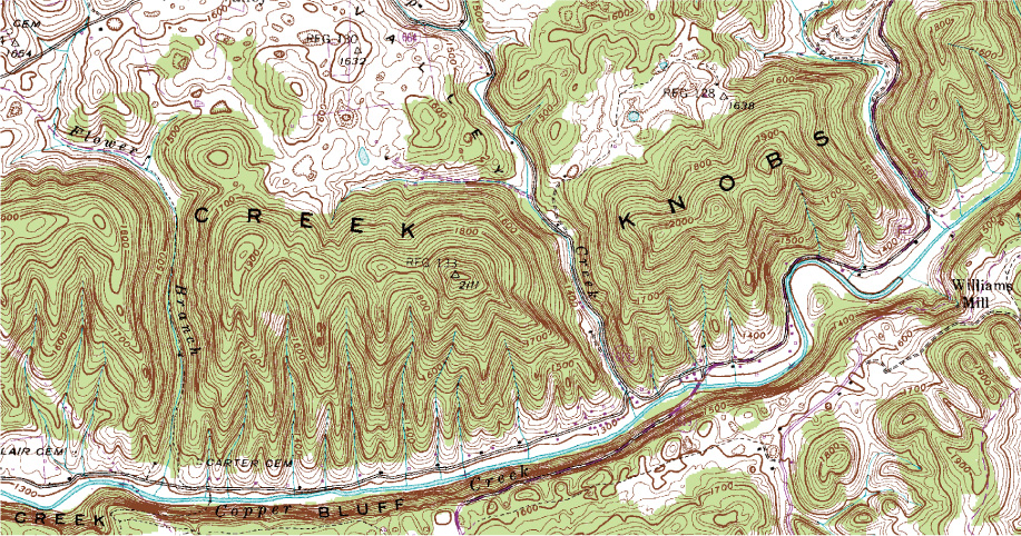
Topographic maps (and thus, DRGs) model the landscape through the use of contour lines—imaginary lines drawn on the map that join together points of equal elevation (Figure 13.3). A particular elevation on the surface is represented by a contour line drawn on the map. However, because elevation is really a continuously variable phenomenon, it’s often difficult to represent every change in elevation (such as from eight feet of elevation to ten feet of elevation) without overloading the map to the point of uselessness because it’s filled to the breaking point with contour lines. Thus, contour lines are drawn a certain elevation distance apart (say, a new contour line for every 50 feet of elevation).
420
contour interval the vertical difference between two adjacent contour lines drawn on a map
This elevation (or vertical) difference between contour lines is called the contour interval and is set up according to the constraints of the map and the area being measured. In general, a wider contour interval is selected when mapping more mountainous terrain (since there are numerous higher elevations), and a narrower contour interval is used when mapping flatter terrain (since there are fewer changes in elevation and more details can be mapped). Small-scale maps (see Chapter 7) tend to use a wider contour interval because they cover a larger geographic area and present more basic information about the terrain, whereas large-scale maps generally utilize a narrow contour interval for the opposite reason (they show a smaller geographic area and thus can present more detailed terrain information). DRGs (and their contour lines) are frequently used as data sources within geospatial technology (they are often overlaid with other layers in GIS). See Hands-on Application 13.1: Digital Raster Graphics Online for a method of obtaining DRGs online.
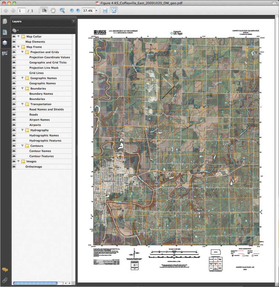
US Topo a digital topographic map series created by the USGS to allow multiple layers of data to be used on a map in GeoPDF file format
While DRGs remain available (and many software programs such as ArcGIS give you the capability of examining “seamless” digital topographic maps), they (and the topographic maps they’re derived from) are no longer being produced. Instead, the “next generation” of digital topographic maps is the US Topo series. The US Topo maps are delivered in 7.5 minute quad sections, but in GeoPDF file format (see Chapter 7), which allows multiple layers of data to be stored on the same map—these layers can be turned on and off. US Topo maps include contours, recent transportation features (roads, railroads, airports), transportation names, hydrography, boundaries, and orthophoto images, all as separately accessible layers (see Figure 13.4 for an example of a US Topo map), as well as the full collar of information (which can be displayed or removed as a separate map layer).
!geo! HANDS-ON APPLICATION 13.1
Digital Raster Graphics Online
If you need to look up features on a topographic map, there’s no need to wade through a map library filled with topo quads of all sizes and scales. USGS topo maps are made available online as DRGs. The Libre Map Project is a great online resource for 1:24000 DRGs. Open your Web browser and go to http://libremap.org, then select the Data tab. From there, select your state. A new menu will appear and let you first search for specific features (selecting Florida for the state will allow you to search for Walt Disney World as a feature) and then download the DRG that contains Disney World.
Expansion Questions:

Question
BXrq5g3y/x8kuXq076jTnqTxawRWUDIZqYb92Wwvq85EfbLHsRSCMUJLjyj1pAkQAsyaKCKs53dOuTmSCMlCsY/4D36VVp/n7ABEG9eEp8y6Y/spPnrPiIy/jyHjliP7WiSoMEnwINqCy8XeJeWOws3A5drEGEttVhs2gtuQ6avp7yK5l/3wFPUwUo/n+AsPIe2362cagHeTdZeIt6zFhiVn/rUrAHCNLMx/X39h3qsIMJe8bWPQ3ViQK8ZwrT2hkEaj+CZyAryCOjjKdhoctLh8WEhKctGpFyljWpbMTXLH8lOeaeXPPTbzMyZSEiyRyViYFYp5mL7GkkvstEPdCgHY/l+/k1TZEANxoDwrGECiEBIV4b8XBWh4iRasOyrhz5VoTeHOS0RKmwd3Zgac04XlakRq7TlxnCVdniGEMpudz3fBpjw+no0583PR7RsE5phMp2UrlURanjOsL2AxUJ9vj0ygX+jpzMJLOj2/kAAQWgCJyxTJ3h3ZI5eDMHKyML5aOjGnfp7ALljyKSwe7gGGEy0OUVRv0i4joTBn5xOWYJhGU2NjRODP+Vng8ivtEkhjMFYMp+V1mks6emdx1xPC2eo=-
Question
Og1KM+SLP3Bd2dfZPCMgqffyn2I7HUHCRps5ekbhWPUu/49Gu4gfYBGGEv7MsvsQMP9Iz2r2xx0J1F68PzXhYjVhJJefYFTDzr0nMWG7zw3jdTD6mpUUv07Ng/mM+y2q6AHBWvEasualOrwW/PFaZRzvHV5p3gWwi9NIBA2vbY6MeCM2vCZwB+Q5Vk4hpnQW0ZpQaFhRYSFYP4eeZQTtVzD9j6C65SUXClyTjquq1Kw7ItjN -
Question
LhwylGUKqBf8oNGOXxYYrKLqWI97Kx2ZjJM6g1WuToChxmDvNUUA1S+8PvzyObgtNJCdOErowG6E8gTguJQjsEu9tEb70dpepO/VQHBJVgvnkJ/IbQhAO46f6dhlMGNseg5AYpFIZ/sJewes6PwmoY9JUF1iqxPhf+W8/mOLWDyHin6c6fyTN1ddHP5T5eu84DCJie6JhFgc+gicYSHZOD/gMme5N01MltxaS5aDIiZnFIwZWHL2a6J+1aagO6HY
421
The USGS produces over 100 US Topo maps per day, and it currently covers the entire United States on a three-year update cycle. US Topo maps are available for free download from the USGS (see Hands-on Application 13.2: US Topo Maps as GeoPDFs for accessing and utilizing US Topo maps), and older topographic maps are also being converted to GeoPDF format for free download. Although topographic maps in all of their incarnations can represent terrain with contours, there are more detailed methods of digital terrain modeling available through geospatial technology.
422
!geo! HANDS-ON APPLICATION 13.2
US Topo Maps as GeoPDFs
To see what US Topos are available for download in GeoPDF file format, open your Web browser and go to http://nationalmap.gov/ustopo/index.html, the main Website for US Topos. Click on the link for Download Maps (Map Store); this will take you to the current download site (at the time of this writing, it was the USGS Store) to access the Map Locator.
At this point, you can first type the name of a place to search for available US Topos and then choose to download the maps as free GeoPDF files. For instance, search for East Lansing, Michigan, then place a marker in the box that contains East Lansing. Click on the marker to see the available download options, and download the most recent 7.5 minute US Topo for East Lansing. A zip file will be downloaded to your computer containing the GeoPDF. In order to work with all the features of a US Topo, you should download and install the TerraGo Toolbar plug-in, so make sure that you do so prior to opening the PDF file. The TerraGo Toolbar can be downloaded directly from here: http://usgs.terragotech.com. With the GeoPDF downloaded and the toolbar installed, open the PDF file and examine the various layers available within the US Topo.
Expansion Questions:
-
Question
T1SZZxtg8MJtHVM6Qd9K8cNT1RjjQi+vyNuazZKBddemJUVpQKXP9+259a4+SmPMxfc9AGCk2BO1IOY5I/uVOtkWcVghVDwHKYE/DAAC57joZxqhpkq5aUbIX4+btBYWHH4qe/w8VPXCf3JM/+9MNrrGkRAMMC0GjRO0/pEQZf/6KdzJ4NSVpNIU6UghMR5CzsLZ3YPY24Saj2x9M1JQXQPfaKHY6MYJqq3BwbDcsT2g9esyCvPYbtVAiZiSNTz6CeP+p3Me0qCT0xMZ15ay4dwqLvjkMlorAyvYLuQB1wR+spQFzzezql5UXg70QWXRFbtYPl9KuZKjGJ+g -
Question
CIVkAP9fXC7u8gS3FCW+FywdCuvFbXqnIO7b3qtNNH7WZPeh0tFVpjrxmZGr9JhuQf+r/V3/K01edomqUQYJoqquT+IxW6nZ0A/JWwERCTGMvtlAIJylTGK4AB27GjdCluftXTM4whsdCZoootYo4Zhj8rNcoPDITsis+w== -
Question
5TjJLfqOZE556Ubz+E/lyzxBELUQc+jQbxC9Kuv/qD/AEqNa7unltNyqW0xvWgTXpls/BGKwcsTRqFSHLYaXFqxbr1SAlps+EbbClOnI0pcaSoJ5GW8tRg==
!search! THINKING CRITICALLY WITH GEOSPATIAL TECHNOLOGY 13.1
If Everything’s Digital, Do We Still Need Printed Topo Maps?
A similar question was raised back in Chapter 2: If all of the latest USGS topographic map products are available digitally and in easily accessible formats, is there still a need to have printed copies (at a variety of map scales) on hand? Do surveyors, geologists, botanists, archeologists—or any other professionals who require topographic information for fieldwork—need to carry printed topo quads with them? Is there a need for geographers to have printed versions of several quads when seamless digital copies (which can be examined side by side) are so easily available? Are there situations in which a printed topo map is necessary?