13.2 How Can Geospatial Technology Represent Terrain?
DTM a representation of a terrain surface calculated by measuring elevation values at a series of locations
two-and-a-half-dimensional (2.5D) model a model of the terrain that allows for a single z-value to be assigned to each x/y coordinate location
three-dimensional (3D) model a model of the terrain that allows for multiple z-values to be assigned to each x/y coordinate location
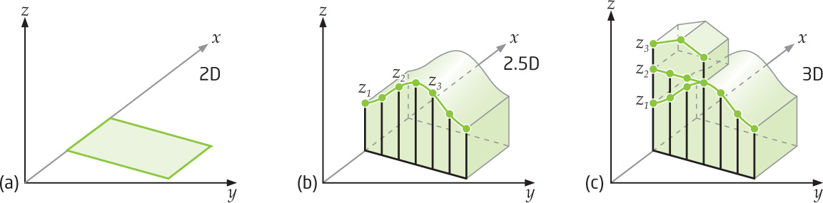
In geospatial technology, terrain and landscape features can be represented by more than just contour lines on a map. A Digital Terrain Model (DTM) is the name given to a model of the landscape that is used in conjunction with GIS or remotely sensed imagery. The function of a DTM is both to accurately represent the features of the landscape and to be a useful tool for analysis of the terrain itself. The key to a DTM is to properly represent a z-value for x and y locations. With a z-value, the model can be shown in a perspective view to demonstrate the appearance of the terrain, but this doesn’t necessarily make it a three-dimensional model. In fact, a DTM is usually best described as a two-and-a-half dimensional model. In a 2D model, all coordinates are measured with x and y values, without a number for z at these coordinates. In a two-and-a-half-dimensional (2.5D) model, a single z value can be assigned to each x/y coordinate as a measure of elevation at that location. In a full three-dimensional (3D) model, multiple z-values can be assigned to each x/y coordinate. Most DTMs have one elevation value measured for the terrain height at each location, making them 2.5D models (Figure 13.5).
423
TIN Triangulated Irregular Network—a terrain model that allows for non-equally spaced elevation points to be used in the creation of the surface
An example of a type of DTM that’s used in terrain modeling is a TIN (Triangulated Irregular Network), in which selected elevation points (those that the system deems the “most important”) of the terrain are used in constructing the model. Points are joined together to form nonoverlapping triangles, representing the terrain surfaces (see Figure 13.6). While TINs are often used in terrain modeling in GIS, another very widely used type of digital terrain model is the DEM.
424