15.3 Who Is Involved with Geospatial Technology?
OGC the Open Geospatial Consortium, a group involved with developing new standards of geospatial data interoperability
There are numerous “power players” in the geospatial world—we’ve already discussed the role of companies like Microsoft, Google, Esri, and DigitalGlobe, and a growing number of government agencies, including NASA, NOAA, and the USGS, in generating and providing geospatial data and infrastructure. Other federal government agencies, including the EPA (Environmental Protection Agency) and the NGA (the National Geospatial-Intelligence Agency), play important roles in applications of geospatial technologies. Many state and local agencies utilize GIS, GPS, or remotely sensed data through city planning, county auditors’ offices, or county engineers’ offices. Also, the Open Geospatial Consortium (OGC) is dedicated to developing new standards of geospatial data interoperability.
493
AAG the Association of American Geographers: the national organization for the field of geography
ASPRS the American Society for Photogrammetry and Remote Sensing: a professional organization in the geospatial and remote sensing field
URISA the Urban and Regional Information Systems Association: an association for GIS professionals
NCGE the National Council for Geographic Education: a professional organization dedicated to geographic education
OhioView a research and education consortium consisting of the state universities in Ohio, along with related partners
AmericaView a United States national organization dedicated to remote sensing research and education
StateView the term used to describe each of the programs affiliated with AmericaView in each state
There are also several prominent professional organizations in the geospatial field. The Association of American Geographers (AAG) is the national organization for geographers in all fields, whether physical, regional, cultural, or geospatial. Boasting several thousand members, AAG is a key organization for geographers, hosting a large annual national meeting, multiple regional branches, and publishing key geographic journals. The American Society for Photogrammetry and Remote Sensing (ASPRS) is a major professional organization dedicated to remote sensing and geospatial research. ASPRS publishes a prominent academic journal in the field, and hosts national and regional meetings that are well attended by geospatial professionals. URISA (Urban and Regional Information Systems Association) sponsors numerous conferences and publications dealing with the academic, professional, and practical aspects of GIS. Finally, but of equal importance, the National Council for Geographic Education (NCGE) is a nationally recognized organization of educators dedicated to promoting geographic education through conferences, research, and journal publications.
There are many ongoing research and educational initiatives dedicated to furthering geospatial technology and its applications, as well as to improving and fostering access to geospatial data and tools. For example, OhioView, created in 1996, is an initiative dedicated to remote sensing research and educational programs in Ohio. Part of OhioView’s efforts led to the free distribution of Landsat imagery (where previously a single Landsat scene used to cost $4000). OhioView serves as a consortium for remote sensing and geospatial research, and is composed of members from each of the state universities in Ohio, along with other partners. With all of these statewide affiliations, OhioView serves as a source of many initiatives within the state, including educational efforts.
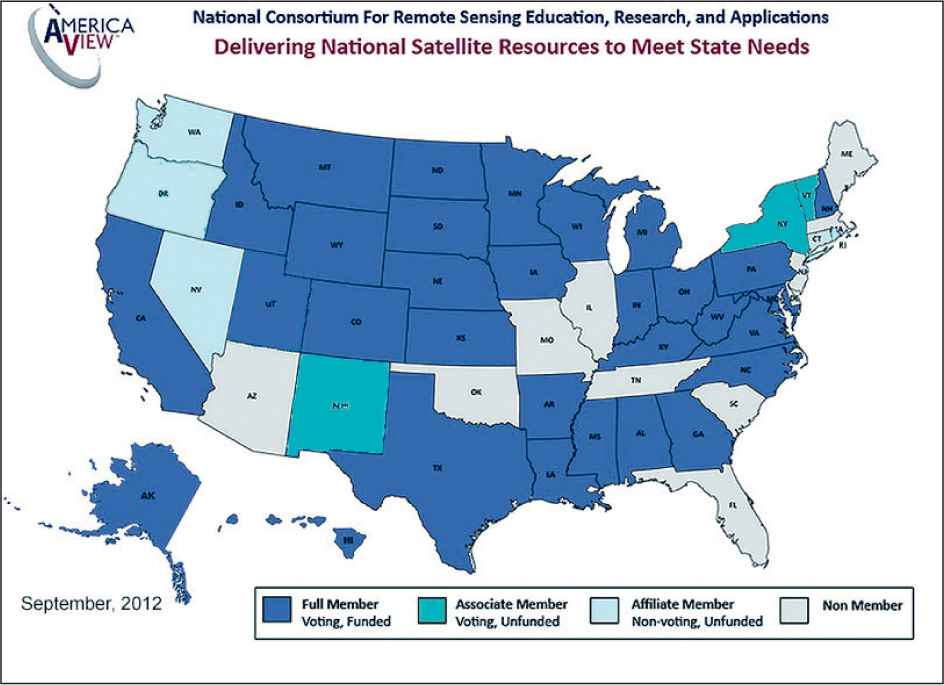
This type of statewide consortium may have originated with OhioView, but it has expanded to a national program called AmericaView. Administered in part by the USGS (and set up as a 501(c)(3)), AmericaView aims to spread remote sensing research and promote educational initiatives all over the United States (Figure 15.6). Many states have developed a StateView program similar to OhioView (for instance, there’s VirginiaView, WisconsinView, TexasView, and so on), with the eventual goal of having a complete set of 50 StateView programs. Each StateView is composed of state universities and related partners from that state, and offers various geospatial services and data (such as Landsat imagery and other remotely sensed data) for that state. For instance, OhioView servers permit the free download of Ohio Landsat data from their multiyear archive. Similarly, WisconsinView provides fresh MODIS imagery of Wisconsin every day, and the other AmericaView member states make many data products freely available (such as high-resolution aerial photography and Landsat imagery). In addition, TexasView offers free access to remotely sensed images, as well as providing links to GIS data of Texas. See Hands-on Application 15.7: AmericaView and the StateView Programs to further investigate the resources available through the various StateView programs.
494
!geo! HANDS-ON APPLICATION 15.7
AmericaView and the StateView Programs
To see if your state is part of the AmericaView consortium (and to also see the current version of the program’s membership), open your Web browser to the interactive map located at http://www.americaview.org/membership-map. If it is a full member, click on the state to bring up the contact info and check out the specific StateView’s Website (that is, MichiganView’s Website or VirginiaView’s Website) to see who that state’s members are, and what type of data and services they provide. If your state’s not (yet) a full member, take a look at some of your neighboring states and see what they offer as a StateView program.
Expansion Questions:

Question
LI7yG8idljlGpNThhJIC/byMDHqjL4o/22fwSKPxuikJSmd0Yo+G3QC2VJjtLdgwUIXdOkvwgtH+pF5Obo2e2XI9RcI=-
Question
APdCQKj7zC3RbTXprZOmo4O9rEX5rfQl/fKkBeV2+XHG9ApZLqMrVN3BNDeH7CpbmIM2uaUQW842SSF9+U5PaYC91zOH6KY8stE2HPVBBrQg9Kz1Dd40t9AftKDgg29EHDKoh0alxodvb0OQiJchOTOXBGHzmSaQN06aKCfq6ak7bnSulKIIGX1yWpMzJyHl6qJSzAg4aUt1DowLUb5qiwKOZe53yswUEhjFalOIMv3+XuaIFQs3iK9Xd/uk4lYhzgkznA==