1.3 What Is Geospatial Data?
Geospatial data (also often referred to as spatial data) refers to location-based data, which is at the heart of geospatial technology applications. This ability to assign a location to data is what makes geospatial technology different from other systems. You’re using geospatial concepts anytime you want to know “where” something is located. For instance, emergency dispatch systems can determine the location you’re calling from if you make a 911 call. They also have access to information that tells them where the local fire stations, ambulance facilities, and hospitals are. This type of information allows the closest emergency services to be routed to your location.
When the data you’re using has a location that it can be tied to, you’re working with geospatial data. This isn’t just limited to point locations—the length and dimensions of a hiking trail (and the locations of comfort stations along the trail) are examples of real-world data with a spatial dimension. Other kinds of data, like the boundaries of housing parcels in a subdivision or a satellite image of the extent of an area impacted by a natural disaster would fall under this category. Geospatial technology explicitly handles these types of location-based concepts.
non-spatial data data that is not directly linked to a geospatial location (such as tabular data).
However, not all of the data in the world is geospatial data. For instance, data regarding the location of a residential parcel of land containing a house and the parcel’s dimensions on the ground would be geospatial information. However, other data, such as the names of the occupants, the assessed value of the house, and the value of the land is not geospatial information. A benefit of using geospatial technology is that this type of non-spatial data can be linked to a location. For instance, say you sell a lot of used books on eBay. You could make a map showing the locations of each of the purchasers of your online sales—this would be geospatial information. You could then link related non-spatial data (such as the name of the book that was sold or the price it was purchased for) to those locations, creating a basic database of sales.
9
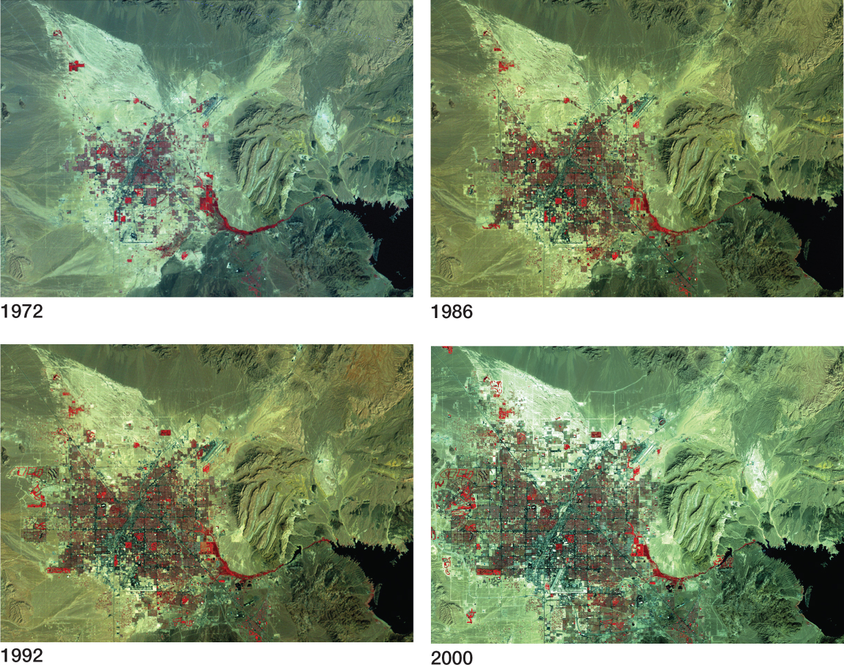
Geospatial information can also be gathered about other characteristics, such as the landscape, terrain, or land use. Remote sensing provides images of the ground that serve as “snapshots” of particular locations at specific times, which can generate other forms of spatial information. For instance, a satellite image of Las Vegas, Nevada, can help ascertain the locations of new housing developments. Examining imagery from several dates can help track locations where new houses are appearing (Figure 1.7). Similarly, geospatial technology can be used to determine where, spatially, new urban developments are most likely to occur, by analyzing different pressures of development on these areas.
10
Many types of decision making are reliant on useful geospatial information. For instance, when a new library is proposed to be built in a particular area, the choice of location is going to be important—the new site should maximize the number of people who can use it but minimize its impact on other nearby sites. The same type of spatial thinking applies to the placement of new schools, fire stations, or fast-food chain restaurants. Geospatial information fuels other decisions that are location dependent. For instance, historical preservation efforts seek to defend historic Civil War battlefield sites from urban development. Knowing the location of the sections of land that are under the greatest development pressure helps in channeling preservation efforts to have their greatest impact. With more and more geospatial technology applications becoming available, these types of geospatial problems are being taken into consideration (see Hands-on Application 1.3: Mapping Data Layers Online; Hands-on Application 1.4: Examining Real Estate Values Online; and Hands-on Application 1.5: Geospatial Technology and Emergency Preparedness for examples).
!geo! HANDS-ON APPLICATION 1.3
Mapping Data Layers Online
Online mapping applications that combine a number of different types of spatial data into a series of map layers are becoming increasingly common. A good, easy-to-use resource for viewing spatial information online is MapWV, a utility for mapping various layers of data about West Virginia. Open your Web browser, go to http://www.mapwv.gov, and select Launch Map Viewer. Under the Layers tab on the right-hand side of the Map Viewer, you’ll see two options: Reference Layers, and Basemap Layers. Under the Basemap Layers option, you’ll see a number of possible starting layers, including road maps and aerial photography (such as NAIP, from different years). Under the Reference Layers tab there are several other data layers for you to map—for instance, turn on the Hydrography, Public Land, and Populated Places layers, and bodies of water, publicly-owned sites like parks and forests, and towns and cities will appear as locations on the map. You can zoom in on a major city (such as Morgantown), a specific county, or a particular place of interest (such as a state park). Tools for zooming in and out of the map and navigating are on the Map Viewer’s left-hand side. Additional analytical tools available under the Tools tab will enable you to perform tasks like creating profiles of the surface terrain. Examine several of the layers for Morgantown, West Virginia, and see how they fit together in a geospatial context.
Expansion Questions:

Question
0FPThrGH58WCo6R0lw/6hT12mqhGiBQTKph99Fg73XuJDghO+qq3ADIbAkd24HGo441Opfo7Ap3XmcaiJ7EXEIfpA48fy0BASqjnxeZvJ30p8FU393gFjFZESt2jXkeWTWGf/Nkegb09LCxGcbZE1LajxDjU4BNI/vErtQIA5JxCYl7UP8p+EaNTc5bnVe3zE++dJA==-
Question
vjwV9stT0C6gTWa7iFFBjRekhT28tmbCUzpBiRJ3hpalnts8zLQI/qGKGnEU/w27AEHvGDKC6C+57Tda2DMJZez81jqcvp15pPf6DXp+Nd5JEqS1qIOJV1XWLouNKkRrgzEnH3Np+ZypAn8ED9ALa4XRlXuePyXhz3N6sA== -
Question
SRJ7/TjM6mMoXHVbtSurMTVu98F/TX9TCJojpc9ZSWENFpxTH/SXLzIzLYlty988ctYjES09K23J8Ryd8zpxo+s3gjxX4JmVP08J/1N7Xnrw2vD0cvSSO6MglEC4mcT9Zzel8zMvnFnHchGKa/KkFr0m/eVCsOybVpWVyjITfvYgI6JhJFtF2QnuqzuMPrBOSlAmEQ==
11
!geo! HANDS-ON APPLICATION 1.4
Examining Real Estate Values Online
Zillow is an online tool used to examine housing prices in cities across the United States. You can examine the prices of houses for sale in the neighborhood and see—spatially—where housing prices change. In other words, Zillow provides online mapping related to real estate prices and appraisal. To check it out, open your Web browser and visit http://www.zillow.com. Starting with the Find Your Home search option, look for houses in Virginia Beach, Virginia. Zoom in on some of the residential neighborhoods, and you’ll see markers in yellow (recently sold homes) and red (homes for sale). Selecting a marker will give you the sale (or sold) price, along with Zillow’s estimated market value. When you’re using this tool, you’re selecting a location and examining information (like housing prices and other details) that refers to this location.
Expansion Questions:
-
Question
6sajCuFTMwPjdbxdI1bcrmto+VjneVWhXKPL/XCas3GNwpnnA33jcVe0KMZVov6wt2dXAelrt1eispzSDhtyhacpRcMtAotbApLssf5M5gfNCpGcYr/xpbJ+PxW6+9Q0xCvdZy9beMxE8MY/bAkXqEUqDn7DBa06uHtBTq10jMs+E5Qv7JIN9M0kxch40Q/bHTKdzgqmZiQiIodSsRxshjJs+4PXdlFZGy7ERcMuNNgGw7yGskyK0stVNQZLJtbYKSS6K+6QwXc3N3jch/sJDCQaLBgKzXd3PnM0p0aXqi4//c8yN38qLQ== -
Question
+gdzZFoNQNEX2nEzQ13UXN0vf1hQ/E752rzrO/awx0dqaYOOjE5bvbLl0OdKEoFhASoyi1/Vvr1L7w3P8MuA3DYotZ0C8VOSplSmjp870OItPyTf7lSaQA==
!geo! HANDS-ON APPLICATION 1.5
Geospatial Technology and Emergency Preparedness
Geospatial technologies are used in many applications related to disaster management and emergency preparedness. A fun (but still useful) example of this is available in the Map of the Dead online at http://www.mapofthedead.com/map, which includes a free mapping tool intended to be used to help survive the “zombie apocalypse.” When the map opens, zoom in on your own local area—you’ll see the delineation of urban areas, as well as locations helpful in a disaster or emergency, such as gas stations, police stations, hospitals, and grocery stores. While surviving fictional outbreaks of the walking dead makes for good entertainment, this kind of Web mapping tool highlights how geospatial technology can be used to enable individuals to quickly find the locations of necessary resources in the event of an actual emergency, such as a flood, tornado, or hurricane. Along these lines, Google has set up an online emergency preparedness tool for the state of Florida at http://www.google.org/crisismap/florida_emergency_preparedness, which shows current weather radar conditions, shelters, evacuation routes, and current traffic conditions in order to aid in emergency preparation and disaster management for the state.
Expansion Questions:
-
Question
pLzdFCDcuTGQaSqvKaxBwdIY6XhxcybHQNDccqAguiSBw2iVE88YX5VbiEgUce+OrwzkmNPgls7FhcWNzv0Bk+jQfOEbxHAmkk14y1UgiDufLeCnDzGsHVPA1PtFZtZGctjMN96P72cDOKeeeb84/RDQw0SHTzCmkPXfZNqYzUgipauo -
Question
QDY5ajjyyiABKggv7JstZNQKPg6h2cgtqL7N8xd4oO1kZsaXdaiq/lJ4XOFCCggT0fW60qZl+CTXJre6Njj3EZXFFACNqnkcP9V3rFwUxeb911MvbSPvQIsEqryEYtWtB7LcpJ37Uq3xlkO3unk8j/P1e8zKzhd/Lxd2gIpKOdpRSt5jzLYxHSqeamE/ChJR/qI3aHr/8uG36oU0
12