4.7 What Are Some Applications of GPS?
GPX a standard file format for working with GPS collected by GPS receivers
GPS is used in a wide variety of settings. Any application that requires location-based data to be collected firsthand can apply GPS to the task. For instance, geologists use GPS to mark the location of water wells when testing groundwater, while civil engineers use GPS to determine the coordinates of items such as culverts, road signs, and manhole covers. Coordinates measured with a GPS receiver are commonly used with other geospatial technologies in GPX format, a standard for storing and mapping collected GPS data. Below you’ll see just a handful of the ways GPS is being used in businesses, jobs, and the public sector.
Emergency Response
When you make a 911 call, the call center is able to fix your location and route emergency services (police, firefighters, or ambulances) to where you are. When you make a 911 call from a cell phone, the Enhanced 911 (E-911) system can determine your position—either using the cell towers to determine where you are, or using a GPS receiver in your phone to find your location.
95
Farming
Precision farming methods rely on getting accurate location data about factors such as watering levels, crops, and soils. Having the ability to map this data gives farmers information about where crops are thriving and what areas need attention. GPS serves as a data-collection tool to quickly (and accurately) obtain location information for farmers (which can then be combined with other geospatial technologies, such as using Geographic Information Systems (GIS) to place the GPS data on a map.
Forensics
Recovery of human remains has been greatly assisted through the use of GPS. Rather than having to rely solely on surveying equipment, GPS can provide quick data and measurements, and can provide an additional tool in addition to other measurements made in the field. The same concepts have been applied to identifying the locations of artifacts and remains at archeological sites.
Public Utilities
City or county data for items that need to be measured manually (such as culverts, road signs, or manhole locations) can be done quickly and easily with GPS. When field-based data is necessary to create or update utility data, workers equipped with GPS can collect this type of data quickly and accurately.
Transportation
GPS provides a means of tracking travel continuously, whether on the road, in the water, or in the air. Since GPS receivers can receive signals constantly from the satellites, your travel progress can be monitored to make sure that you stay on track. When your GPS-determined position is plotted in real-time on a map, you can see exactly the point you’re at in your journey and measure your progress. Delivery and shipping companies can use this type of data to keep tabs on their fleets of vehicles, and to check if they deviate from their routes.
Wildlife Management
In much the same way you track vehicles, wildlife and endangered species can be tagged with a GPS receiver to monitor their location and transmit it to a source capable of tracking those movements. In this way, migration patterns can be determined and other large-scale movements of wildlife can be observed.
geocaching using GPS to find locations of hidden objects based on previously obtaining a set of coordinates.
Beyond its uses in the private and public sectors, GPS plays a big part in personal recreation. If you’re a runner, GPS can track your position and measure your speed. If you’re a hiker, GPS can keep you from getting lost when you’re deep into unfamiliar territory. If you’re into fishing, GPS can help locate places reputed to be well stocked with fish. If you’re a golfer, you can use GPS to measure your ball’s location and the distance to the pin. In fact, there’s a whole new form of recreation that’s grown in popularity along with GPS, called geocaching.
96
!geo! HANDS-ON APPLICATION 4.2
Things to Do Before You Go Geocaching
Geocaching is a widespread and popular recreational activity today. As long as you have a GPS receiver and some coordinates to look for, you can get started with geocaching. This chapter’s lab will have you investigating some specific geocaching resources on the Web, but before you start looking for caches, there are some online utilities to explore first. Open your Web browser and go to http://www.groundspeak.com. Groundspeak operates a main geocaching Website as well as providing some tools to use. On the main page there are links to several GPS-related sites:
- Geocaching.com: http://www.geocaching.com. Check around for locations of geocaches near you (we’ll use this during the lab).
- Waymarking.com: http://www.waymarking.com. This Website provides a way to find the coordinates of interesting locations (“waymarks”) that have been uploaded by users. Type in your zip code to see what’s been labeled as a waymark (and collect its coordinates) near you.
- Whereigo.com: http://www.wherigo.com. A Website to download a player and a toolset for constructing games (referred to as “cartridges”) and other applications for portable GPS devices.
- Cache In Trash Out: http://www.geocaching.com/cito. An environmental initiative dedicated to cleaning up areas where geocaches are hidden.
Expansion Questions:

Question
U6VDkhFwY1RzgsxAJzFCoP7ADPVUf3M0gJhbkai7wfO+KGdsn8gj/3zZz4HuhAiqHujV3qZLjpZP8f1IxYuKq6oL8sltxlbQ-
Question
M3TbE3bFlX5/ZMC1GxQ4XbYFhziUXXHqDl8Xxu73i1TVBF6gxfKjqf+5xIZvEIlTPwoVUwQc0wwGxfbARex9h5pYHk0Yua73/nNWn1eOprqGGlvHjIXRhUj1ro7ImSfnRhjuqBgHgrVCRy41iBmtutdJqrA9iamR
In geocaching, certain small objects (referred to as “geocaches”) are hidden in an area and the coordinates of the object are listed on the Web (a log is maintained). From there, you can use a GPS receiver to track down those coordinates (which usually involve hiking or walking to a location) and locate the cache. In essence, geocaching is a high-tech outdoor treasure hunt (see Hands-on Application 4.2: Things to Do Before You Go Geocaching). This type of activity (using a GPS receiver to track down pre-recorded coordinates to find objects or locations) is also used in educational activities, in and out of the classroom, to teach students the relationship between a set of map coordinates and a real-world location, as well as give them practice in basic land navigation and GPS usage.
geocoin a small coin used in geocaching with a unique ID number that allows its changing location to be tracked and mapped
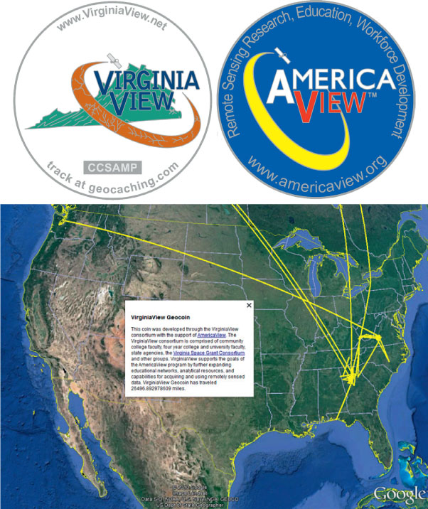
An example of the kind of item that’s used in geocaching is a geocoin, a small object about the size of a casino chip. A geocoin is “trackable” in that the unique ID number on the coin can be logged into the geocaching.com Website, and the location of where the coin is taken from and the location it’s placed in can then be mapped (see Figure 4.11). Geocoins are primarily for recreational geocaching but can also be used in several educational activities involving geographic studies. For example, VirginiaView (one of the StateView programs of the AmericaView consortium—see Chapter 15 for more information) has put together a set of lesson plans which involve students tracking geocoin movements, and relating these activities to larger projects like the tracking of invasive species and watershed characteristics. See VirginiaView’s Website, http://www.virginiaview.net, for further information on combining trackable geocoins with geographic education.
97
!search! THINKING CRITICALLY WITH GEOSPATIAL TECHNOLOGY 4.1
What Happens if GPS Stops Working?
What would happen if the Global Positioning System stopped working—or at least working at 100% capability? If the satellites stopped operating and weren’t replaced, GPS would essentially stop functioning. If the number of satellites dropped below full operational capacity, GPS would work some of the time, and quite possibly its accuracy would be greatly reduced. An operational failure of GPS forms the scenario of this article from GPS World: http://www.gpsworld.com/gps-risk-doomsday-2010.
If something like this came to pass, how would the lack of GPS affect life on Earth? What industries would be impacted by sudden deprivation of access to GPS? What would be the effect on navigation at sea and in the air, and how would other kinds of travel be disrupted? What would be the military implications if the world were suddenly deprived of GPS? How would all of these factors affect your own life?
Is society too reliant on GPS? Since Selective Availability was turned off in 2000, there’s been an overwhelming increase in GPS usage in many aspects of everyday life. Is the availability of GPS taken too much for granted? If the system could fail or be eradicated, what impacts would this have on people who have become reliant on the belief that this technology would always be available to them?
98